June 28: Media Visits Damaged Park, Views Crater

Early morning USGS photo of Fissure 8 on June 28, 2018. (Full-sized)
Today’s eruption summary

Exactly 8 weeks after the Lower East Rift Zone eruption began in Leilani Estates on May 3, Fissure 8 continues to gush unabated. Its fountains are contained within its 55-meter (180 ft) cone, and this morning’s overflight showed no active overflows.

For the past day or so, the lava river has crusted over on the last half mile to the ocean. This has allowed lava seeps, described by Steve Brantley in his Tuesday evening  talk, to creep into still-molten earlier flows on the northern side of the lava delta. This “lava seepage” is oozing into the ocean along a broad front, encroaching  onto what’s left of Kapoho Beach Lots on the northern edge of the flow:

USGS: “View of the ocean entry (lower left) from this morning’s overflight. Lava was entering the ocean across a broad area primarily on the north part of the lava delta. Upslope along the northern margin of the flow field, lava is still oozing from several points in the area of Kapoho Beach Lots. Fissure 8 lava fountain in the upper left. Note southward bend in the lava channel around Kapoho Crater.” (Full-sized)

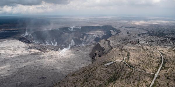
At Kilauea’s summit, the most recent collapse explosion occurred at 4:49am this morning, sending up an ash-poor plume about 1000 feet, with the energy release of a 5.3 earthquake. The sides of Halema’uma’u continue to collapse inward and downwards, especially during each explosive event.

Increased seismicity in the hours leading up to each explosion, up to 25-35 small earthquakes an hour, is wearing on the nerves of nearby Volcano Village. The USGS is meeting with them tonight to talk about the ongoing earthquakes, and released an excellent FAQ today: Frequently Asked Questions About Kilauea Volcano’s Summit Earthquakes.”

Local News Outlets Given Brief Tour of Summit

The big news today is that the National Park Service and USGS arranged a brief escorted tour for local news media to the rim of Kilauea Caldera, which has been closed to visitors for 49 days. There was also a half hour press briefing.

So today there’s suddenly a lot more videos and views of what the caldera looks like:

In fact, I’m going to put the news media links before the science segment of today’s post. Boldfaced articles include quotes, videos, and/or photos from the media summit tour.

Continue reading June 28: Media Visits Damaged Park, Views Crater

June 26: Steve Brantley’s Tuesday USGS Presentation

On June 26, 2018, Deputy Scientist-in-Chief of the Hawaii Volcano Observatory, Steve Brantley, gave a ten-minute slideshow at the Puna Community Meeting in Pahoa. Video of the meeting is posted here. Steve Brantley’s talk starts at 35:00 in that video.

BigIslandVideoNews excerpted half of his talk in this video, which they overlaid with footage from a June 24 USGS drone overflight of the summit:

Below is my transcript of the complete talk, including images that match or approximate his slides.

Steve Brantley (USGS):

Hello, everybody. Thank you for coming out.

I’ll just describe a few things occurring in the Lower East Rift Zone and then summarize the activity up at the summit at the very end.

Continue reading June 26: Steve Brantley’s Tuesday USGS Presentation

June 26: Drone Video of Halema’uma’u Crater

Today’s Eruption Summary

Kilauea’s double eruption continues with no significant changes: Fissure 8 is still pumping out lava,  and the summit is continuing to settle. The ocean entry has expanded to two miles wide, with its southern edge creeping south just onshore.

Here’s a timelapse of all the USGS lava flow maps since lava started moving away from fissures in May:

Fissure 22 is sputtering and sending out tepid little lava flows that don’t go anywhere, while Fissures 16/18 were “incandescent” during the morning overflight.

June 26th’s collapse explosion waited a full 29+ hours, just to keep us on our toes, occurring at 10:41pm HST.  The energy release was 5.4 with a 1000-foot ash plume.

Yesterday’s Mick Kalber Overflight:

While the daily collapse explosions at Kilauea’s summit haven’t sent up much ash lately, they’re still giving off a voggy burp of sulfur dioxide. And some of the ash that fell earlier is still blowing around and irritating communities at the southwest end of the island:

USGS: “Recent explosive events haven’t produced significant ash plumes from the summit, but downwind communities may still experience ashfall when previously erupted ash is remobilized. On authorized permission from Hawai‘i Volcanoes National Park, our Unmanned Aircraft Systems crew is conducting gas measurements at Pu‘u ‘Ō‘ō. They snapped this photograph from Chain of Craters Road – a plume of remobilized ash is clearly visible along the horizon. It is rising from the Ka‘ū Desert and blowing to the southwest.” (Full-sized)

The big news today is that the USGS posted new drone footage of Halema’uma’u Crater.

Full video below. If you want extra drama, here’s a version with a soundtrack added.

HVO/Jaggar Museum are the low dun-colored buildings (same color as the bluff they’re sitting on, well-camouflaged) swing into view at the top of the screen around 2:30 and are middle of screen at 2:40 just before it shifts to a new view. (The larger, more conspicuous buildings near the beginning of the video are the old Kilauea Military Camp and the Volcano Golf Country Club).

Here’s an aerial photo of Halema’uma’u from April 13, 2018 for comparison, with Jaggar Museum/HVO at the top of those stairstep bluffs in the background, middle right. Here’s another view of the two buildings.

USGS caption for today’s drone video:

Continue reading June 26: Drone Video of Halema’uma’u Crater

June 25: Ahulanui Ponds May Be Next

Today’s Eruption Summary

Fissure 8 is status quo. Today’s HVO Kiluaea status report says its cone is now 180feet tall. Its flow front has broadened southwards, widening to two miles, moving south on shore as well as continuing to expand offshore (lava delta acreage: ~405). The main channel/ocean entry remains on the southern side of the front, with minor entries in a 1-kilometer zone.

The lava Fissure 22 is weakly active; no activity observed at 16/18.

USGS: “This animated gif shows the fissure 8 tephra (cinder and spatter) cone morphology changes between June 15 and 24, 2018. During this time a shoulder grew on the channel side of the cone as the vent shifted from being two distinct fountains to three, then to a single source of voluminous roiling. The cone height is about 47 m (154 ft) from the hardened lava surface on which it was built.” Note: This isn’t a webcam but a temporary camera they set up; they have to download pictures manually. (Full-sized)

According to Mike Zoeller (UHI) at today’s 11AM conference call, the lava delta is advancing at less than 50m/day; it was 200/day a week ago.  The southern edge of the flow is a kilometer from Ahalanui Beach Park. Over the weekend, he observed top lava speeds of 25kph (15.5mph); Leslie Gordon (USGS) saw it max out at 35kph (21.75mph) last Friday night.

USGS: “USGS Hawaiian Volcano Observatory geology field crews maintain watch over the eruptive activity in the lower East Rift Zone and at Kīlauea’s summit. Here, a geologist documents the behavior of lava as it exits the Fissure 8 cone. Lava enters the upper channel traveling as fast as 30 km/hour (18 mi/hour).” (Full-sized)

After yesterday’s collapse explosion at 4:12, seismicity dropped from a high of 25-35 quakes an hour down to less than 10,  but had started to creep up again and was averaging 30 by dawn. On the livestream, I observed clouds of ash/dust in the crater’s interior at various times during the day. Today’s collapse explosion occurred at 5:03pm, equivalent of a 5.3, ash-poor plume rising less than 2000 feet.

Jun 24: chasing rainbows and lava with Mick Kalber. He was checking on a lava spillover uncomfortably near his house!  (Helicopter noise)

Reminder: HVO downgraded Kilauea’s aviation alert to ORANGE last night, because ash explosions have rarely risen above 10,000 feet since May.

Continue reading June 25: Ahulanui Ponds May Be Next

June 22: Four Weeks of Changes at Kilauea Summit

Today’s Eruption Summary
USGS: ” Lava continues to erupt at a high rate from Fissure 8 and flow within the established channel to the ocean. No channel overflows were observed during this morning’s overflight. The fountains have built a horseshoe-shaped cone as lava fragments are intermittently hurled onto and over the growing rim. Lava exiting the cone forms a series of standing waves in the uppermost section of the channel.” (Full-sized)

Fissure 8 continues as usual, sending its lava river down to the ocean at Kapoho, with a “dominant ocean entry on the south edge of the flow front…producing a large laze plume.” Minor, brief overflows upstream aren’t traveling past previous lava flows. Fissure 6 is inactive; 16 incandescent; 22 woke up and was fountaining weakly during  the USGS morning overflight.

USGS: “Halema’uma’u crater at 8:30 a.m., view is toward the south. Several benches are clearly visible within the crater. The benches are sections of the former crater rim and adjacent Kīlauea caldera floor that have incrementally dropped or slumped into the crater as the summit area has subsided since early May.” (Full-sized)

Seismicity at the summit was “elevated overnight” according to today’s only HVO status update at 8:45 am. There appeared to be a lot of rockfalls/isolated slippages on the livestream today, especially on the left rim, but the really-truly “collapse explosion” (as USGS is now calling them) occurred at 6:52pm, 5.3 energy equivalent, 500 foot ash plume.

I spent this afternoon putting together a gif of the last 28 days of HVO wide angle Kilauea images, using screencaps I’ve taken supplemented with screengrabs from the same webcam archived by Hawaii247:

Halema’uma’u Crater, May 24-June 22. Animation of screencaps from USGS/HVO Kilauea Summit wide-angle webcam. (Full-sized)

Yikes.

In today’s digest:
  • Video capture of today’s summit explosion (warning: dark)
  • USGS Questions and answers
  • crisp LERZ photos/videos from HCFD
  • Local news stations turning from lava to recovery
  • Double dose of Mick Kalber overflight vids
  • Usual striking images from great photographers

In case you missed it:
Transcriptions of June 19 Steve Brantley Presentation at Puna Community MeetingJune 21 Conference Call

Continue reading June 22: Four Weeks of Changes at Kilauea Summit

June 19: Steve Brantley USGS Talk on Eruption Status

On Tuesday, June 19, there was a Puna Community Meeting at Pahoa High School at 5pm. As usual, Steve Brantley of the Hawaiian Volcano Observatory/USGS gave an excellent slide presentation reviewing the current state of the Kilauea eruiption. He covered the “perched lava flow” in the Lower Rift Zone and the dramatic changes at the summit, placing each in context with previous similar events. (I didn’t realize there were records of many past Halema’uma’u collapses).

Video of the entire meeting is posted here. The USGS talk starts at 42:40. I’ve transcribed it below, adding photos when I have something close (and restoring his graphs/diagrams which don’t come through very well on video recording).

Steve Brantley, HVO/USGS:

Continue reading June 19: Steve Brantley USGS Talk on Eruption Status

June 19: Magnificent Desolation

Six weeks in, this eruption can still take one’s breath away.

USGS: During the helicopter overflight on June 18, crews captured this image of the growing Halema‘uma‘u crater viewed to the southeast. With HVO and Jagger Museum sitting on the caldera rim (right side, middle where the road bends to the left) it is easier to comprehend the scale of subsidence at the summit. The estimated total volume loss is about 260 million cubic meters as of June 15th. (Full-sized)

USGS: “Fissure 8 vigor increased overnight June 18-19 with lava fountains reaching up to 60 m (200 ft). Spatter built up the cone to the east and into the channel. In this photograph, spatter lands on the east cone and flows downward.” (Full-sized)
Today’s Eruption Summary

Today’s summit explosion came early, 5:05am HST, with a weak ash/gas plume that reached 5,000 feet above sea level (Kilauea is ~4,000). Every one of these explosions means more downdropping and subsidence, resulting in the colossal changes we’re seeing to Halema’uma’u.

In the Lower East Rift Zone, Fissure 8 climbed back up to 200 foot fountains last night, beefing up the sides of its cone with spatter (but not adding much more height).  This morning the river was full to the top of its levees with a few minor breakouts.

Some of these overflows made it past the edge of earlier flows. One went north up Pohoiki Road a short distance before stalling, while another crept northwest along Luana Street. Fissure 6, 15, 16 are “oozing” lava and steaming. Near the ocean, the channel has forked to create two ocean entries, but the only place where it’s still covering more land is a creeping southwest edge of the lava flow in the Vacationland area.

(Above vimeo channel is nothing but daily ocean entry videos.)

More USGS Images and Videos

Continue reading June 19: Magnificent Desolation

Jun 19: 11am USGS Conference Call

Fissure 8 from HCFC overflight, June 19, 2018. (Full-sized)

Link: Full audio for Tuesday, June 19 USGS media conference call

  • USGS Eruption update: Status quo continues for summit explosions and Fissure 8.
  • NWS: Tradewinds return Thurs eve/Fri, vog winds in meantime.
  • NWP tells about places that ARE open, park-related activities.
  • Question & Answer session…

Continue reading Jun 19: 11am USGS Conference Call

June 18: Harry Kim Needs to Rest

Today’s Eruption Summary
USGS gif of F8 lava flow  Jun 17.

Fissure 8’s still doing its thing, fountaining 150-180 feet overnight with 164 foot spatter cone. The usual minor spillovers on the channel to the ocean. Today the lava’s entering the ocean mostly on the south side of the lava delta in the vicinity of Vacationland. Fissure 16/18 are still oozing, and fissure 6 (the bright spot to the left of Fissure 8 on the LERZ webcam at night) is intermittently incandescent or spattering. Both are “forming small lava flows on top of the existing flows.

USGS on Facebook: “About midday, minor amounts of lava spilled over the channel levees but did not advance very far. USGS image taken June 18, 2018 of the upper flow field, just downstream from fissure 8. The ocean entry is marked by a visible plume in the upper left.”

The summit’s daily explosion occurred at 6:12 am, moment magnitude 5.3. It produced a “very small, minor plume that went no more than 500 meters above the ground.” (Brian Shiro in 11AM conference call):

I rewound the Kilauea livestream to watch. The crater was steaming with small white puffy clouds of morning condensation. I saw the window frame vibrate, but the short-lived plume of ash/steam obscured the crater rim, so I didn’t spot any downdrops or rockfalls like we’ve seen for the past few days.

Below: Lots of great photos of summit and LERZ lava field today, and excellent Q&As from USGS on social media.

Continue reading June 18: Harry Kim Needs to Rest

June 16: Things Moving Sideways or Down Quite Rapidly

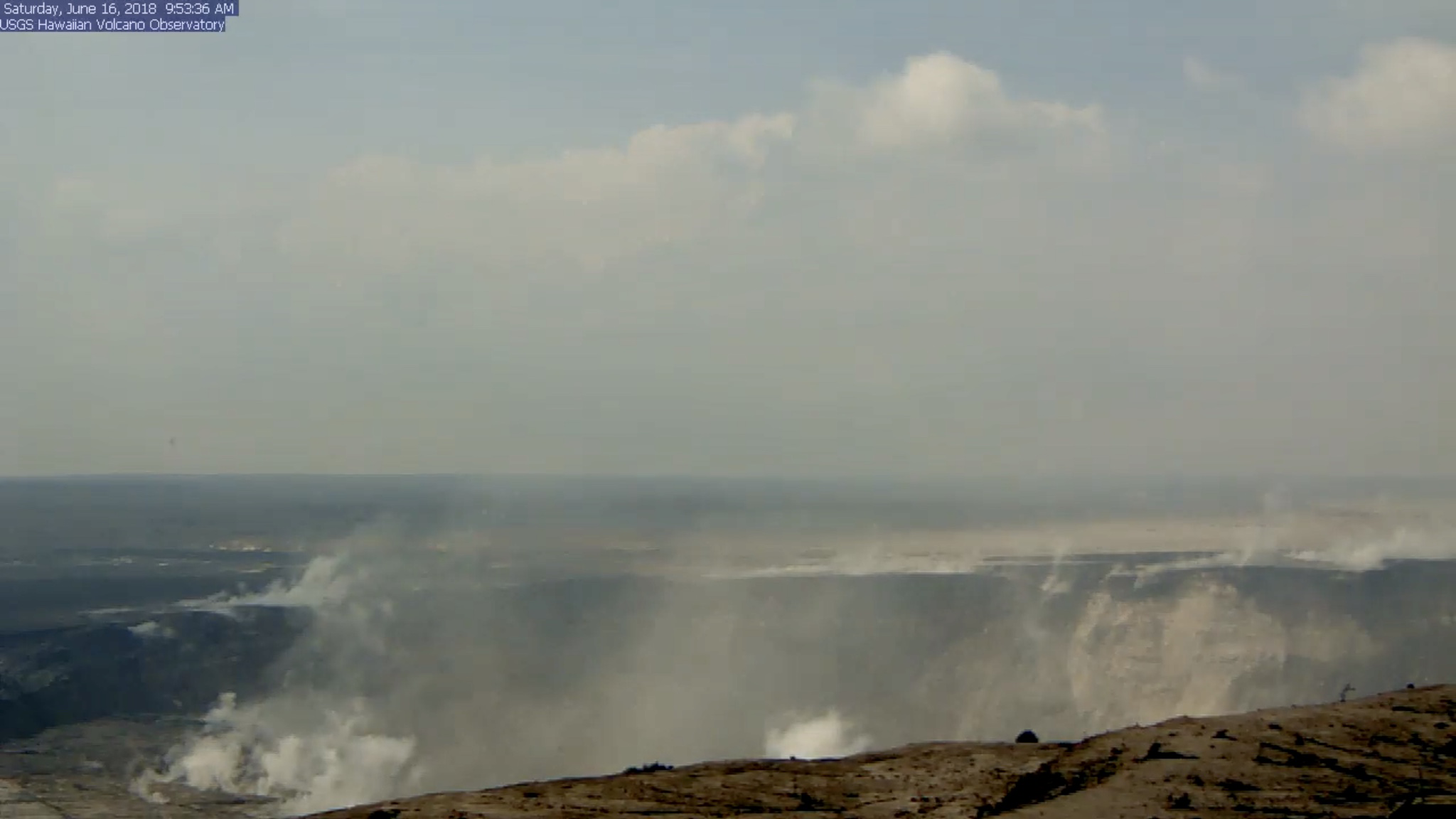
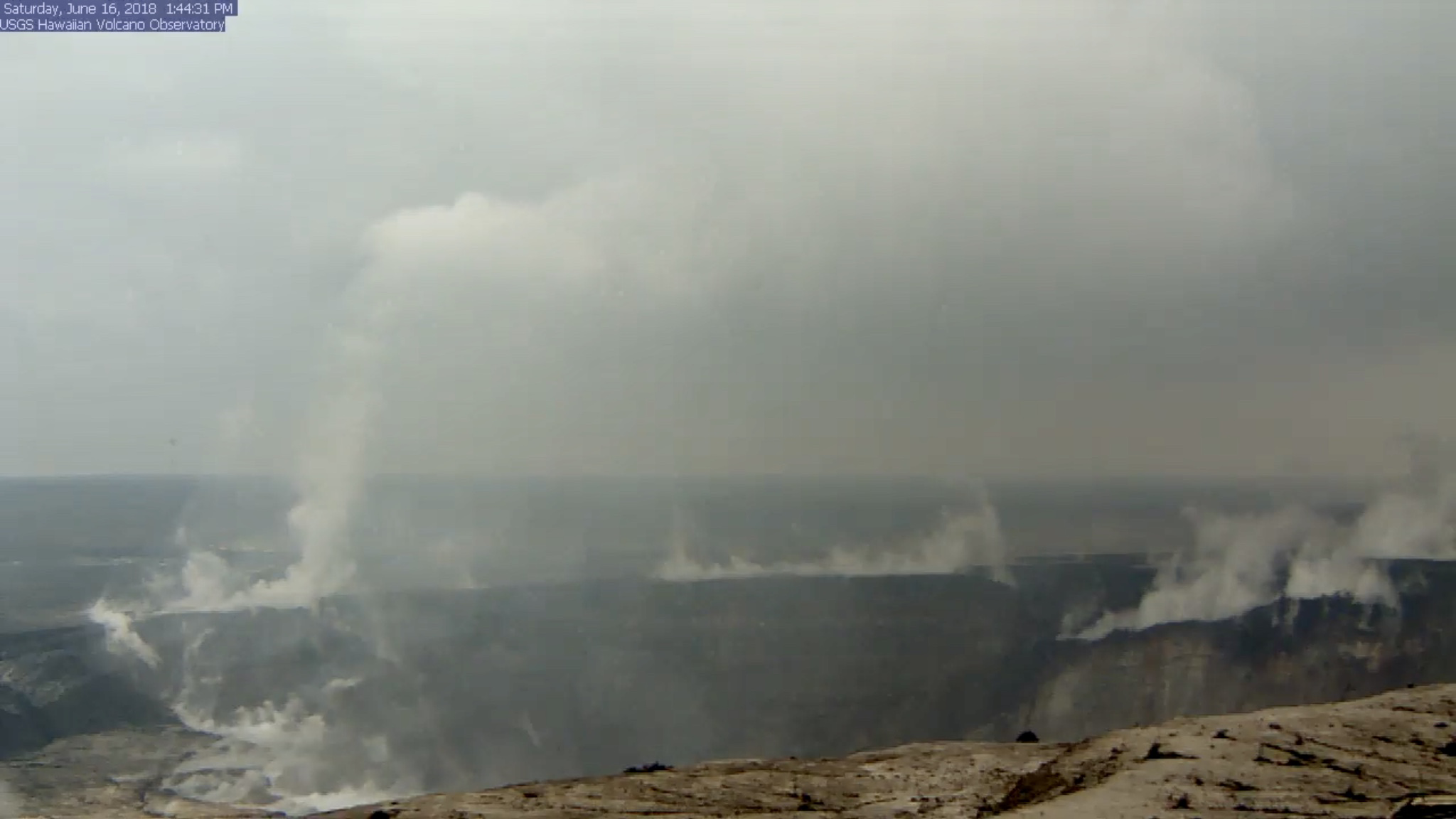
HVO’s Kilauea Summit Livestream caught today’s Halema’uma’u “subsurface explosion” (is that what we’re calling them now?) and — wow!

Halema’uma’u BEFORE: screengrab of USGS/HVO Kilauea Livestream before the day’s explosive event. I’ve boosted the exposure to bring out details. (Jun 16, 2018)

(a few hours later, when, luckily, it was still possible to rewind the livestream back to the time of the explosion, since I missed it.)

Halema’uma’u Crater AFTER: screengrab of USGS/HVO Kilauea Livestream taken later in the day after the dust had settled. Look at that big chunk of the rim that dropped on the right!

We’ve been hearing about subsidence, slumping, and rockfalls for weeks, but there’s nothing quite like seeing it, even if the video’s a bit fuzzy. I took the liberty of saving a clip:

Radar showed the plume was less than 7000 feet, and as usual the energy release checked in at 5.3.

While I rewound the livestream to grab that clip before it fell off the “back” of the livestream conveyor belt, it looks like I jumped right over this:

There was still a column of steam at that spot when I checked an hour later, but I don’t recall it spinning.

Okay, enough fiddling with the livestream. 

What else happened today? Same as the last few days, to the point that I had to double-check the date on today’s HVO  Kilauea status report.  Fissure 8’s cone is holding at 170 feet, fountains currently around 185-200 feet. Fissure 16/18 continues to ooze.

The lava river is running as fast as ever:

Despite the increased vog due to lack of tradewinds, that’s the clearest overflight video I’ve seen in days.

Mick Kalber notes the pahoehoe channel now cuts all the way through the a’a field to the ocean, which may explain recent videos of lava racing at amazing speeds…

Continue reading June 16: Things Moving Sideways or Down Quite Rapidly