August 13: Pele Is Sleeping, Part 2

August 13, 2018. USGS: “Ocean entries were small and scattered this morning, but lava had made no significant advance toward Isaac Hale Beach Park. The Pohoiki boat ramp remains intact, but access from it to the open bay has been cut off by a sand bar that extends from the jetty to the shore. As molten lava streams into the ocean, it shatters into small glassy fragments, forming black sand that’s transported along the coast by longshore currents.” (Full-sized)
Eruption Summary: the Lull continues

Fissure 8 is still emitting a gas plume, and lava circulates weakly within the cone. Residual lava is still draining into the ocean near Pohoiki. Gas emissions at the summit, Pu’u O’o, and even the Lower East Rift Zone are low.

August 13, 2018. USGS: “During their overflight this morning, HVO scientists observed no new activity at any of the lower East Rift Zone fissures. At the fissure 8 vent, a “puddle” of sluggish lava remained in the cone. No other incandescent lava was seen along the fissure 8 channel, except at the ocean entry. Some other fissures were steaming, as seen here.” (Full-sized)

[This post is a followup to yesterday’s, where I reviewed HVO news, photos and videos from the past week. Here, I’m covering everything else: local news media outlets, images/videos from local photographers, and a week’s worth of good Q&A from HVO/USGS on social media.]

Miscellaneous SCIENCE-y news

Timelapse of Kilauea Caldera Aug 2-9

August 12 LERZ Overflight

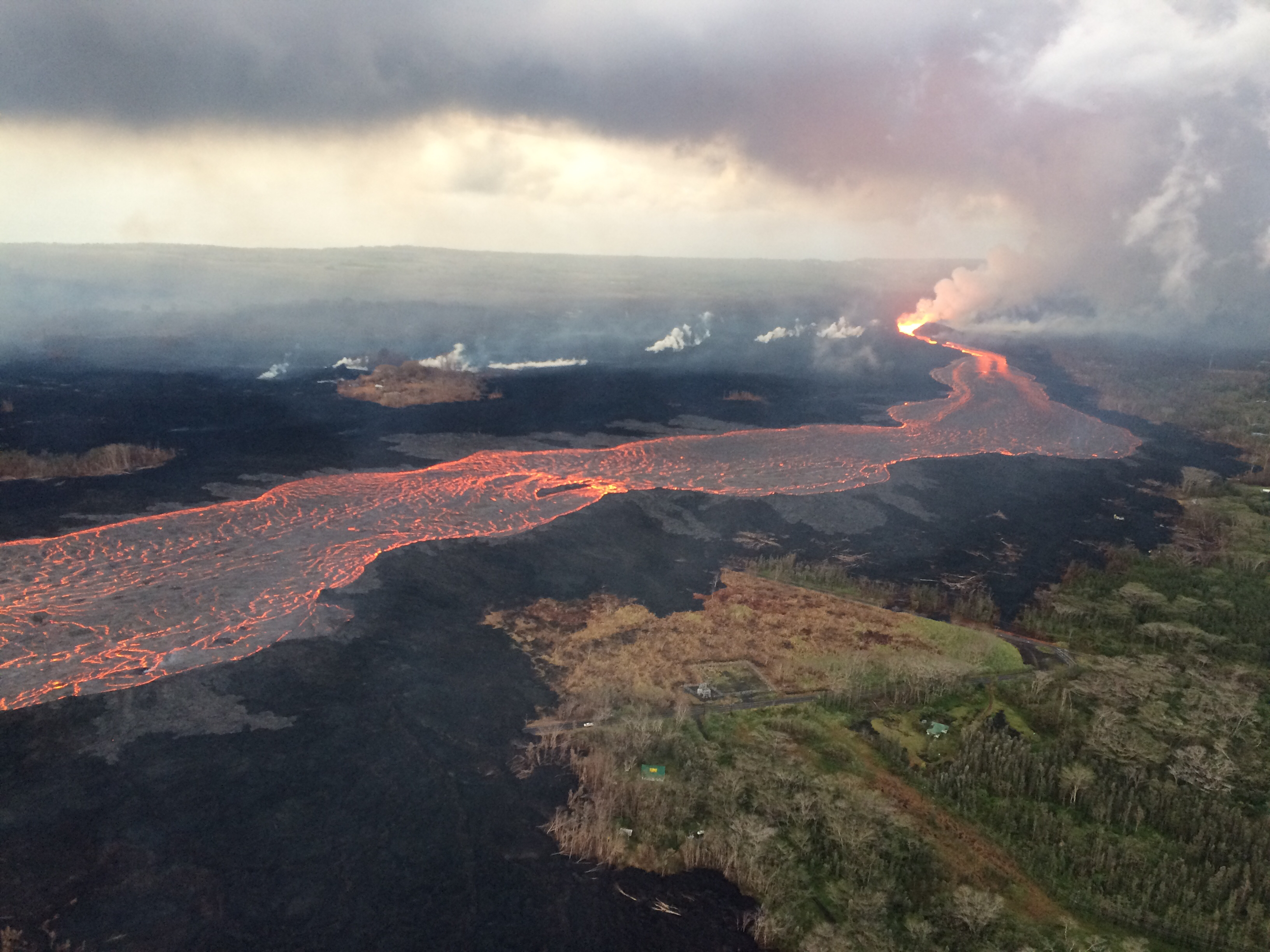
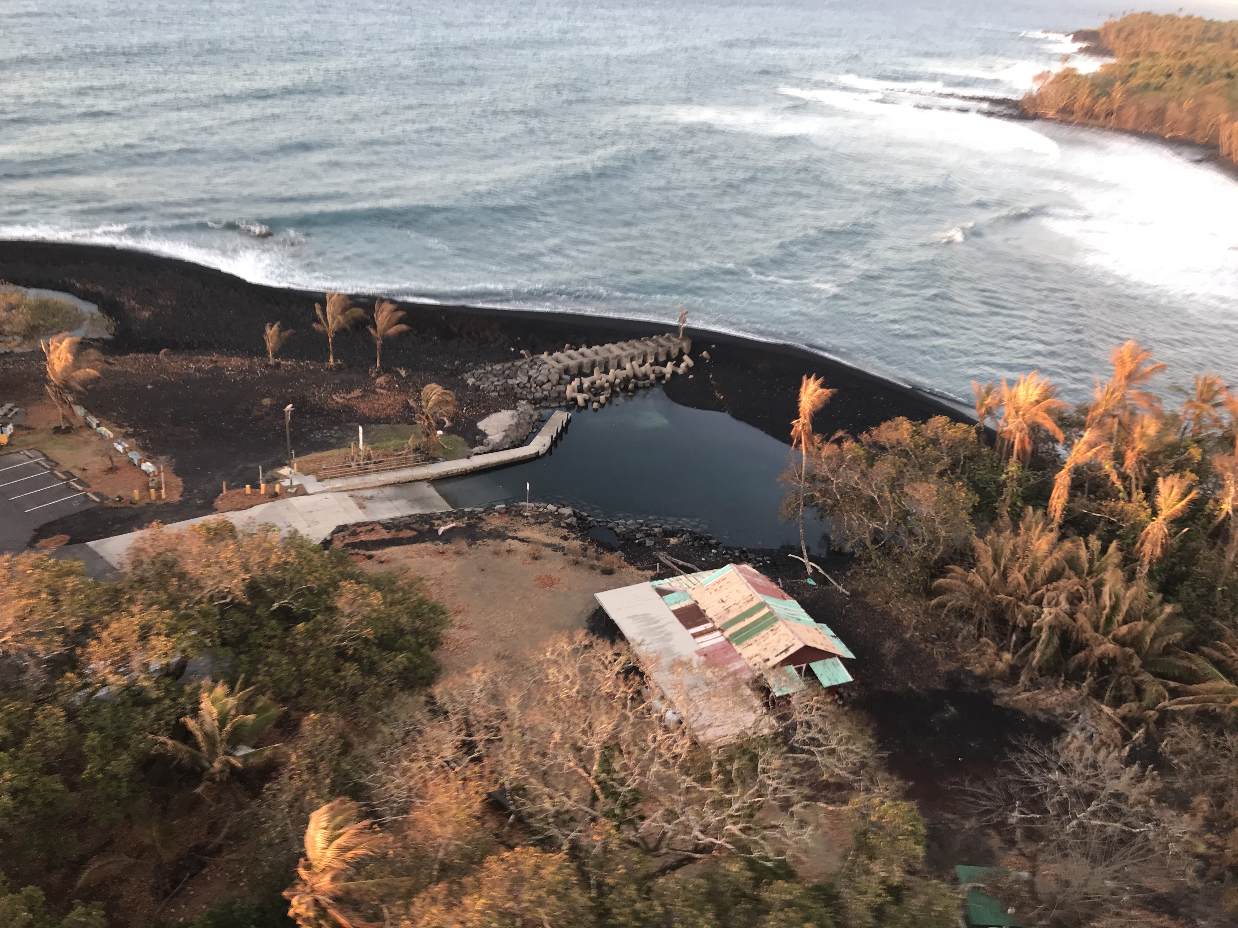
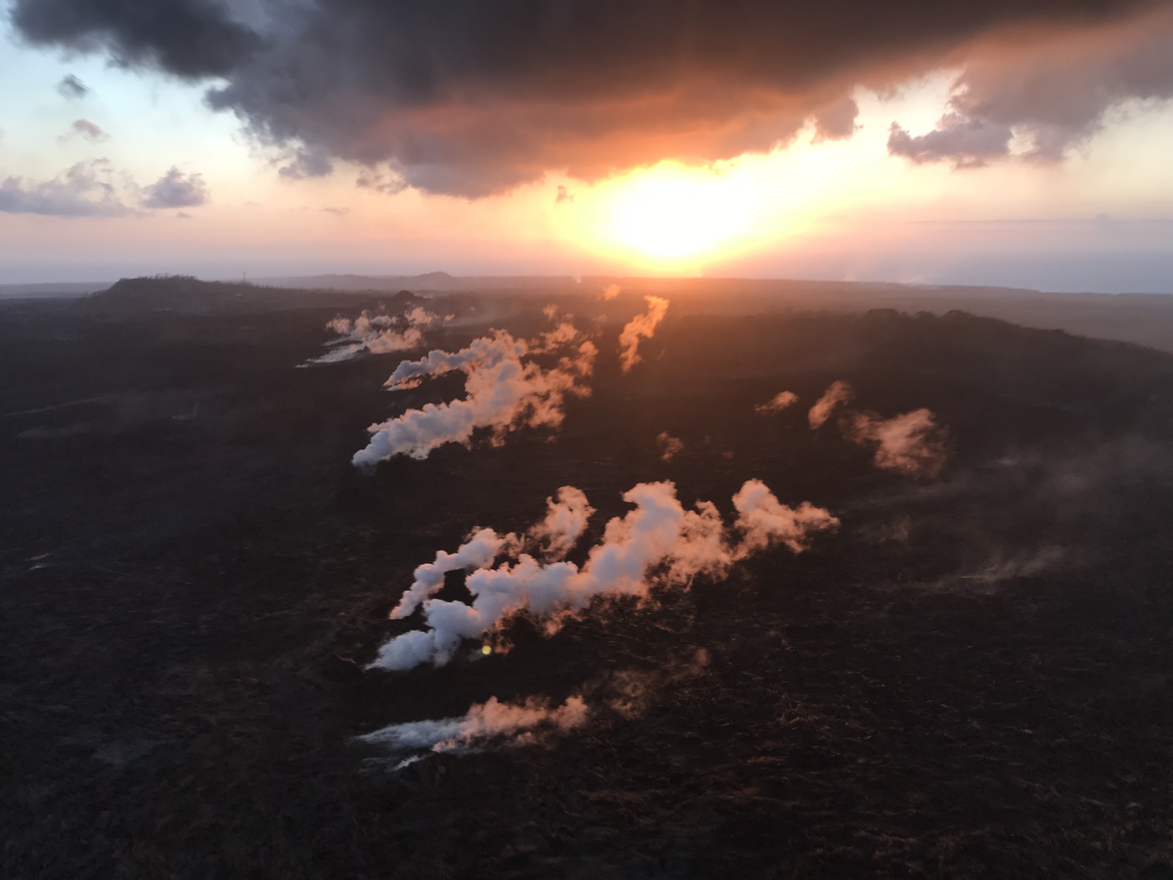
The latest from the @HotSeatHawaii gang. Mick Kalber’s August 12 video shows a few fingers of red lava dribbling out of the delta, and Pohoiki’s new sandbar which is currently blocking the boat ramp, but that can be moved. There’s a quick sweep over the weakly steaming fissures of the LERZ and a glimpse into Fissure 8’s cone, and then they tried to take a distant look at Kilauea’s summit:

Here’s Mick’s observations from this flight.

Bruce Omori posted photos of the same flight on Facebook, including:

Continue reading August 13: Pele Is Sleeping, Part 2

June 27: Farm Animals Airlifted

Prelude

Here’s an excellent 13-minute retrospective of Kilauea’s eruptions from the early 20th century right through June 25, 2018.

Now back to the present.

Today’s Eruption Summary
USGS: “At 10:41 p.m. HST on June 26, after approximately 25 hours of elevated seismicity, a collapse explosion occurred at the summit producing an ash-poor steam plume that rose less than 1,000 ft above the ground surface before drifting to the southwest. The event was captured by an HVO webcam in moonlight (plume in bottom of photo), located in the HVO observation tower.” (Full-sized)

It’s 11:30pm HST, and it looks like today’s “collapse explosion” is going to happen tomorrow. Are the explosion spacing themselves out more now?  Too early to tell. There has been always some variation in their timing, despite the fact that it feels like we’re watching a magmatic equivalent of Old Faithful.

View of Fissure 8 cone and lava channel from USGS morning overflight. (Full-sized)

Meanwhile, Fissure 8 continues exactly what it has for— what, a month now? Fountains contained within its 180-foot spatter cone continue to pour out an 8-mile river of lava. Occasional spillovers near the head of the river usually don’t go past the margin of previous flows in this eruption. Fissure 22 is once again showing “incandescence” and pushing out small, short lava flows.

The ocean entry area fans out across a 1-km stretch of coast, but the bulk of the lava is dumping into the sea from Fissure 8’s main channel. Unfortunately, the northern margin of the lava flow has reactivated, too, pushing further into what’s left of Kapoho Beach Lots community.

USGS on Twitter: “Morning overflight revealed northern margin of flow field at the coast is oozing fresh #lava at several points in the area of #KapohoBeachLots. Small channel overflows feed short #pahoehoe flows.” (Full-sized)

USGS: “Lava continues to enter the sea along the southern Kapoho coastline. Lava enters the ocean primarily through an open channel, but also along a 1-km (0.6 mi) wide area. Also visible in the image (center right) is an area at the northern margin of the flow field that is oozing fresh lava at several points in the area of Kapoho Beach Lots.” (Full-sized)

And that’s about it. Except that even with status quo, there’s some unusual sights and itoday. Such as this literal “Lava boat”:

Continue reading June 27: Farm Animals Airlifted

June 19: Steve Brantley USGS Talk on Eruption Status

On Tuesday, June 19, there was a Puna Community Meeting at Pahoa High School at 5pm. As usual, Steve Brantley of the Hawaiian Volcano Observatory/USGS gave an excellent slide presentation reviewing the current state of the Kilauea eruiption. He covered the “perched lava flow” in the Lower Rift Zone and the dramatic changes at the summit, placing each in context with previous similar events. (I didn’t realize there were records of many past Halema’uma’u collapses).

Video of the entire meeting is posted here. The USGS talk starts at 42:40. I’ve transcribed it below, adding photos when I have something close (and restoring his graphs/diagrams which don’t come through very well on video recording).

Steve Brantley, HVO/USGS:

Continue reading June 19: Steve Brantley USGS Talk on Eruption Status

May 4: First Full Day of Eruption, 6.9 Earthquake

Friday was a busy day. Starting before sunrise, more fissures erupted (USGS night video). Here’s a USGS video of Fissure 3: first cracks, then steam, and eventually lava spatter.

At 12:33PM. a magnitude 6.9 earthquake knocked out power to some customers, agitated the summit lava lake (video clip), sent up yet more ash from Pu’u O’o (video clip), and caused minor local sea level fluctuations (Good article: Honolulu Star-Advertiser). Also see informative HVO Volcano Watch photo essay.

Below: Interview of HVO geologist Jim Kauahikaua, prior to 6.9 quake. Big Island Video News added lava footage from David Corrigan, Mick Kalber, Ikaika Marzo.

Excerpts from above interview:

Continue reading May 4: First Full Day of Eruption, 6.9 Earthquake