June 15: Summit Explosion Captured on Livestream

USGS: “Photograph taken during helicopter overflight captures fissure 8 lava fountain.” This one’s wonderfully moody with subtle textures close up. (Full-sized)

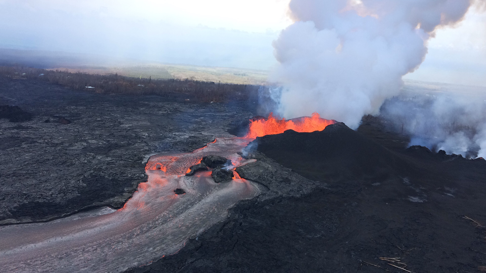
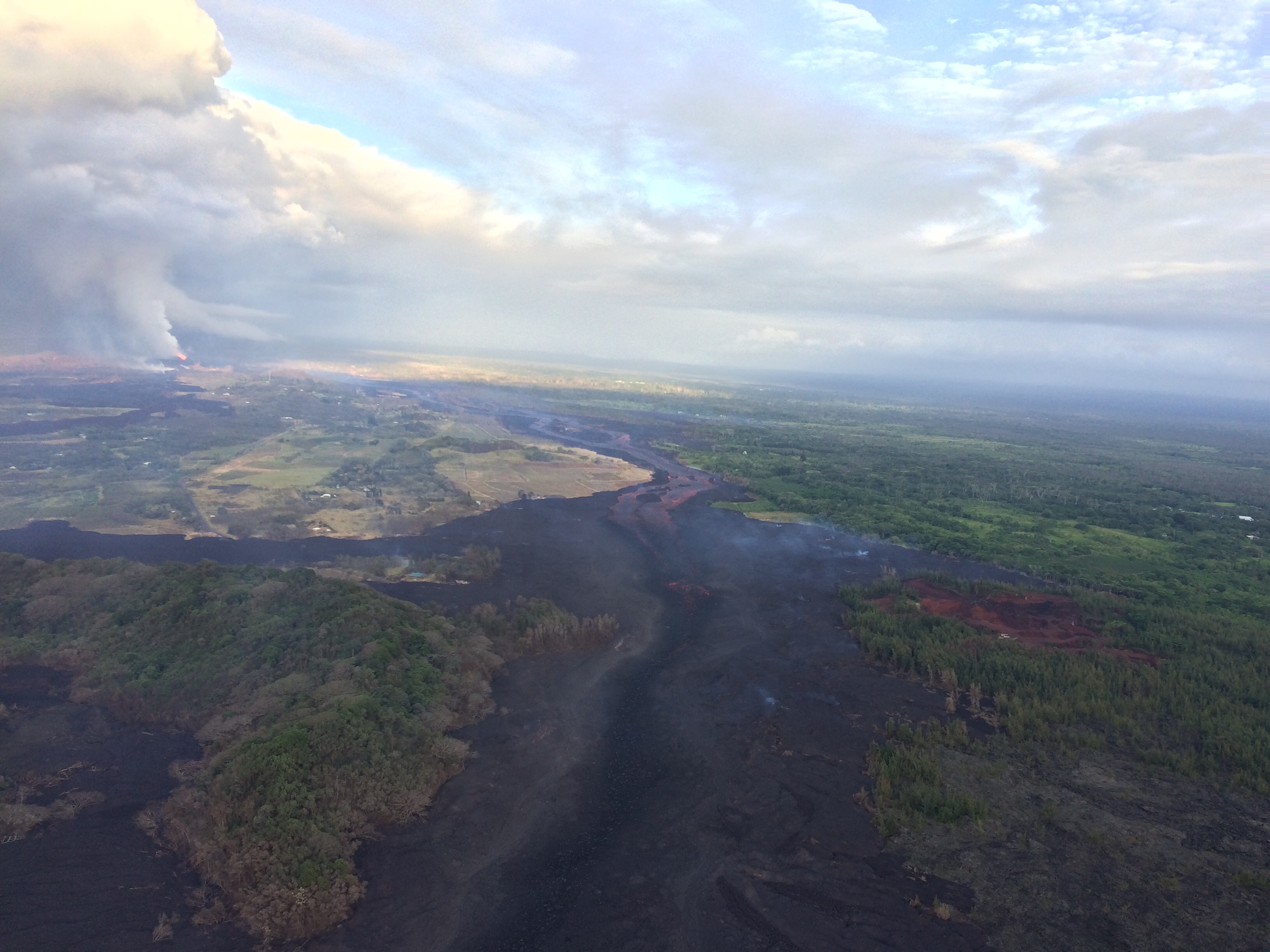
Lava fountains rise and fall, but the river they  feed remains the same: a vigorously-flowing channel down to a wide ocean entry, with occasional small overflows slopping over the levees (banks). Last night, Fissure 8’s fountains were reaching 200 feet; today they dropped again to 100-130 feet with bursts up to 180.  Its cinder cone, built of spatter and tephra falling around the fountains, is now 170 feet tall.

When is somebody going to name this pu’u? 

USGS: “Lava fountains from Fissure 8 reach heights of 200 ft overnight. The cinder and spatter cone that is building around the fissure is now about 165 ft at its highest point. At times, fissure activity is hidden behind the cinder and spatter cone, as shown in this image.” (Full-sized)

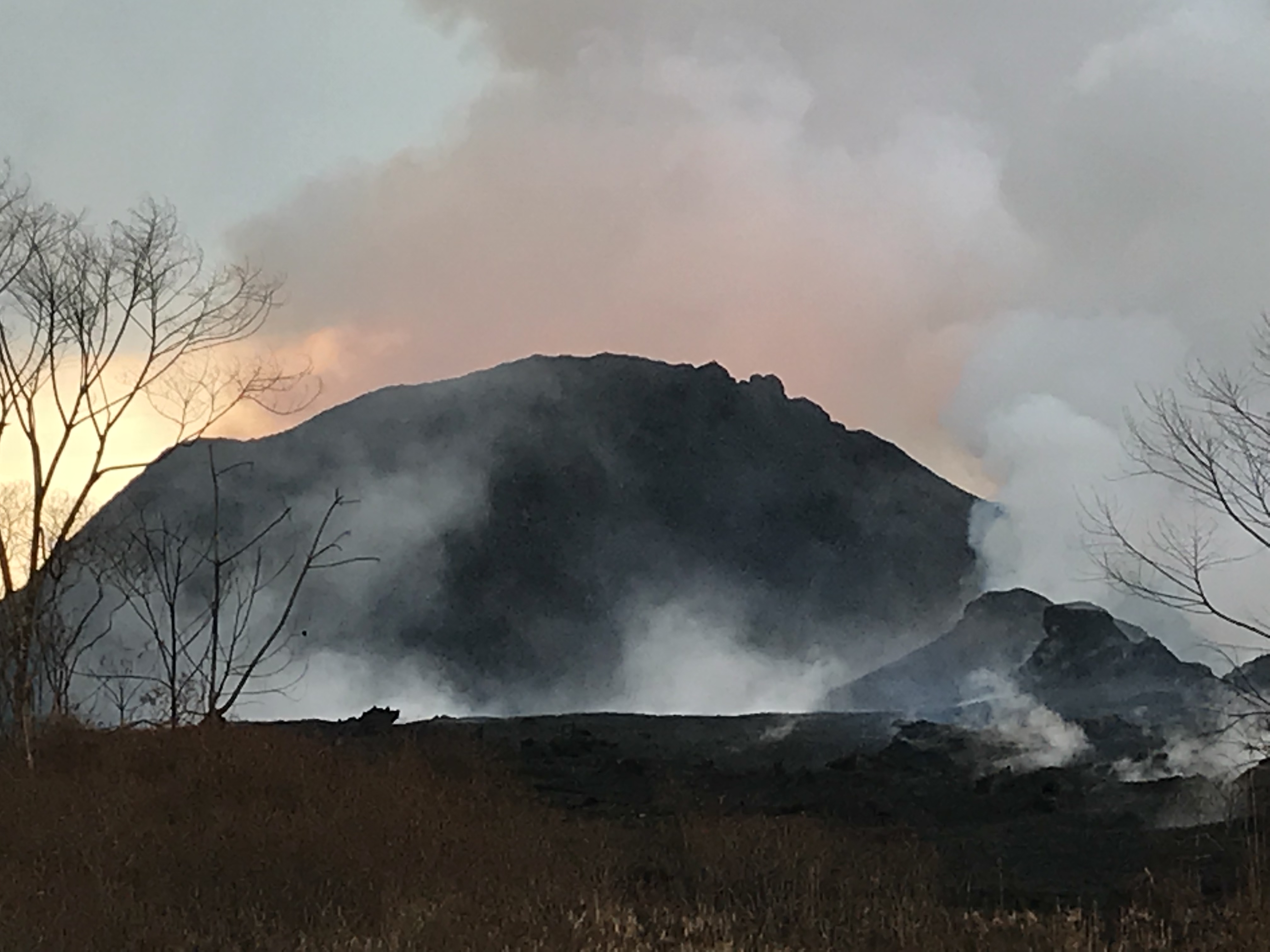
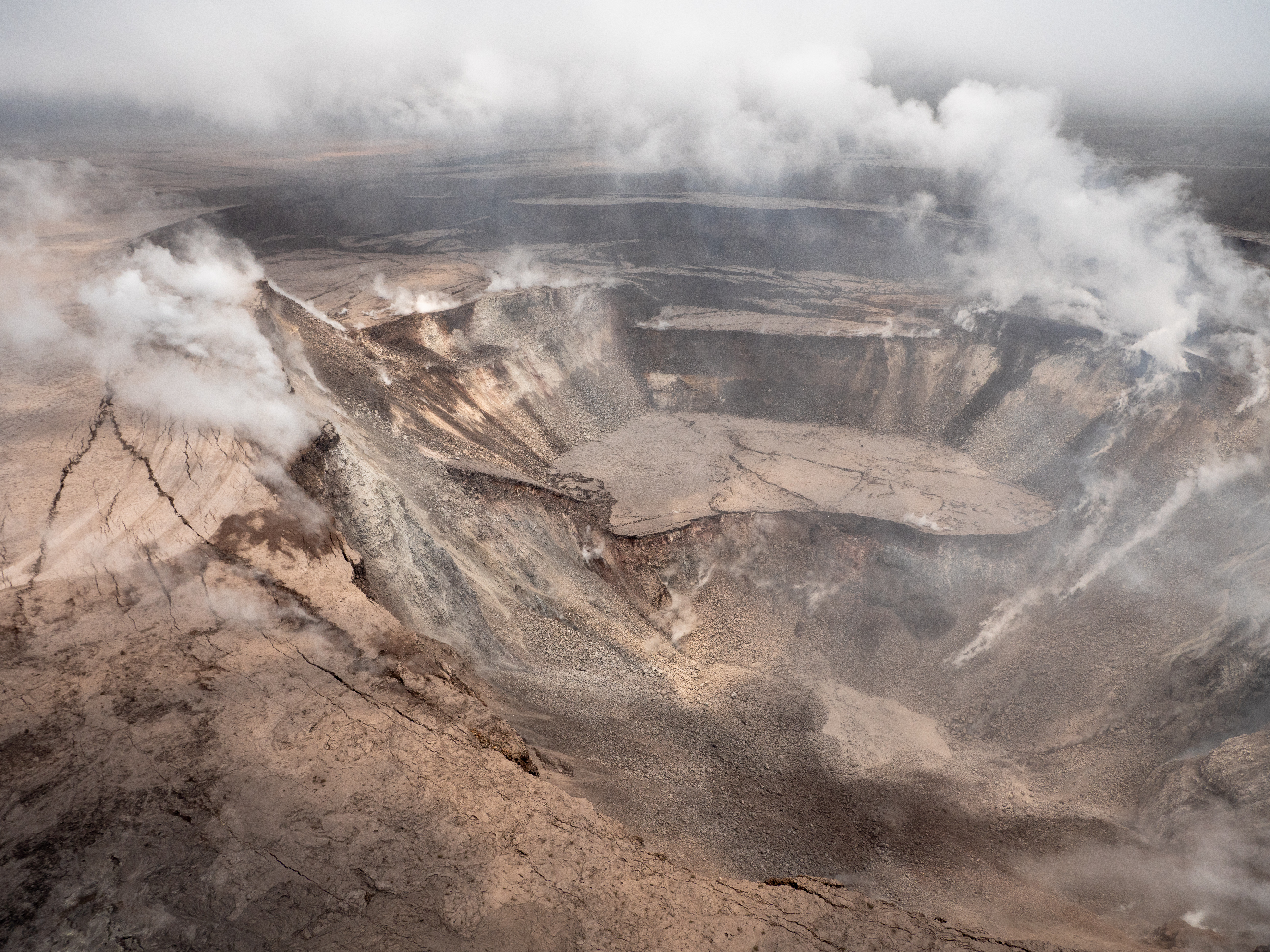
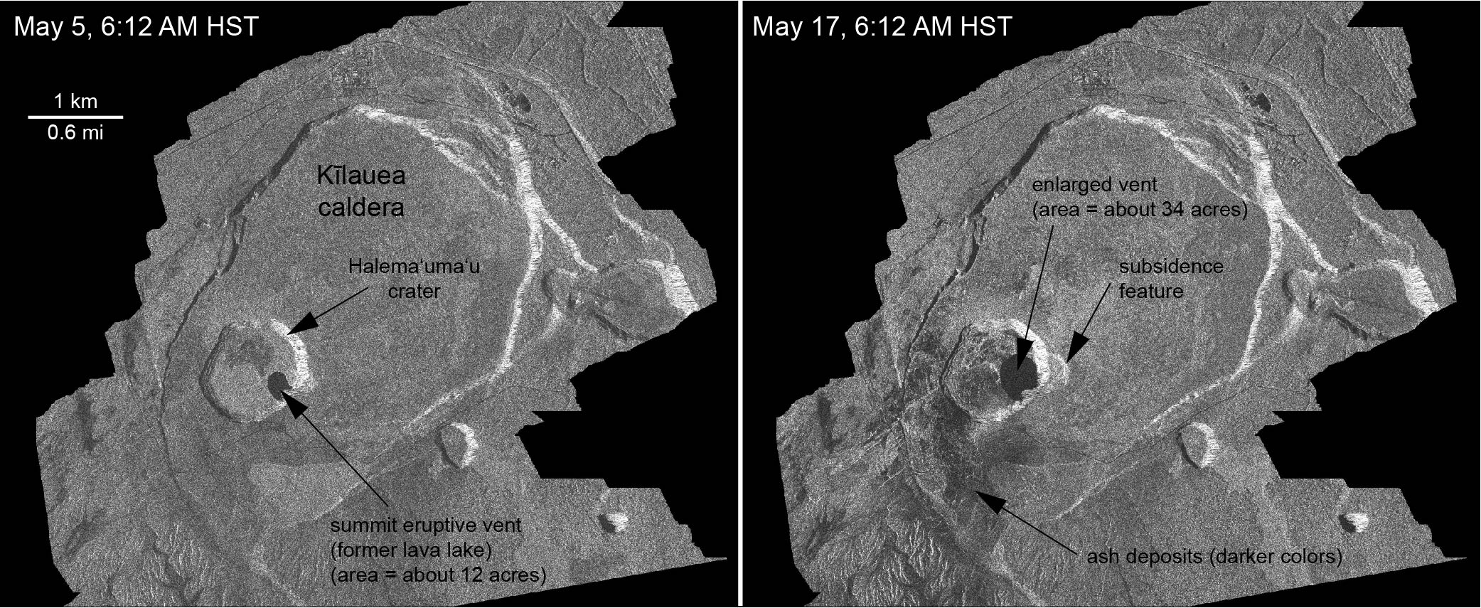
Frequency of earthquakes ramped up Thursday night, with more M3s than before. Today’s M5.3 summit explosion was late, finally popping at 11:56am, sending up an ash-poor (?) cloud 10,000 feet. HVO: “It didn’t produce a distinct plume, which is why we say ‘ash and gases’ instead.” This cycle of daily explosive events has been going on since May 26 or 29, depending on how rigidly one defines the pattern.

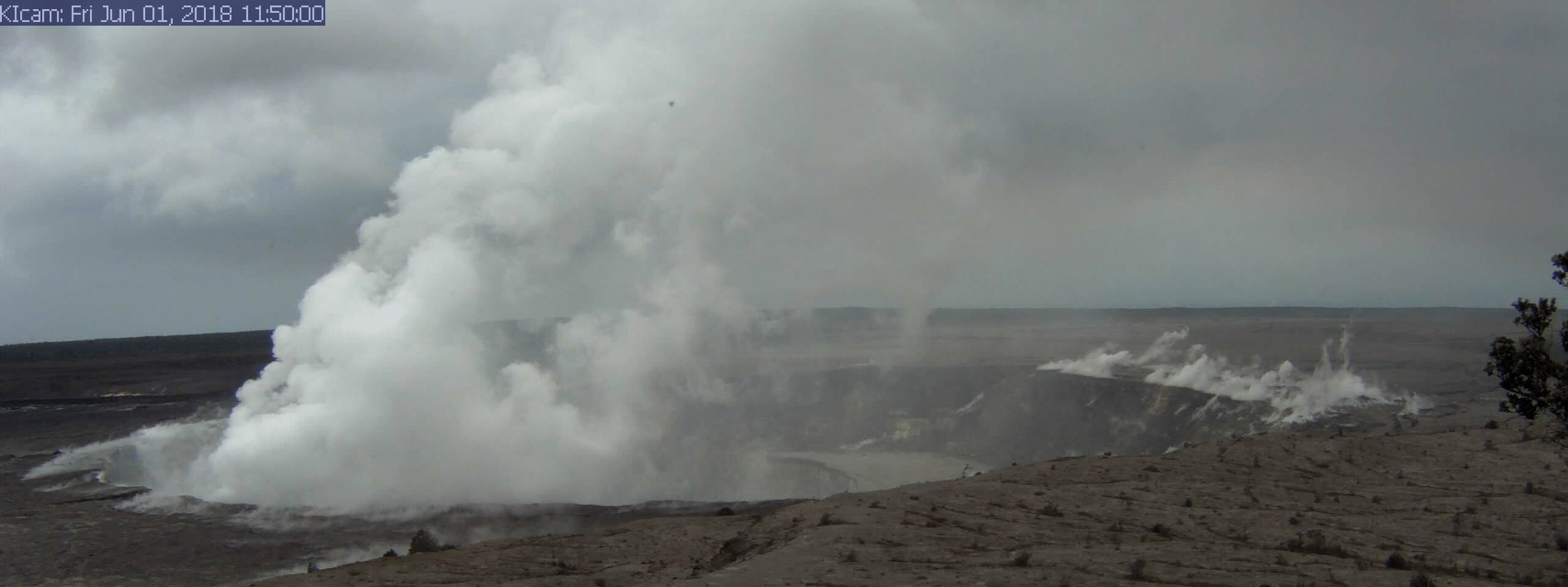
All right, let’s get to the science. And a rather foggy but nevertheless genuine video clip of one of Halema’uma’u’s daily explosions.

Continue reading June 15: Summit Explosion Captured on Livestream

June 13: Towering Laze, Big Hole in the Ground

Today’s eruption summary:

Lower East Rift Zone: Fissure 8 continues to build its oblong cinder and spatter cone. Overnight fountain heights were 130-140 ft, up to 53m (174ft) by the afternoon. Fissures 16 and 18 continue weak activity.

USGS: “Fissure 8 fountains to heights of 130-140 ft. The lava spatter chills and the fragments are building a cone on the downwind side, now nearly as tall as the fountain itself.” (Full-sized)

Fissure 8’s lava flow had a “towering” steam plume at its ocean entry point this morning. Areas of offshore upwelling have become more dispersed.

6AM overflight of Kapoho, “towering” laze plume at ocean entry of Fissure 8 lava flow. (Full-sized)

The daily summit explosion was at 3:39am, equivalent to M5.4 earthquake, with an ash plume 7-8K feet (NWS radar has been repaired). Slumping and subsidence continue at Halema’uma’u, and SO2 emissions remain about half pre-event levels.

Before and After: Changes at Halema’uma’u

Here’s a good view of Halema’uma’u taken at Hawaii Volcanoes National Park, April 19, 2018 by Christoph Strässler (Creative Commons):

Gorgeous photo of Halema’uma’u Crater and its lava lake, April 19, 2018 by Christoph Strässler (Creative Commons). See his photo album for more images from this visit.

Compare with this animation from HVO webcam June 1-10, or the new drone footage later in this post.

USGS: “A series of wide-angle webcam images, captured by a camera in HVO’s observation tower between June 1 and June 10, 2018, show ongoing subsidence around Halema‘uma‘u at the summit of Kīlauea in this animated GIF.” (Full-sized)

Today’s Kilauea news daily digest is full of science, science, science! the usual slew of incredible pictures. Also, some glimmers of hope for lava evacuees, although as usual bureaucracy moves at the speed of of dirt.

Continue reading June 13: Towering Laze, Big Hole in the Ground

June 12: Halema’uma’u’s Collapse Continues

Summit:  Today’s “Type A” explosion occurred at 1:52am. It produced almost no ash this time, although there’s still light ash and SO2 coming out of the crater from time to time. The view of the continued slumping/subsidence of Halema’uma’u crater is impressive (also see Jun 9 video on Twitter):

USGS: “Events at the summit of Kīlauea over the past few weeks have dramatically reshaped Halema‘uma‘u, shown here in this aerial view, which looks west across the crater. The obvious flat surface (photo center) is the former Halema‘uma‘u crater floor, which has subsided at least 100 m (about 300 ft) during the past couple weeks. Ground cracks circumferential to the crater rim can be seen cutting across the parking lot (left) for the former Halema‘uma‘u visitor overlook (closed since 2008). The deepest part of Halema‘uma‘u (foreground) is now about 300 m (1,000 ft) below the crater rim. The Halema‘uma‘u crater rim and walls continue to slump inward and downward with ongoing subsidence at Kīlauea’s summit.” (Full-sized)

Fissure 8’s cluster of vents is erupting up to 160ft today. With the cinder cone that’s built up around them, they’re mostly hidden. It’s entering the ocean today along a broad front. Fissure 16/18 are spattering weakly; this is the “weak activity” reported for the past few days. Apart from that, the Lower East Rift Zone is quiet, although other fissures are still releasing gasses.

The good news is, Fissure 8’s lava flow has built up such high, broad banks that unless it overflows them, it probably won’t cover many more homes or cut off new areas. The bad news is, the lava river could still break its levees, and there’s no guarantee other fissures won’t reactivate. USGS field crews reported a “non-erupting crack” in the Lower East Rift Zone with “temperatures as high as 430°C (806°F).”

Note, however, high temps may not indicate imminent changes. USGS clarified on Facebook: “This was at Fissure 10, which has long displayed high temperatures (fortunately, no SO2 was detected). It does not mean an eruption there is imminent, but rather it is a place where various superheated gases are escaping.” Similarly, there’s been high temps at the cracks across Highway 130, which have steamed but so far not erupted at all.

USGS overflight photo, morning of June 12. Fissure 8 and Leilani Estates. I think that’s Nohea Street. (Full-sized)

Somewhat abbreviated Daily Digest today because I started late, and then took forever transcribing 11AM conference call. But the stunning pictures keep coming…

Continue reading June 12: Halema’uma’u’s Collapse Continues

June 11: USGS Conference Call: What’s Causing Summit Explosions?

Once again the USGS media conference call at 11AM is full of so much juicy info I’ve moved it to a separate post rather than make my daily digest 10 pages long.

July 10, 2017 HVO webcam panorama of Halema’umau compared with June 10, 2018. (Click for Full-sized)

BigIslandVideo hasn’t put their edited/abridged version up, which they usually enhance with recent video footage. But they cut a lot of the Q&A anyway.

Below are my paraphrase/notes on the full, unabridged conference call (I skipped a non-geology questions where answer is “Agency X handles that; ask them.”]

Continue reading June 11: USGS Conference Call: What’s Causing Summit Explosions?

June 12: Steve Brantley (USGS) Weekly Talk on Eruption

I didn’t realize I’d missed one of Steve Brantley’s excellent 10-minute slideshow presentations at the weekly Puna Community Meetings. This one took place on Tuesday, June 12 at Pahoa High School.

I learn something from every one of these talks, which sum up Kilauea eruption activity of the past week in a way that’s easy for the general public to understand without talking down to them.

Video of meeting is archived here. Steve’s presentation starts at timestamp 42:10. Where possible, I’ll be including images in my transcript which match his slides.

(Steve Brantley is a USGS geologist, deputy-scientist-in-charge of Hawaiian Volcano Observatory.)

Transcript

Hello everybody. Thank you for coming out again and thank you for your perseverance. I’ll show a couple slides of what’s been happening down in this part of the neighborhood and end with some slides of the summit area, which continues to change very dramatically.

Cutaway Diagram of Kilauea Volcano, adapted from USGS Characteristics of Hawaiian Volcanoes. (I’ve adjusted text and drawn arrow to match Steve Brantley’s slide in his presentations.)

So this is  the overview slide I’ve showed for the past few times. It gives you the overall picture. It’s an image, cartoon, from the summit area all the way out to the eastern tip of the island. The summit area here [under “Kilauea Caldera” label], eastern tip [down by “Kapoho Crater”], with a cross section showing you the general picture of the magma reservoir system from the summit of the volcano down through the East Rift Zone and into the Lower East Rift Zone.

Continue reading June 12: Steve Brantley (USGS) Weekly Talk on Eruption

June 11: USGS Press Conference (Halema’umau Subsidence, Ocean Upwelling)

At a 3PM press conference, Jim Kauahikaua (USGS geophysicist) described in detail the subsidence at Halema’uma’u. He also talks about a patch of “upwelling” where lava has entered ocean at Kapoho and seems to be traveling along ocean floor, heating water above it.

(Transcript below the cut)

Continue reading June 11: USGS Press Conference (Halema’umau Subsidence, Ocean Upwelling)

June 11: Summit Hiccups, Ocean Entry Upwelling

Fissure8’s “three closely space fountains” are starting to climb down, reported at 115-130 feet last night, and “fluctuating heights from below the 115 ft high spatter cone around it up to 180 feet” this afternoon. But its lava flow is still full to its banks, entering the ocean in Kapoho with minor steam explosions. “Weak lava activity” was spotted at fissure 16/18 last night.

USGS: “The three closely spaced lava fountains at fissure 8 reached maximum heights of 115-130 feet overnight. Lava fragments falling from the fountains are building a cinder-and-spatter cone around the erupting vent, with the bulk of the fragments falling on the downwind side of the cone. Fissure 8 continues to feed a channelized lava flow that reaches the ocean at Kapoho.” (Full-sized)

Last night, Kilauea’s summit hiccuped: there was a small explosion at 12:46am, after which, seismicity did not drop off until after another, larger explosion at 4:43am like the ones we’ve seen lately (registered as M5.4).

USGS: “A series of wide-angle webcam images, captured by a camera in HVO’s observation tower between June 1 and June 10, 2018, show ongoing subsidence around Halema‘uma‘u at the summit of Kīlauea in this animated GIF.” (Full-sized)

Since Saturday, Fissure 8’s gas emissions have been much higher than last week, whereas summit SO2 is half what it was before the current eruption. (I’m not sure why HVO’s Kilauea alerts report “volcanic gasses” for one and only SO2 for the other.)

(The “Lava Livestream” house is still safe, if marooned, near white mast): 

USGS: “Aerial view of the fissure 8 lava channel on Kīlauea Volcano’s lower East Rift Zone in the vicinity of the Kapoho cone, with fissure 8 fountains visible in the distance (upper left). Helicopter overflights of the eruption site are routinely scheduled to check for any new outbreaks of lava and to collect GPS data on the active flow—information that’s needed to make the flow field maps that are posted on HVO’s website” (Full-sized)

Here’s a double feature from Mick Kalber’s daily overflights— below is his June 11 lava video, but I missed his June 10 flyover vid and lava update notes.

Below the cut: more great images, overflight vids, and some interesting USGS answers to questions on social media.

Continue reading June 11: Summit Hiccups, Ocean Entry Upwelling

June 5: Steve Brantley (USGS) Sums Up Eruption So Far

At a public talk in Pahoa, Hawaiian Volcano Observatory Deputy-Scientist-in-Charge Steve Brantley gave a 10-minute talk on the 2018 Kilauea eruption sequence so far.

I was going to summarize it in my June 6 Kilauea daily digest. However, it’s so useful I’ve transcribed it in full below.

The full community meeting is archived here, with Steve Brantley’s presentation starting at 44:30. BigIslandVideoNeed has excerpted it below, but they don’t usually show the slides he was showing. I’m going to be putting those back in, matching or approximating the photos he selected.

Steve Brantley, HVO/USGS: “Good evening and thank you for coming out tonight. […]

Continue reading June 5: Steve Brantley (USGS) Sums Up Eruption So Far