Today’s Eruption Summary
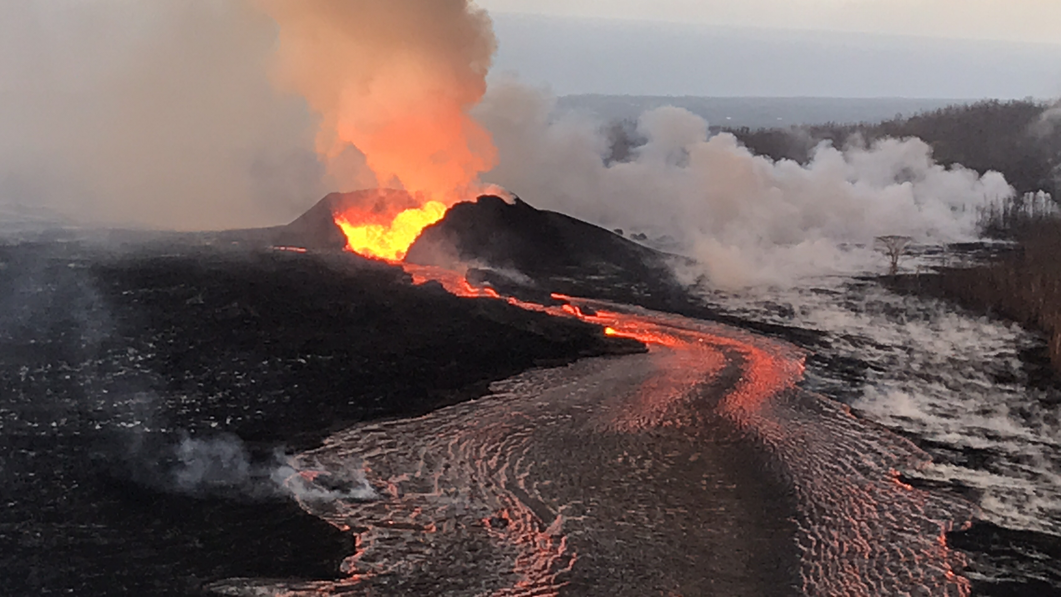
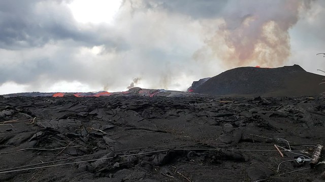
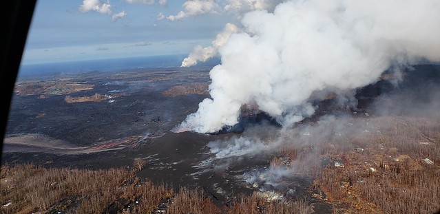
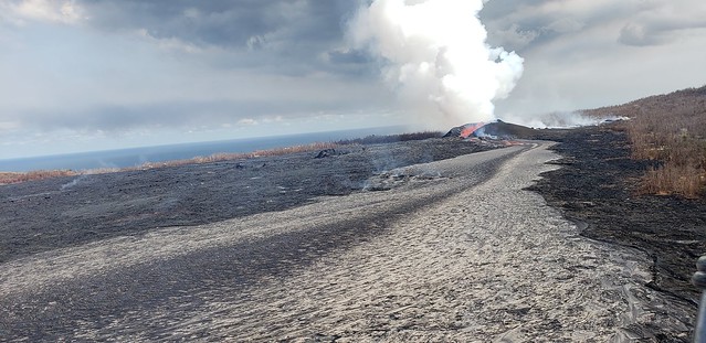
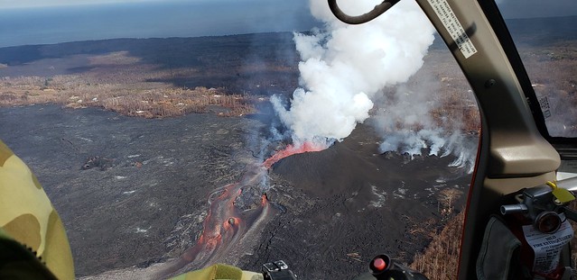
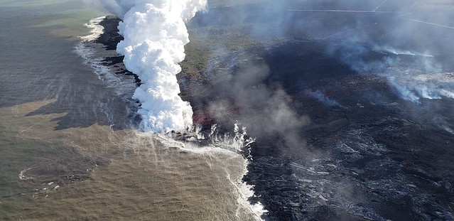
Fissure 8 continues as usual, sending its lava river down to the ocean at Kapoho, with a “dominant ocean entry on the south edge of the flow front…producing a large laze plume.” Minor, brief overflows upstream aren’t traveling past previous lava flows. Fissure 6 is inactive; 16 incandescent; 22 woke up and was fountaining weakly during the USGS morning overflight.
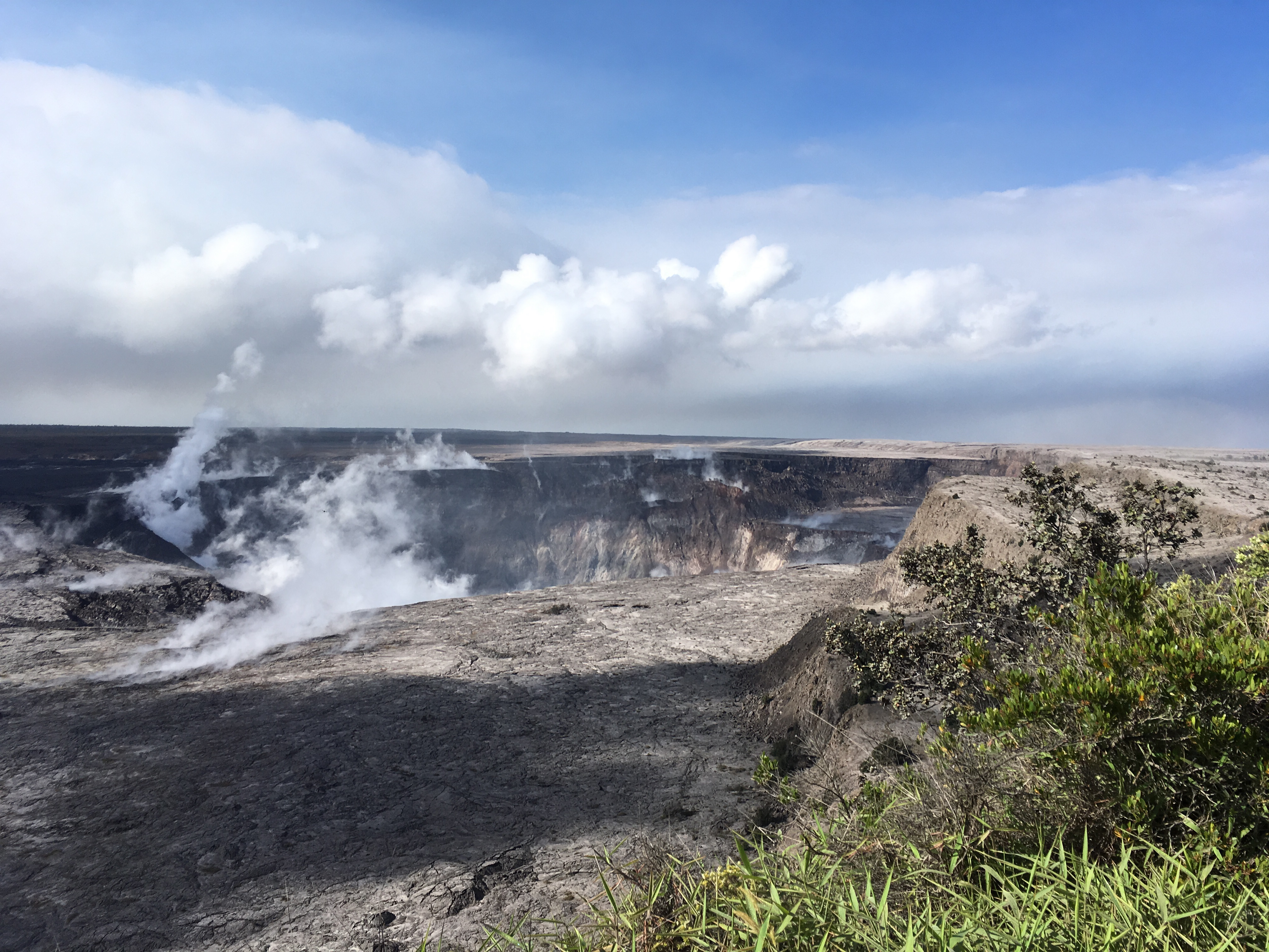
Seismicity at the summit was “elevated overnight” according to today’s only HVO status update at 8:45 am. There appeared to be a lot of rockfalls/isolated slippages on the livestream today, especially on the left rim, but the really-truly “collapse explosion” (as USGS is now calling them) occurred at 6:52pm, 5.3 energy equivalent, 500 foot ash plume.
I spent this afternoon putting together a gif of the last 28 days of HVO wide angle Kilauea images, using screencaps I’ve taken supplemented with screengrabs from the same webcam archived by Hawaii247:

Yikes.
In today’s digest:
- Video capture of today’s summit explosion (warning: dark)
- USGS Questions and answers
- crisp LERZ photos/videos from HCFD
- Local news stations turning from lava to recovery
- Double dose of Mick Kalber overflight vids
- Usual striking images from great photographers
In case you missed it:
Transcriptions of June 19 Steve Brantley Presentation at Puna Community Meeting | June 21 Conference Call
“Explosive Events” now called “Collapse Explosions”
Mike Zoeller, UHI, Center for Study of Active Volcanoes: We’re using this new terminology, “collapse explosion” for these events at the summit, because they are really a mixture of different processes going on. We’re not 100% sure whether the explosion triggers the collapse or vice versa. So, to cover our bases, we’re referring to them as “collapse explosions” at this time. — June 21, 11AM USGS/media conference call
USGSVolcanoes Q&A ON SOCIAL MEDIA
USGSVolcanoes on Facebook: (can’t link to individual comments):
Q: Some unlucky resident whose house is behind Fissure 8’s cone wants to know chances of cone collapse and flow going back that way.
USGS: The cone appears fairly sturdy at the moment. The more likely scenario is a channel breakout, which could send lava along the local line of steepest descent. Unfortunately, we can’t predict where and when those will occur, but we are monitoring the channel closely for weak spots.
Q: Could large earthquake near Leilani cause perched ponds/levees to breach, sudden outflow?
USGS: It wouldn’t necessarily require an earthquake, but yes, the perched channel and ponds could have levee breaks that would create fast-moving lava flows. We don’t expect that to happen at the same time all along the channel, but we are constantly monitoring from the ground and air to make sure no one is surprised by an outbreak.
Q: Why is lava flow crusting over? Flow rate slowing? Cooler?
USGS: It’s simply a normal process for a lava flow. The difference between the air and the lava is nearly 2,000 degrees F, so the lava is essentially “freezing” on contact with the air.
Q: Looks like increased earthquakes in LERZ- does that mean more magma intrusion further down the rift?
USGS: According to our plots, there have been relatively few earthquakes in the LERZ (5 in the past week, a few 10s of earthquakes in the past month). More earthquakes might indicate a new batch of magma, but there seems to be a relatively clear pathway at the moment, so there’s no need for the magma to break rock on its way to the surface.
Q: Compared to other cones around island, is Fissure 8 small?
USGS: They are tens to hundreds of feet in height, so well in line with this cone.
Q: What are the white birds flying in the livestream?
USGS: Our summit teams think they are Koa`e kea.
David Starrett [random FB user, but sounds informed]: They are Koa’e’kea, or White-tailed Tropic Birds. They actually nest in the crater, I have seen them along the wall of the crater on the north west side from the trail near the parking area NE of the Jaggar Museum.
Q: Is Halema’uma’u wide enough to be considered a caldera?
USGS: It could be considered a nested caldera. Kilauea already has a summit caldera.
USGSVolcanoes on Twitter:
Q: Was Fissure 8’s “well-defined channel” a river-bed before, or just path of least resistance?
USGS: There may have been some small water drainages along the path that the fissure 8 flow followed, but no, there was no major river there. [Lava flows build their own channels/levees!]
Q (Jacob E Laurishke): “Will the narrowing and tubing of the secondary channels have any longer term effects on flow capacity or does the increased velocity fully compensate?”
USGS: The increased velocity compensates for the narrowing in the channels in certain spots. At the moment, the flow rate appears to be the same.
Rumor Whack-a-Mole
Yesterday, USGS announced the alert level of Mauna Loa had been lowered to green, explaining that its seismicity for the past six months is lower than it’s been in years. Today, they’re swamped with “Is Mauna Loa about to erupt?!” questions, even after posting:
Mauna Loa back to "normal." Earthquakes diminished, deformation slowed, activity at background levels. HVO lowers alert/color code of #MaunaLoa to NORMAL/GREEN. https://t.co/2DVvWK52Gw pic.twitter.com/DJVrh0q9Gq
— USGS Volcanoes🌋 (@USGSVolcanoes) June 23, 2018
A couple of many rumor whack-a-mole tweets today:
USGS: As an active (but not erupting) volcano, #MaunaLoa will have earthquakes as part of its normal, background activity. Since late 2017, rates of seismicity and ground motion related to inflation of shallow magma reservoirs have slowed to (pre-2014) background levels.
USGS: [to someone saying they’re still feeling earthquakes on Mauna Loa]: As we have explained before, you are feeling earthquakes from Kilauea, which continues to have elevated seismicity as a result of the ongoing summit activity. That fact that you can feel an earthquake from a spot on Mauna Loa does not mean its epicenter is *located* on Mauna Loa.
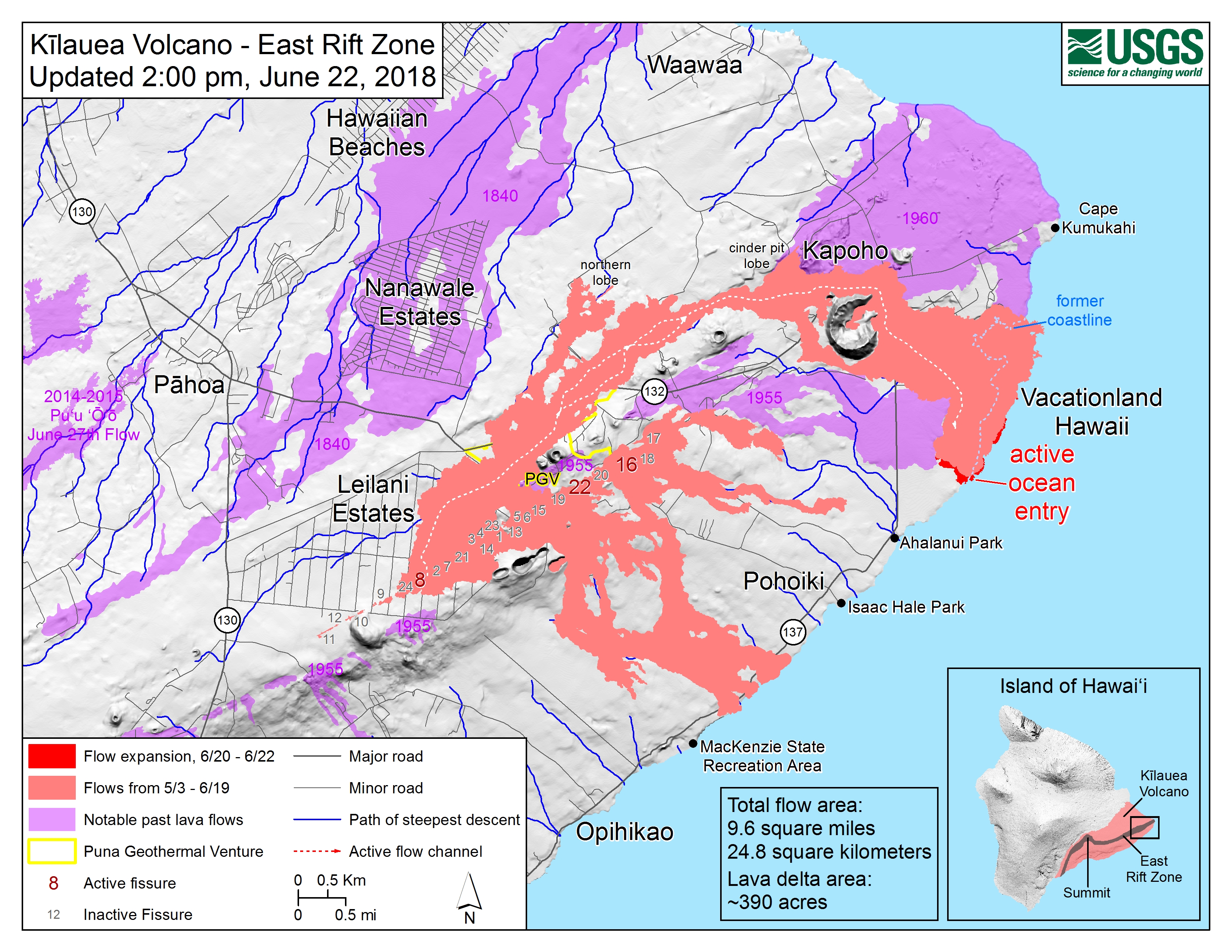
USGS Lower East Rift Zone Maps

Science And Info Around the Web
- Erik Klemetti, Rocky Planet Blog, “Just How Big Is the Kilauea Eruption?” Putting this eruption in historical context, with photos and figures.
- Weatherboy: “Rare-Look: Hydrochloric Acid Clouds”
- This isn’t directly Kilauea-related, but it looks useful enough that it’s worth mentioning: “New Online Toolbox Helps Parents, Communities Keep Children Safe In Disasters”
Hawaii County Fire Dept LERZ Overflight
HI Civil Defense just posted a new album from HCFD: 63 photos/videos from June 17. A few days old, but I love whatever camera they’re using.
Black sand beaches:
Notice the tephra on the roofs of houses:
Don’t cook the skids:
A familiar sight in Hawaii, but it used to be nearer to Pu’u O’o:
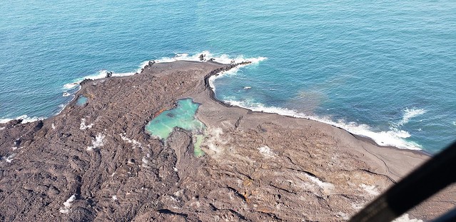
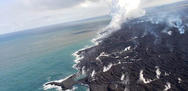
“Upwelling” patch showing where lava is on ocean floor:
From Local News Outlets
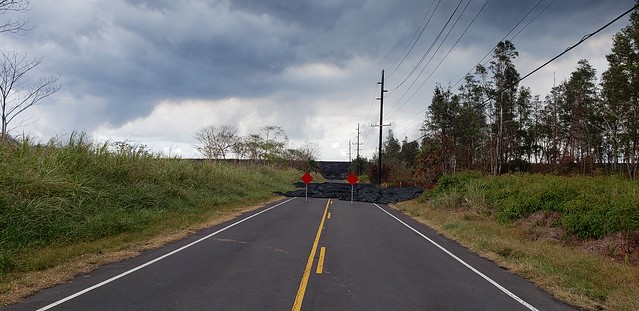
The official tally of homes lost is 614 for the moment (reported in those “rolling updates” articles that are mostly the same day-to-day)
- HCB: Their Lava Livestream has relocated to the coast north of Kapoho.
- HTH: “Guardsman reflects on time spent in eruption zone” – Major Jeff Hickman has been a steady presence for the first two months of this eruption
- HTH: “Mauna Loa alert level lowered”
- HSA: “Lava on Moku Street in Leilani Estates, Thursday, June 21” – Photos and video
- HSA: “Fines and penalties grow for Hawaii island tourists and residents found in restricted areas”
- BIN: “Free Legal Assistance for Hawai’i Island Disaster Survivors”
- HSA: “Hawaii County police nab squatter in unfinished Leilani Estates home”
- HNN: “Final touches being put on community-funded tiny homes for evacuees”
- HNN: “Groups rescue more than 250 animals from lava-impacted communities”
- HNN: “Meet the ‘Bodacious Women’ Who have come together to help lava evacuees”
- HTH: “Police: Puna man lost in evacuation zone”
- HTH: “Salary Commission postpones raises as Kim seeks budget advice”
Moment of Aloha
- Dispatches from the Volcano digs into the Hawaiian language today
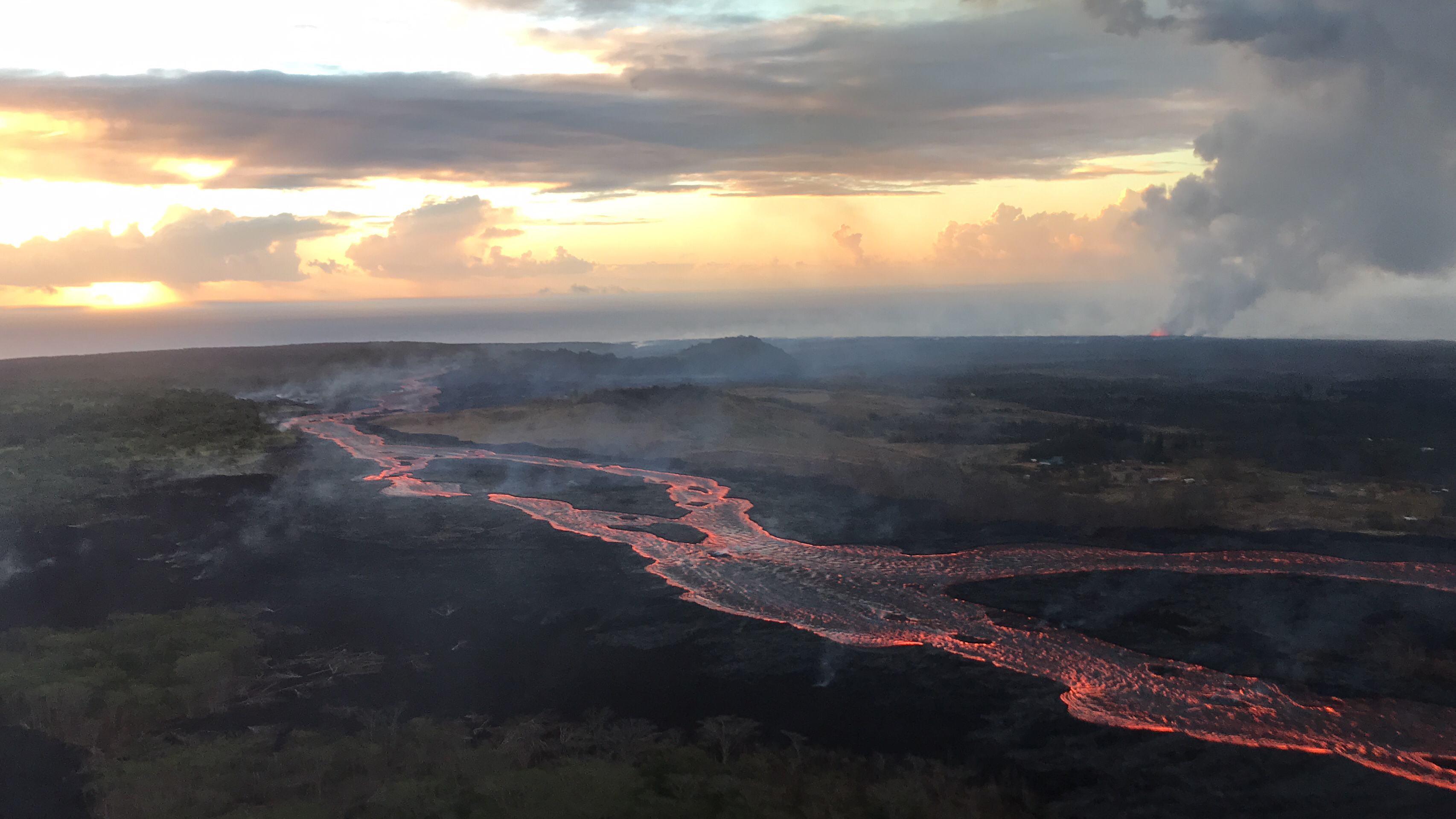
Overflights from Mick Kalber
I missed yesterday’s. It’s too impressive to skip— and a great view of the upwelling process offshore at the 2:10 mark.
June 22: The colors in this are beautiful (and there’s rainbows) but this one’s more atmopsheric than detailed. That said: 1:55 really good view of Kapoho Crater and what Green Lake looks like now.
Here’s Mick’s notes for this flight Also, Bruce Omori posted still photos from this overflight on the Lava Update blog, including one glimpse of glowing Fissure 22 (which we got to know so well during the Lava Rooster Livestream).
Other Photographers & Social Media
#LeilaniEstatesEruption #KilaueaVolcano UPDATE: New video from #KalapanaCulturalTours as USGS reports lava delta filling what was once #KapohoBay is now about 370 acres & has reached areas where the water is nearly 200 feet deep! https://t.co/Se7DnGLWeJ @HawaiiNewsNow #HINews pic.twitter.com/tdM7AbdnFW
— Mileka Lincoln (@MilekaLincoln) June 22, 2018
#LeilaniEstatesEruption #KilaueaVolcano UPDATE: A pueo flies over the #Fissure8 fountain in #LeilaniEstates in this beautiful capture by Nohea St resident Melvin Vargas as USGS reports lava fountaining from the spatter cone continues https://t.co/gMJF9lgJ3e @HawaiiNewsNow #HINews pic.twitter.com/v71k8pfV1K
— Mileka Lincoln (@MilekaLincoln) June 22, 2018
Wow.
This is looking directly into an inactive lava fissure inside #LeilaniEstates. #KilaueaEruption #Hawaii https://t.co/tE4HfLkaVG pic.twitter.com/5ey9Xq5deI
— Anthony Quintano (@AnthonyQuintano) June 22, 2018
It's hard to have that #FridayFeeling with so much loss & despair among the ruins of #LeilaniEstates caused by the #KilaueaEruption. We hope these people that lost or are losing their homes find peace and comfort soon. pic.twitter.com/ohVTbOYaKm
— the Weatherboy (@theWeatherboy) June 22, 2018
See it?
Daytime view of #KilaueaEruption from just outside of HiloBay. pic.twitter.com/syZA5K7hGr— the Weatherboy (@theWeatherboy) June 22, 2018
And a final thought…
Tay Austin has been listening to the Hawaii County disaster coordination radio channel since the beginning of the eruption.
I wish you could hear the voices of those who fly the drones. They truly do use every bit of skill they have to get the info they are asked to obtain, but there's also a humble solemness for the devastation around them. Sometimes I think even they are awed by what they see.
— Tay Austin (@Jasamsdestiny) June 23, 2018