
Link: Full audio for Tuesday, June 19 USGS media conference call
- USGS Eruption update: Status quo continues for summit explosions and Fissure 8.
- NWS: Tradewinds return Thurs eve/Fri, vog winds in meantime.
- NWP tells about places that ARE open, park-related activities.
- Question & Answer session…
Summary of questions and answers…
- Cause of daily explosions? A: “The explosion is actually more or less a by-product of the collapse of the plug that’s on top of what was the lava lake surface.” Rubble from collapse is sinking/slipping downward, and the magma column below that is also sinking.
- Will ash emissions continue to diminish in size? A: Maybe. As top of magma drops, [gases from it?] may be finding it harder to reach surface through rubble pile.
- What do these daily explosions mean for the residents of the Big Island? Answer: These explosions are not like normal earthquakes; the shaking wavelengths are longer. Therefore people won’t feel them as strongly as real EQs.
- [Person asks series of questions, mostly answered by Q1 and Q3. Also: Is groundwater still a factor in these explosions? with the usual “Maybe.”]
- Internet rumor that a public viewing area is being set up? A: Ask Civil Defense.
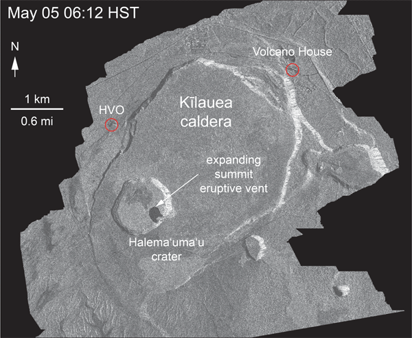
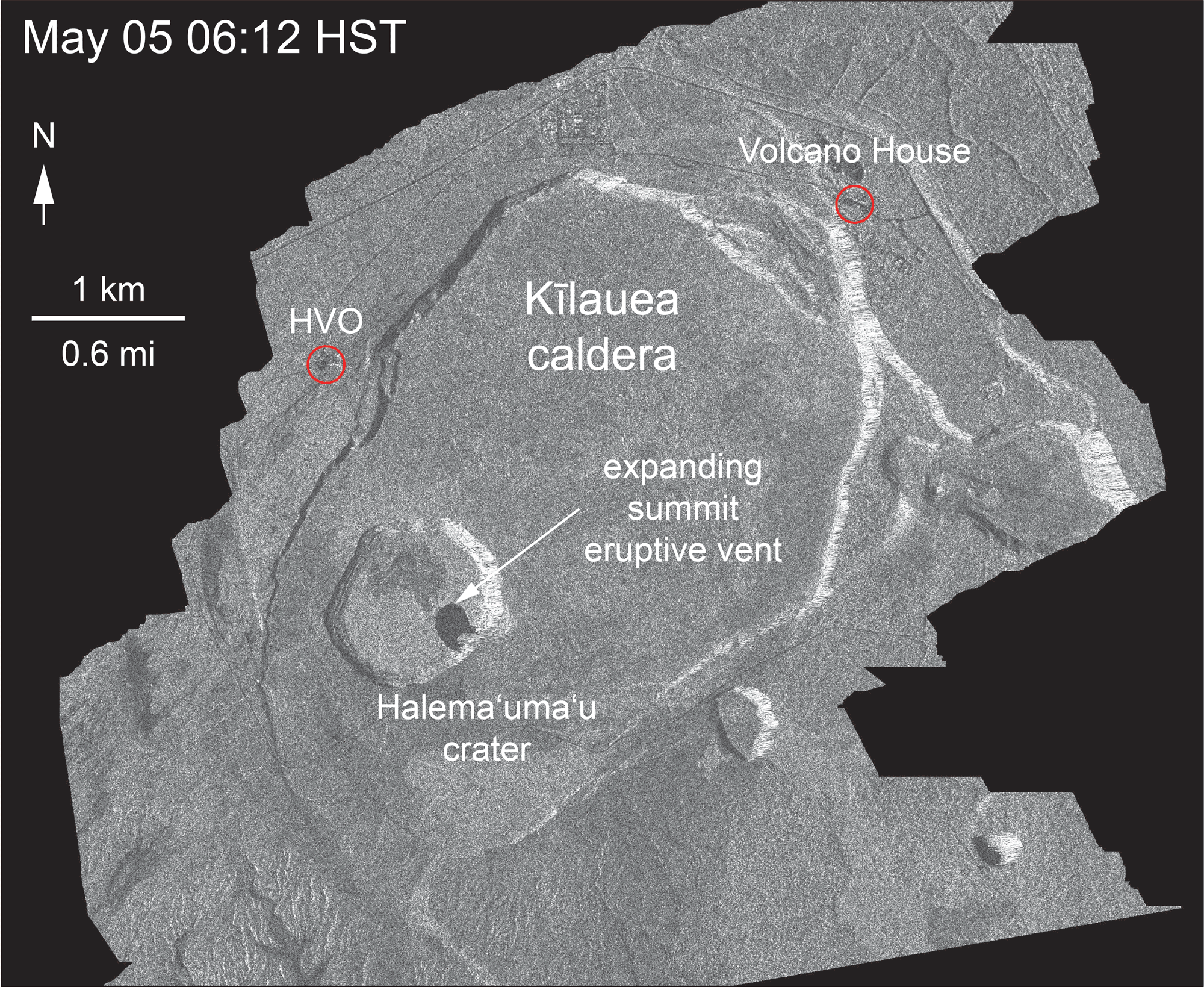
- Geeking about satellite radar animation. A: Halema’uma’u deformation not extending beyond Kilauea Caldera bounding faults [which are apparently not entirely identical to the present shape of the caldera?]
- Has lava that drained from summit gone all the way down ERZ? Is it erupting from F8? Could it come back? A: Maybe. Or maybe it’s getting stored partway down. Or maybe it’s backed up behind Pu’u O’o magma.
- Where are we in the eruption sequence? A: Don’t know, and it may not even follow 1955/1960, since summit’s behaving differently.
Complete transcription
- Moderator/Host: Leslie Gordon, USGS Public Affairs
- Weston Thelen, Seismologist, USGS/CVO
- John Bravender, Meteorologist NWS
- Becky Schwab, Hawaii Volcanoes National Park
Leslie Gordon notes they’re going to change these conference calls to Monday and Thursday, since participation has dropped off.
[Unfortunately this time the sacrificial victim, er, geologist on duty tended to meander, not helped by media cramming two (or even five) questions into one.]
Updates from USGS, NWS, NPS:
[2:05] West Thelen, Seismologist, CVO: There is not much to report over the past 24 hours in either Kilauea’s Lower East Rift Zone or Kilauea’s summit area. In the Lower East Rift, Fissure 8 continues to dominate the activity with fountain heights around 150-180 feet high. Minor overflows from the flow channel occurred and continue to be a hazard. Velocities of lava within the channel were measured up to 20mph yesterday. Flows continue to feed a single ocean entry where a laze plume is being generated. Areas near Fissures 16, 18, also had minor amounts of activity.
At the summit of Kilauea, strong seismicity preceded a minor explosion at 5:05am local time. Despite an energy release equivalent to a magnitude 5.3 earthquake, the ash cloud was minor. This continues a trend of lesser and lesser ash emissions that are associated with these types of explosions. Deflation in the summit continues, and large blocks in the Kilauea caldera are continuing to slump. At the time of this call, seismic activity in the summit [is low? I think he was reading and dropped a phrase]—based on prior activity we expect the number of felt earthquakes to increase and another minor explosion to occur within hours to a day of when seismic activity starts to ramp up again.
[3:50] John Bravender, meteorologist, NWS: [Summary: Weather = dry, stable. Light E to SE winds tonight through Thurdsay. Thursday night into Friday, stronger NE tradewinds return, chance of heavy rain increases.]
[5:05] Becky Schwab, public information officer, Hawaii Volcanoes National Park: Ok. So, we are on day 40 of park closure. However, our Kahuku Unit is open 5 days a week, Wednesday through Sunday 9am to 3pm. We also have park rangers at the Volcano Art Center’s Niaulani Campus in Volcano Village. And they’re there from 9am to 5pm daily. We also have free After Dark Near the Park events at the Volcano Art Center. The next one is Tuesday, June 26 at 7pm. We’ll be talking all about the Hawaiian Monk Seal. And on our website, you can find more information about park-related activities that visitors can still do.
Questions & Answers
[8:05] What’s causing daily summit explosions? What have you learned about the cyclical pattern?
West Thelen: Yeah, I think that it’s interesting that these explosive events have been very periodic in time, right around 24 hours recently. And they’ve been not only regular in time, but regular in the way that they build up. So the earthquakes have been getting more numerous and stronger before these explosions happen. We can see in the instruments that are on the floor of the caldera that the caldera [!!!] is actually sinking faster prior to these Type— these events [he was probably going to say Type A].
And really what we think is happening is that the explosion is actually more or less a by-product of the collapse of the plug that’s on top of what was the lava lake surface. So as the lava lake drained down into the conduit, now you’ve got a big rubble pile above that magma column. And as deflation continues, that column of material on top of the magma column is actually sinking in as well. And that’s probably the trigger for what’s ultimately causing the explosions at the surface.
[10:20] Will ash explosions continue to diminish?
West Thelen: I’m not sure that we have a really good model for what we should expect to see in this type of situation. There are cases where— There’s certain models that we have in our head for why this would make sense, one of which is that the magma column, or basically the top of where the magma is within the volcano, is getting deeper and deeper, and potentially it’s having a harder and harder time getting through that material up to the surface. And that could be a reason, a really straghtforward and simple way to possibly explain why these events are getting smaller and smaller at the surface.
Because what’s interesting is that, as far as energy release goes, and as far as we can see on instruments that measure either the tilt of the ground or the change in position of a specific point, from the— from that standpoint, all these explosions have been really, really similar. So there’s a lot of similarity in the geophysics of the explosion, but there’s really not a whole lot going on that’s coming out at the surface and the top. So maybe the easiest way that is this, as the magma column gets deeper, things are having a harder time getting through that.
…This dataset will definitely be something that we’ll be chewing on for a while. And the details of these really arm-wavy models that we’re coming up with to explain the activity… the details will come out in the subsequent studies in the next years to even decades or so.
[13:05] (HNN) How many days in a row have there been EQ > M5? What does this mean for residents of Big Island? (mentions that people don’t always feel them)
Weston: I don’t have an actual number for you in terms of how many days in a row we’ve had …one of these explosion type events. What I can tell you is that thus far we’ve recorded 30 of these events. They’re very clear in the geophysics, so they’re very easy for us to track. And so, yeah, we’re up to 30 now. Recently they’ve been around every 24 hours, so I’m looking at a plot now, and seeing that June 4 that there was more than a day break between subsequent explosions.
(asks for second question to be repeated)
That’s a great question. So these explosions have energy release that’s equivalent to a magnitude 5.3 or somewhere in that range. I use that verbiage because they’re not really earthquakes. They’re these big collapse events. And they don’t really have the same really fast ground motions that people typically feel if they were to feel a magnitude 5, let’s say, off the south coast of Hawai’i. So, yeah, you’re right, people aren’t feeling these explosions which have an energy release like a magnitude 5.3 the same as they would in normal earthquakes. And part of that is because of the way that the energy is being released. These waves have very long wavelengths and so in fact the waves take almost 20 seconds for someone to actually get— for that wave to kind of pass, the entire wave to pass by you. And that’s generally too long to be able to feel. Most people start to feel ground shaking when waves are going at about 1 hertz (or 1 cycle per second) or higher. So especially when you get up to 20 hertz, 20 cycles per second, that’s when it starts to feel like a truck hit your house or something like that, particularly around magnitude 4. So we are seeing some of that high-frequency energy, that energy that people more often feel, but it’s not the same energy release as a magnitude 5; it’s more like the energy release of a magnitude 4 that people are feeling.
Q: 30 events? Are you referring to total number of these explosive events at the summit, with the ash plumes?
Weston: Yes, that’s the number of these types of events that are very easy for us to determine from the geophysics. They have a nice increase in earthquake rate and size, they have a really nice tilt signal that jumps up, and so the reason we’re able to track these so well is because they have these really obvious signals in the geophysics and we don’t need to necessarily have daylight to know that they happen. There were some other events in the past and there are some events that are happening now from time to time that are putting up a combination of either dust or ash, that are more surface events. So that would be a large block slumping, or a rockfall, particularly when the crater was forming and deepening and getting wider, we were seeing a lot of those shallower events that were strung together that were creating fairly sizable ash plumes. But we have a harder time counting those throughout the day because we can only see them really during the day. We can only notice these ash plumes during the day. And we haven’t gone back and looked at the seismic or the GPS signals to see if we can track those sort of more shallow than… more consistently through time.
Followup: There’s been 30 of these explosive events?
A: Yes.
Followup: Is groundwater causing them? Or something else?
A: Pretty hot debate going on right now as to whether there is or is not groundwater, what the relative contributions of magma vs. groundwater are in the current explosions. And what I can tell you is that there’s evidence for magmatic contributions, and there’s evidence for groundwater contributions. [Although in a recent call Brian Shiro— I think?— said they’d decided groundwater wasn’t “driving” these.] The details of that will be worked out down the line.
Followup: If groundwater’s not the cause, is it pressure generated by being “capped”?
A: Causing the explosions? It’s more… The system isn’t really… it’s more of a collapse mechanism that we prefer for these types of explosions. There is some kind of pressurization that goes on between the explosions, which is why we see the….. …. … increase in earthquakes. [although it’s also deflating?] I should back up a little and say there is… there’s probably pressurization in the gases that are coming out [of the magma?] and filling cracks that’s sort of helping the earthquakes occur, but the earthquakes are occurring because the whole area is collapsing down. So there is some pressurization but it’s also there’s collapses going on at the same time. So it’s sort of a delicate balance based on where you are between these explosions.
Followup: So collapse is causing explosions?
A: Yes. [which was said 10 minutes ago.]
NEW QUESTION FROM SOMEBODY ELSE FINALLY.
Q: I heard [on a Facebook group] there’s going to be a public viewing platform. When?
Leslie Gordon, USGS (Public affairs): We know very little about that, probably less than you already know. And I would recommend talking to Hawai’i County Civil Defense, who can tell you more about what’s going on. We’ve not been involved.
West Thelen: We have lots of different ways that we can look at how the caldera is deforming, and how it’s collapsing. And one way we can look at that is by satellite, with something called INSAR. And what we see with that particular dataset is that there’s an area that is encompassed within the caldera-bounding faults. Those are the really dramatic faults that make up the edges of Kilauea caldera. One of those caldera-bounding faults, an example of that would be what’s right underneath the overlook crater. [wait… is that the boundary of the caldera?] And what we see in this INSAR analysis from satellites is that that area of really strong deformation, really strong collapse is contained entirely within the caldera. It is not going outside of those really dramatic large faults on the edges of the caldera. So right now, based on the data that we have in hand, we think that the collapse is really going to be confined to that area. And again, that’s what the information that we have and the measurements that we’re making is that there’s this large area [of…?] that takes up almost the entire Kilauea Caldera, that does not include the northern margin yet, but that whole area is encompassed, but it’s not really traveling outside those caldera bounding faults.

[26:00] Q: [Longwinded question asking them to talk about the plumbing system, after the questioner talks about the plumbing system. Also, has the lava that’s drained from the lava lake gone all the way down the East Rift Zone to erupt from F8, and could it return?]
Weston: Well, what we can say is that we are seeing— our instruments that are on the caldera dropped, and our best model for that includes that magma’s leaving the system and heading out to the East Rift Zone. Thus far we’ve lost 267 million cubic meters to this collapse. And that breaks down most recently to about 14 million cubic meters per day. So that is a huge amount of magma that is leaving the system. Whether or not it’s making it all the way to the Lower East Rift Zone right now is another one of those details that we’re trying to work out right now. We’ve got lots of different angles that we’re working on. And what we know is that the magmas that are coming, that the lavas that are coming out of fissure 8 in the Lower East Rift Zone look a lot like Pu’u O’o. And we’re trying to kind of piece together the details right now of whether or not there’s space in that analysis to also allow for things that have come from the summit to be erupted there yet or not. It could be that it’s going into the East Rift Zone and being stored in a certain area. It could be that it’s going down the East Rift Zone and is backed up behind things that haven’t quite been erupted down at fissure 8 yet. [Translation: “Magma from the lava lake may be backed up behind magma from Pu’u O’o.”] You know, more or less they’ve gotten in line to head downrift. But we are still working out the details of exactly how far down that summit stuff has made it so far.
Q: [Where are we in the overall eruption sequence, based on past eruptions (1955, 1960)?]
A: I think that there’s enough variations in different eruptions and different scenarios that it’s very hard for us to put our finger on where we are in an eruption cycle. We just haven’t seen enough of these cycles at Kilauea yet. You know, we did see an eruption down here in 1955; we saw an eruption in 1960; we saw that those lasted anywhere from weeks to a couple of months, and that’s sort of what we have to go on. And so until we sort of surpass that time frame then we sort of suspect that, you know, basically guesses as to what might happen down there come from the 1955 and 1960 eruption. And so… then again, these are different. The setup in the summit in particular is different than it was back then, so it’s not clear if that’s a great analogue to this or not.