Today’s eruption summary
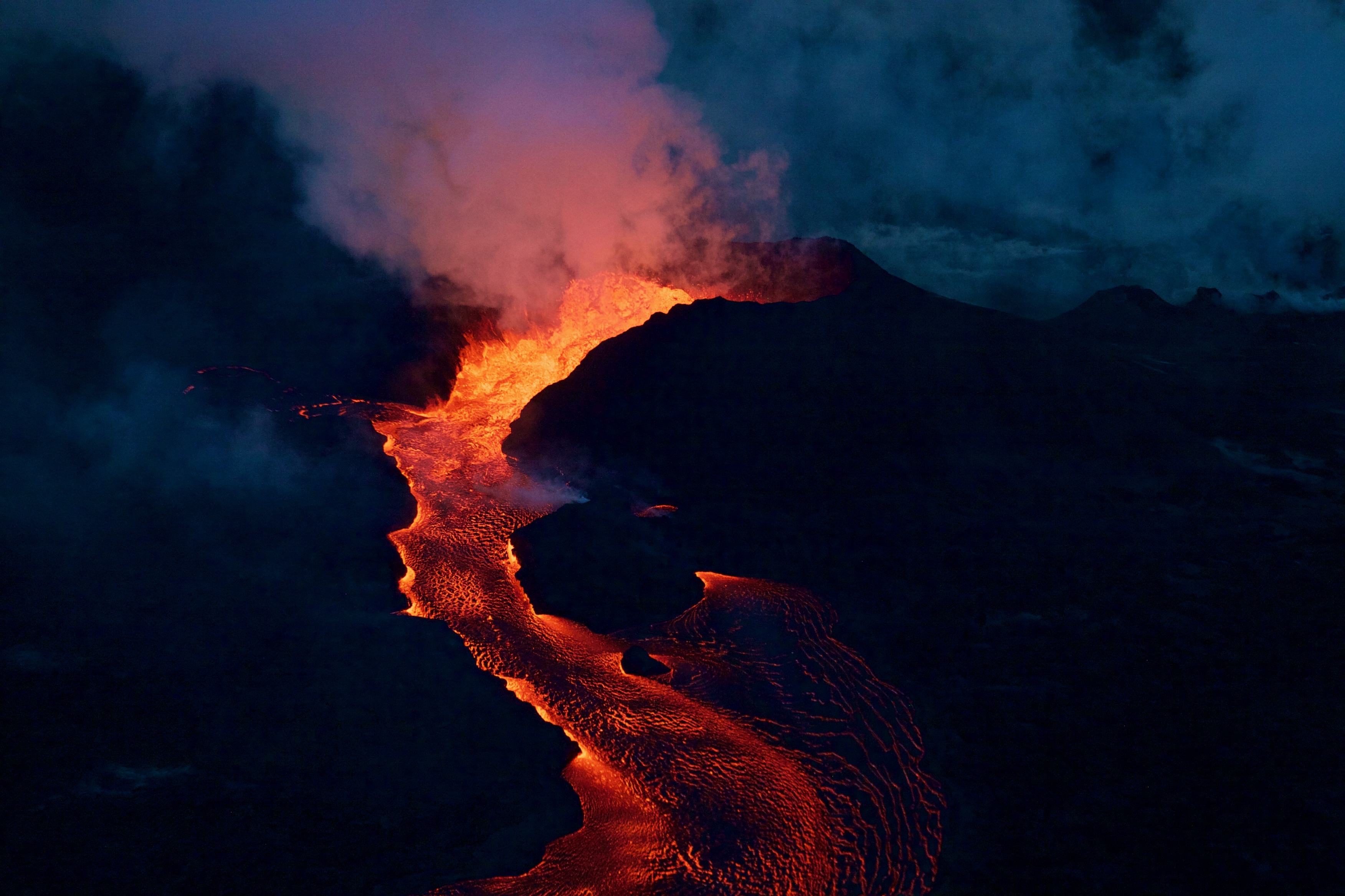
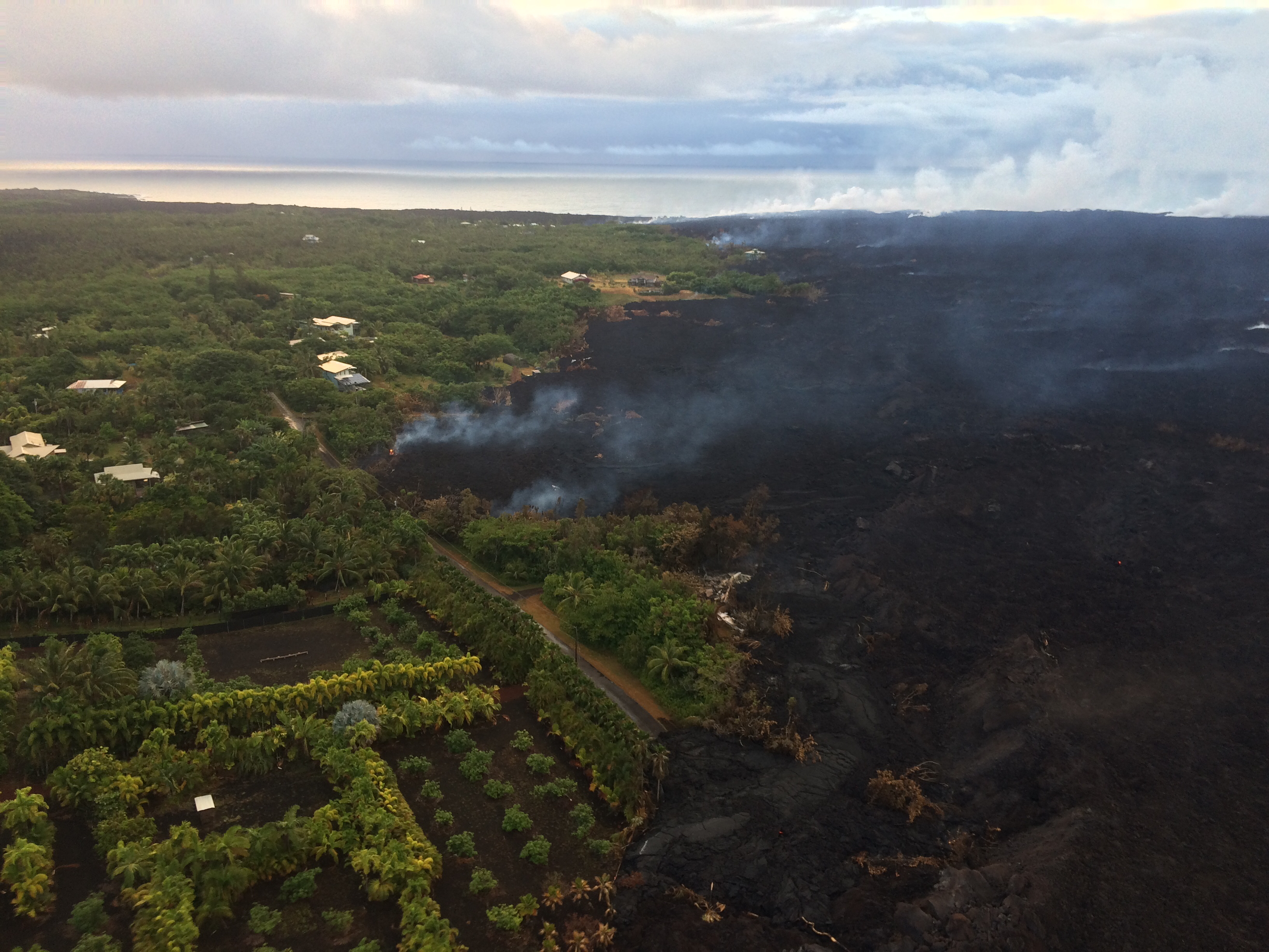
Exactly 8 weeks after the Lower East Rift Zone eruption began in Leilani Estates on May 3, Fissure 8 continues to gush unabated. Its fountains are contained within its 55-meter (180 ft) cone, and this morning’s overflight showed no active overflows.
#LeilaniEstatesEruption #KilaueaVolcano LATEST: More unbelievable video of “lava boats” from #IkaikaMarzo who captured how fast the flow or river of lava produced by #Fissure8 in #LeilaniEstates is moving; USGS daily update 👉🏽 https://t.co/QuqIM63MCJ @HawaiiNewsNow #HINews pic.twitter.com/Hgctfp2IEC
— Mileka Lincoln (@MilekaLincoln) June 29, 2018
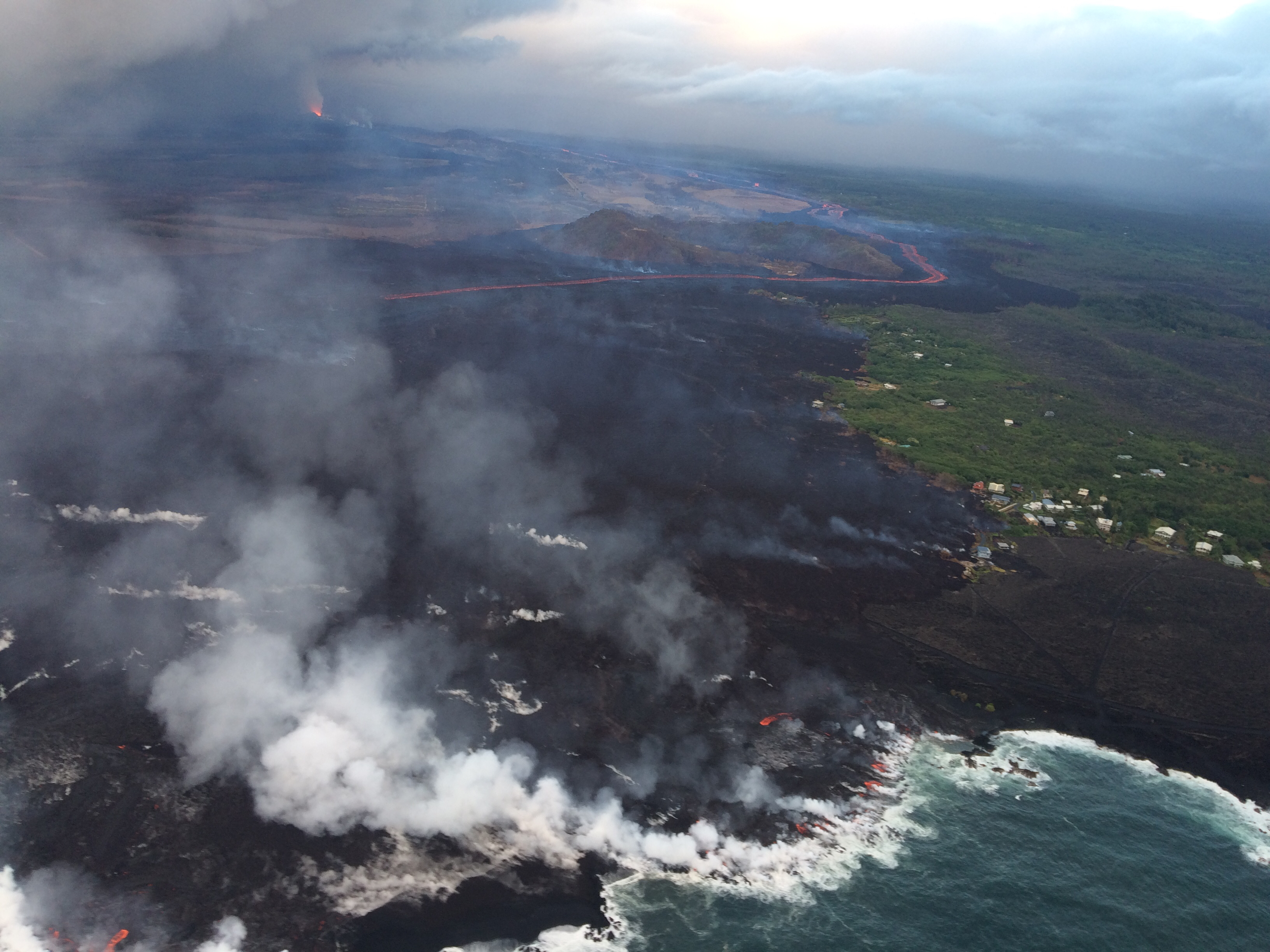
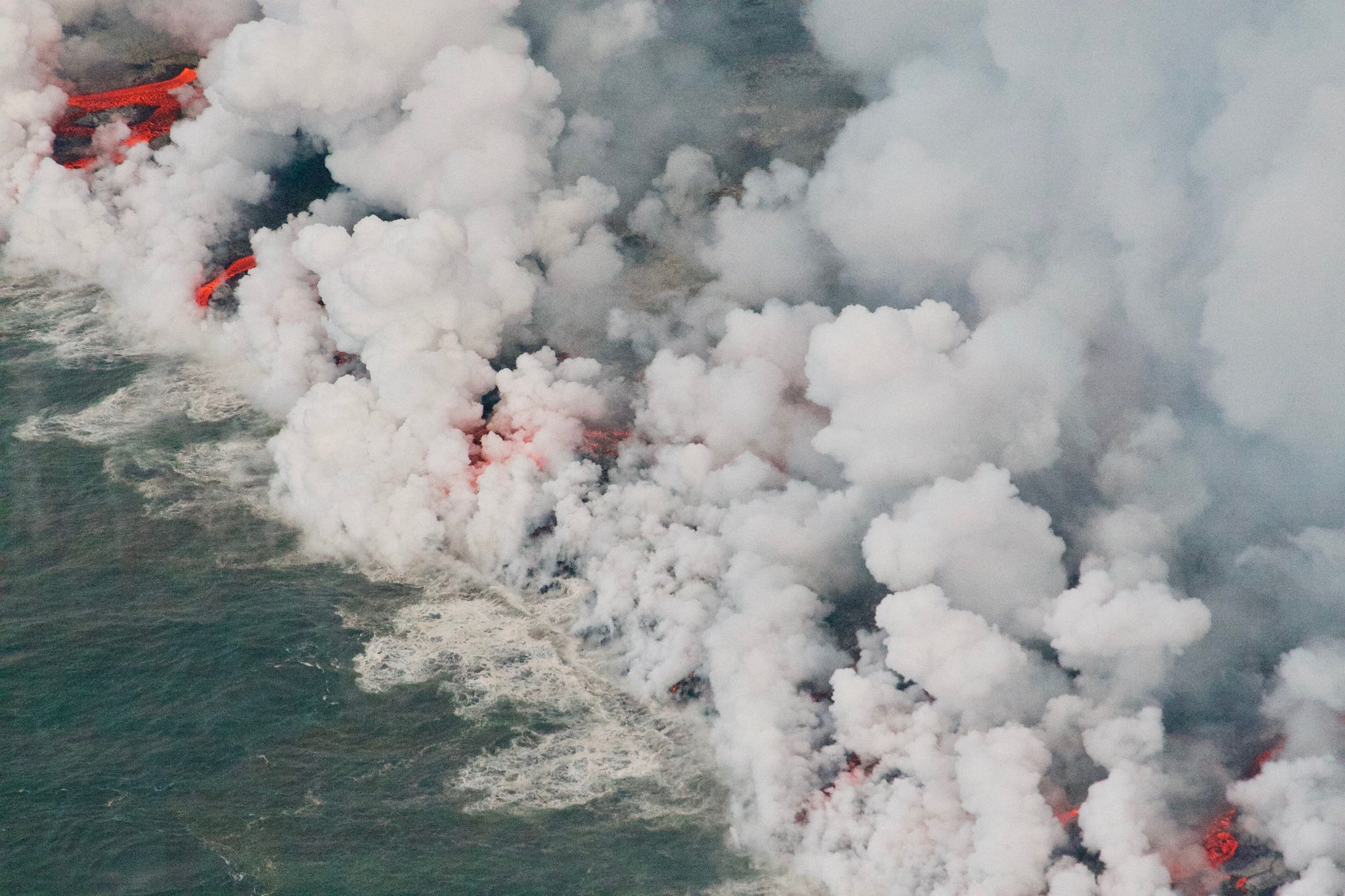
For the past day or so, the lava river has crusted over on the last half mile to the ocean. This has allowed lava seeps, described by Steve Brantley in his Tuesday evening talk, to creep into still-molten earlier flows on the northern side of the lava delta. This “lava seepage” is oozing into the ocean along a broad front, encroaching onto what’s left of Kapoho Beach Lots on the northern edge of the flow:
At Kilauea’s summit, the most recent collapse explosion occurred at 4:49am this morning, sending up an ash-poor plume about 1000 feet, with the energy release of a 5.3 earthquake. The sides of Halema’uma’u continue to collapse inward and downwards, especially during each explosive event.
Increased seismicity in the hours leading up to each explosion, up to 25-35 small earthquakes an hour, is wearing on the nerves of nearby Volcano Village. The USGS is meeting with them tonight to talk about the ongoing earthquakes, and released an excellent FAQ today: “Frequently Asked Questions About Kilauea Volcano’s Summit Earthquakes.”
Local News Outlets Given Brief Tour of Summit
The big news today is that the National Park Service and USGS arranged a brief escorted tour for local news media to the rim of Kilauea Caldera, which has been closed to visitors for 49 days. There was also a half hour press briefing.
So today there’s suddenly a lot more videos and views of what the caldera looks like:
#LeilaniEstatesEruption #KilaueaVolcano UPDATE: @Volcanoes_NPS has been closed 49 days. Ongoing earthquakes & collapse explosions are some of the hazards keeping it shutdown. Officials estimate $20 million in losses to local economy https://t.co/Zd2VMCiLW6 @HawaiiNewsNow #HINews pic.twitter.com/dl1o9GpwCP
— Mileka Lincoln (@MilekaLincoln) June 29, 2018
In fact, I’m going to put the news media links before the science segment of today’s post. Boldfaced articles include quotes, videos, and/or photos from the media summit tour.
From Local News Outlets
- BigIslandVideoNews posted the entire half hour press briefing, overlaying it with other video footage taken by their cameraman. But it’s quicker to read news articles with a few highlights:
- HSA: “Halemaumau Crater at Kilauea is double former size, scientists say” Includes video clip.
- HNN: “Unprecedented. Staggering. Profound. That’s how scientists describe the last 2 months at the summit.“ Turn down sound to get past ad and watch the video at the top of this article.
- HSA (Photos): “Tour of Hawa’i Volcanoes National Park, June 28”
- KITV (Video segment): “Kilauea eruption changes much: landscape, park operation, science’s understanding“ – note that the video clips of large ash explosions in this segment are from May; recent explosions are ash-poor.
- HNN: “The incredible scope of the Big Island eruptions, a disaster with no end in sight”
- HSA: “Puna residents complain of squatters, looters and thieves”
- HSA: “Two more cited for loitering in Kilauea eruption area”
- HTH: “County mulls options for housing of lava evacuees as grassroots efforts continue”
- BIN: “Senate Passes Hirono Provision to Help Volcano-Impacted Farmers”
- HNN: “Check out this monster ‘lava boat’ floating in lava rapids'” – Ikaika Marzo claims this chunk was about 20×20 feet.
#LeilaniEstatesEruption #KilaueaVolcano UPDATE: Astounding changes to Halemaʻumaʻu Crater from our vantage point at the Jaggar Museum and Overlook — which remains shutdown along with most of @Volcanoes_NPS after closing 49 days ago https://t.co/yfzqmItHRE @HawaiiNewsNow #HINews pic.twitter.com/TtxZdDl5ia
— Mileka Lincoln (@MilekaLincoln) June 28, 2018
Okay, back to our regularly scheduled science geeking.
USGS Q&A on social media
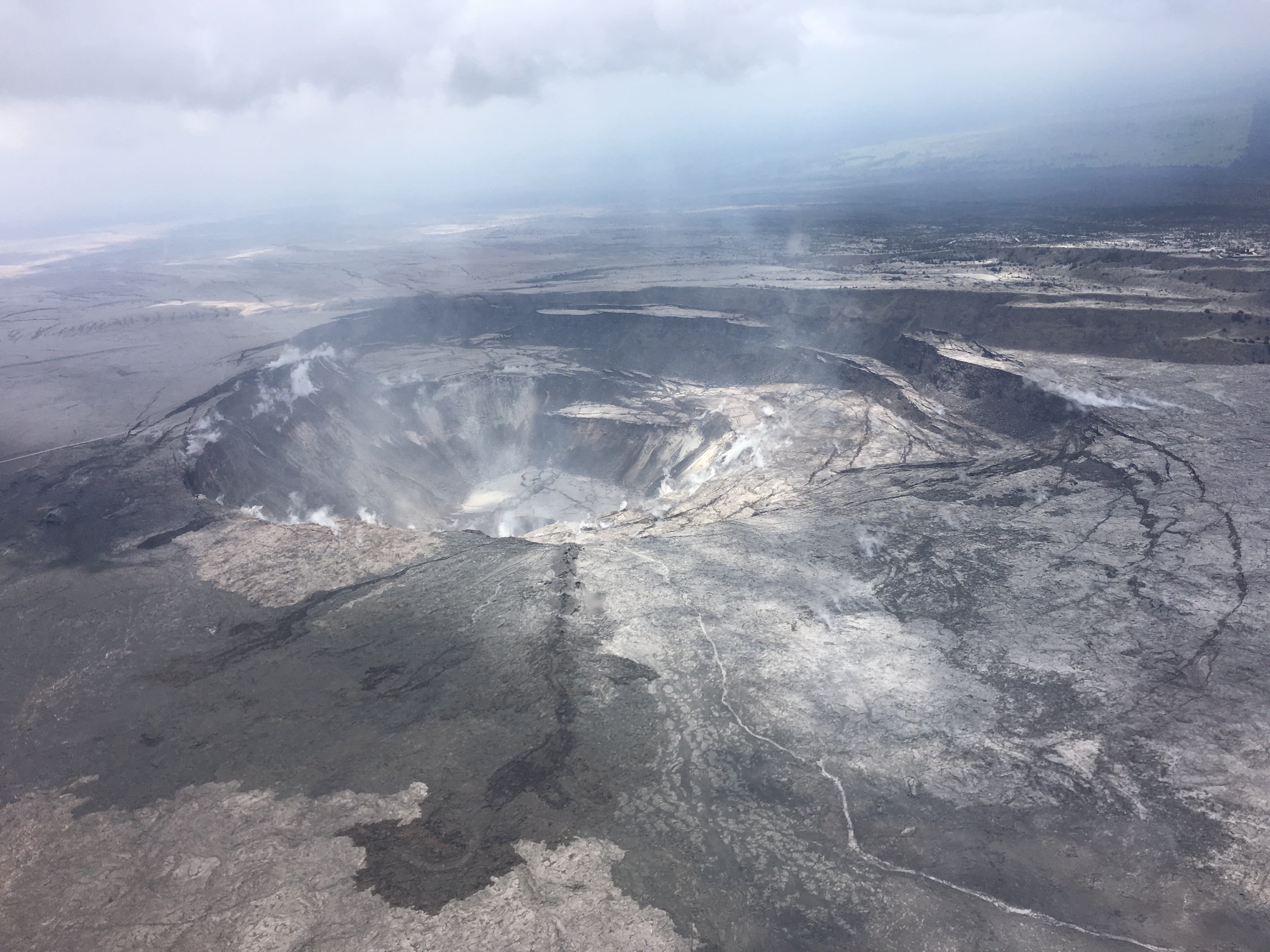
Q: Regarding the above photo, how much of the original floor of Halema’uma’u remains?
USGS: There is a bit of that floor left — maybe 1/2 of 1/3 of the original floor, and that has subsided as a block by hundreds of meters. It’s the flattish piece that’s at the center of the pit.
Q: Could Halema’uma’u Crater double in size?
USGS: It has basically already done that, but it is possible for those cracks and scarps on the right side of the photo [above] to become new crater walls if the collapse continues.
Q: What’s the probability of subsidence affecting Volcano Village?
USGS: The rim of the caldera is about 1 mi from the Village, and the area of active cracking and slumping is even farther away. For the moment, we’re not concerned about subsidence that far away.

Comment: [Prediction of complete caldera collapse.]
USGS: We’re watching that process in slow motion. Based upon artistic renderings from the 1800s, there were deeper sections within the known caldera. It’s unlikely the entire caldera bounding fault area will drop down. We are seeing all the current downward movement happening from the area surrounding and to the east of Halema’uma’u. The northern end of the caldera is not involved at this time.
[To a similar comment] The collapse so far is centered on Halema`uma`u and it’s east rim, which is more or less directly above the center of the shallower of the two magma reservoirs beneath the summit.
[Returning to the Lower East Rift Zone]
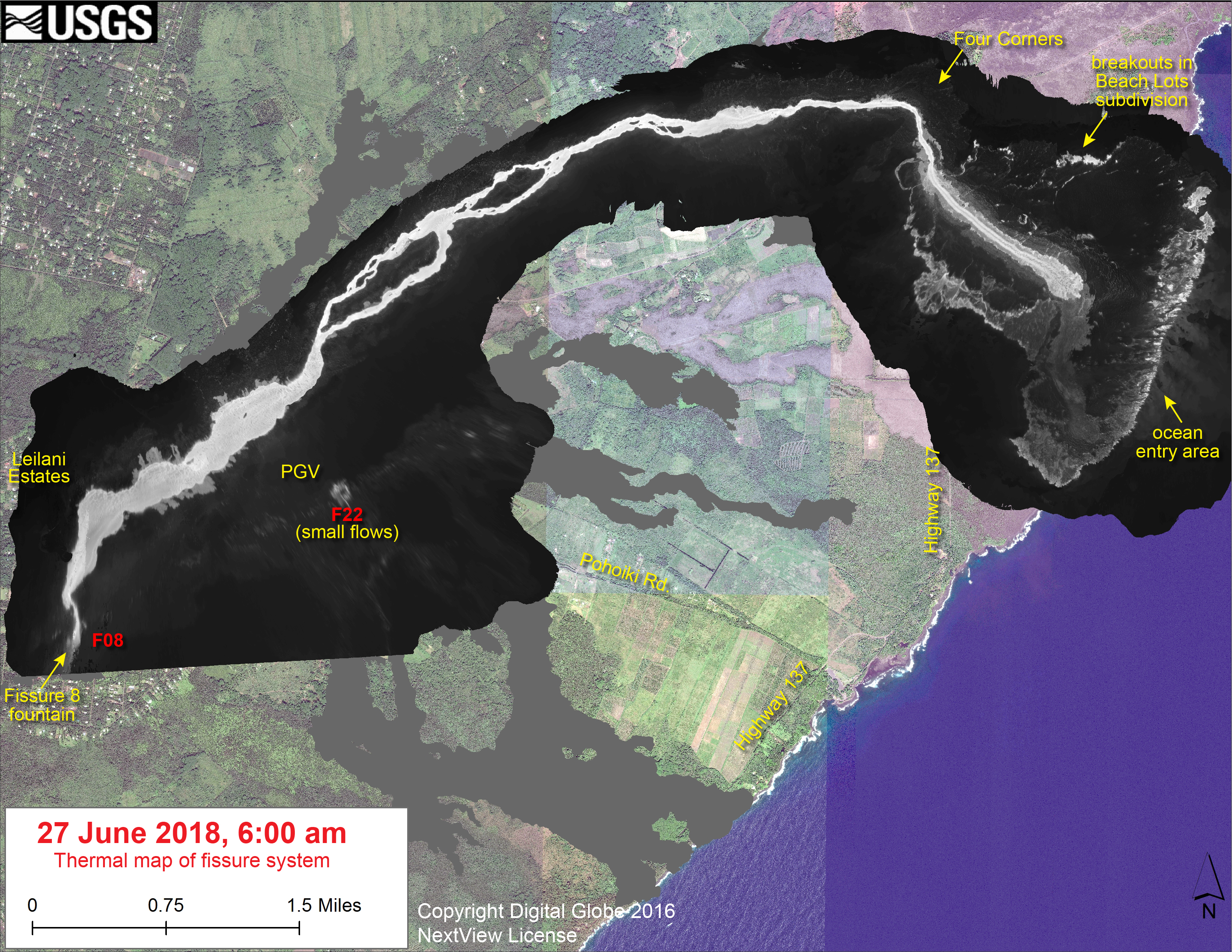
Q: Latest thermal map shows hot channel, then cooler area, then hot ocean entry. How can lava temperature decrease and then increase again? Is there a lava tube?
USGS: The thermal camera is seeing the crusted surface of the active flow, not the more molten interior. It does now seem that there are small tubes feeding the active flow front, though we’re not aware of any large ones just now.
Q: What’s the difference between Pele’s hair and other kinds of volcanic glass?
USGS: The difference is mainly in the shape. Pele’s hair [look at THIS!] is long, thin strands of glass, while Pele’s tears are droplets of cooled glass.
Q: What is the speed of the lava in this video?
#LeilaniEstatesEruption #KilaueaVolcano LATEST: #IkaikaMarzo captures the phenomena that USGS has named a “lava boat”. Watch as it makes its way down the #Fissure8 lava river in Kapoho and then breaks apart 😳 https://t.co/66DxdlXUzZ @HawaiiNewsNow #HINews pic.twitter.com/bAQK1uYyJh
— Mileka Lincoln (@MilekaLincoln) June 28, 2018
USGS: To figure that out, we would need to track one of the smaller bits of the crust on the flow over a set distance, which is hard to do in this video since we don’t have any fixed scales to go by. We’ve been seeing velocities up to 8.6 m/s (19 mph) today.
TOday’s Lava Flow Map
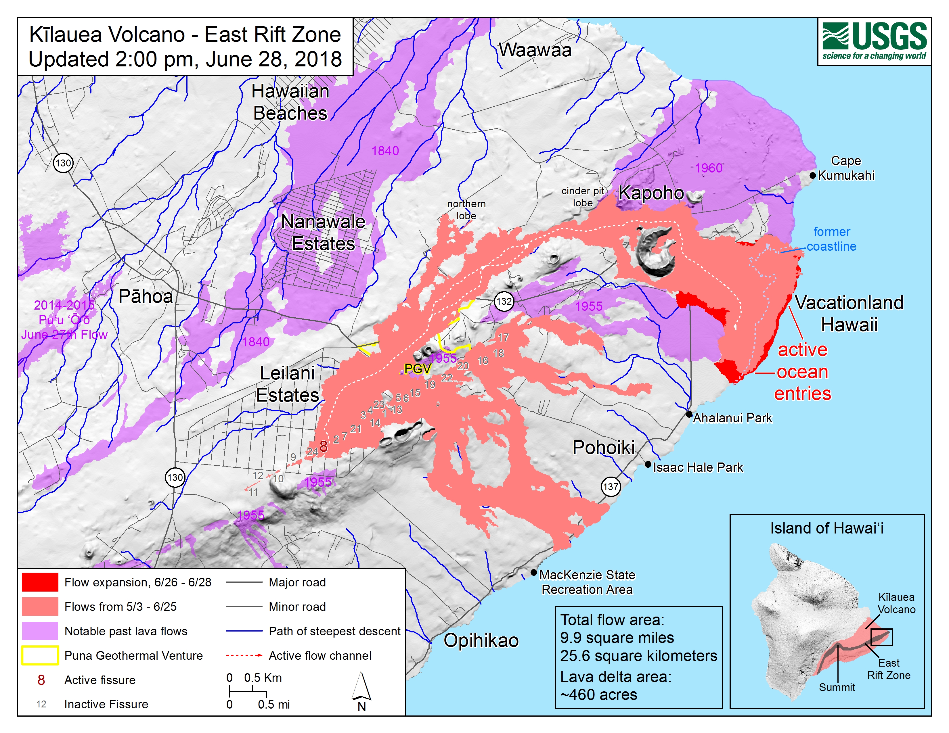
Q: How do you map lava flows?
USGS: USGS lava flow maps are created from a combination of helicopter overflights, drone imagery, satellite imagery, and on-the-ground confirmation by our scientists.
Followup: Cool! How do you use helicopters for mapping?
USGS: We have the helicopter hover and take individual GPS points over features, or we can use the helicopter to follow the edges of features and create whole GPS tracks.
Q: Are there any other volcanoes like Kilauea, with fissure eruptions in residential areas?
Probably the closest are Masaya and Nyamuragira. Piton de la Fournaise and the Galapagos Islands (like Fernandina) are similar geologically, but more sparsely populated.
Q: Okay, we don’t know when it will stop, but HOW will it stop?
USGS: We would expect a slow down, following past lower East Rift Zone eruptions. Usually those wane, and sputter a bit, and then stop. But there are relatively few examples to go off…
Q: What will be left when it’s over? Empty channel? Lava tubes? Are there features like that elsewhere on the island?
USGS: Absolutely. There are “frozen” lava channels and lava tube systems all over the islands. Mauna Ulu has an amazing set of features, which is in Hawai’i Volcanoes National Park. There are also large lava channels north of Kona that fed flows from Hualalai. Mauna Loa also has some easily accessible. There are even lava tubes near the coast that hold fresh water – and you can swim in them! Look up Queens Bath.
Q: Is there a 3D model of Kilauea’s “plumbing” system?
USGS: We have this one. It’s a cross section of the conceptual model of Kilauea’s plumbing system. H is the Halema’uma’u storage region and SC is the one below the south caldera.
Posted by USGS Volcanoes on Thursday, June 28, 2018
Q: Is the shallow chamber above sea level?
USGS: The shallow reservoir is about a mile (give or take) below the surface, so it is close to sea level in an absolute sense.
Q: So it takes more than gravity for the lava to erupt in Puna? There’s pressure above and below?
USGS: Some of the pressure comes from within the magma itself – from the formation and growth of bubbles! As it moves through the rift zone and approaches the surface at fissure 8, lithostatic pressure (supplied by overlying rock) decreases. Liquid forms of sulfur dioxide, carbon dioxide, and water are exsolved from magma (meaning, they form bubbles). The same process occurs when you open a bottle of soda – dissolved CO2 forms bubbles as soon as the confining pressure of the bottle top is released. Gas phases of these species take up more space than the liquid phase, so that provides internal pressure within the magma, which forces it through a pathway to the surface.
Geeky Discussion of “Collapse Explosions” Facebook:
Michael Ross Very interesting and thanks; I appreciate the job you’re doing here putting actual preliminary science out here to satisfy the curious – giving your preliminary thoughts in real-time on mechanisms and processes that would more normally be discussed much later in papers after careful analysis and peer review.
You seem pretty hot on the ‘piston’ model and are characterizing the events as “collapse/explosions”. What’s collapsing is pretty obvious but what exactly is exploding and why? Is it a case of ‘collapse’ motions on ?ring faults? also ‘loosening the seal’ on a partially pressurized magmatic system, allowing gasses to escape energetically at the time of the collapse event? i.e. the events are structurally driven, by stress on the faults, and not explosively driven, by overpressure and rupture? So most of that Mw5.x energy is being released tectonically, rock-against-rock, rather than explosively?
There’s a good paper on the caldera collapse at Bárdarbunga in 2014 which bears some considerable similarities to this eruption and was also modeled using a ‘piston’ mechanism:http://eprints.whiterose.ac.uk/…/Gudmundsson_et_al_2016…
USGS reply:
There are some parallels to Bardarbunga, although of course we couldn’t see what the collapse there actually looked like, since the caldera is covered by lots of ice. As for the explosions, the larger events started off that way back in mid May, and were associated with ash plumes that actually went to 30,000′ in one case. Over the ensuing weeks, especially starting in early June, the event styles transitioned from being associated with explosive bursts of ash and gas to being associated with incremental slumping of the Halema`uma`u rim and walls. The events are driven by structural changes, but the magmatic system is not pressurized (fortunately), and we’re seeing very little gas coming out anymore. So you’re right, the ~M5.3 events are like mine collapses in terms of the energy they are generating (which is also why the events are not felt across the island, despite releasing the same energy as an M5+ earthquake).
Rumor Whack-a-Mole
Regarding Fox News’ latest looney volcano “news” story about a supervolcano forming under New England, which is just as accurate as their initial “breaking news” that Oahu (!) was being evacuated due to the Kilauea eruption.
(After multiple people asked them to weigh in on the story):
USGS: Fake news. The article is about an old (Nov 2017) press release (https://news.rutgers.edu/research-news/mass-warm-rock-rising-beneath-new-england-rutgers-study-suggests…) which EXPLICITLY states the researchers found “warm rock” – not magma – and it would take millions of years to even get close to the surface. There is no supervolcano forming in New England.
From Other Scientists
Awesome volcano ocean link. https://t.co/FWVoKyhOJt
— Dr Adam Kent (@geowhateverist) June 20, 2018
Fresh lava flows from Kilauea’s Fissure 8 contribute nutrients to the ocean waters around Kapoho.
The satellite image features the distribution of nutrients, & presumed chlorophyll growth, in plumes that swirl offshore to the east.
Prevailing winds blow airborne ash to the SW. https://t.co/A3Kprq1SXW
— Dee Gardner (@glacierpique) June 29, 2018
From Hawaii Volcanoes Nat’l Park
Posted because it’s a clear view of Halema’uma’u from the Volcano House side of the caldera:
Join us for a Facebook live video feed of a press briefing at the summit at 10am HST, in about 20 minutes. Summit photo taken this morning. #kilauea #kilaueaeruption pic.twitter.com/C7AnHCial3
— Hawaii Volcanoes NPS (@Volcanoes_NPS) June 28, 2018
While they uploaded a recording of the Facebook live video, the sound quality is dodgy. The BigIslandVideoNews video I posted earlier is the same briefing (I think) with better sound.
Civil Defense Alerts
Sadly, a new line has been added to daily alerts: “Under Emergency Provisions, any looting or vandalism during an emergency is treated as a felony.” The Star-Advertiser news article I linked to above explains why.
I fear they’ll need more than verbal warnings to stop this problem.
Photographers and Social Media
Mick’s a day behind— here’s his overflight notes for this video.
#lavaflow #beforeaunrise #bigisland #Kilauea pic.twitter.com/wWlg7HqNid
— Casey McMurray (@CaseyMcMurray) June 29, 2018
Video of #kilauea #lavaflow #sunrise pic.twitter.com/7IeYzJiykG
— Casey McMurray (@CaseyMcMurray) June 29, 2018
Kilauea eruption with molten lava and papaya trees near Kapoho, Hawaii, 1960. pic.twitter.com/IKC40IkFVY
— Eye Stream (@BrianStelly_) June 29, 2018
Hawaii Volcanoes Observatory in 1951.https://t.co/XAqYNBxKuu#ThrowbackThursday pic.twitter.com/wS1mYMaMaH
— USGS (@USGS) June 28, 2018