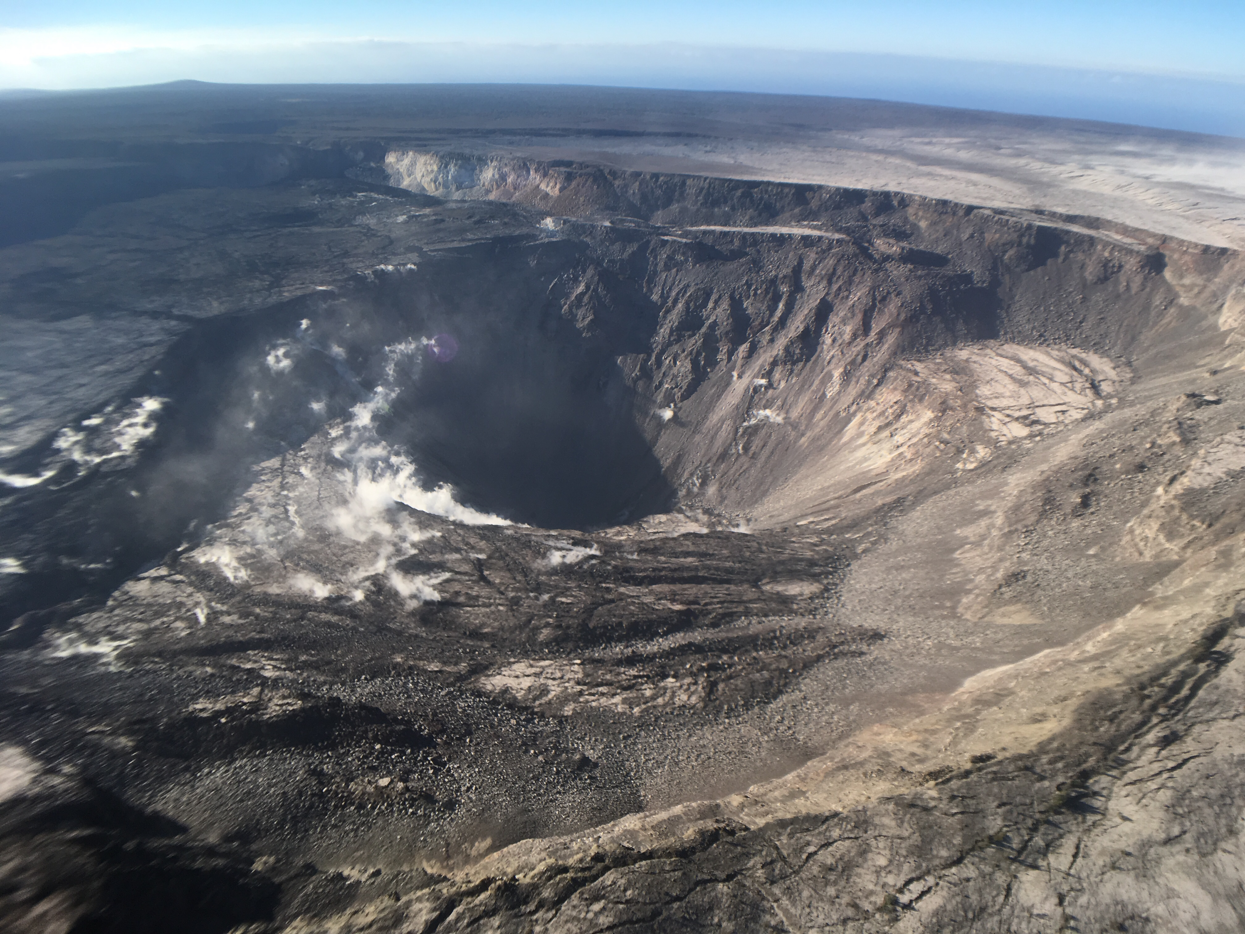
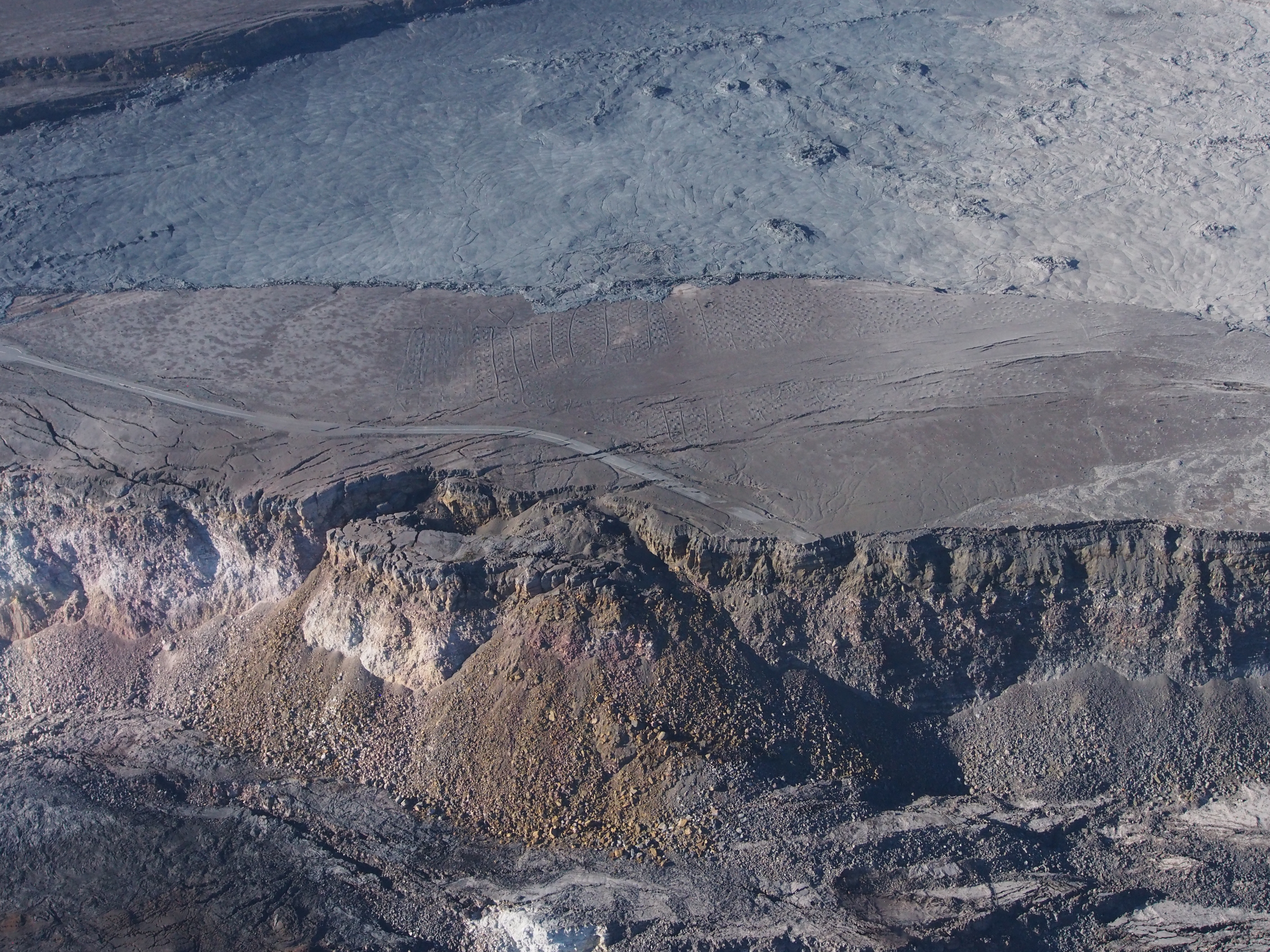
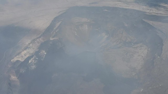
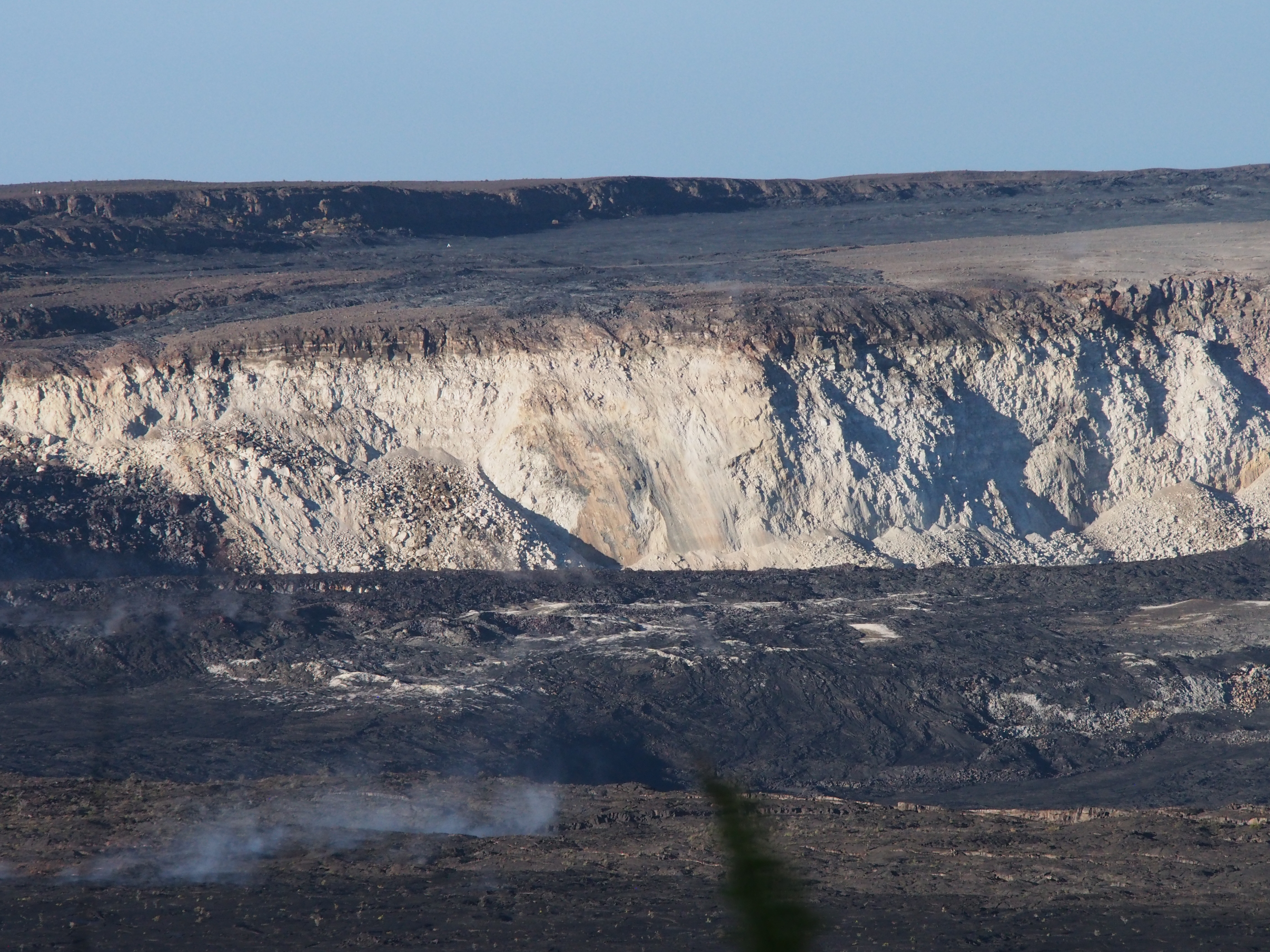
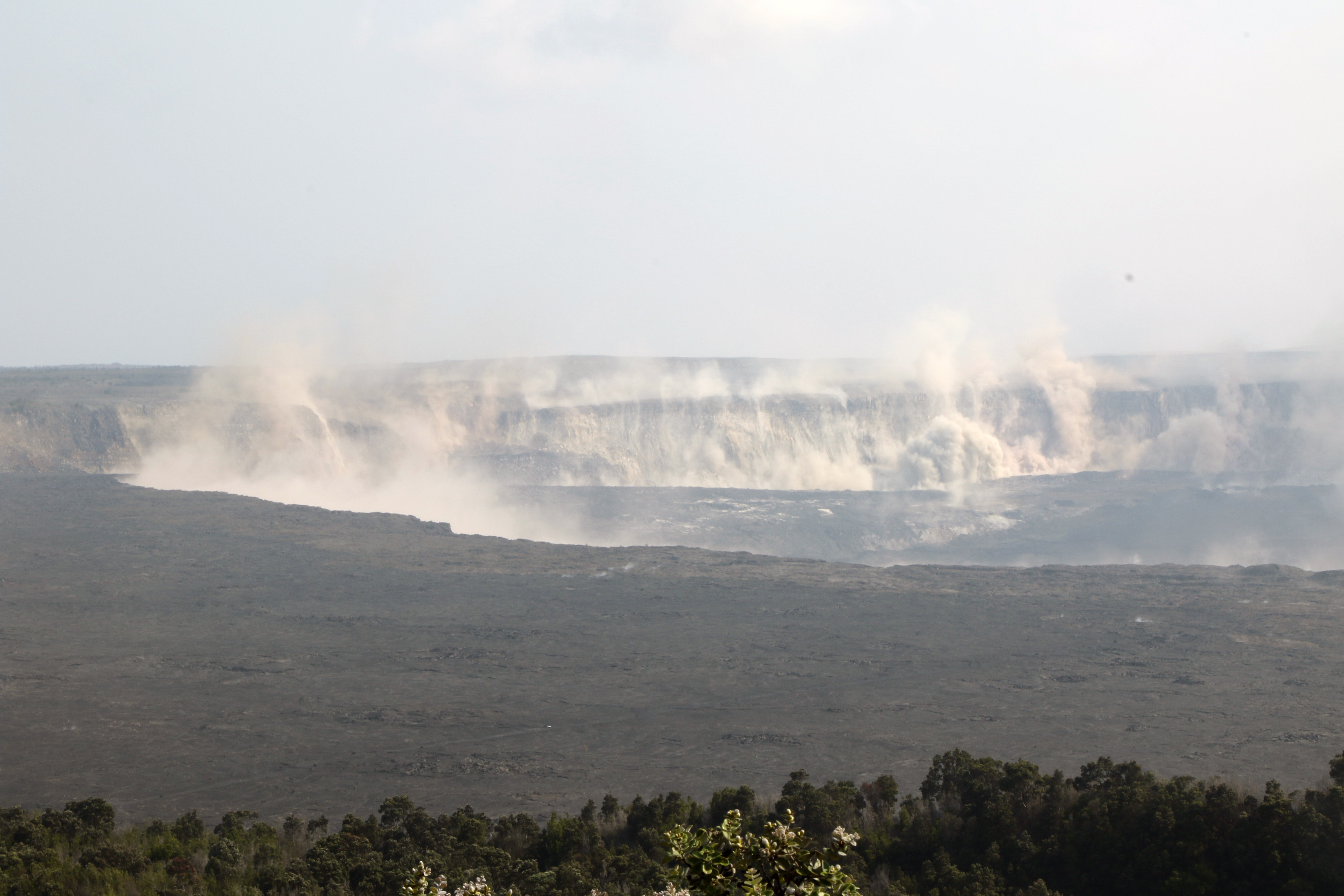
August 6, 2018. USGS: “Kīlauea’s summit remains quiet following the most recent collapse event on August 2 at 11:55 a.m. HST. This quiet is a significant departure from the pattern of episodic seismicity and continuous deformation over the past several months, with very low rates of seismicity continuing today. Deformation at the summit as measured by tiltmeter and GPS instruments slowed and virtually stopped between August 4 and 5. This view of Halema‘uma‘u is toward the southeast.” (Full-sized)
Today’s Eruption Summary
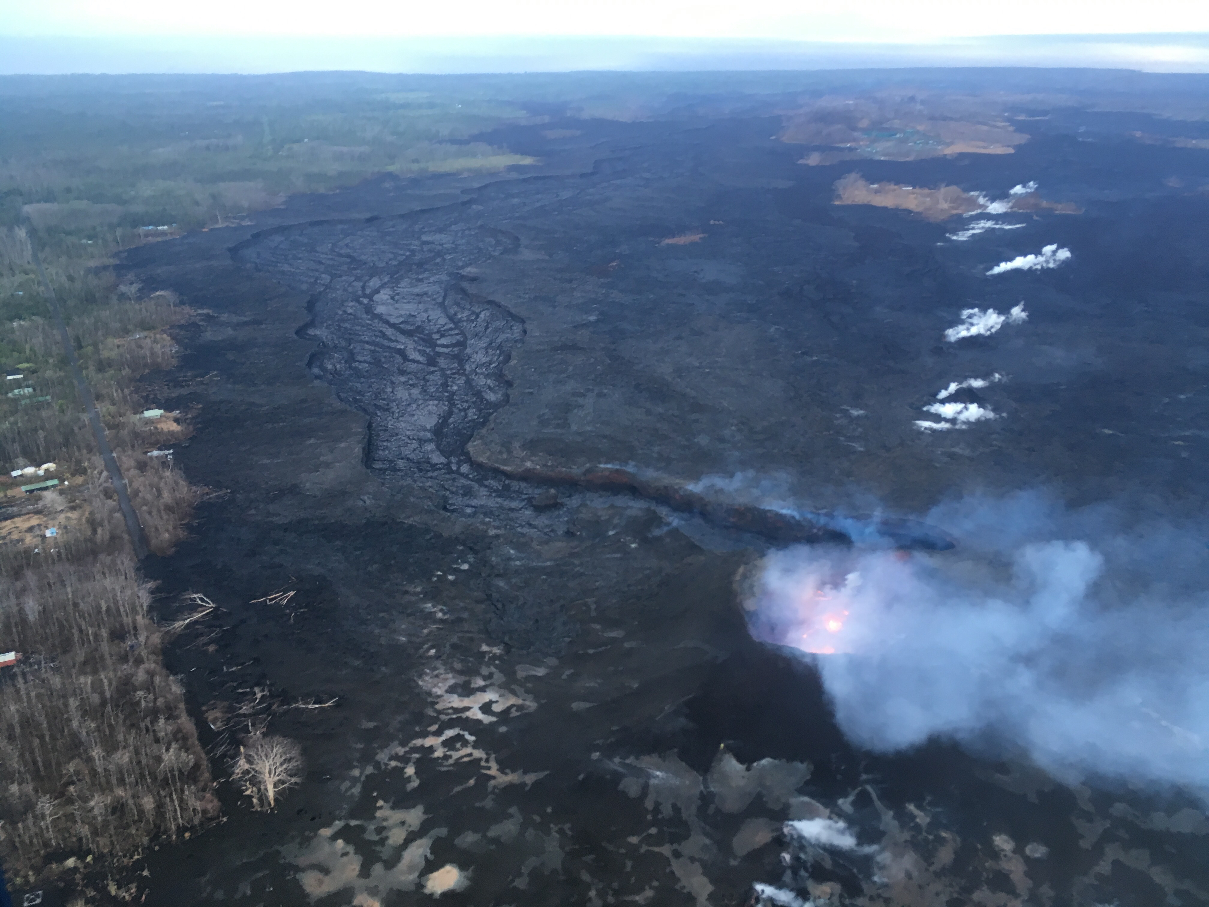
Little lava is leaving Fissure 8 today. It’s still bubbling away within the cone, but the channel below it is crusted over, with only residual lava draining down towards Ahalanui and the edge of Isaac Hale Park, and almost no laze plume. The summit’s seismicity is way down, and there’s almost no inflation or deflation since August 3. Now the question becomes: is this a temporary pause, or is this eruption really over?
August 6, 2018. USGS: ” This morning’s overflight revealed a weak to moderately active pond of lava bubbling within the fissure 8 cone, but no visible supply of lava from fissure 8 into the channel. The perched channel and braided sections downstream were essentially crusted over with some incandescence noted. Active flow in the channel was observed immediately west Kapoho Crater.” (Full-sized)August 6, 2018. USGS: “There were small active lava ooze outs at the coast in the vicinity of the former Kapoho Bay and Ahalanui, and the laze plume was greatly diminished. Active lava is close to the Pohoiki boat ramp but did not advanced significantly toward it over the weekend.” (Full-sized)August 6, 2018. USGS: “High-elevation view of Halema‘uma‘u and the larger Kīlauea Crater from this morning’s overflight, with Mauna Loa in the background. HVO and NPS Jaggar Museum are located on bluffs at the far side of the crater in the center of the view. Note the smoke plume from a still-burning brushfire on the lower flank of Mauna Loa.” (Full-sized)August 6, 2018. USGS: “This photo shows a portion of the Crater Rim Drive that led from the east to the Halema‘uma‘u parking area, which slid into the growing crater weeks ago. Note a slump block located below and near where the road ends at Halema‘uma‘u. The September 1982 lava flow can be seen in the top of the photograph.” (Full-sized)
By the way, while trying to track down photos of the September 1982 lava flow, I found an old webpage (No datestamp, but Internet Archive first scraped it in 1999) with some interesting aerial photos of Kīlauea Caldera from the 70s and 80s. It would be fun to try to match the 1974 aerial photo with a new one, but I haven’t seen one taken from that high yet.
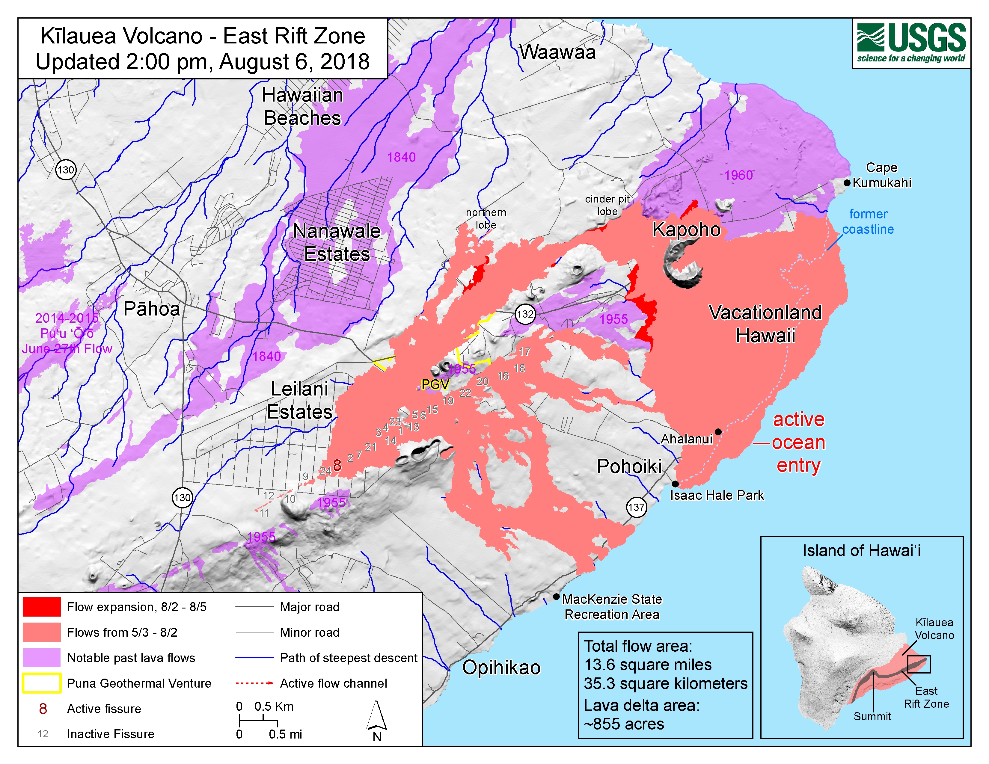
August 6, 2018, 2 pm HST. Latest USGS map of Lower East Rift Zone. (Full-sized)
At the top of this post, I posted Mick Kalber’s overflight video from this morning. Bruce Omori posted his photos and notes from this flight on the Lava Update blog, same post mirrored on Facebook with a few more observations:
Lava Update for Monday, Aug 6, 2018, 6:00 am – Kilauea's lower east rift zone overflight:Kīlauea's eruptive activity…
Eruption continues as usual with three minor things to note. First: “fuming” on the southwestern margin of the flow near Pohoiki could mean possible breakouts, according to today’s HVO Kilauea status update.
Same source also says that, rather unusually, a 4.1 earthquake at 10:02 pm was felt all the way to Hilo, far more widely than the stronger summit collapse events, possibly because it was at a depth of 7 miles.
And finally, Tuesday will mark the 89th day of the eruption, surpassing the length of the 1955 Kapoho eruption which had previously held the record for the longest LERZ eruption since westerners arrived and began keeping records.
I tweeted him a question about “Halema’uma’u Caldera,” which he seems to be using instead of “Kīlauea caldera.” I know Halemaʻumaʻu crater has expanded so much it could be classified as a caldera now, but so far HVO scientists have resisted doing so, to avoid confusion with the larger, older caldera.
July 30 HCFD Overflight Photos
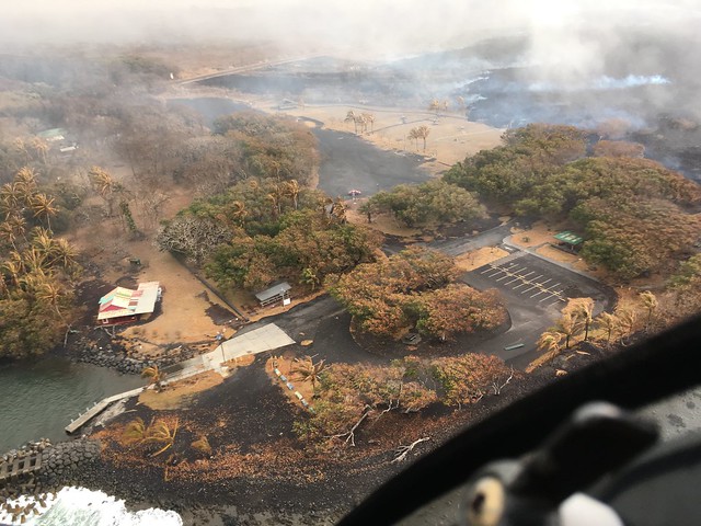
HCFD’s July 30 album is up on Flickr. Just 12 photos plus the video clip at the top of this post. Including the clearest views we’ve seen of Isaac Hale Park in some time, since the laze plume wasn’t in the way:
Here’s a few USGS photos from today plus the LERZ map, and overflight video and photos from Mick and Bruce:
Even though I finished my July 26 post last night at 1 am my time, HVO posted a few more photos after that. They show Fissure 8 pulsing, varying in lava output, not just due to summit collapses but simply as natural fluctuations.
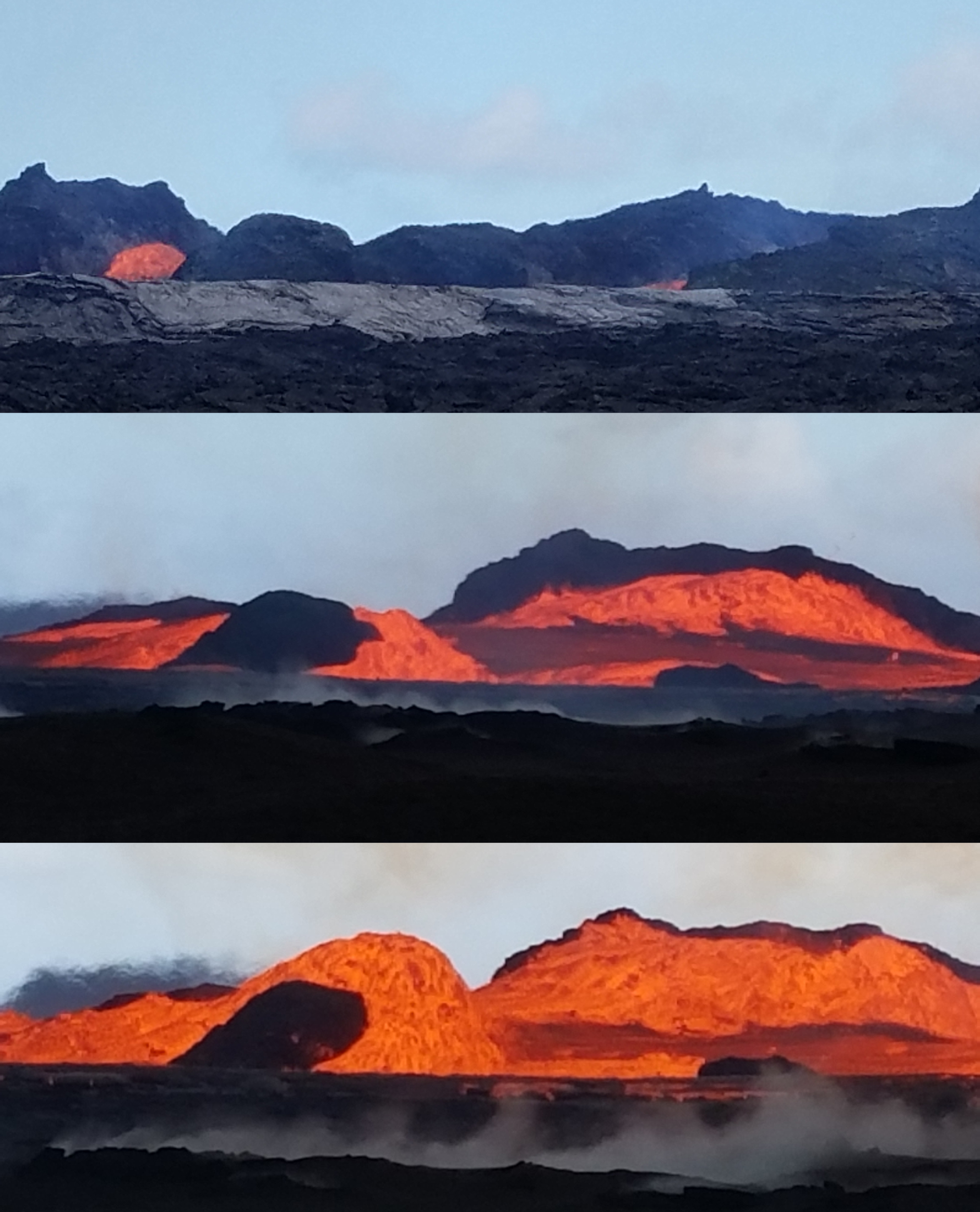
July 26, 2018. Fissure 8 lava pulses. (Full-sized)
Caption: Pulses of lava from the fissure 8 vent sometimes occur every few minutes. These photographs, taken over a period of about 4 minutes, show the changes that occur during these pulses. Initially, lava within the channel is almost out of sight. A pulse in the system then creates a banked lava flow that throws spatter (fragments of molten lava) onto the channel margin. After the third photo was taken, the lava level again decreased to nearly out of sight.
(I often compare volcanic activity to weather— it’s essentially geological weather, with currents and flow and updrafts from deep within the Earth, only the medium is solid and molten rock rather than air and water. When people are asking for volcanic forecasts, they’re asking for weather forecasts, and should expect the same kinds of variability as rainstorms.)
And here’s a night view they posted in the wee hours of this morning (Jul 27):
July 26, 2018. USGS: “Nighttime view of fissure 8 lava as it exits the vent and feeds into the channel.” (Full-sized)
And while I’m at it, here’s the photos for the afternoon of July 27. HVO might post more later tonight.
USGS/HVO Deputy Scientist-in-Charge Steve Brantley has been giving weekly 10-minute slideshows at Tuesday evening Pahoa Community Meetings. Here’s last Tuesday’s.
Transcript:
Good evening. Thank you for coming out tonight. I have just a short presentation to provide for you this evening, and I invite you to come back to the back of the room at the end of the meeting. I have copies of the report that we put out on Thursday of last week, so you’re welcome to take a copy. Please, one per household. And I’ll draw attention to— the centerpiece of that report is a map. And I have a copy of the map back there that we can talk about if you’d like.
So the activity this past week has not changed significantly, either at Fissure 8 or along the lava channel or at the summit. The summit keeps dropping during these episodic earthquakes, where parts of the crater floor drop 2-2 ½ meters, 7-8 feet at a time, and also overall slow subsidence.
Three months ago today, shortly before 5 pm on May 3, lava began to erupt from one of several cracks that had opened in Leilani Estates in the Lower Puna district of the Big Island of Hawai’i. This followed several days of earthquakes indicating magma moving downrift from Puʻu ʻŌʻō, after its floor collapsed and its lava drained away overnight on April 30.
At first, the fissures spattered and sputtered, with most of the lava falling on both sides of the vents and building up ramparts (walls). Individual fissures erupted for several hours at a time, then died out. Some restarted, others simply steamed. A few sent out sluggish lava flows, claiming a few houses.
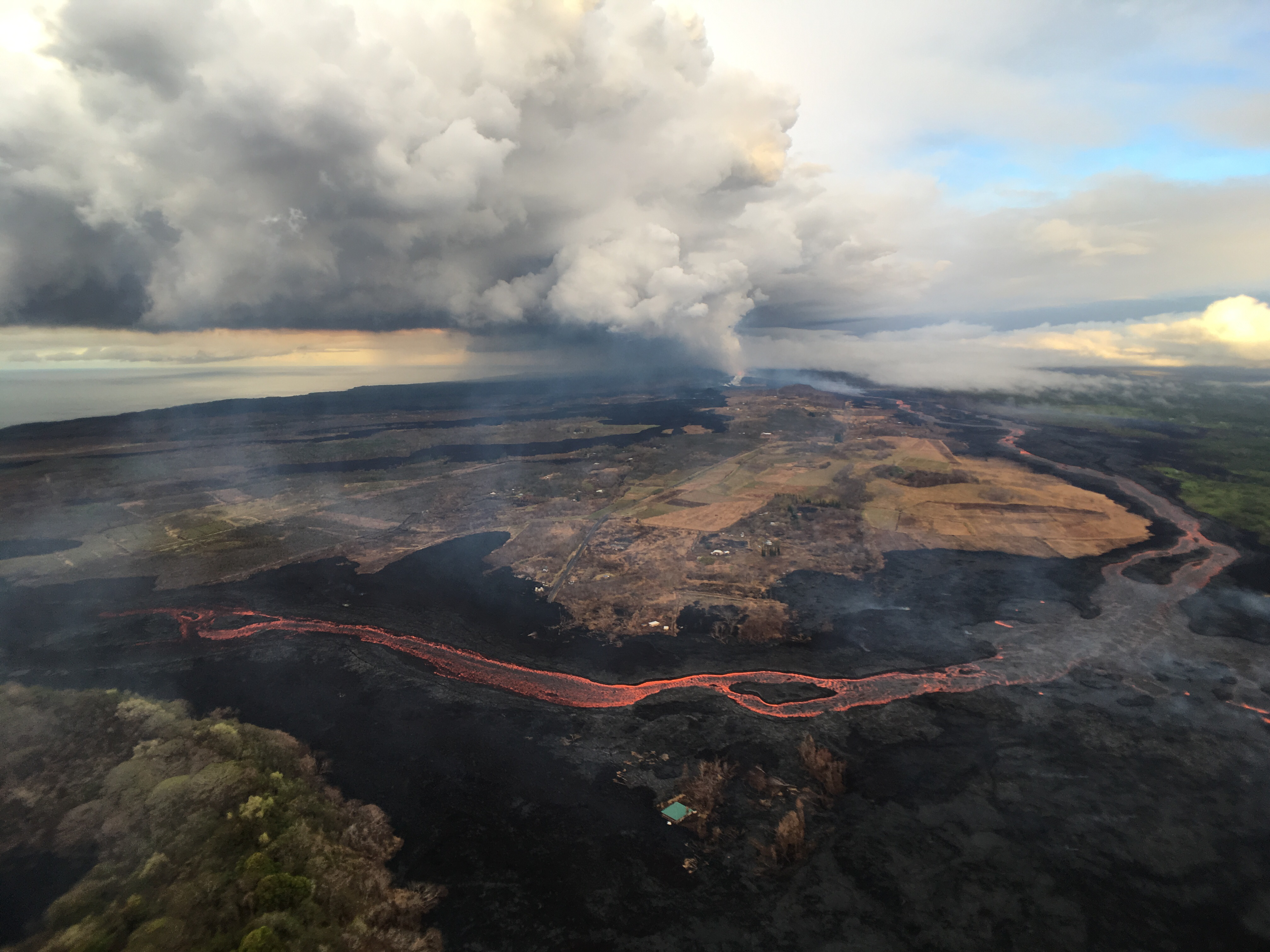
On May 19, the eruption began in earnest. Most of the old, stale lava stored in the rift zone since the 1955 and 1960 eruptions had been pushed out, and fresh, hot, runny lava from Puʻu ʻŌʻō began pouring out of vents, sending the first lava flows down to the sea (See the Honolulu CivilBeat livestream from that day, timestamp 6:03). Lava reached the ocean before dawn on May 20.
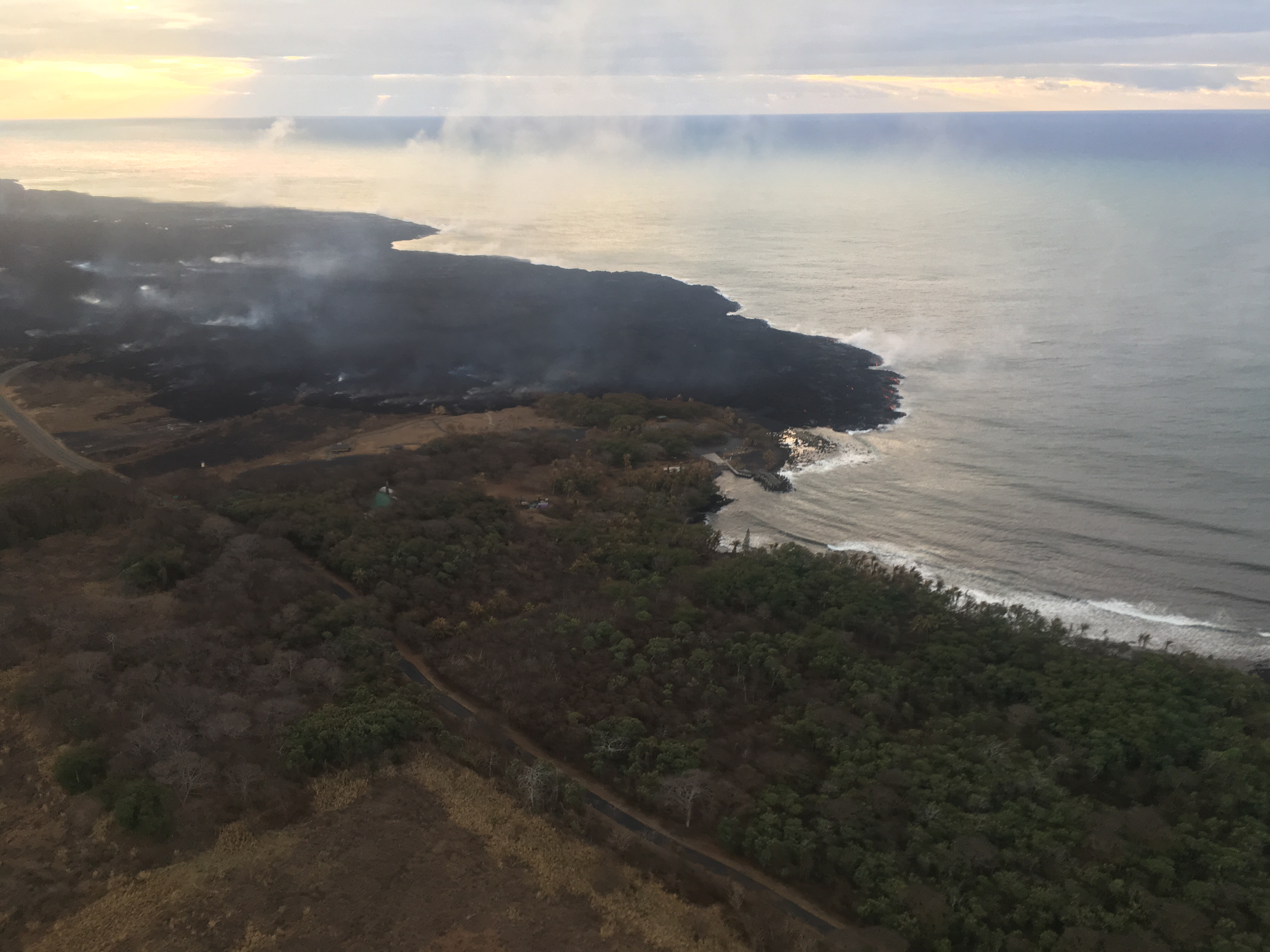
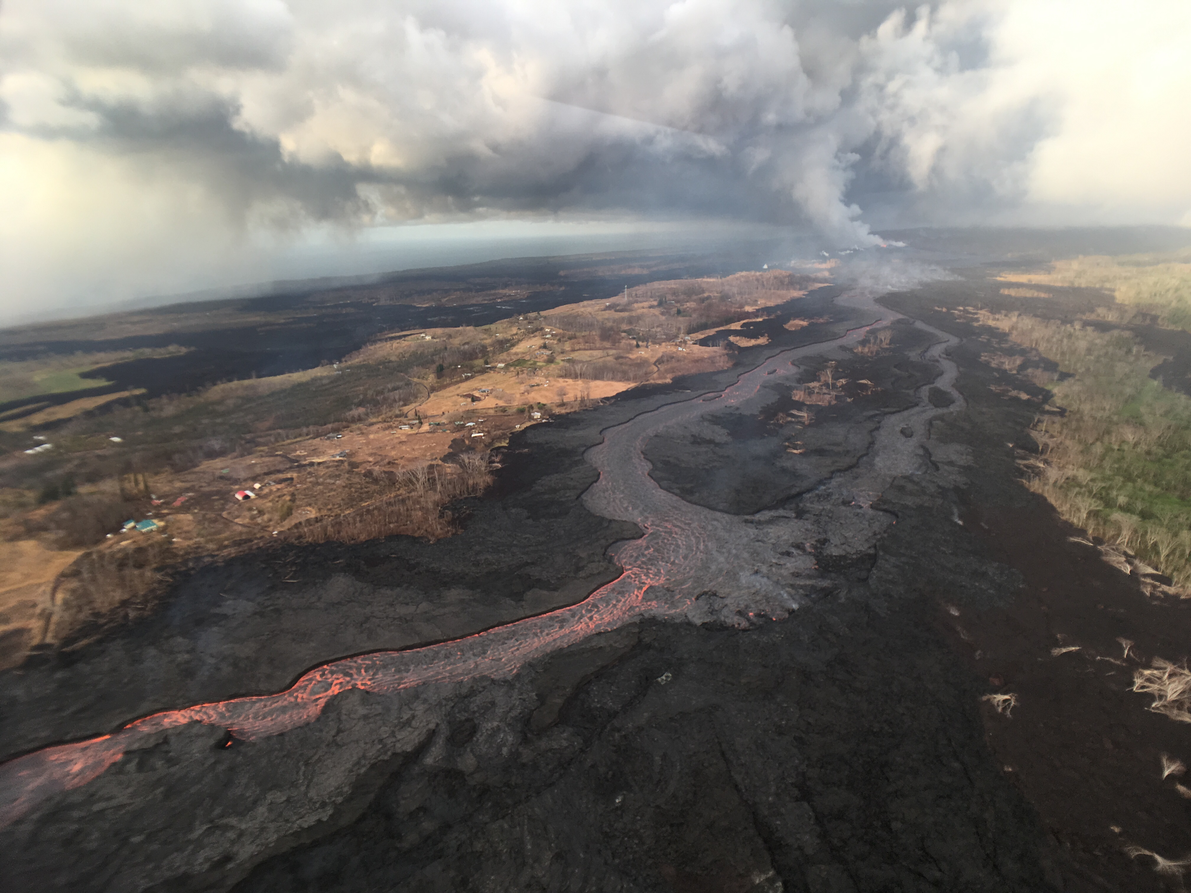
While Fissure 8 had originally opened on May 5, it was just one of many attempts for all that magma coming down the rift zone to find the most convenient exit. (Magma can reshape its own plumbing, just as we’ve seen lava do on the surface.) Fissure 8 reactivated again on May 28, and within a few days became the dominant vent for this eruption. Its lava flow reached Kapoho Bay the evening of June 3, and had covered the bay within 36 hours.
All that magma exiting the summit caused the lava lake at the summit to drain away, then Halemaʻumaʻu fell into it and started enlarging, and eventually much of the floor of Kīlauea caldera began to subside as well. The collapses were explosive at first, then, after the lava lake’s conduit had been thoroughly blocked by rubble, the collapses settled into a regular pattern.
So here we are. The LERZ eruption has added nearly 800 acres to the island, covering lower Puna with 34.0 square kilometers (13.1 square miles) of lava. We’ve almost come to take for granted this extraordinary eruption, which has dramatically reshaped the summit of Kīlauea and produced more lava in 3 months than Puʻu ʻŌʻō did in 35 years.
Today’s Eruption Summary
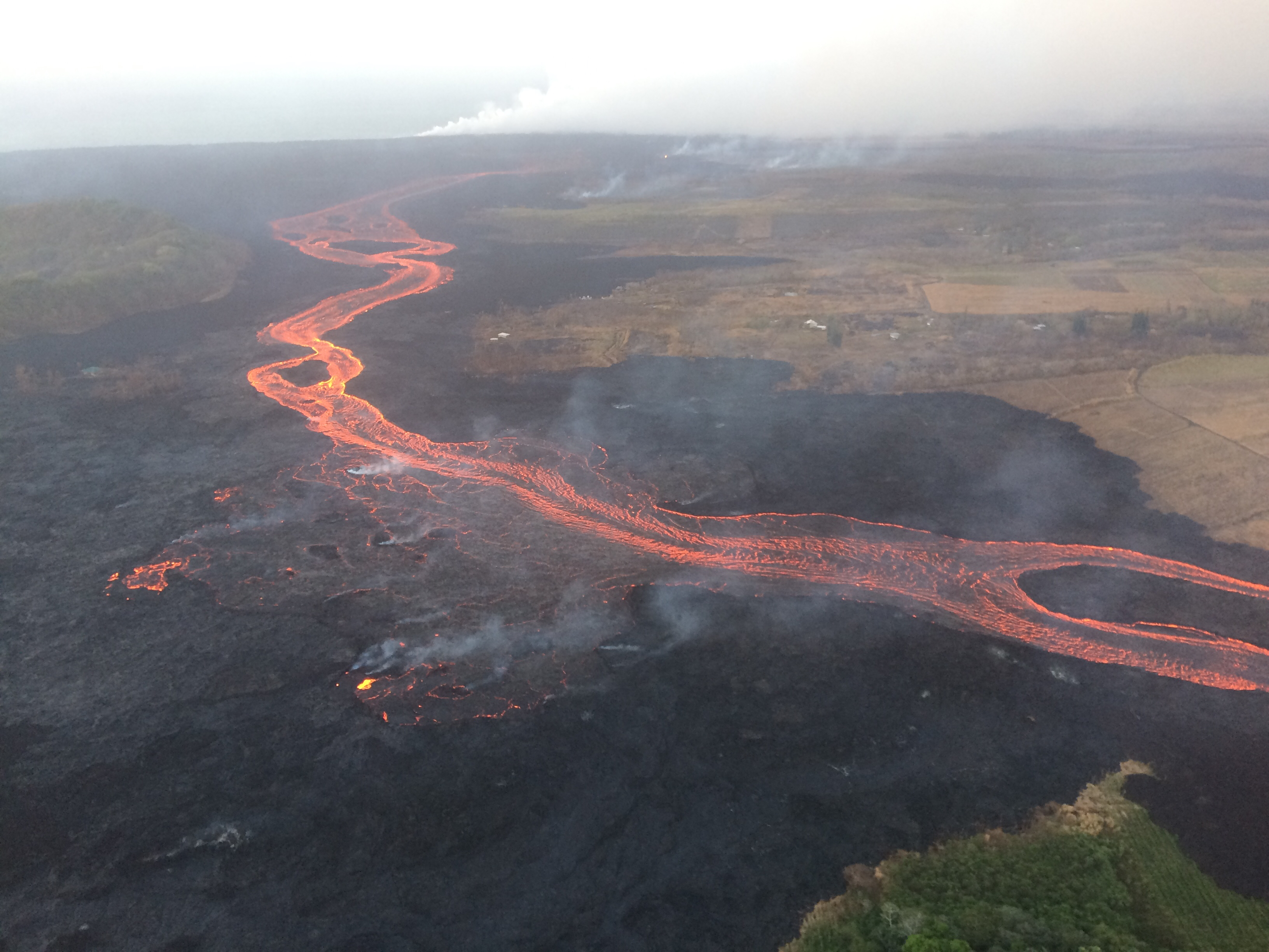
July 26, 2018. USGS: “Fissure 8 continues to erupt lava into the channel leading northeastward from the vent. This north-facing view of the cone, vent, and proximal channel was taken during HVO’s overflight this morning.” (Full-sized)
HVO’s volcanologists have told us that eruptions like this wax and wane— Puʻu ʻŌʻō certainly did, sometimes pausing for weeks— and that part of what makes Fissure 8 extraordinary is that it’s sustained such a high volume of lava effusion for so long. Today, it’s finally showed signs of weakening— maybe? The USGS reported that its lava flow seemed sluggish and that lava levels are down in the lower part of the channel. The flow margin remains stalled a mere tenth of a mile from Pohoiki’s boat ramp.
July 26, 2018. USGS: “At the coast, the lava flow in the Ahalanui area remains less than 0.1 miles from the Pohoiki boat ramp at Isaac Hale Park (left of center in this photo). The active ocean entry is a few hundred yards east (right) of this photograph.” (Full-sized)
USGS: “As of 2:00 p.m. HST, July 26, 2018, the lava flow margins had not expanded since the previous map, so no red areas (indicating expansion) appear on this map.” (Full-sized)
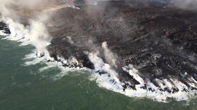
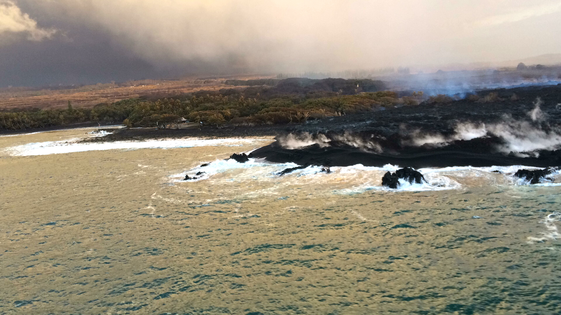
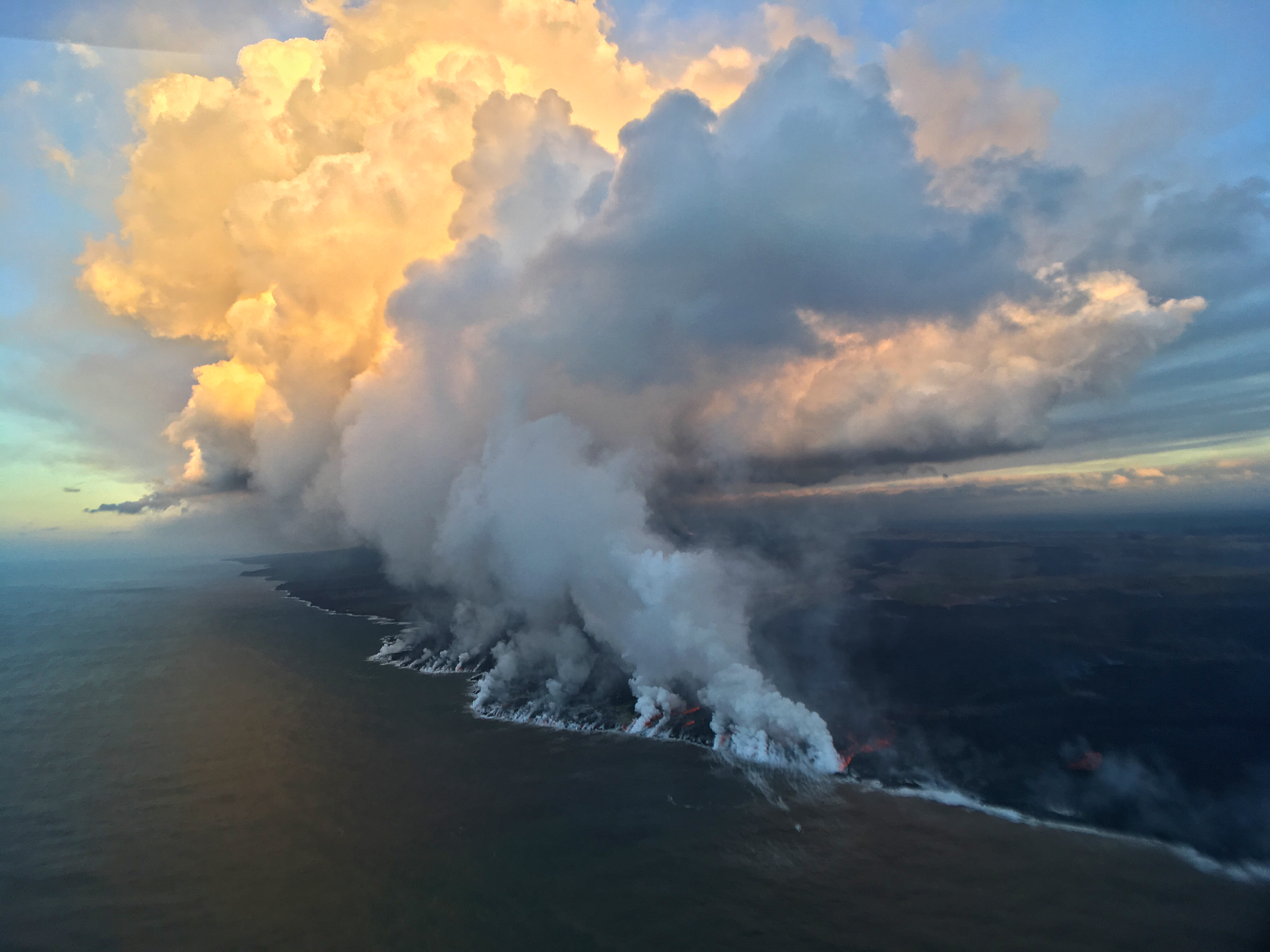
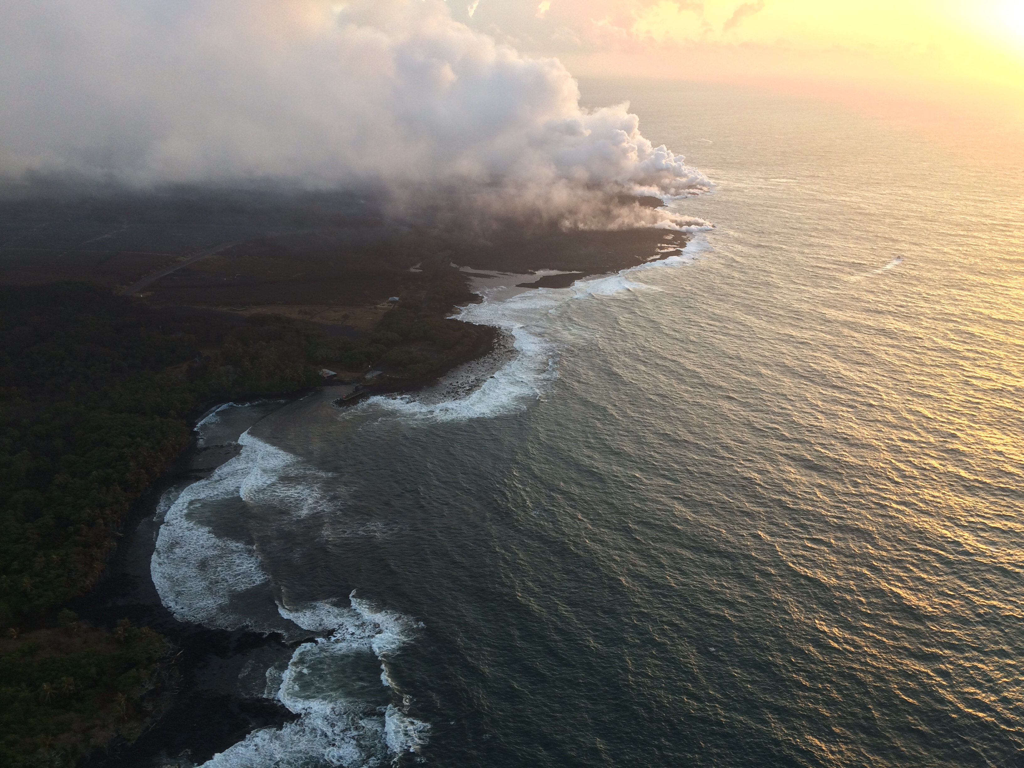
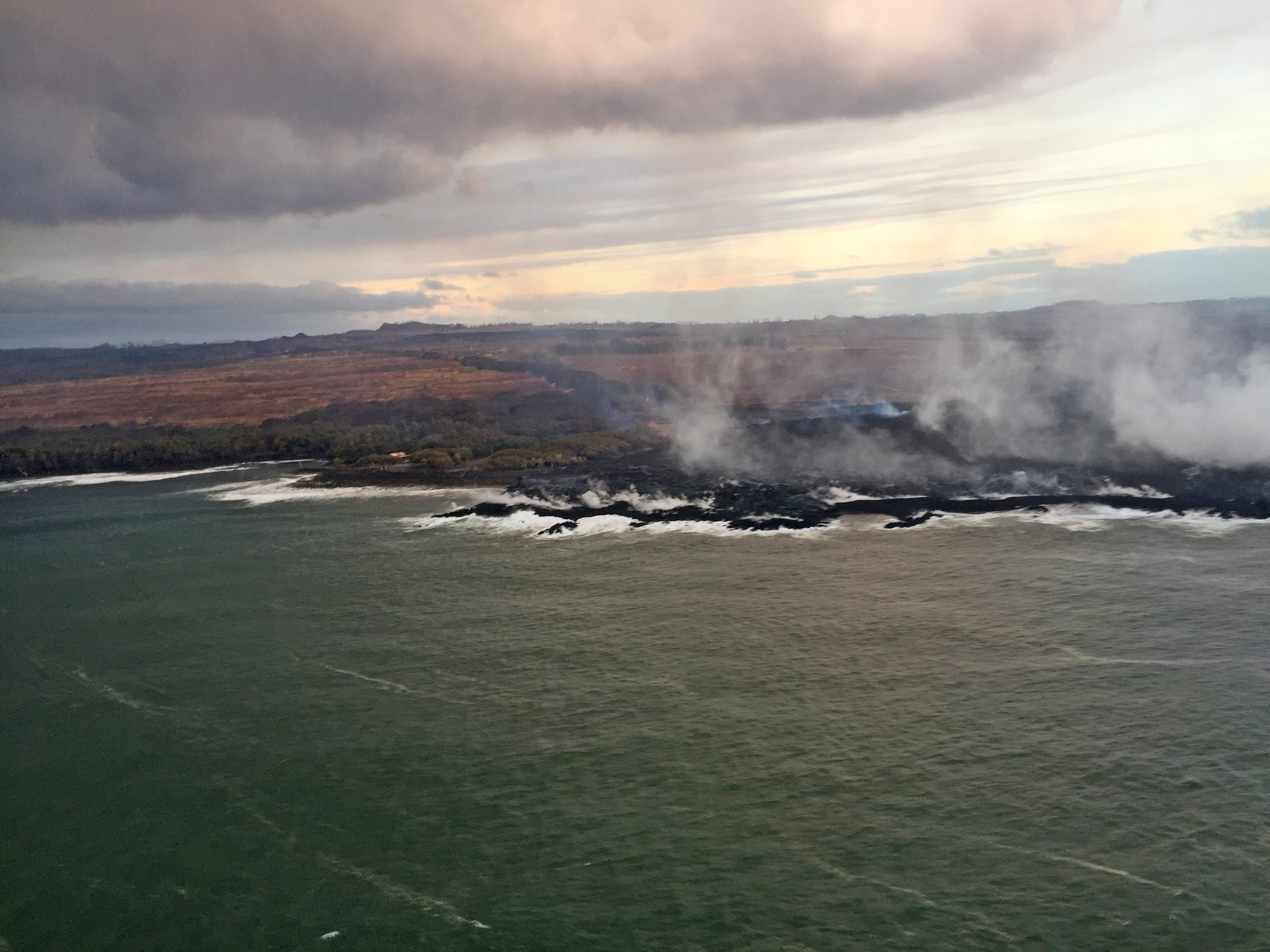
July 25, 2018. USGS: “Early this morning, several small lobes of lava were oozing out from crusted ‘a‘ā flows along the southern ocean entry.” (Full-sized)
Today’s Eruption Summary
As we approach the 3-month mark— or pass it, since Puʻu ʻŌʻō’s floor collapsed 3 months ago this past Monday— Kīlauea’s 2018 eruption continues with no significant changes. During the USGS morning overflight, the lava’s southwestern margin was holding at less than a tenth of a mile from Pohoiki boat ramp. The vigorous ocean entry continues a few hundred yards to the east. No surges in lava output have been reported at Fissure 8 since Tuesday’s 6:41 am summit collapse.
July 25, 2018. USGS: ” HVO’s overflight early this morning revealed little advancement of the westernmost ocean entry. During the overflight, lava was approximately 145 m (475 ft) from the boat ramp at Isaac Hale Park (near the light-colored structure just left of center in this photo).” (Full-sized)
A deceptive moment of tranquility at the new, extensively remodeled summit:
July 25, 2018. USGS: “Earthquakes shook the ground at Kīlauea’s summit late this afternoon, stirring up rock dust within Halema‘uma‘u and along the caldera walls. This view from the northeast caldera rim looks across at the Keanakāko‘i and South Sulphur Banks areas.” (Full-sized)
Here’s HVO’s Steve Brantley giving the weekly eruption update at last night’s Pahoa community meeting (I’ll be transcribing it tomorrow or Friday).
He explains that complicated “lavashed” map released earlier this week, which predicts where lava is most likely to go if there’s a breakout along particular stretches of Fissure 8’s lava channel. This is an aid to residents living in neighboring areas not affected by lava now, but who are worried about what might happen if the flow diverts.
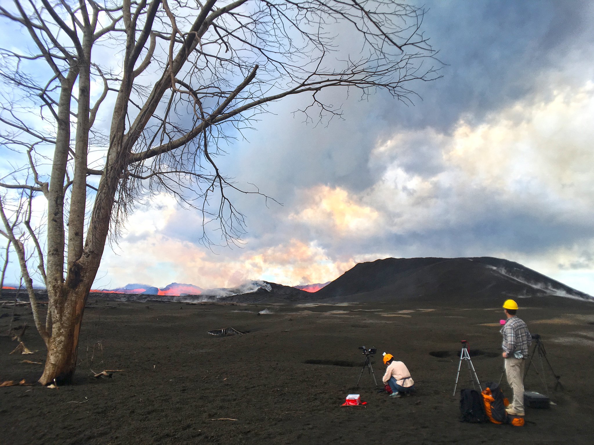
July 24, 2018: Two HVO geologists out standing in their field. USGS tweeted this among a batch of photos today. (Full-sized)
Today’s Eruption Summary
Today’s summit collapse event at 6:41 am was upgraded to 5.6 a 5.3, as usual. The USGS apologized for calculations errors for the past 3 days
Since I was out and missed it on livestream, I’m very glad HVO captured it. Here’s yet another trick from Pele’s repertoire:
There’s a lot to look at here. From USGS caption:
“In this video, watch as today’s event unfolds from the perspective of HVO’s live-stream camera. At 6:41:08 (time stamp at upper left), a small tree along the right margin of the video begins to sway. At 6:41:10, a pressure wave passes through the steam plume in the crater, and light is reflected back to the camera (highlights the passage of the expanding sound energy through the air.) At 6:41:11, a rockfall begins on the South Sulphur Banks, a distant light-colored scarp on the left.”
Field crews reported no surge at Fissure 8 following today’s summit collapse.
I notice the latest HVO Kilauea report says Fissure 8’s cone is down to 50 m, “or 55 yards.” It’s definitely crumbled or eroded— that may be responsible for some of the lava boats— but I’m never sure whether they’re measuring from the original ground level or the lava on which it sits. At any rate, the fountaining is lower, too, since it’s not rising above the lip of the cone.
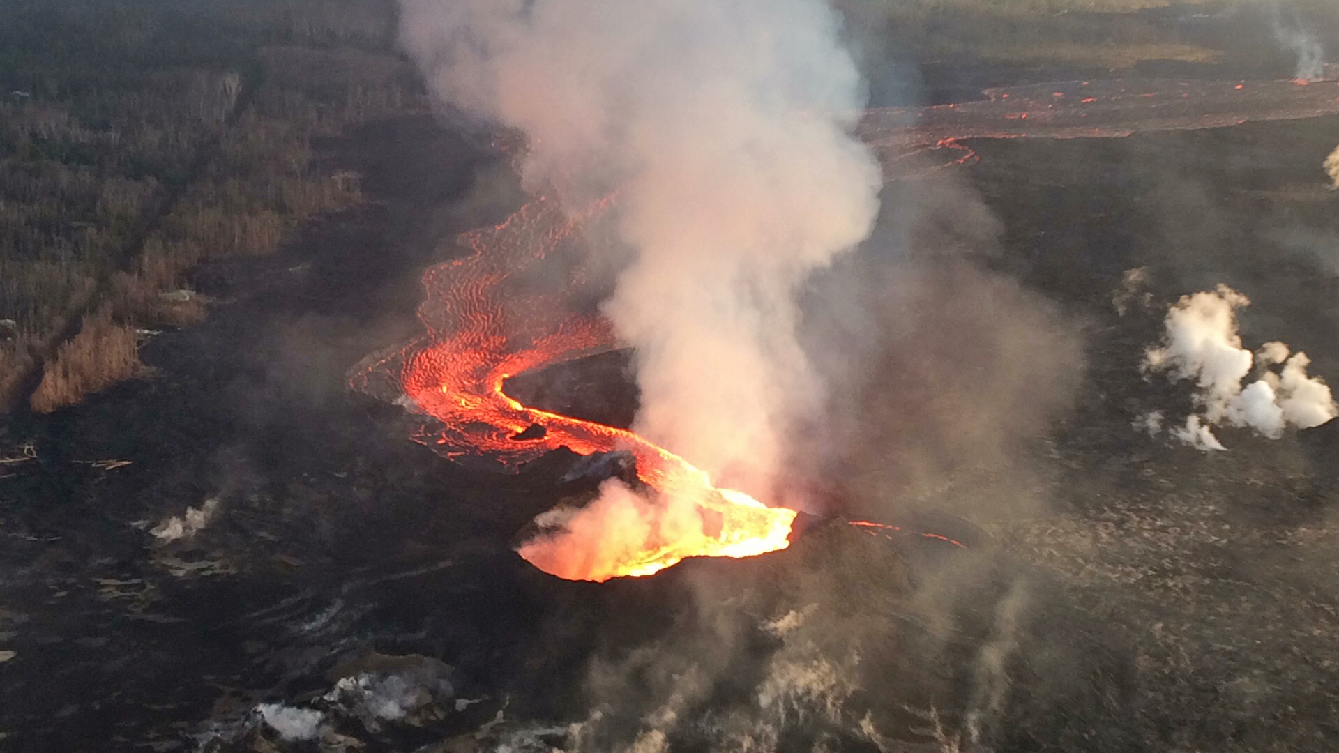
July 24, 2018. USGS: “Fissure 8 lava channel as viewed from HVO’s morning overflight today. The robust volcanic gas plume in the far distance was rising from the fissure 8 vent.” (Full-sized)
Down at the ocean entry, the main channel is still dumping into the sea from multiple toes near former Ahalanui.
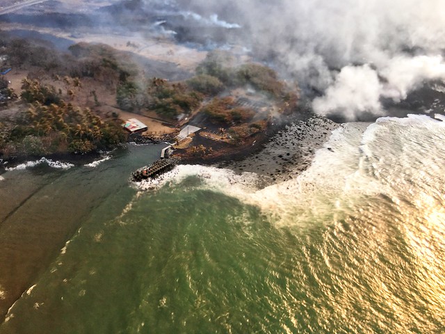
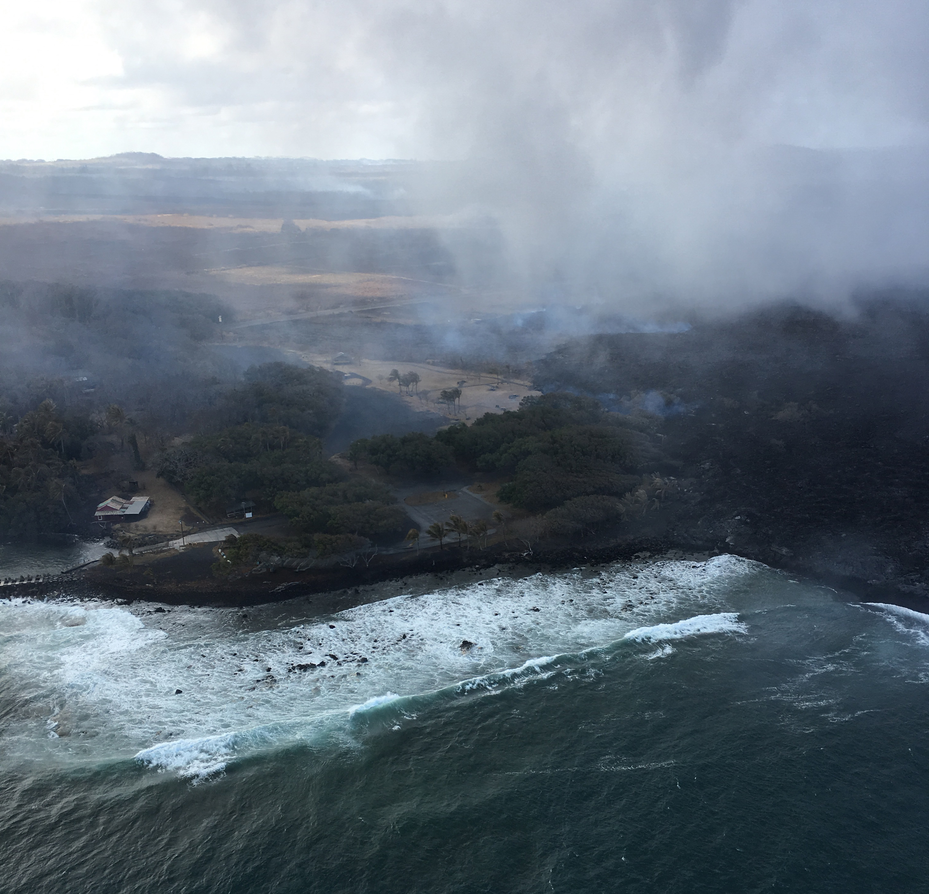
July 24, 2018. USGS: “The Hawaii County Fire Department captured this image of Isaac Hale Park and boat ramp during their overflight of the area late this afternoon.” (Full-sized)
I’m impressed HCFD was able to catch a glimpse under the thick, low laze plume, which was obstructing the view during @HotSeatHawaii’s overflight, which looked about like this (in fact the USGS helicopter was down below them):
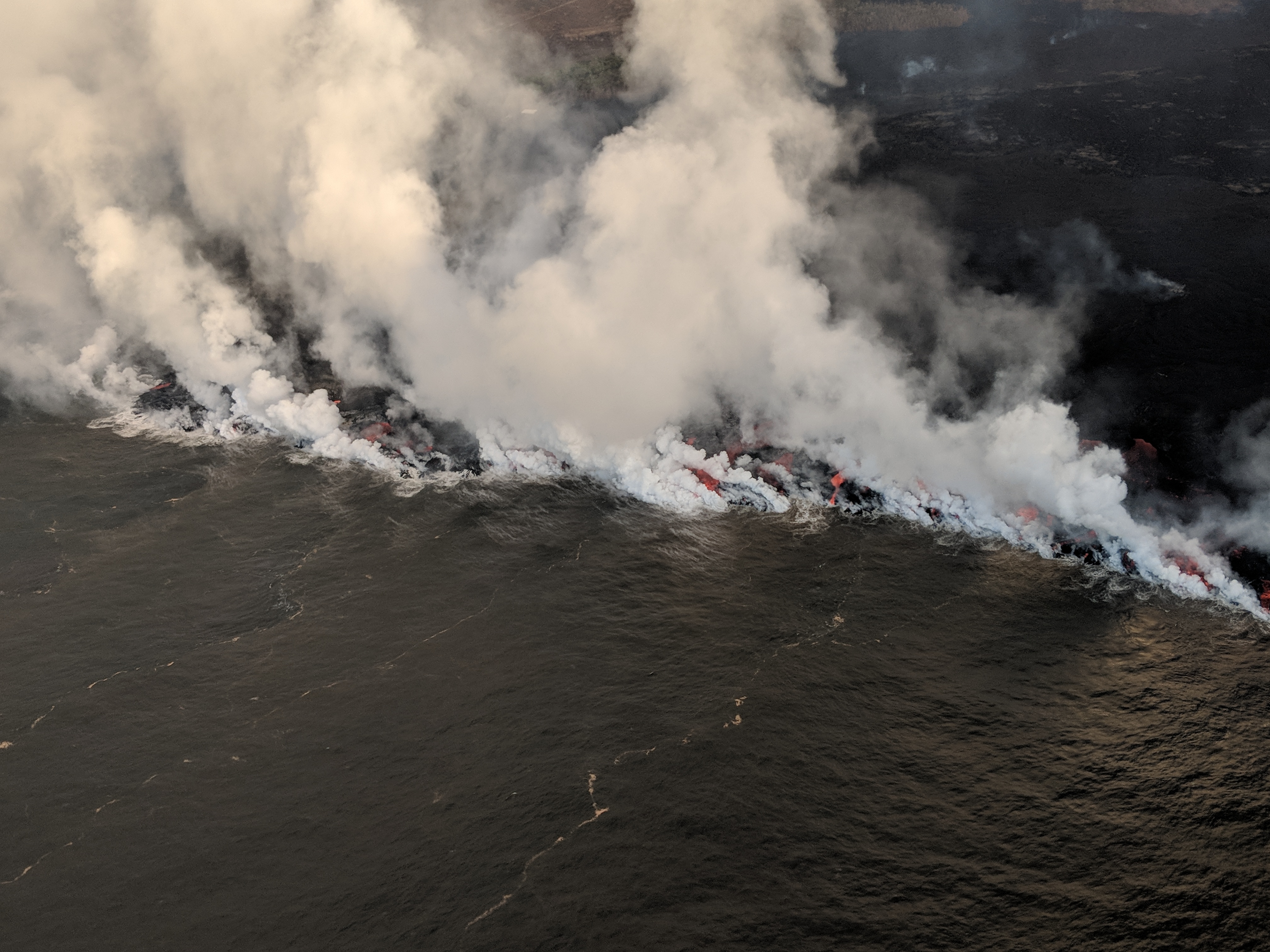
July 24, 2018. USGS: “The ocean entry has expanded to the southwest through a series of lava ‘ooze-outs’ from the southern flow margin that organized into an incipient channel. As of this morning, the flow margin was in or at the edge of Isaac Hale Park, approximately 175 m (575 ft) from the Pohoiki boat ramp. Unfortunately, the view was obscured by laze (the smaller plume below the larger laze plume) during the overflight.” (Full-sized)
“Ooze-outs” are occurring along the west side of the active flow south Kapoho Crater, all the way down to the ocean (where it is threatening Isaac Hale).
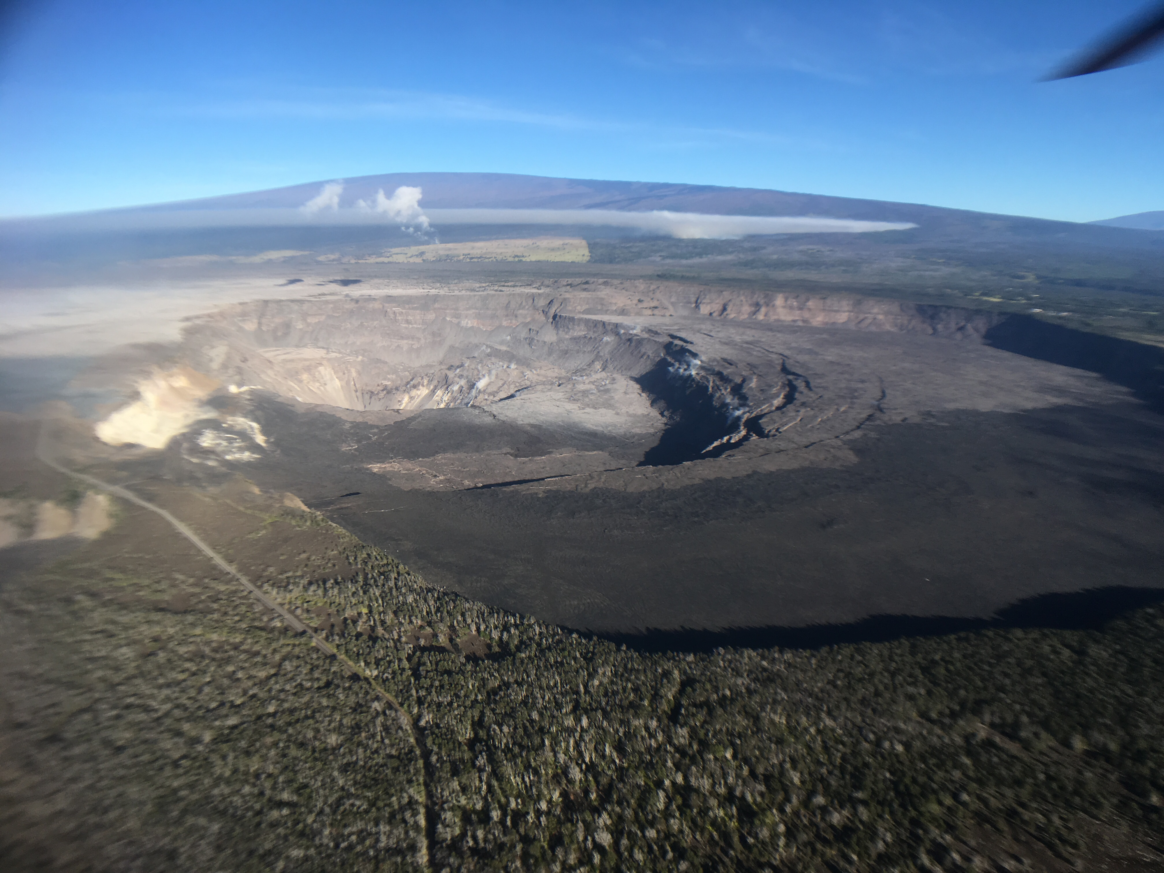
Other news that slipped under the radar: HCFD took a swing by the summit yesterday! It was very dusty and hazy, but the new shape of Halemaʻumaʻu is becoming clear:
Look for Crater Rim Drive at lower left around 0:30, falling into the crater where it used to lead to the parking lot; HVO is really hard to glimpse at upper right.
There were several more photos, giving us a little more perspective on the whole of Kīlauea Caldera as it is now:
July 23, 2018. View of lava channel from F8 where it bends to south and heads for ocean (laze plume in background). USGS: “The fissure 8 channel continues to carry lava toward the coast on the west side of Kapoho Crater (vegetated cone, far left). Northwest of this cone, overflows (lower left) of the channel occurred overnight, but lava was confined to the existing flow field and did not threaten any homes or structures.” (Full-sized)
Today’s Eruption Summary
The USGS has updated the energy release for yesterday evening’s summit collapse to M5.5. (For more info: “Why Do Earthquake Magnitudes Sometimes Change?” from a 2016 issue of Volcano Watch by HVO.)
Fissure 8 exhibited surge behavior afterwards. Overnight, drone crews observed minor overflows just northwest of Kapoho Cone, most of which were confined to the existing flow field and/or stopped before traveling far enough to threaten structures.
July 23, 2018. USGS: “Lava continued to enter the sea near Ahalanui during HVO’s early morning helicopter overflight of Kīlauea’s lower East Rift Zone (view to northeast). The southern margin of the flow was still about [a quarter mile] from the boat ramp at Isaac Hale Park this morning. The jetty along the launch ramp is visible near the center of the photo.” (Full-sized)The main ocean entry and southern margin of the flow haven’t moved much in the past few days. However, USGS reports “a new lobe has started from the southern lobe and is active along its southwestern margin, slowly heading towards the ocean.” Today’s 1 pm map clarifies the new lobe’s location:
July 23, 2018, 1 pm USGS map of LERZ lava flow field. Note small overflow by Fissure 8 as well as upstream of Kapoho bend on the north side of the braided channels. (Full-sized)
Ikaika Marzo, a lava tour boat operator who stays a sensible distance from shore, reportedly saw lava is in Isaac Hale Park, within 50 m of Pohoiki boat ramp at 7:15 this evening.
No summit collapse today, unless the pattern changes; the next one ought to occur tomorrow morning.
Here’s highlights of the USGS Media Conference Call from this afternoon:
July 22, 2018. Posted by USGS on Facebook: “A telephoto view into the fissure 8 cinder cone, taken during the early morning helicopter overflight.”
Today’s Eruption Summary
Status quo. No significant overflows today from Fissure 8’s lava river. USGS morning overflight put the southern margin of the coastal flow field at 500 m from boat ramp at Isaac Hale Park. In other words, not much movement in that direction.
Summit collapse occurred while I was writing up this post, as expected: 8:54 pm HST, back to an energy equivalent of M5.3 on reviewing readings, they upped this one to 5.5! Let’s see whether that results in an early-morning Fissure 8 surge tomorrow, er, today, Monday.
July 22, 2018. USGS: “The main ocean entry, as observed early this morning, was located a few hundred meters (yards) northeast of the southern flow margin, which remains about 500 m (0.3 mi) from the boat ramp at the Isaac Hale Park.” (Full-sized)
When the National Park opens again, they’re going to have a new— or rather, very old— landmark that I confess I’m rather excited about, although it’s not quite as photogenic as a lava lake. Mark Twain would’ve seen this during his visit in 1866:
July 22, 2018. USGS: “Collapse of Kīlauea’s caldera floor has exposed South Sulphur Bank, prominent in the mid-19th century but covered as lava flows filled the caldera. The flat top of the white deposit shows how high the caldera fill reached. As the caldera floor dropped in mid-June 2018, South Sulphur Bank was again exposed. The height of the bank, now more than 65 m (213 ft), increases about 2.5 m (9 ft) with each collapse event at Kīlauea’s summit. On the caldera floor, white patches lie along spatter ramparts formed in 1971 and 1974.” (Full-sized)
As we approach the 3-month mark, the USGS is beginning to supplement its daily reports on the eruption itself with recognition of scientists and support crew who have been working 24/7 to monitor, collect scientific data and inform civil defense and the public since this eruption began. The drone crew worked overtime last night after being grounded by weather then night before:
July 22, 2018. USGS: “The Unmanned Aircraft Systems (UAS) team frequently works into the night, flying aircraft (also referred to as drones) that hover over the active lava channel to collect data and look for changes, such as significant channel overflows. The moon (bright white area above the UAS team scientist) is partially obscured by clouds.” (Full-sized)
Two maps today, one assembled from yesterday morning’s overflights and one from 2 o’clock this afternoon:
July 21, 2018. USGS: ” Fissure 8, source of the white gas plume in the distance, continues to erupt lava into the channel heading northeastward from the vent. Near Kapoho Crater (lower left), the channel turns south, sending lava toward the coast, where it enters the ocean in the Ahalanui area (shown in next photo). Channel overflows are visible in the lower right.” (Full-sized)
Today’s Eruption Summary
Status quo. Fissure 8’s lava river continues inexorably to the Ahalanui Beach area. At the coast, the flow has nearly stalled in its southern expansion, but according to Civil Defense has crept within ¼ mile of Pohoiki boat ramp.
July 21, 2018. USGS: “This aerial view, looking to the southwest, shows the most vigorous ocean entry of the fissure 8 flow, which is located a few hundred meters (yards) northeast of the southern flow margin.” (Full-sized)North of the main ocean entry, a few small pahoehoe lobes are still dribbling into the sea along the rest of the delta.
Today’s summit collapse event occurred at 9:43 am, registering as M5.4 for a change. It was preceded by widespread rockfalls about 3 minutes earlier, which I included in the video capture (jittery livestream signal notwithstanding):
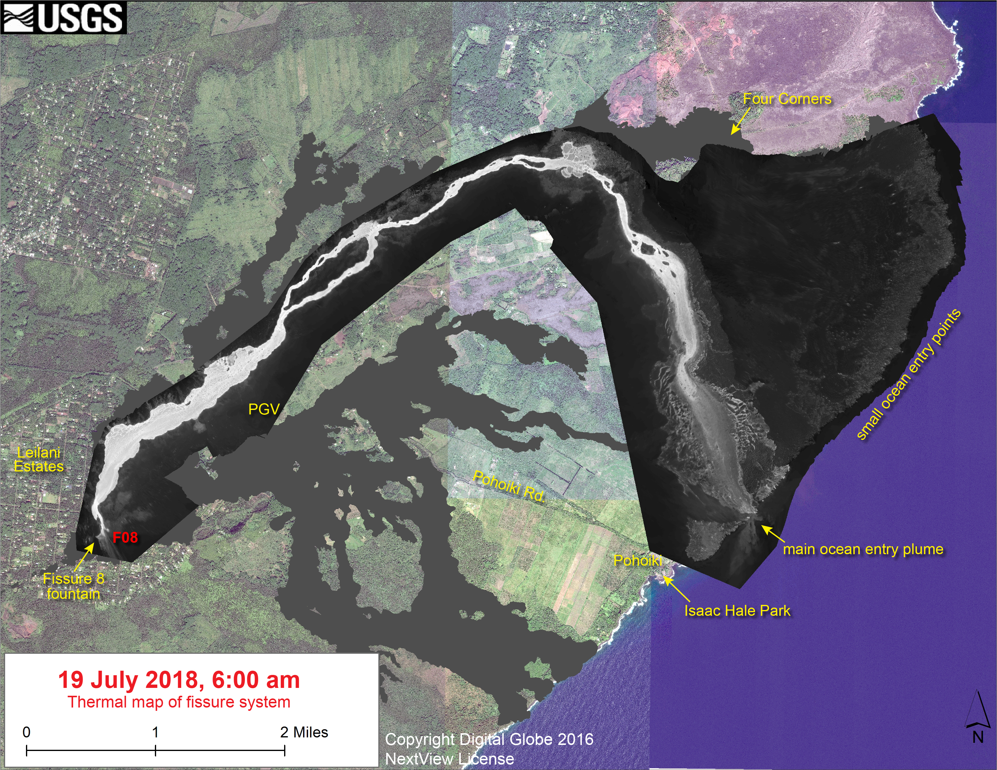
No new LERZ maps today, since the lava’s basically holding position. Here’s the most recent thermal map from July 19 again, since my post had a broken link yesterday.


