July 9: USGS Morning Conference Call

Oh good. Tina Neal herself dropped by today (I think she did some of the early ones, but she’s been understandably busy).

Here’s my transcript of this morning’s 11AM media briefing with USGS, NHS, NPS.

  • Tina Neal, USGS, Scientist-in-Charge of HVO
  • John Bradenburg, NHS
  • Jessica Ferracane, Public Affairs, HVNP
  • Janet Babb, USGS/HVO

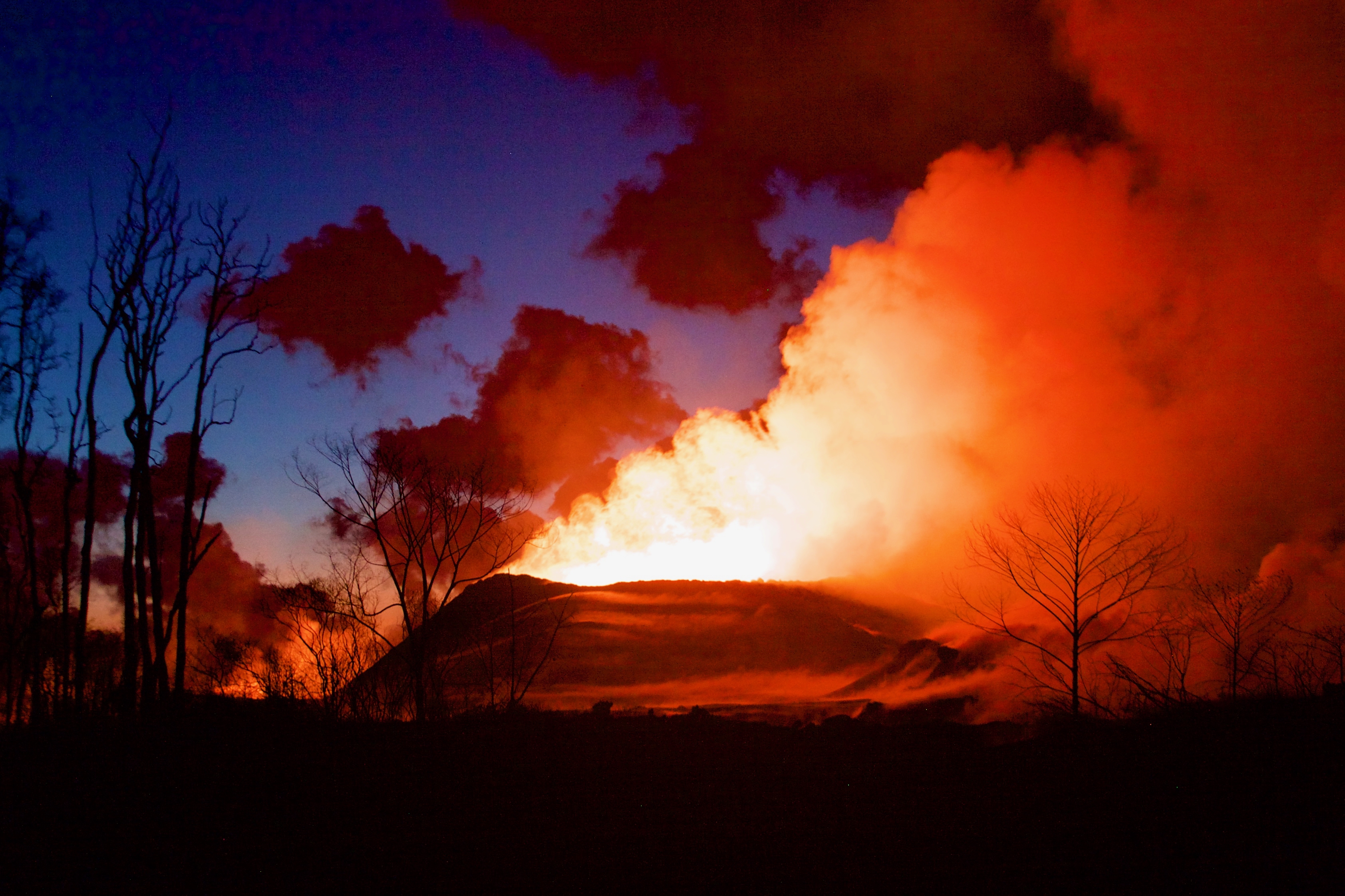
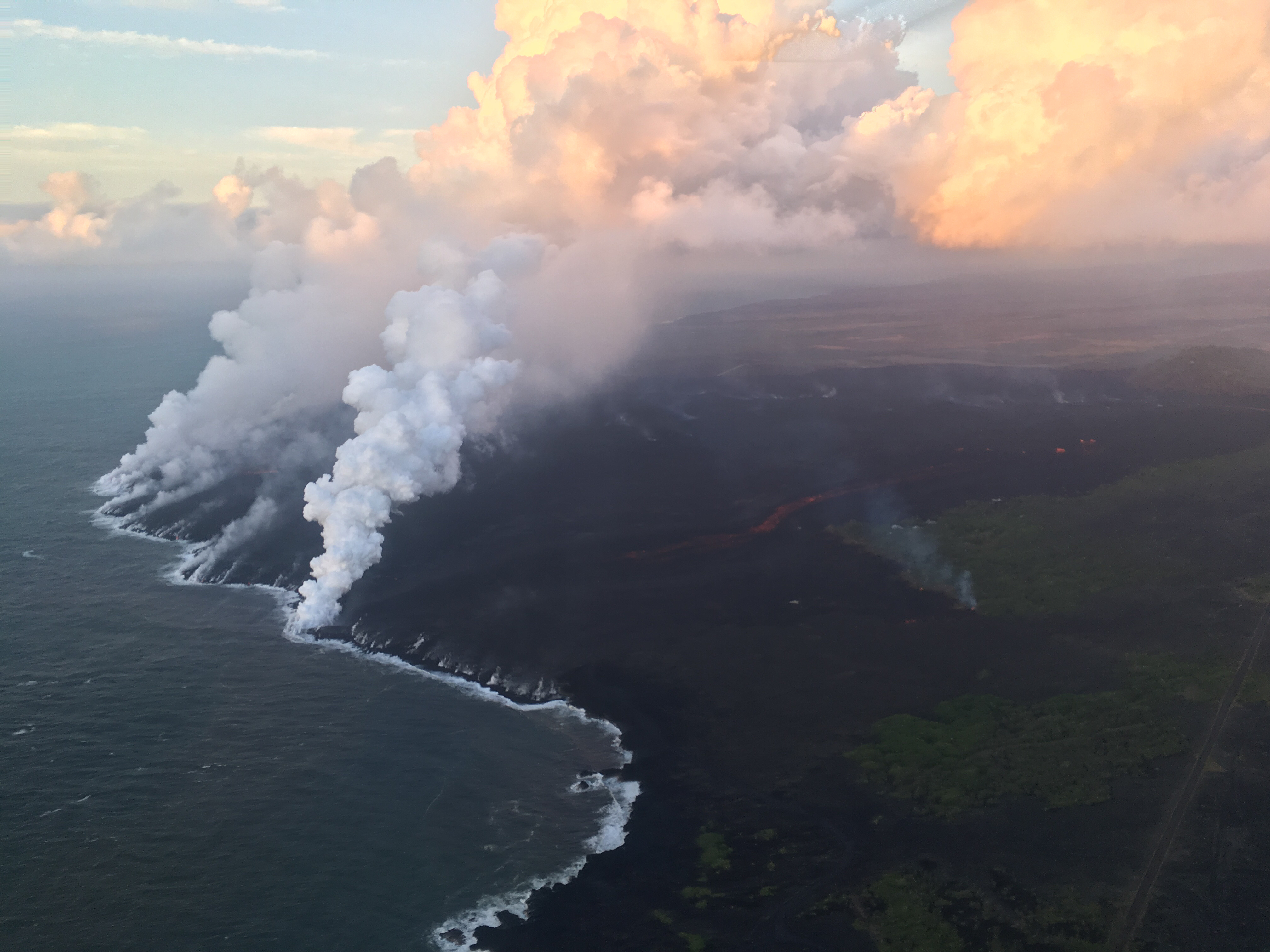
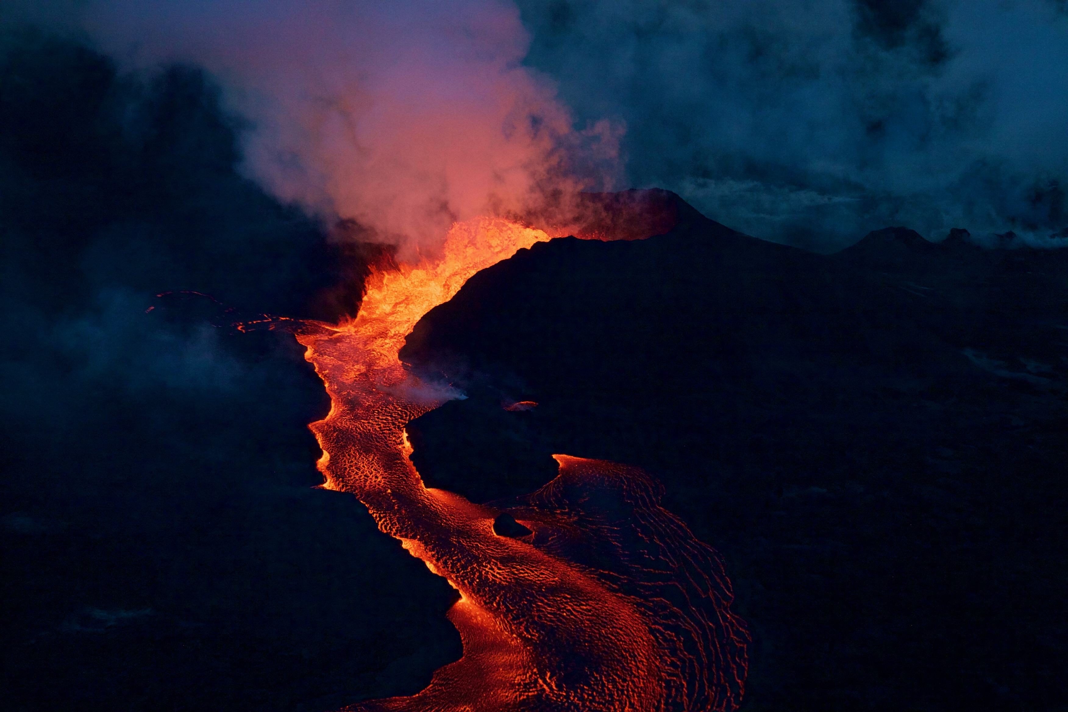
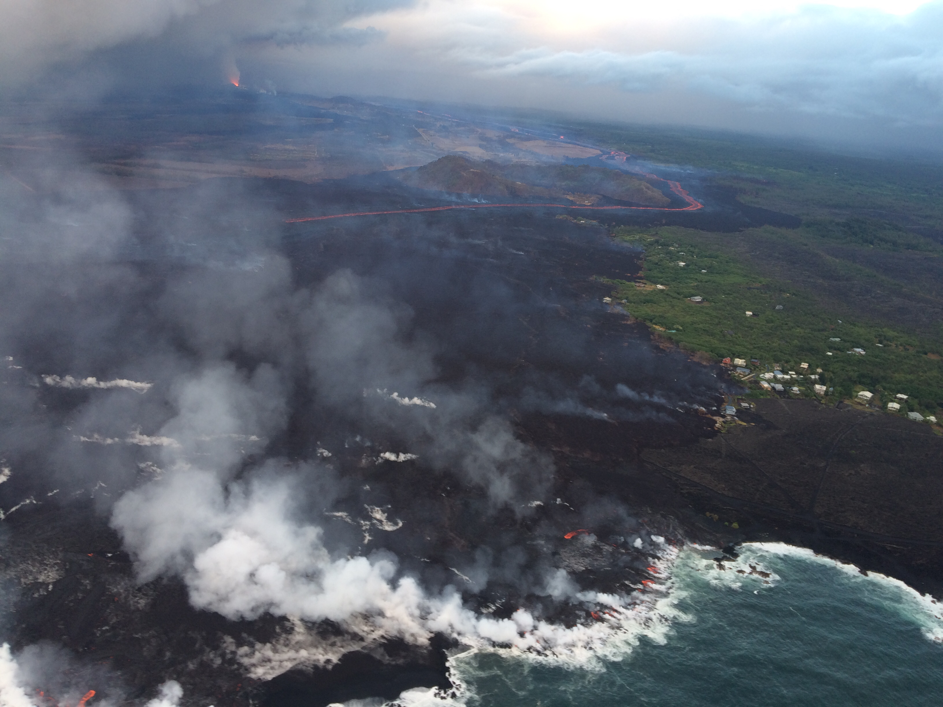
Tina Neal, HVO: Good morning, everyone. Just to give you an update on what’s going on at Kilauea Volcano. In the Lower East Rift Zone, the effusive eruption of lava continues with little significant change from the last few days. The Fissure 8 spatter cone continues to produce a pretty vigorous river of lava in an open channel that heads to the northeast and then turns southeast, then enters the ocean about 8 miles downflow.

One of the interesting things observed by our field crews during the overflight this morning is that the channel system in the lower portion of this lava flow where it ends up into the ocean has gone through some changes. And this is an interesting phenomenon, reorganization, that we’re trying to understand. It appears at times that the channel is very vigorous all the way to the ocean, and at other times it sort of diminishes and just becomes a broad, rubbly front. As of this morning, the channel was mostly on the southern side of the flow, and the margin of the flow is expanding a little bit to the south. So there’s some very interesting channel dynamics going on in this lava flow in the lower portion that really doesn’t [act??] its behavior as it spreads out and enters the ocean.

Continue reading July 9: USGS Morning Conference Call

July 6: Living With the 1% Possibility of Caldera Collapse

USGS, July 6, 2018. Dawn at Fissure 8. (Full-sized)
Today’s Eruption Summary

The Lower East Rift Zone eruption continues pretty much as usual: Fissure 8 feeding a lava river with occasional short-lived overflows. The main lava channel no longer reaches the ocean, but crusts over a half mile from shore and dives into the lava delta, oozing out at multiple points on the northern side. One especially large “ooze-out” makes a short flow on the north side of the flow field near the last few Kapoho Beach Lot Houses, a few of which are hanging on. Fissure 22 is weakly spattering with a weak flow to its east. Today’s summit explosion occurred at 6:04pm, equivalent of M5.3. Thick fog obscured the livestream view.

July 6, 2018, USGS. Ocean Entry at Kapoho. (Full-sized)

So that’s all routine, if a volcanic eruption can ever be routine. The big news today actually took place last night (see what happens when I finish my posts early?):

July 5 Volcano Community Meeting

Thursday evening, there was an important community meeting in Volcano Village. Mayor Harry Kim, the USGS and Civil Defense outlined the extremely unlikely but potentially life-threatening (to people near the summit) possibility of large-scale caldera collapse. I’ve transcribed the meeting here. BigIslandVideoNews excerpted the crucial 4-minute presentation from HVO’s Tina Neal:

Preceding this meeting was a long-expected document from USGS: Volcanic Hazard at the Summit of Kīlauea UpdateWhile the Kīlauea Summit Earthquakes FAQ explained what is happening, this new update to a May 8th report summarizes what the USGS thinks might happen at the summit before this sequence is over, based on the volcano’s distant past.

During the Q&A session, a resident asked about the odds for the worst-case scenario, a large-scale caldera collapse with explosive activity. Harry Kim took the mike from Tina Neal and said, “Like you, we always like to know percentage odds. And she knows; I asked her that. And I’d like to answer because she said, ‘One percent.'” [Tina went on to explain how they arrive at such probabilities; she wasn’t being flippant.]

Another reassuring quote from the Q&A session:

Don Swanson: “I think that the evidence we have today looks to me as if [the subsidence/collapse] is going to be confined to within the caldera, because the outermost circumferential fractures that have been occurring on the caldera floor have not extended outward in the last 2-3 weeks or so. So to me, that suggests that they may be defining the outermost limit of potential caldera collapse.”

USGS: “The WorldView-3 satellite acquired this view of Kīlauea’s summit on July 3. Despite a few clouds, the area of heaviest fractures in the caldera is clear. Views into the expanding Halema‘uma‘u crater reveal a pit floored by rubble. HVO, on the northwest caldera rim, is labeled.” (Full-sized)

Continue reading July 6: Living With the 1% Possibility of Caldera Collapse

July 5: Volcano Community Meeting

Informing the public without panicking them about an extremely unlikely but life-threatening hazard is tricky. So it’s taken the USGS a while to release this document which they’ve been promising the residents of Volcano:

On HVO website: Volcanic Hazard at the Summit of Kīlauea Update [summary: “This document is a guide for understanding current activity and hazard at and around the summit of Kīlauea Volcano. Here, we summarize activity from late April through the present, detail possible future outcomes, and review hazards associated with these outcomes.”]  Presumably it’s called an “update” because it supplements the June 26 “Frequently Asked Questions About Kīlauea Volcano’s Summit Earthquakes” FAQ. [EDIT: No, actually, it’s an update to the May 8th “Preliminary Analysis of Current Explosion Hazards at the Summit“]

This was the chief topic of Thursday’s Volcano Village meeting, led not by the National Park Service this time, but by Civil Defense Administrator Tal Magno.

Here’s the FULL video of the meeting. BigIslandVideoNews excerpted the most important part, HVO Scientist-in-Charge Tina Neal’s 4-minute talk:

Partial Transcript

Continue reading July 5: Volcano Community Meeting

June 28: USGS on Latest Changes to Kīlauea Caldera [Pt. 3 of 3]

This post got long, so I’ve moved the Q&A session to Part 3. Again, I’m transcribing what HVO geologists had to say at the June 28 Volcano Village community meeting.

Part 1 was Kyle Anderson’s talk on seismicity and ground deformation— lots of nitty gritty science— while Part 2 was Don Swanson’s slideshow of some of the visible changes he’s observed within Kīlauea Caldera, with a lot of photos I haven’t seen anywhere else.

Here’s the video of the whole meeting.

Here’s my transcription of the Q&A session. A lot of these questions have already been answered online, but I like hearing direct, personal responses from some of the senior HVO scientists:

Continue reading June 28: USGS on Latest Changes to Kīlauea Caldera [Pt. 3 of 3]

June 28: USGS Talk on Latest Changes to Kilauea Caldera [Pt. 1 of 3]

On Thursday, there was an hour and a half meeting with the USGS, National Park Service and residents of Volcano Village. Above is a video of the whole meeting. As usual, I’m interested in the geology, and so I’ve made a transcript of that part of the meeting. The first half of Kyle Anderson’s talk rehashes the “collapse/explosion” events that we’ve covered before, but the second half has a timelapse of Halema’uma’u from June 1st to June 28th — which I’ve rebuilt frame by frame, since I could just make out the timestamps— plus the latest Digital Elevation Model of Kilauea’s summit showing the slumping not only in Halema’uma’u, but across part of the caldera floor.

Scientist-in-Charge Tina Neal (HVO)

[5:40] [Introductory remarks, greetings and thanks]

[6:20] So tonight you’ll hear from familiar faces, Kyle Anderson and Don Swanson, who will give you an update on what the volcano is doing, what we think is happening, and we’ll touch on this very important question of how long and how big. Those are very hard questions to answer, so let me just preview that we’re not going to give you a wonderful take-away that will solve all that uncertainty. But we’ll do the best we can.

Continue reading June 28: USGS Talk on Latest Changes to Kilauea Caldera [Pt. 1 of 3]

June 28: Media Visits Damaged Park, Views Crater

Early morning USGS photo of Fissure 8 on June 28, 2018. (Full-sized)
Today’s eruption summary

Exactly 8 weeks after the Lower East Rift Zone eruption began in Leilani Estates on May 3, Fissure 8 continues to gush unabated. Its fountains are contained within its 55-meter (180 ft) cone, and this morning’s overflight showed no active overflows.

For the past day or so, the lava river has crusted over on the last half mile to the ocean. This has allowed lava seeps, described by Steve Brantley in his Tuesday evening  talk, to creep into still-molten earlier flows on the northern side of the lava delta. This “lava seepage” is oozing into the ocean along a broad front, encroaching  onto what’s left of Kapoho Beach Lots on the northern edge of the flow:

USGS: “View of the ocean entry (lower left) from this morning’s overflight. Lava was entering the ocean across a broad area primarily on the north part of the lava delta. Upslope along the northern margin of the flow field, lava is still oozing from several points in the area of Kapoho Beach Lots. Fissure 8 lava fountain in the upper left. Note southward bend in the lava channel around Kapoho Crater.” (Full-sized)

At Kilauea’s summit, the most recent collapse explosion occurred at 4:49am this morning, sending up an ash-poor plume about 1000 feet, with the energy release of a 5.3 earthquake. The sides of Halema’uma’u continue to collapse inward and downwards, especially during each explosive event.

Increased seismicity in the hours leading up to each explosion, up to 25-35 small earthquakes an hour, is wearing on the nerves of nearby Volcano Village. The USGS is meeting with them tonight to talk about the ongoing earthquakes, and released an excellent FAQ today: Frequently Asked Questions About Kilauea Volcano’s Summit Earthquakes.”

Local News Outlets Given Brief Tour of Summit

The big news today is that the National Park Service and USGS arranged a brief escorted tour for local news media to the rim of Kilauea Caldera, which has been closed to visitors for 49 days. There was also a half hour press briefing.

So today there’s suddenly a lot more videos and views of what the caldera looks like:

In fact, I’m going to put the news media links before the science segment of today’s post. Boldfaced articles include quotes, videos, and/or photos from the media summit tour.

Continue reading June 28: Media Visits Damaged Park, Views Crater

May 4: USGS Scientist Explains First 24 Hours of Eruption

HVO Scientist-in-Charge Tina Neal gave an EXCELLENT evening briefing on the first 24 hours of the Leilani Estates Eruption, explaining very clearly what was happening and why.

[Big Island Video News, overlaid with video from Mick Kalber flyover]

Powerpoint slide summary of TALK:
  • 6 fissures in first 24 hours — more are expected
  • No lava flows extending more than tens of yards so far — flows are expected
  • Magma intrusion into LERZ [Lower East Rift Zone] is continuing
  • High levels of sulfur dioxide gas [SO2] near fissures and downwind
  • More Magnitude 5+ earthquakes possible as volcano adjusts to intrusion
Excerpts from this Briefing:

Continue reading May 4: USGS Scientist Explains First 24 Hours of Eruption