Today’s Eruption Summary

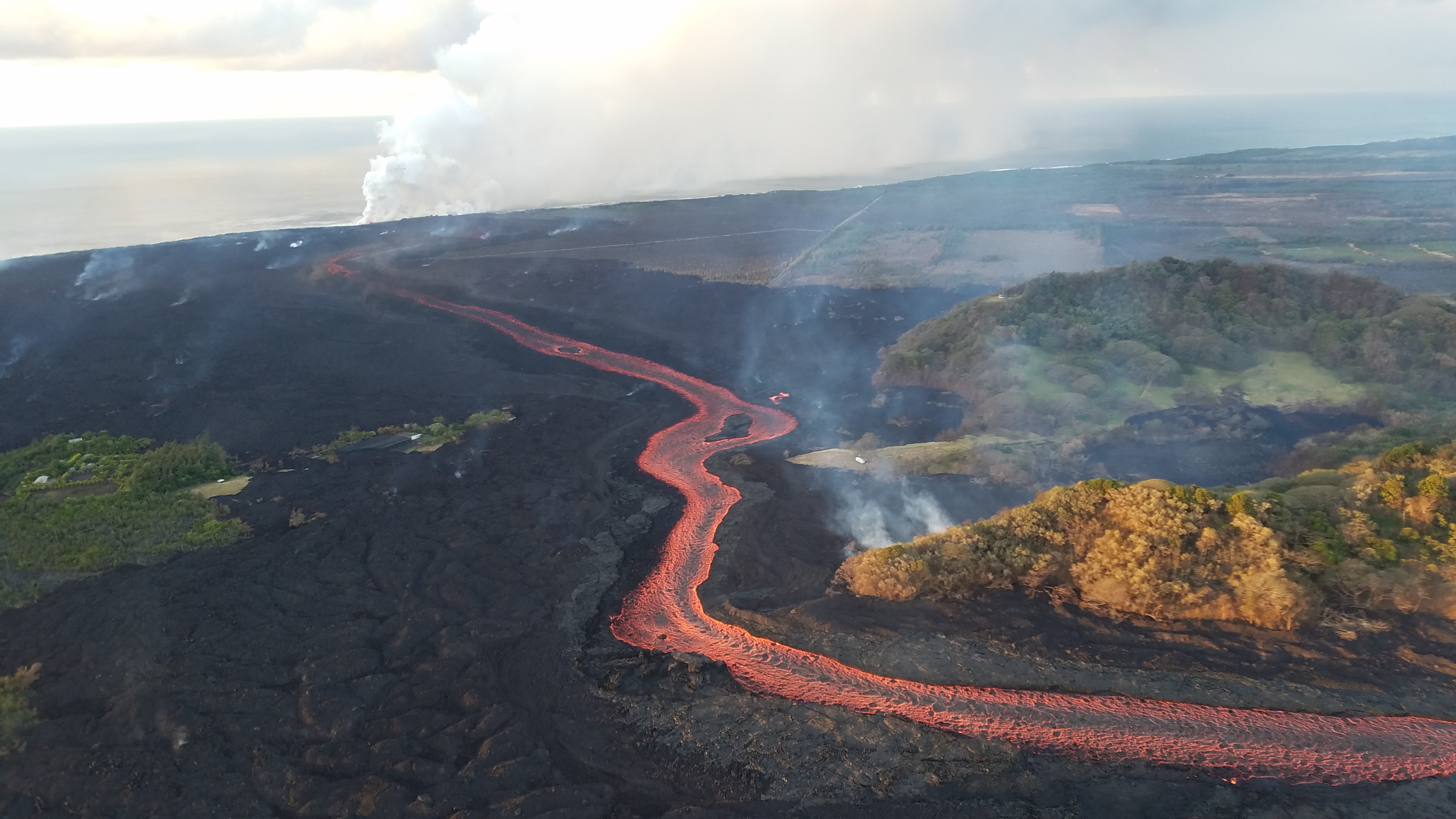
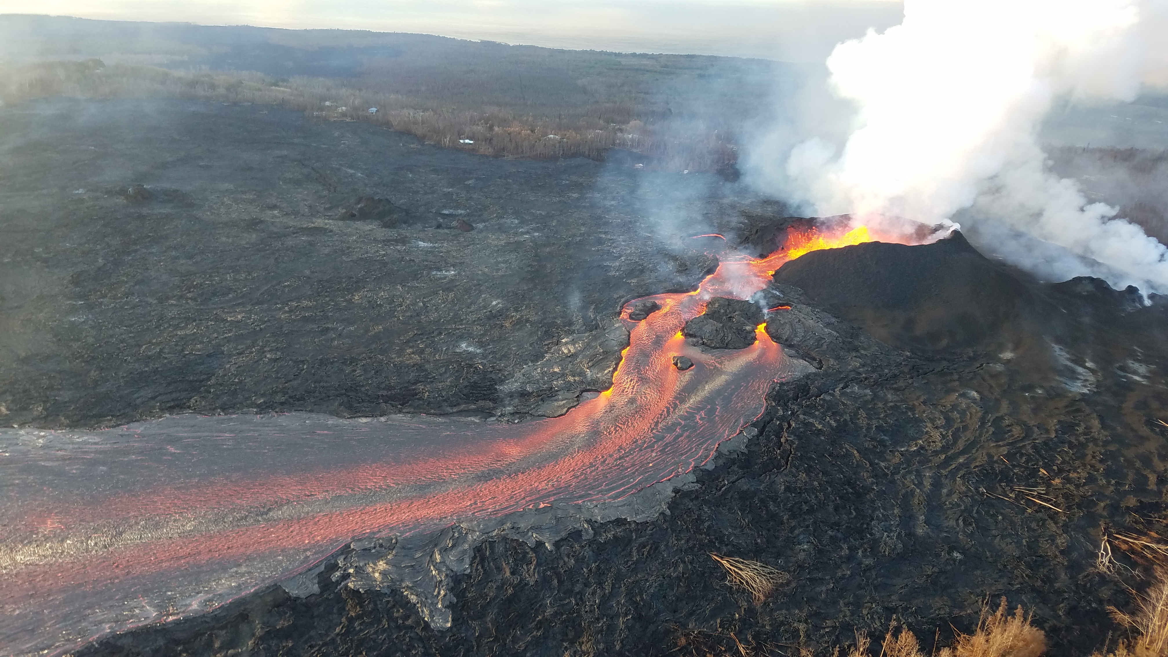
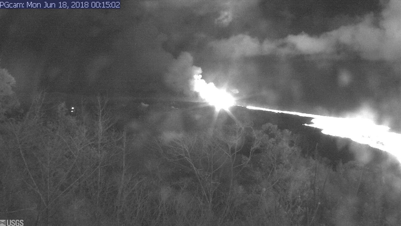
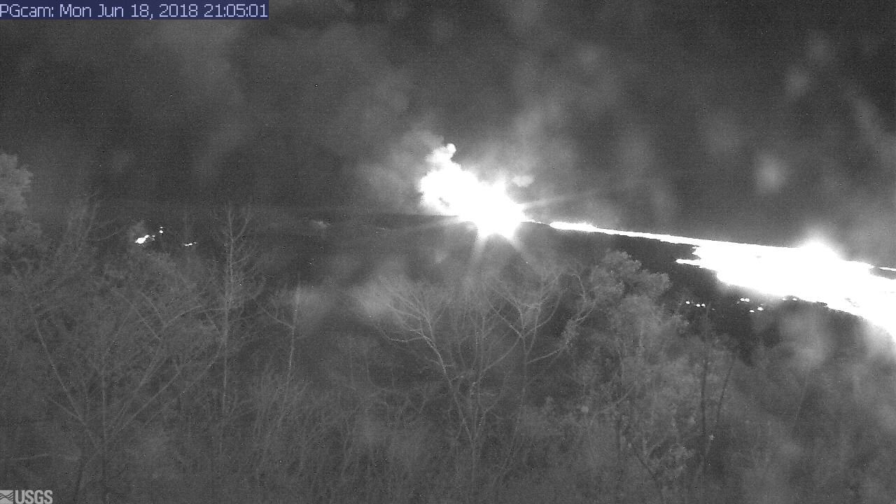
Fissure 8’s still doing its thing, fountaining 150-180 feet overnight with 164 foot spatter cone. The usual minor spillovers on the channel to the ocean. Today the lava’s entering the ocean mostly on the south side of the lava delta in the vicinity of Vacationland. Fissure 16/18 are still oozing, and fissure 6 (the bright spot to the left of Fissure 8 on the LERZ webcam at night) is intermittently incandescent or spattering. Both are “forming small lava flows on top of the existing flows.”

The summit’s daily explosion occurred at 6:12 am, moment magnitude 5.3. It produced a “very small, minor plume that went no more than 500 meters above the ground.” (Brian Shiro in 11AM conference call):
I rewound the Kilauea livestream to watch. The crater was steaming with small white puffy clouds of morning condensation. I saw the window frame vibrate, but the short-lived plume of ash/steam obscured the crater rim, so I didn’t spot any downdrops or rockfalls like we’ve seen for the past few days.
Below: Lots of great photos of summit and LERZ lava field today, and excellent Q&As from USGS on social media.
USGS 1-minute Daily Briefing
Liz Westby, USGS Geologist (transcript)
“The interesting thing about this lava channel is that it is incandescent or glowing orange for nearly its entire length indicating that the lava channel is becoming very efficient about transporting hot lava over that distance.”
I’ve put the half-hour 11AM Media Conference Call in a separate post (recording + notes/paraphrase), or you can listen to the 5-minute abridged version from BigIslandVideoNews.
USGS Photos and Images
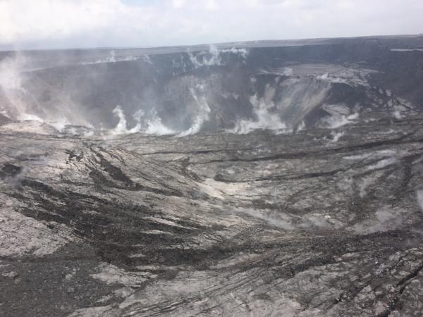
I hope they’ll post the results of the helicopter survey carried out this morning. USGS posted two snapshots from that flight on the HVO photo chronology page:
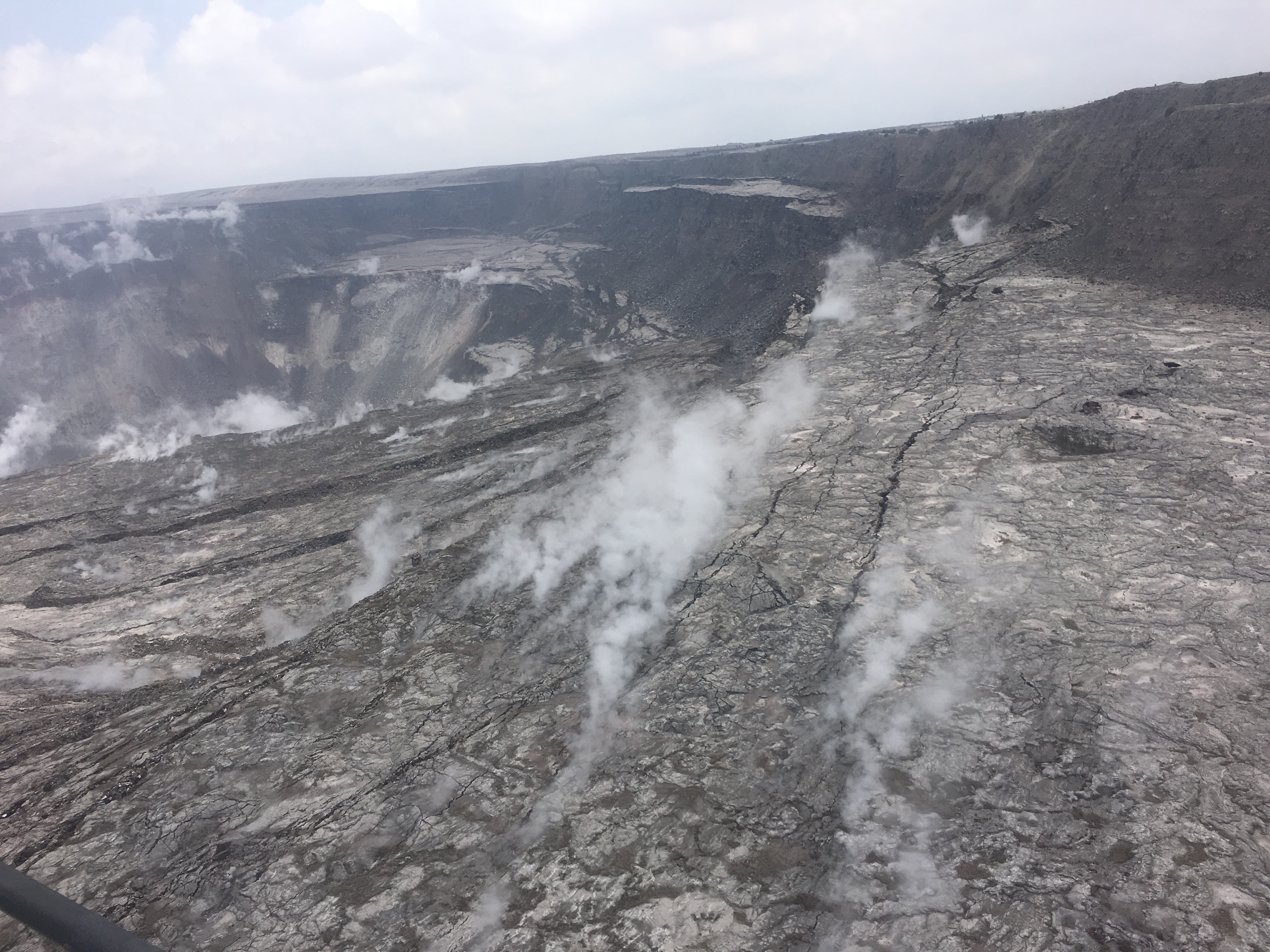
I think the steaming ledge that’s down below the rim at top left is the ledge that dropped on the right side of the livestream on Saturday.
Oh wow. That dropped ledge is in the middle of this photo, and it looks like it’s part of a huge sector of the crater wall that’s dropped as a unit. I think the rockfall towards the middle of the livestream view was coming off the front face of the same block.
Posted on USGS Facebook:
Here’s Fissure 8. I’m afraid that rock that looked like Pele has lost her nose. Also, because scale’s not always obvious, note the dead tree lying at the foot of the cone. Those are what, 100 feet tall?
Slightly different image posted on USGS Facebook:

Is the lava surface reflective enough that reflected sunlight hides the red glow at certain angles? Probably so; there’s an 2015 lava lake photo with the same effect.
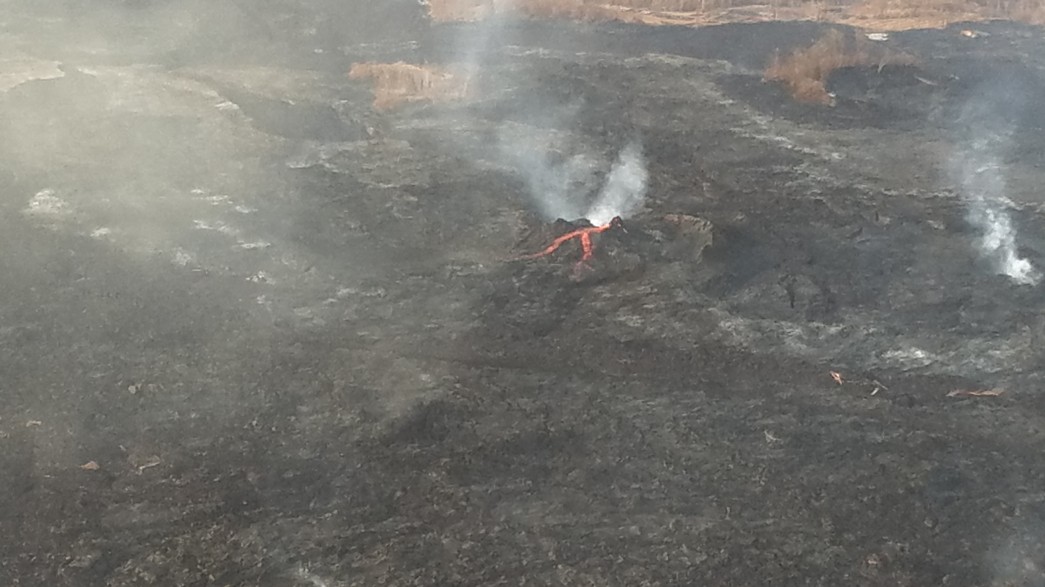
And here’s what Fissure 6 looks like when it’s not just an incandescent speck on the nighttime LERZ webcam:
Here’s a screengrab of the Lower East Rift Zone right now.
I think Fissure 6’s spatter cone is blocking our view of the lava oozing from it, so we’re seeing the lava as two points of incandescence on either side.
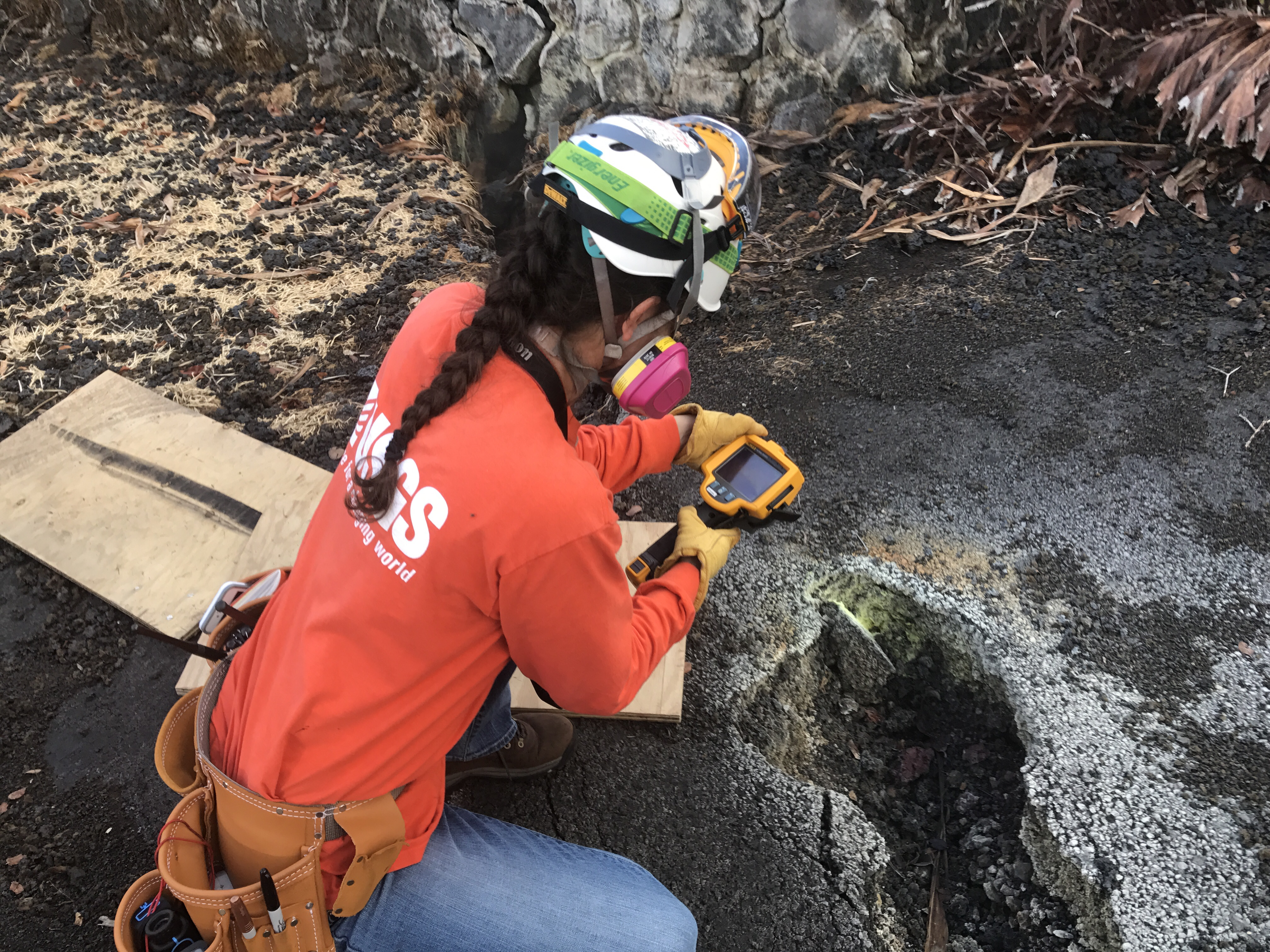
Last but by no means least, USGS posted a rare photo of one of their field geologists who have been working in shifts 24/7 since this eruption started. They don’t give her name; she stands for all of them, I suppose.
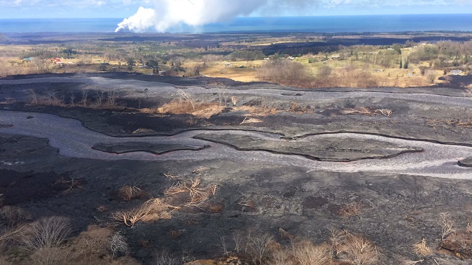
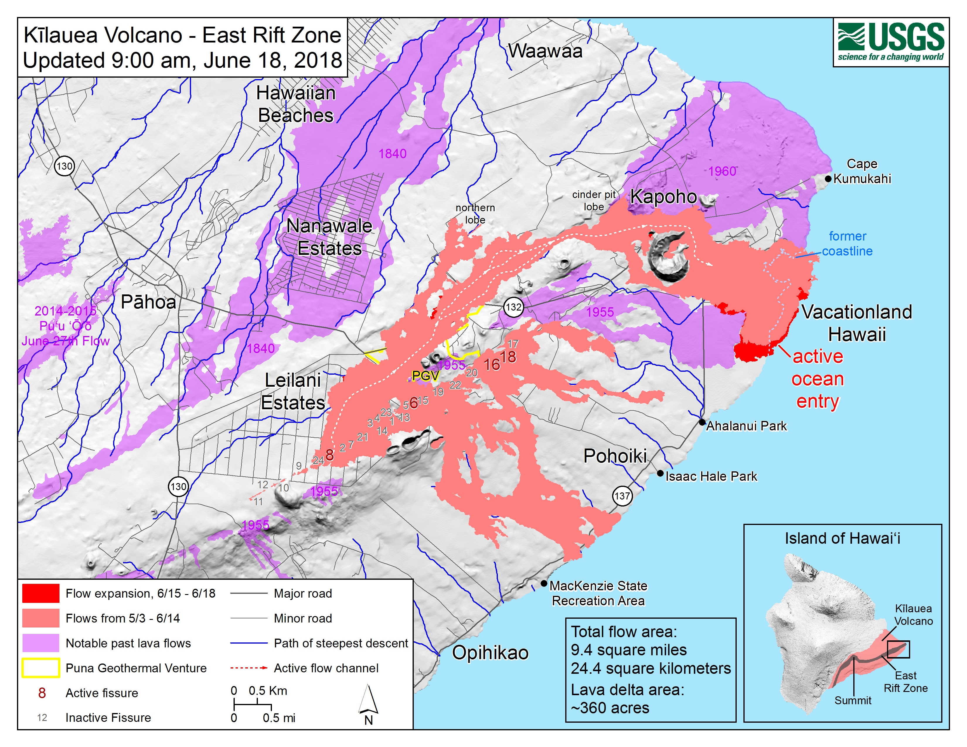
LERZ Lava Field Map for Jun 18
Lava flow coverage: 9.4 square miles
Lava delta: ~360 acres
USGS on Social Media
Here’s Pu’u O’o as I remember it, in all its adolescent pointy glory before many lava flows turned it into a pancake shield shape like a mini Kilauea:
Interesting question. If erupted for ~2 years, fissure8 would probably look similar(ish) to Puʻu ʻŌʻō at about that time – a rather large cinder cone downwind with a vent on the side. Here's Puʻu ʻŌʻō @ 2 yrs (high fountain, 1460 ft) and 3 yrs (740 ft cinder cone). pic.twitter.com/nZgIXUp7Pf
— USGS Volcanoes🌋 (@USGSVolcanoes) June 19, 2018
Good question about ocean entry: “Does the lava go all the way down to the ocean floor as the delta expands or does it form a shelf that goes more out than down?”
Where it's shallow, lava can go all the way to the sea floor and is somewhat stable. But as the floor drops away, lava entering the ocean builds a delta on top of unstable lava fragments on the steep submarine slope. This delta can collapse unexpectedly: https://t.co/FvZkPRWhv2 pic.twitter.com/4qi7VHraZE
— USGS Volcanoes🌋 (@USGSVolcanoes) June 18, 2018
Followup USGS tweet: “While the waves that result from a delta collapse can be dangerous locally, they aren’t big enough to travel far (or really even be considered tsunamis). They are dangerous to anyone nearby, but like laze, don’t have far-reaching effects.”
USGS seismologist Brian Shiro said today that the lava entry at Kapoho is in a shallow area, unlike where Pu’u O’o was sending its lava, so there’s a higher chance the new Kapoho Point (my name for it) will be stable.
Answering another ocean-entry question: “The lava flows on Hawai’i are affecting a very small area of its coastline. While the loss of the Kapoho tide pools is a big blow to the island, it’s not having widespread effects. @himb_soest can probably comment more on the impacts.”
Additionally: “Even when it becomes safe to enter the ocean in that area (which it won’t be until the lava stops flowing there), @USGS_Volcanoes isn’t the group that will survey the damage. We’re more comfortable with fissures than fish.”
Moving up to the summit and down into Halema’uma’u’s depths…
The lava that was in the Halema'uma'u lava lake is now in the East Rift Zone. Some of it may now be erupting at the fissures in the Lower East Rift Zone. There is no magmatic connection to Mauna Loa, and historically, Mauna Loa is quiet when Kilauea is more active.
— USGS Volcanoes🌋 (@USGSVolcanoes) June 19, 2018
In answer to the usual “OMG is this going to do a catastrophically larger thing than it’s doing?” question: “The slumping is completely within @Volcanoes_NPS. The associated earthquakes are affecting Volcano and the Golf Course homes, and there are some earthquake-related cracks on Hwy 11.”
It may be time to sound the bugle for North Pit GPS station on the former north rim of Halema’uma’u:
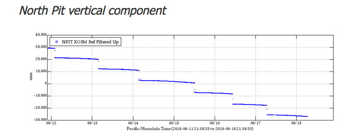
That's meters. It's dropped 90 meters, and we may have just lost it….
— USGS Volcanoes🌋 (@USGSVolcanoes) June 18, 2018
And here’s an explanation for something that was puzzling me, a GPS station that keeps going WHEEEE south and then WHEEE north, which, coupled with the tilt data of its neighbor, made me think a block kept leaning forward, then straightening out again when it dropped:
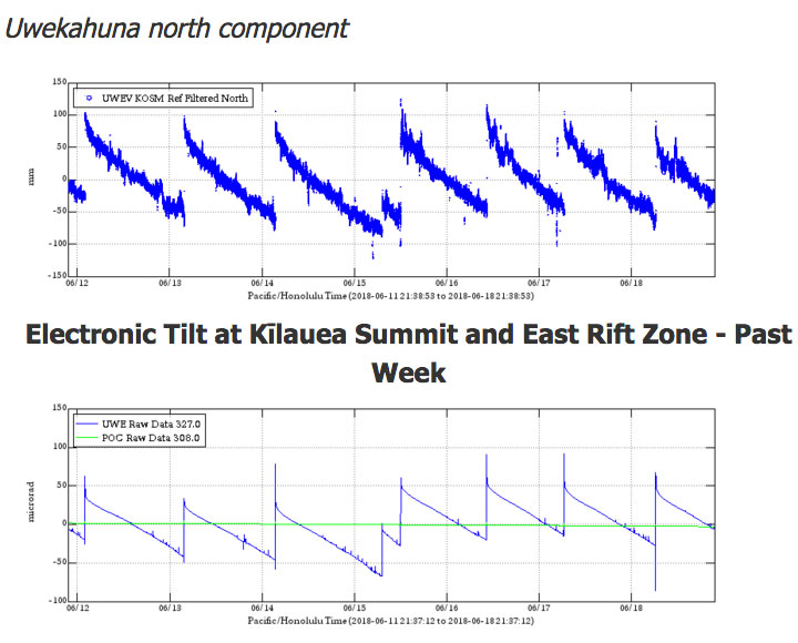
I’m not sure if my idea about leaning/tipping is correct, but apparently it’s somewhat like that:
“If talking about the signal at UWEV GPS, it’s because the station is slowly moving toward #Halemaumau (not actually down, but south). Explosion “rights” the station & forces it back north. Today’s Type A didn’t produce much ash, but still strong explosion.”
Day by day, the summit of Kīlauea volcano subsides around Halema‘uma‘u Crater. This series of images spans June 1 to 10 from our summit wide-angle webcam mounted on the tower of the Hawaiian Volcano Observatory. Further slumping occurs during every explosive event. Right now, we're calling the larger explosions "Type A". To be classified as such, our scientists see four distinct geophysical signals: seismic, infrasound, = tilt, and GPS. Recently, the explosions have been occurring once per day and have been registering as a magnitude 5+ earthquake. However, they're not typical earthquakes at all – there is no major fault-rupturing event. Instead, pressure builds up beneath the rubble pile that is choking the conduit and is released as the explosion.For additional photos and videos visit: https://volcanoes.usgs.gov/volcanoes/kilauea/multimedia_chronology.html#volcanoes #usgs #Kilauea #KilaueaErupts #Halemaumau #volcano #KilaueaEruption #SummitEruption
Posted by USGS Volcanoes on Monday, June 11, 2018
From Civil Defense / State Agencies
Civil Defense alerts same as usual.
The mayor’s office issued a worrisome bulletin. Harry Kim was hospitalized this morning with a “Mild Heart Attack.” He’s had three since April, plus walking pneumonia. I wouldn’t normally advocate bed restraints, but that man NEEDS TO REST. (The trouble is, he’s one of those energizer bunny people anyway, and then on top of tha he’s the most experienced person in the emergency operations center, since he was head of Civil Defense when Pu’u O’o lava flows covered Kalapana.)
From Hawaii Volcanoes National Park
FAQ: How much damage has the park sustained? Ongoing seismic activity continues to degrade buildings & infrastructure. Earthquakes have cracked parking lots & roadways. The overlook at Jaggar Museum has sustained significant fractures. Find out more: https://t.co/LOLvJtAZ0N pic.twitter.com/bVq6BlwRv5
— Hawaii Volcanoes NPS (@Volcanoes_NPS) June 18, 2018
In their article/FAQ, they include a map showing the expected maximum range of “large boulder rockfall” and “marble- to pea-size rockfall.” This was probably drawn up in the first weeks of the eruption, when steam explosions were a concern but hadn’t yet started. I was assuming ballistics were no longer an issue since we’re well past steam explosions in an exposed lava lake, and what’s coming up now looks like gases and modest amounts of ash. But I suppose that doesn’t rule out rocky projectiles or the chance of more vigorous explosions.
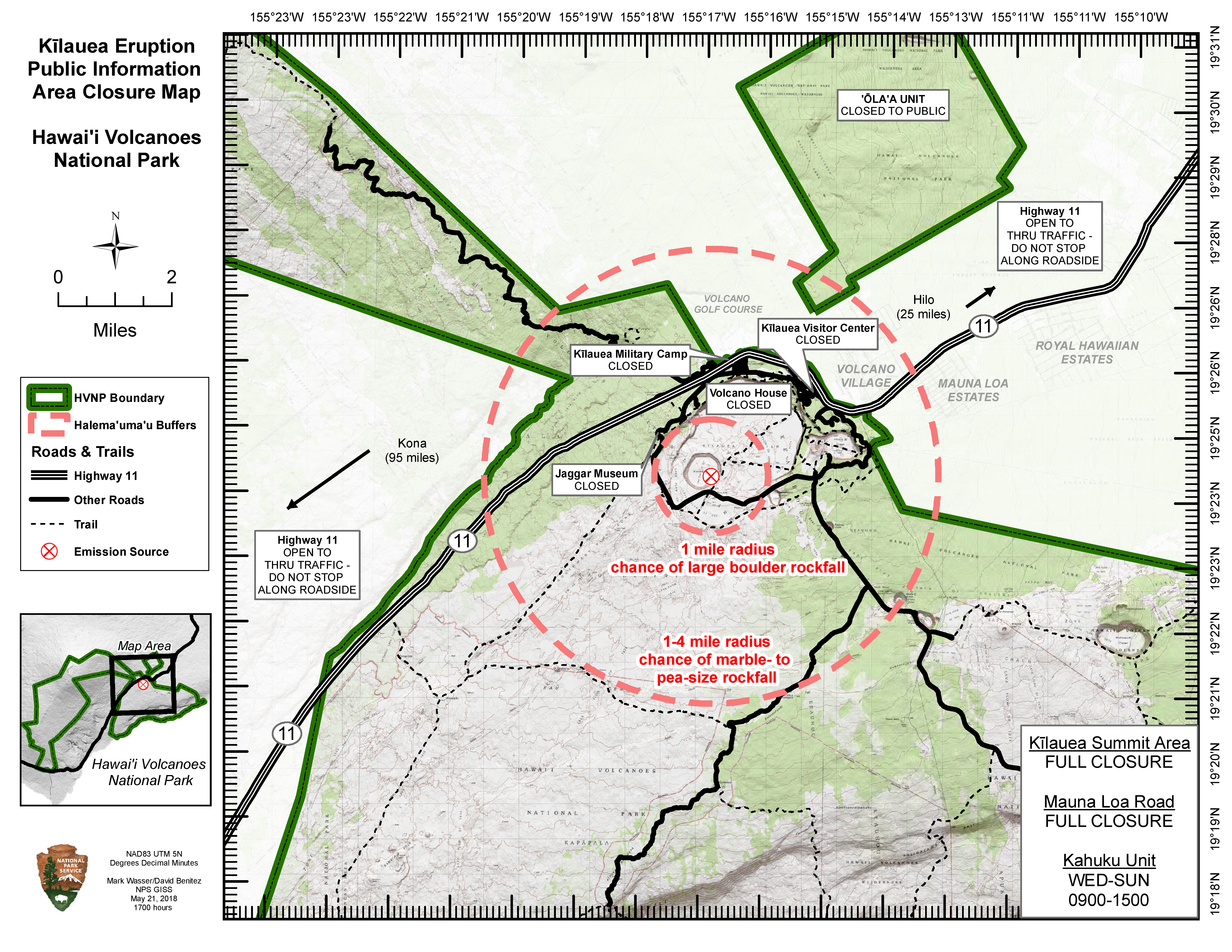
I didn’t realize one could still drive through the park (but not stop) on Highway 11.
From Hawaii National Guard
Good overflight footage — I think morning of June 16.
From Local News Outlets
- HTH: “Lava continues; disaster relief, free health care available”
- HSA: “Big Isle Mayor Harry Kim hospitalized with another heart attack”
- HNN: “Big Island farmers brave lava, toxic fumes to harvest crops”
- HSA: “Free health clinic opens at Keaau High School”
- HTH: “So far, 730 register at Disaster Recovery Center”
- HCB: “Big Island: Hawaii’s Last Hippie Holdouts May Not Survive the Eruption”
- HNN: “‘Wait and see’: For lava evacuees, the right help can be hard to find”
- HNN: “Displaced residents assess next steps as lava destroys homes, land“
- BIN: “Hawai’i Island Residents Foster Hundreds of Animal Evacuees”
- HPR: “How and Where Should We Rebuild After Kilauea Eruption?”
- HPR (audio only): “Insuring Homes in High Lava Hazard Areas”
- HTH: “More alleged lava loiterers cited”
#LeilaniEstatesEruption #KilaueaVolcano UPDATE: Hundreds of people from Leilani Estates, Lanipuna Gardens & Kapoho have passed through the FEMA Disaster Recovery Center since Friday – all hoping for assistance from federal officials https://t.co/qgosM421XP @HawaiiNewsNow #HINews pic.twitter.com/dMyXBaFbfb
— Mileka Lincoln (@MilekaLincoln) June 19, 2018
Moment of Aloha
Dispatches From Volcano today reflects on the changing vistas of the new crater with excellent screencaps— one very clear view— plus a good photo of Halema’uma’u Crater from 2005, pre-lava-lake.
Mick Kalber LERZ Overflight
Clear skies and gorgeous views of the lava channels again today.
Photography/social media Roundup
I’ve posted so many photos today we’re kind of maxed out, nevertheless…
We took this image the morning before the towns of Kapoho and Vacationland were covered by lava. And this is our last photo of Kapoho Bay 😭 pic.twitter.com/914NkqpY4u
— the Weatherboy (@theWeatherboy) June 19, 2018
And this is what that "peninsula" looks like now. We shot this by boat where lava mixes with salt seawater to create a plume of hydrochloric acid. What was Kapoho Bay is behind that laze plume. pic.twitter.com/cVpUHS9SVG
— the Weatherboy (@theWeatherboy) June 19, 2018
" Nothing beside remains. Round the decay
Of that colossal Wreck, boundless and bare
The lone and level sands stretch far away.”#KilaueaVolcano 🌋 pic.twitter.com/7bFTIVXRxk— David Bressan (@David_Bressan) June 18, 2018