August 5: Pele Taking It Easy This Week

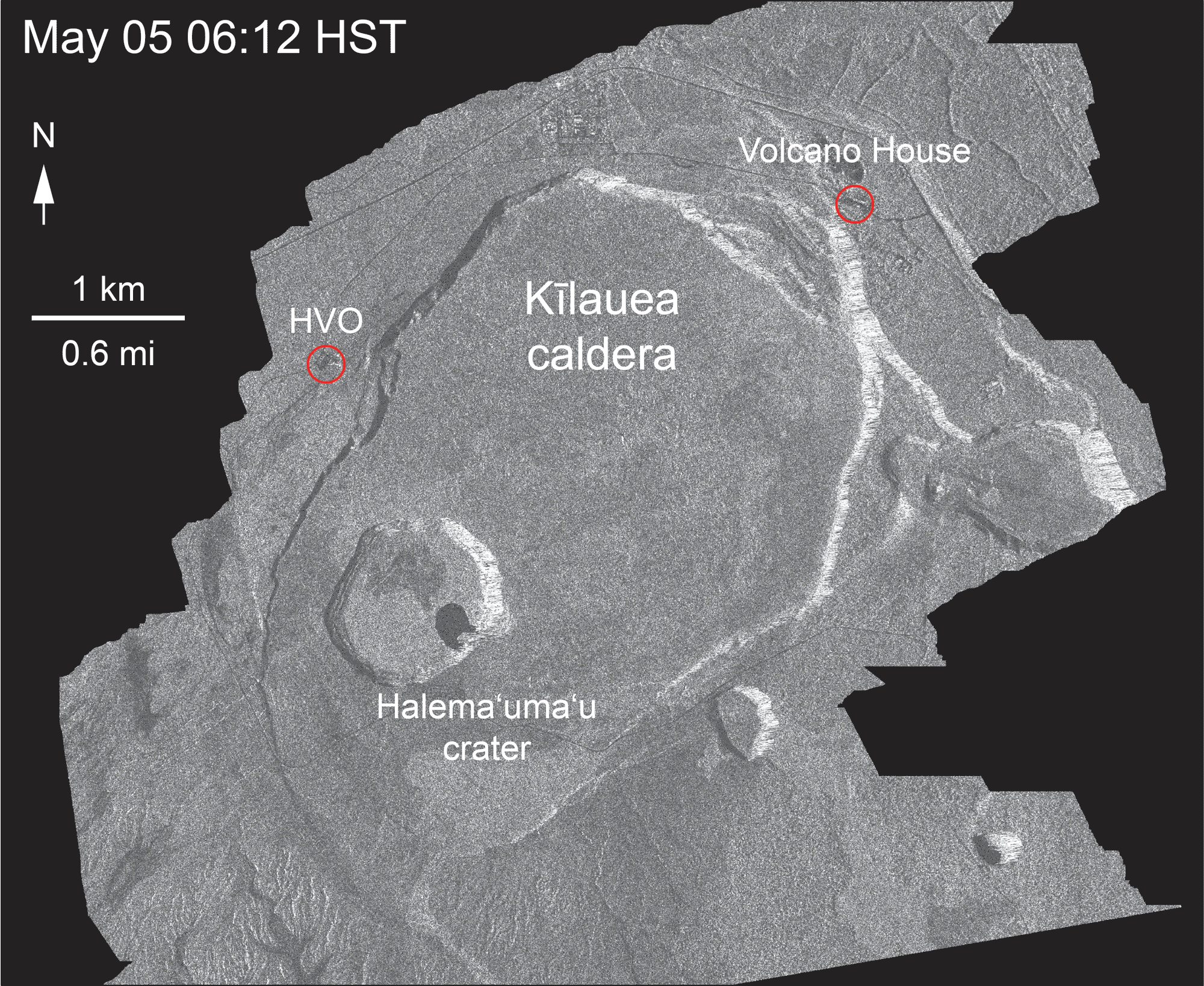
“Since May 16, 2018, the crater depth has more than tripled and the diameter has more than doubled.” ~ HVO

Kilauea summit changes, 2018. USGS: “Here’s another ‘then and now’ look at Halema‘uma‘u (view is to north). At left, Halema‘uma‘u, as we once knew it, and the active lava lake within the crater are visible on April 13, 2018. At right is a comparable view captured on July 28, 2018, following recent collapses of the crater. The Hawai‘i Volcanoes National Park Jaggar Museum and USGS-HVO can be seen perched on the caldera rim (middle right) with the slopes of Mauna Loa in the background.” (Full-sized)
Current Eruption Summary

Volcanic activity has decreased over the past few days, at both the summit and down in the Lower East Rift Zone. However, as HVO warns us (and has stated many times), eruptions wax and wane, and can even stop and start up again. So we don’t yet know whether Pele’s winding down or simply taking a breather.

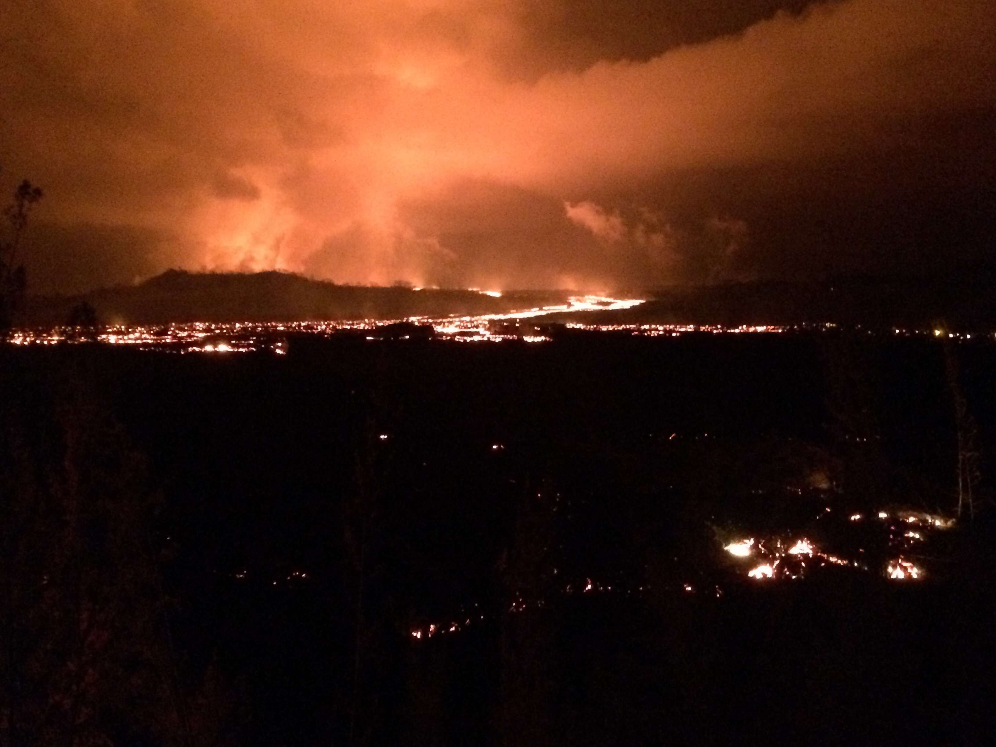
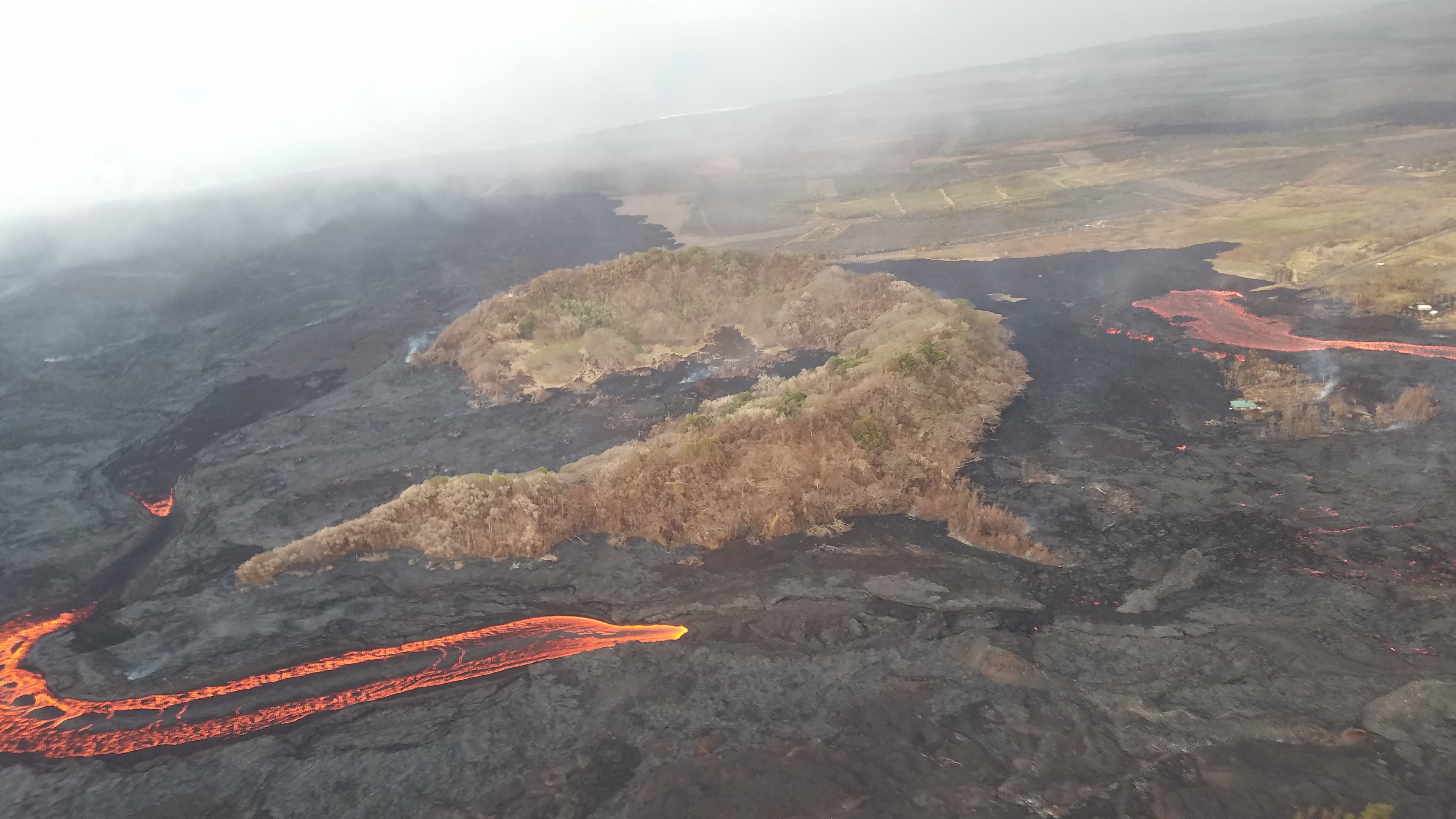
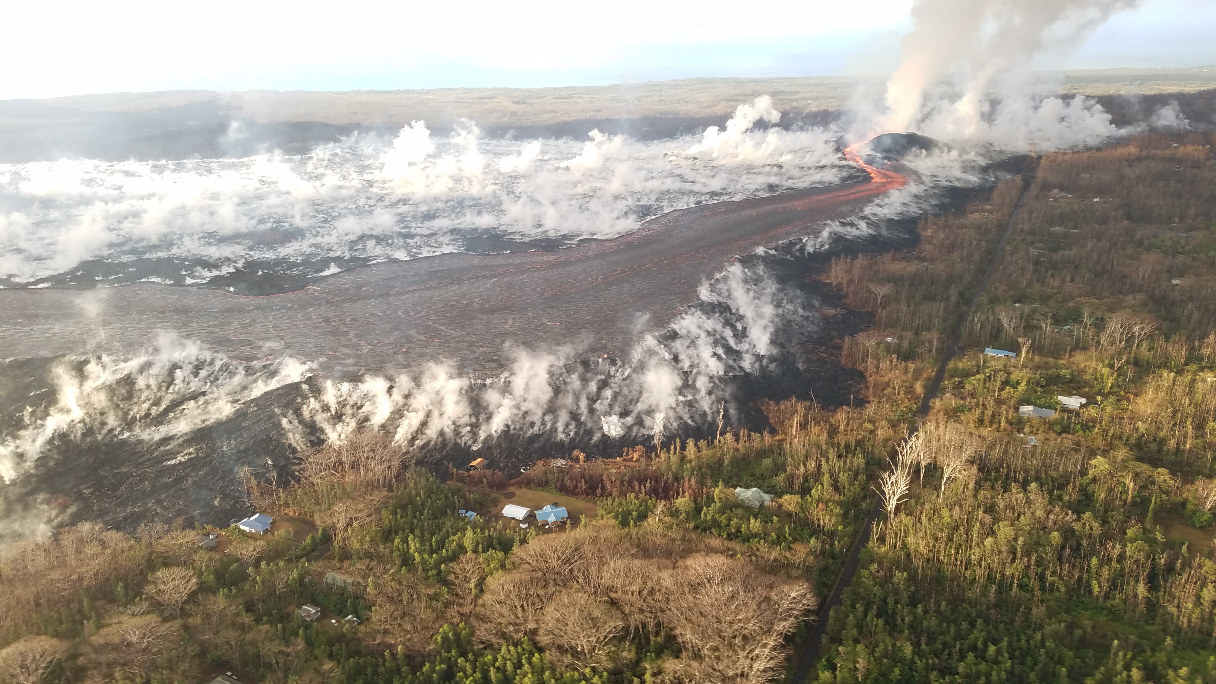
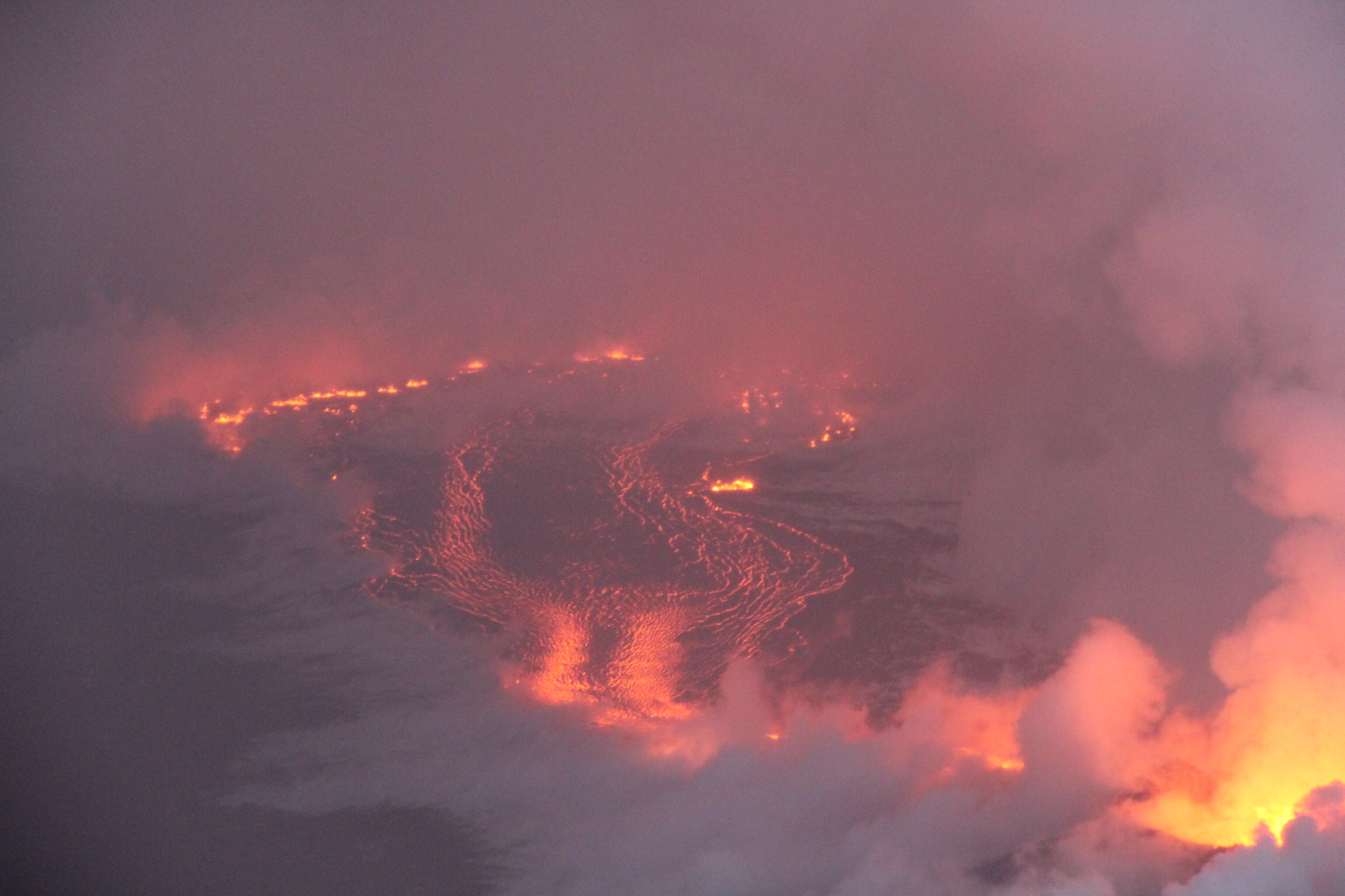
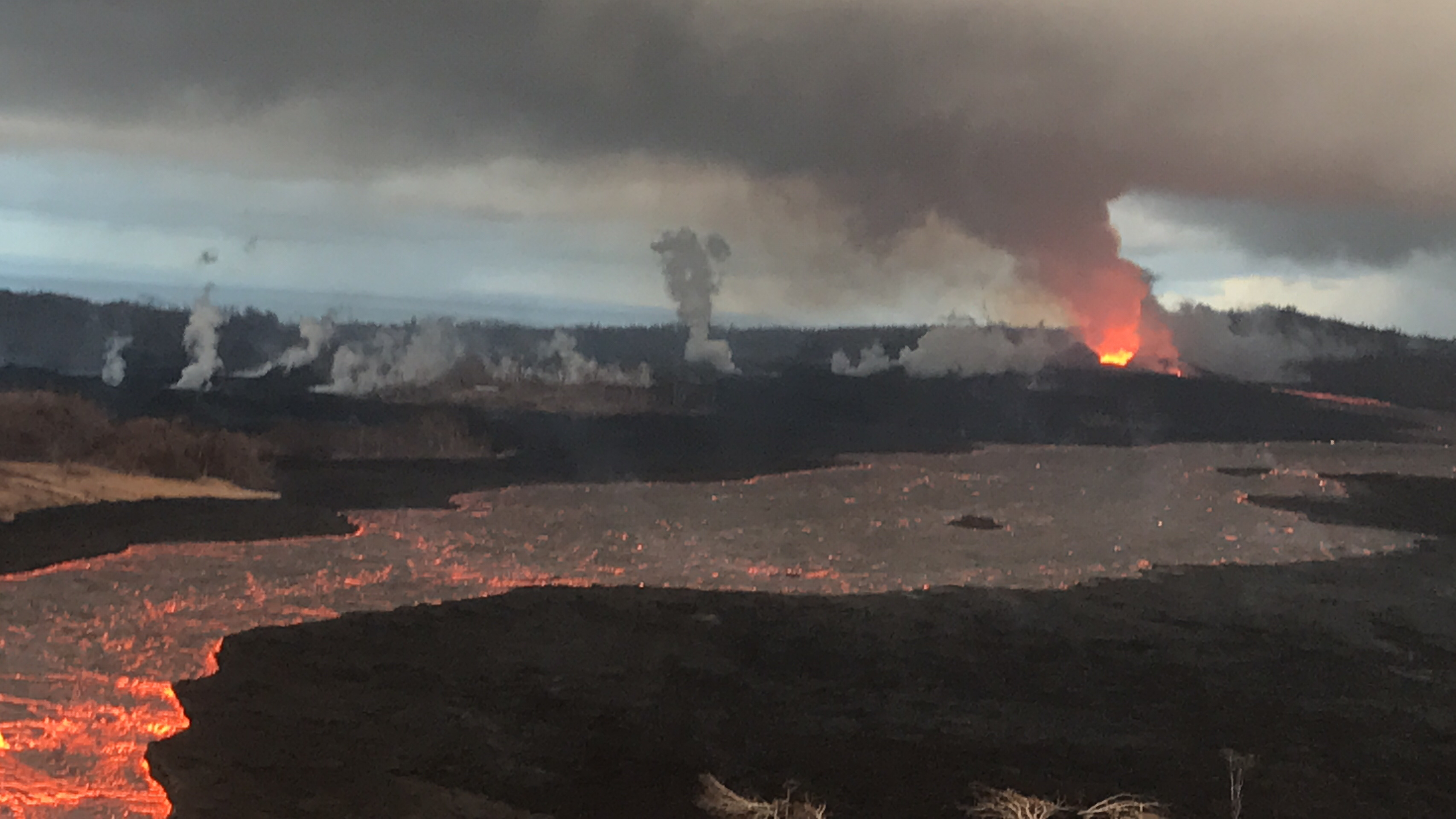
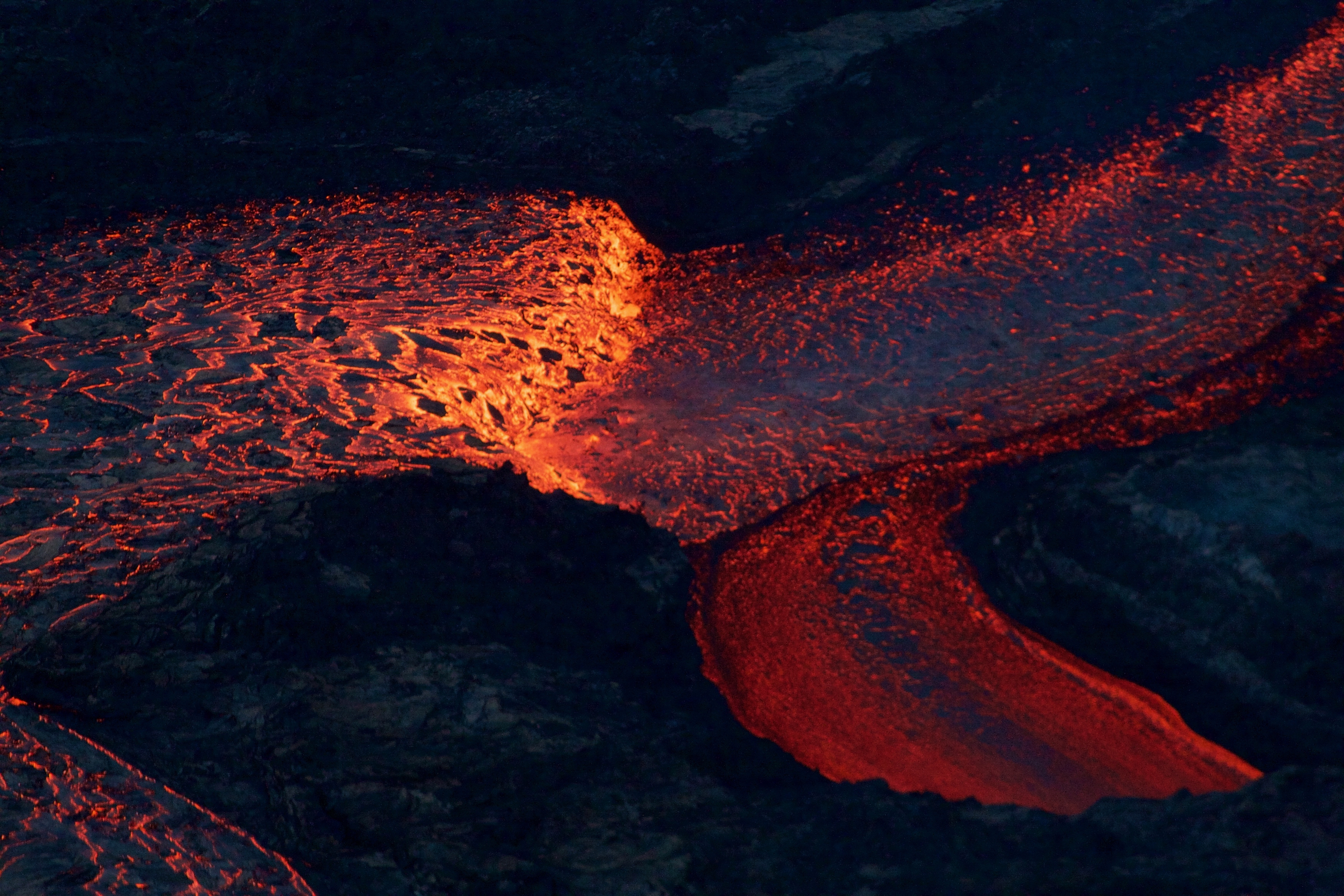
But for the moment, at least, Fissure 8 is putting out much less lava than before— in fact, this morning (August 5) its level is so far down that it’s barely feeding the channel. Lava levels were already lower and sluggish, and today the river is mostly crusted over and/or moving as thicker, crumbly a’a flows. However, blockages downstream are still causing overflows and breakouts.

“View of the fissure 8 cone and spillway from HVO’s overflight early this morning, during which geologists observed eruptive activity that was much less vigorous than in past days.” (Full-sized)

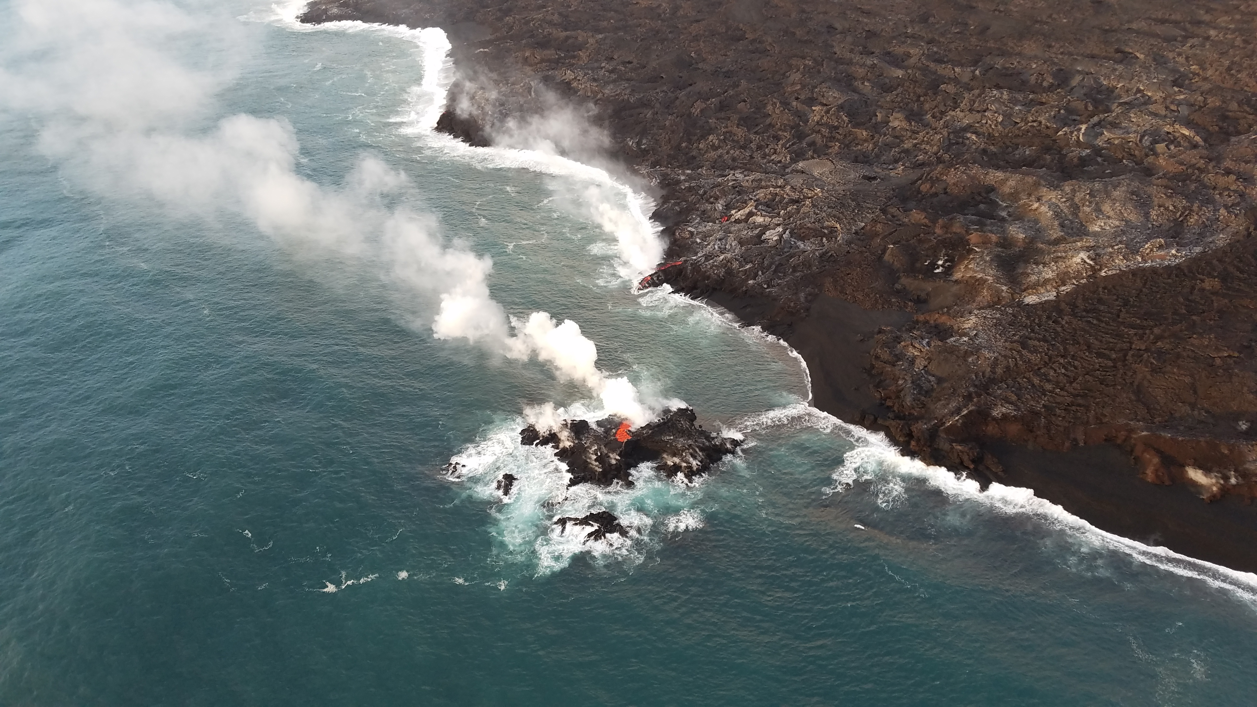
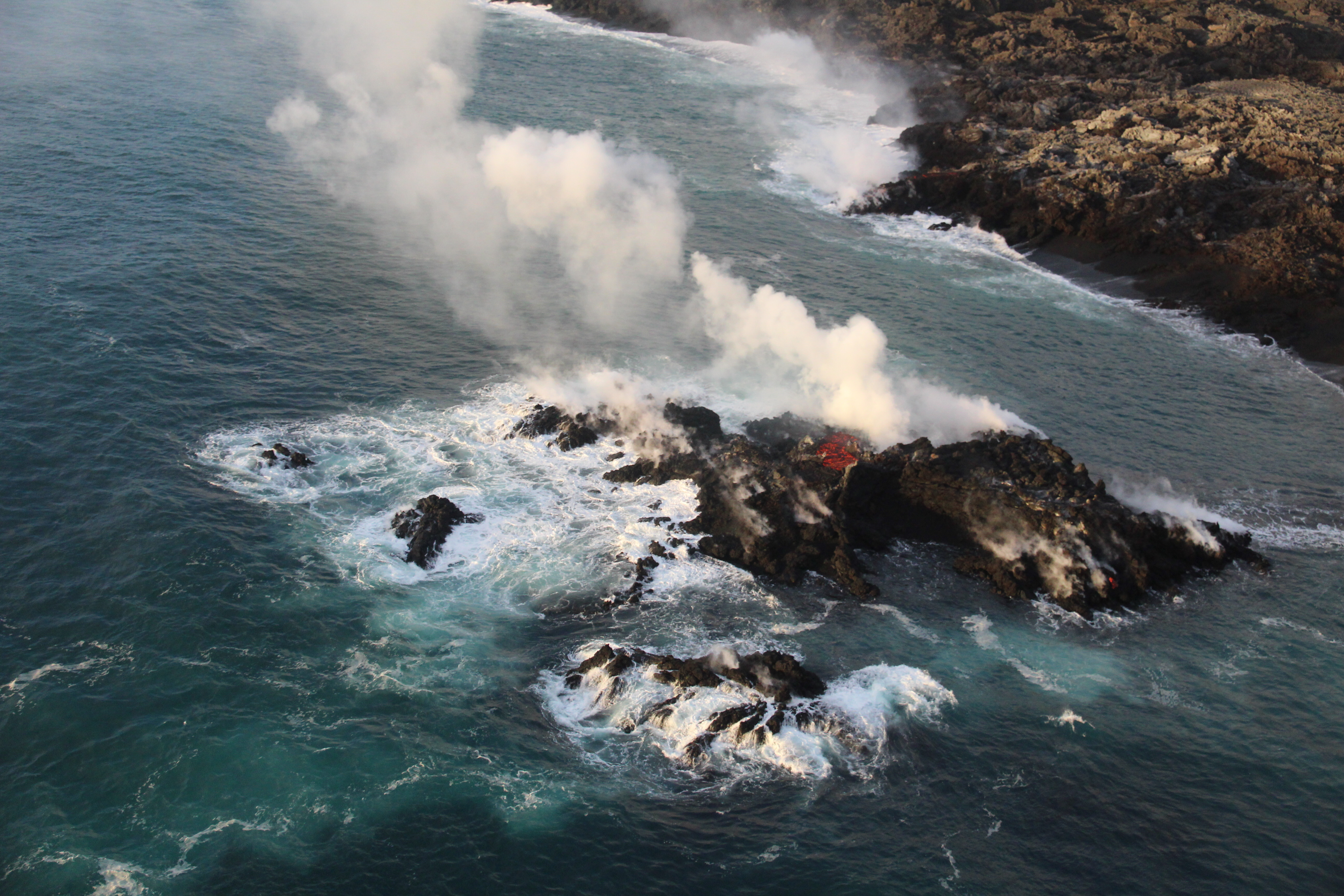
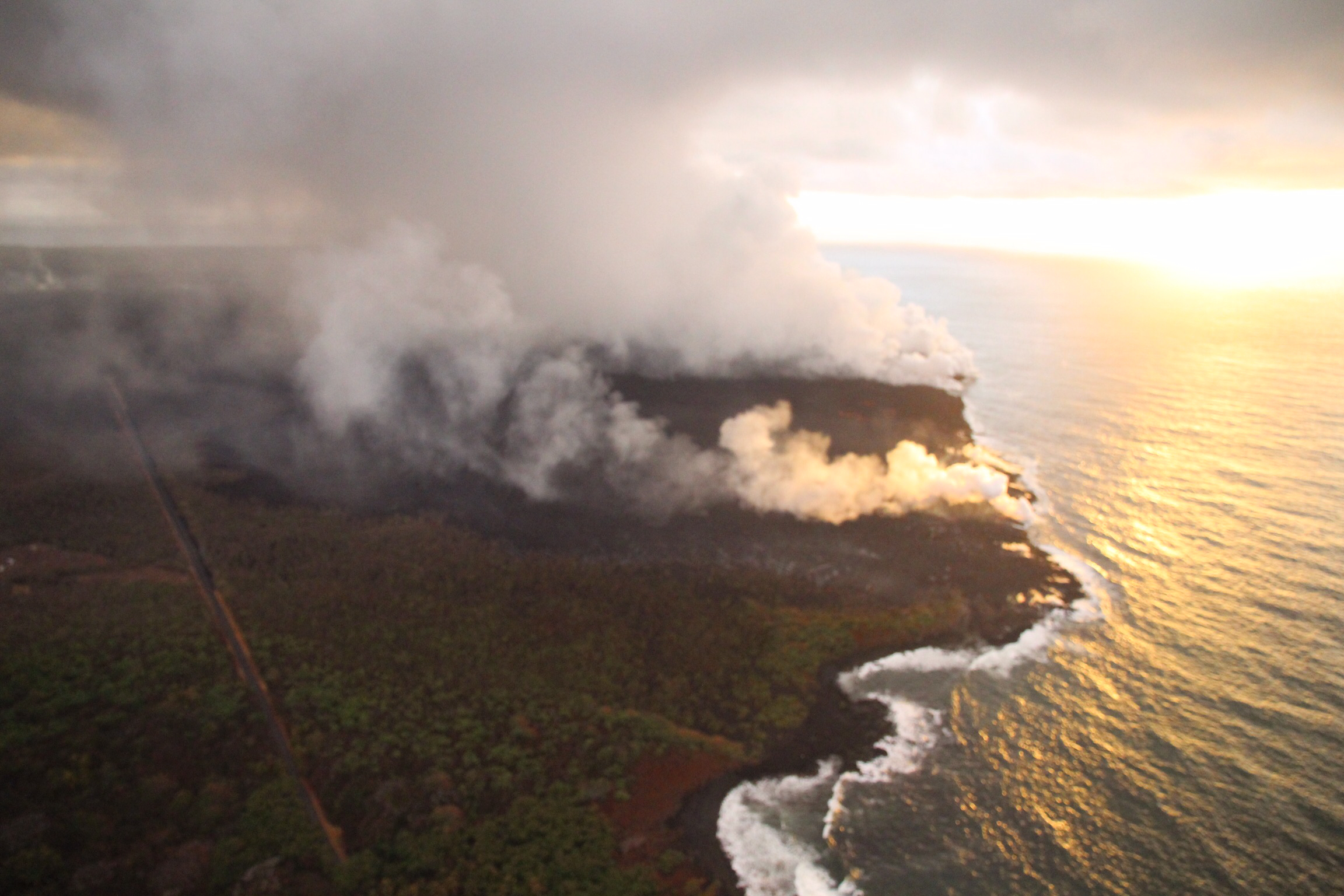
Despite the slowdown at the source, lava continues to ooze into the ocean along a long section of the southern flow front. It’s edged a little bit closer to the boat ramp and local park that’s become a symbol for residents mourning the loss of so many other beloved places:

August 5, 2018. USGS: ” A diffuse laze plume afforded a clear view of Isaac Hale Beach Park and the ocean entry, which was being fed across a broad front by viscous pāhoehoe. Lava was oozing laterally, but was still about 70 m (230 ft) southeast of the Pohoiki boat ramp as of this morning.” (Full-sized)

Lava tour boat operator Ikaika Marzo did not see any signs of slowdown at the flow front this morning, and he reported that lava has claimed claimed another popular local surf spot called “Dead Trees.”

At the summit, intervals between collapse events are lengthening. As of 5 pm August 5, it’s been over three days since the last summit collapse event. Today’s mini-update on HVO’s website states:

Rates of seismicity and deformation at summit and lava output from fissure 8 have decreased since most recent collapse event at 11:55 am HST August 2. Too soon to tell if the decrease will persist. Hazardous conditions remain.

Lower East Rift Zone USGS lava map as of 10 am, August 3. (Full-sized)
Friday, August 3 USGS Thermal Map of Lower East Rift Zone as of 12:30 pm. (Full-sized)
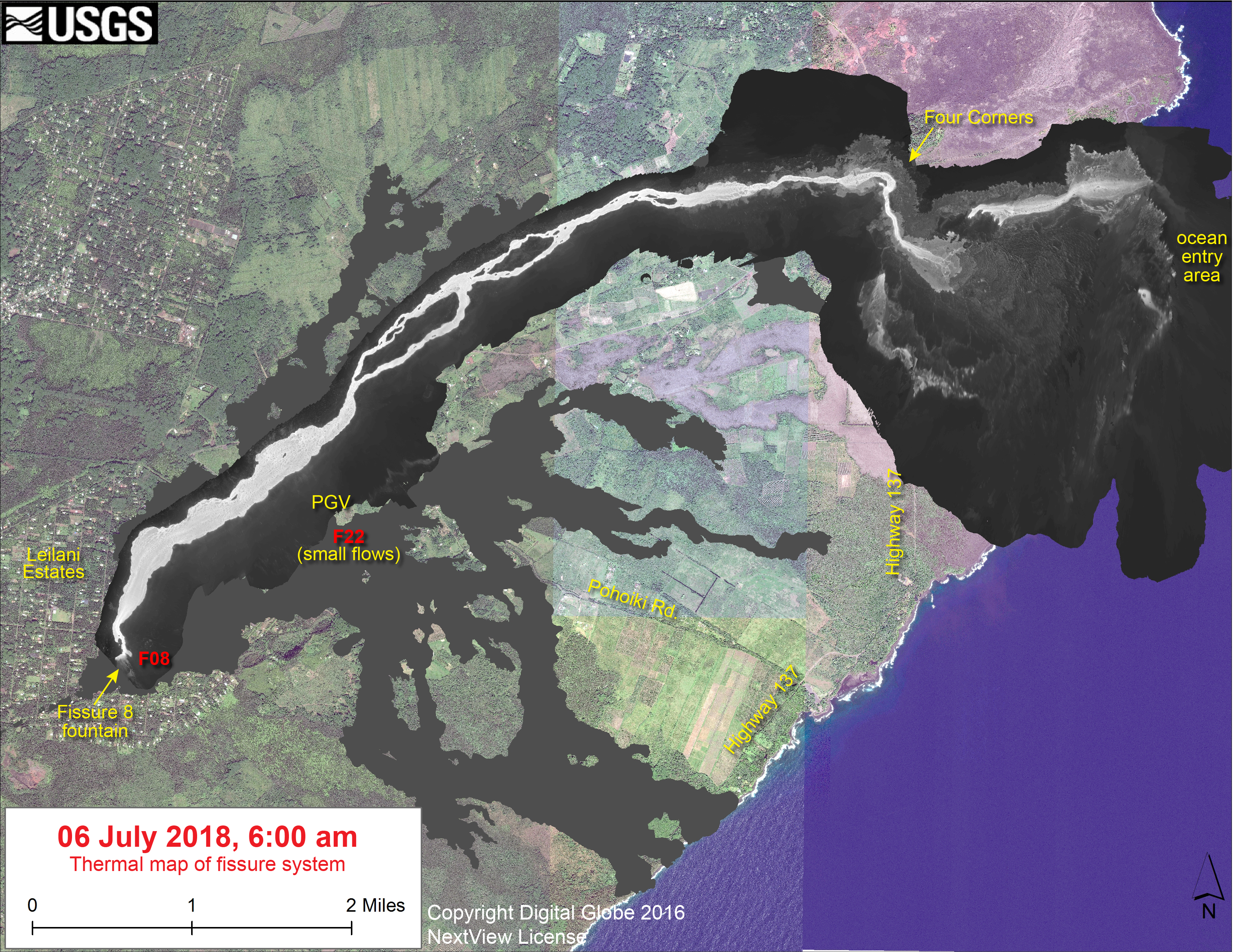
Latest Satellite Imagery

The most recent scenes, acquired on August 1, 2, and 5, show little overall motion, which is consistent with the slowing of deformation in the summit area over the past few days. — HVO

Kilauea Caldera satellite radar imagery, May 5-August 5, 2018. (Full-sized)
Volcano Watch, August 3

And on August 3— before today’s significant lava decrease at Fissure 8— HVO posted out its weekly Volcano Watch column:

Outline of the rest of this post:
  • Summary of USGS presentation at Thursday Volcano Village meeting
  • Review of USGS eruption images from past few days (plus video)
  • News and Kilauea-related information from other official agencies
  • Kilauea-related headlines from local news media
  • Overflight photos/videos of LERZ from @Hotseathawaii, etc
  • USGS Q&A about eruption (and recent signs of change) on social media

Continue reading August 5: Pele Taking It Easy This Week

July 28: Kīlauea LIDAR Data – 3D Renders by Fumihiko Ikegami

Remember how OpenTopography.org recently posted LIDAR surveys of Kilauea from 2009, June and July 2018?

Well, volcanology PhD student Fumihiko Ikegami (@fikgm on Twitter) has been creating great 3D renders using this data.  Click on images below for large-size views of each render.

You can turn, zoom, and view this 3D model from any angle:

Before it all started— years ago, Ikegami created these using the 2009 data:

Continue reading July 28: Kīlauea LIDAR Data – 3D Renders by Fumihiko Ikegami

July 24: Steve Brantley Talk at Pahoa Community Meeting

USGS/HVO Deputy Scientist-in-Charge Steve Brantley has been giving weekly 10-minute slideshows at Tuesday evening Pahoa Community Meetings. Here’s last Tuesday’s.

Transcript:

Good evening. Thank you for coming out tonight. I have just a short presentation to provide for you this evening, and I invite you to come back to the back of the room at the end of the meeting. I have copies of the report that we put out on Thursday of last week, so you’re welcome to take a copy. Please, one per household. And I’ll draw attention to—  the centerpiece of that report is a map. And I have a copy of the map back there that we can talk about if you’d like.

So the activity this past week has not changed significantly, either at Fissure 8 or along the lava channel or at the summit. The summit keeps dropping during these episodic earthquakes, where parts of the crater floor drop 2-2 ½ meters, 7-8 feet at a time, and also overall slow subsidence.

Continue reading July 24: Steve Brantley Talk at Pahoa Community Meeting

July 13: Hawai’i Has a New Island (For Now)

July 13, 2018. USGS: “A tiny new island of lava has formed on the northernmost part of the ocean entry. During this morning’s overflight, HVO’s field crew noticed the island was oozing lava similar to the lava oozing from the broad flow front along the coastline.” (Full-sized)
Today’s Eruption Summary

Fissure 8’s lava flow has settled into its new course, turning right just before Kapoho Cone and proceeding south-southeast to the ocean in a strong channelized a’a flow. Some lava, apparently following the earlier paths (lava tubes, maybe?) to the sea, is still squeezing out of the broad 6km (3.7) mile lava delta to the north of the new ocean entry.

A fascinating footnote: while the northern “ooze-outs” are weakening, a tiny lava island popped up just offshore of them last night, and it is itself oozing lava:

July 13, 2018. USGS: “A closer view of the new “island,” which was estimated to be just a few meters offshore, and perhaps 6-9 meters (20-30 ft) in diameter. It’s most likely part of the fissure 8 flow that’s entering the ocean—and possibly a submarine tumulus that built up underwater and emerged above sea level.” (Full-sized)

Fissure 22 has stopped spattering. However, many inactive fissures were steaming today, “possibly due to the increasing humidity in the area.”

Today’s summit collapse occurred at 7:06pm HST, with the energy equivalent of a 5.3 earthquake, as usual. HVO is setting up a new livestream from Volcano House, but it’s not fully operational yet, so we made do with the ailing HVO webcam today (video clip).

July 13, 2018. USGS: “View of Halema‘uma‘u and Kīlauea caldera just before 8:00 a.m. HST today, as seen from HVO’s observation point near Volcano House. Gusty winds were blowing quite a lot of rock-fall dust, visible both within and along the rim of the crater.” (Full-sized)

It’s been fascinating watching geologists collect data, figure things out, and incorporate these discoveries into their daily Kilauea alerts. Just as the HVO team  started predicting the summit’s cyclical collapse/explosions, now they’ve started predicting (or at least watching for) Fissure 8’s lava surges and possible spillovers a few hours after each summit collapse. Sure enough:

Also, we’ve got a new view of ever-expanding Halema’uma’u Crater in Kilauea’s summit caldera this morning:

July 13, 2018. USGS: “USGS scientists captured this stunning aerial photo of Halema‘uma‘u and part of the Kīlauea caldera floor during a helicopter overflight of Kīlauea’s summit this morning. In the lower third of the image, you can see the buildings that housed the USGS Hawaiian Volcano Observatory and Hawai‘i Volcanoes National Park’s Jaggar Museum, the museum parking area, and a section of the Park’s Crater Rim Drive. Although recent summit explosions have produced little ash, the drab gray landscape is a result of multiple thin layers of ash that have blanketed the summit area during the ongoing explosions.” (Full-sized)

I couldn’t find a comparable aerial photo with the observatory and Jaggar in shot, but this 2009 photo of Halema’uma’u is facing in approximately the same direction. (Look for Crater Rim Rd behind the crater on the left, and note the parking lot obscured by the lava lake’s plume in 2009— lava lake, parking lot, and part of that road collapsed into the crater in June.)

Continue reading July 13: Hawai’i Has a New Island (For Now)

July 12: Explosive Ahalanui Ocean Entry

July 11, 2018, 6:00 pm – Kilauea's east rift zone overflight: The large channelized flow to the west of Kapoho Crater,…

Posted by Extreme Exposure Fine Art Gallery on Thursday, July 12, 2018

Today’s Eruption Summary

Sadly, yesterday afternoon was the end of Kua O Ka La Charter School and Ahalanui Warm Ponds. The flow that diverted west of Kapoho Crater created a channelized a’a flow all the way to the ocean. There is now a strong ocean entry at what used to be Ahalanui Beach Park. There are still multiple “ooze-outs” along the northern lava flow front spanning former Kapoho Bay— it’s now 6 km, 3.7 miles across— “despite no visible surface connection to the fissure 8 channel.”

[Below: USGS 6am overflight, July 12: Fissure 8 perched lava channel, new diverted channel around Kapoho Crater, Ahalanui ocean entry.]

The level of Fissure 8’s lava river was low above Pohoiki Rd in the hours before the summit collapse. USGSVolcanoes posted at 7:17pm today that they observed an increase in Fissure 8 activity following the 2:42pm summit collapse (mag 5.3, here’s video), raising its level again. But there were no overflows, apart from some “small channel breaches south of the ocean entry.”

Speaking of the ocean entry, Bruce Omori of @HotSeatHawaii captured a startling offshore laze/steam/lava explosion just offshore:

USGS field teams reported “no visible activity” at Fissure 22 or any other fissures besides 8.

Today, USGS also posted a 3-month timelapse of Halema’uma’u from the HVO panorama cam, April 14-July 11:

This is another busy news day.

Continue reading July 12: Explosive Ahalanui Ocean Entry

July 10: Regrouping After Yesterday’s Overflows

USGS: “View from Bryson’s quarry around 11:45 p.m. HST last night looking uprift past Halekamahina (an older ash cone) to fissure 8, which is creating the glow behind the cone. Bright areas indicate incandescent lava, with the brightest areas showing the trace of the lava channel. A blockage in the channel produced overflows that are seen as spotty incandescence. Lava flows in the foreground are near the base of the quarry cinder pit.” (Full-sized)
Today’s Eruption Summary

The chaos of yesterday has settled down a bit. Stormy weather has moved out, most of the overflows up-channel from Kapoho Crater have stopped, and lava is has returned to the main channel leading to the ocean, although not at the same volume as before. Yesterday’s breakout flow towards Cinder Road stalled last night. As of 4AM this morning, the only overflows still active were on the south (brown) side of the lava channel, including a new side-flow on the west side of Kapoho Crater (ocean is in the background haze):

July 10, 2018, morning overflight. USGS: “Aerial view of Kapoho Crater looking toward the south-southeast. Part of the lava channel became blocked just upstream of Kapoho Crater yesterday, diverting flows to the west and then south around the crater (center right). Lava exiting a crusted section of the channel continued flowing in the channel pathway (lower center to left).” (Full-sized)

It sounds like the southern edge of the ocean entry area has stalled too, giving Ahalanui Pond a respite (although the lava’s very, very close). But the northern side has continued to ooze as well. Today’s report from the mayor’s office said two of the the three remaining Kapoho Beach Lots homes were lost to lava in the past day or so.

There’s still multiple “ooze out” fingers along the edge of the delta in addition to the main channel. And Fissure 22 continues to sputter weakly.

July 10, 2018. USGS: “Fissure 8 and a full lava channel as seen during HVO’s early morning overflight. The visible road is Nohea Street in the Leilani Estates subdivision. Steam generated from heated rain water rose from the tephra deposits and lava flows surrounding fissure 8.” (Full-sized)

As of 10pm HST, we’re still waiting for the next collapse/explosion at the summit. (Should we be calling them explosions any more, or just collapses?)

In the meantime, the USGS has updated the caldera subsidence timelapse from Keanakāko‘i Overlook:

Continue reading July 10: Regrouping After Yesterday’s Overflows

June 9: Fissure 8 Rearranges the Furniture

July 9, 2018. USGS: “Lava entering the ocean as seen through steam and rain early this morning.” (Full-sized)
Today’s Eruption Summary

Wild weather, overflows and significant channel reorganization have made the Lower East Rift Zone more interesting today than those living near Bryson’s cinder pit would like.

July 9, 2018. USGS: “This photograph taken during this morning’s overflight shows heavy, localized rain at fissure 8 in Leilani Estates.” (Full-sized)

Sunrise overflights by the USGS and @hotseathawaii spotted a torrential downpour centered directly over the upper lava flow (above). A rain gauge in Leilani Estates measured 9.22″ rainfall at 7am for the past 24 hours; another just a little farther away measured 6″ over the same span. All that updraft, convection and condensation even produced a modest… lavaspout…? captured on video (strong language warning):

The Kapoho end of the LERZ eruption was even more chaotic. Over the weekend, several non-USGS sources had reported that lava was starting to shift back to the south after passing Kapoho Crater, forming a slow-moving flow headed for Ahalanui Ponds (and sparing 3 of the 4 remaining Kapoho Beach Lots houses). This morning, HVO status updates confirmed the change: “The main lava channel has reorganized and is nearly continuous to the ocean on the south side of the flow, expanding the south margin by several hundred meters.” Also, while the ocean entry was still a very broad 2.5 mile front at sunrise, it’s started to coalesce a bit and shift towards the south:

July 9, 2018 (later in the morning; can’t be afternoon because of sun position). USGS: “Sourthern end of the active fissure 8 flow margin north of the Analannui Park [sic], known as the warm ponds. The flow margin is estimated to be about 500 m (0.3 mi) from the park.” (Full-sized)
However, blockages in the braided section of the lava river caused further havoc later in the day. HVO’s afternoon status update reported that, “Early this afternoon, observers reported multiple overflows occurring along both sides of the main lava channel, in an area extending from near the ‘Y’ intersection at Pohoiki Road eastwards to an area just west of Kapoho Crater. Overflows on the upper part of the channel did not extend beyond areas previously covered in lava. Overflows further down the channel have reached beyond the flow field, including one flow lobe that is moving northeast from the main channel towards Cinder Rd.”

July 9, 2018. USGS: “The lower section of the fissure 8 lava channel appears to be almost completely crusted over, and the lava level in the channel was lower during this morning’s overflight.” (Full-sized)

[HVO afternoon status update cont’d] “Based on information from ground observers and morning and afternoon overflights, the lower part of the main lava channel has undergone significant reorganization. In particular, the channel that had been open near Four Corners is now mostly crusted over, and plumes from ocean entry are significantly reduced. It is likely this is due to a blockage that formed in the early morning in the main channel upstream of Kapoho Crater. Flow volumes coming out of Fissure 8 remain significant, and it is possible that changes in flow channels will continue to occur in the coming days.”

Meanwhile, up at the summit, it’s business as usual. This morning’s collapse event occurred at 9:20am, registering once again as 5.3:

USGS posted yesterday’s thermal map first thing this morning, plus a 2pm map today showing these changes:

Continue reading June 9: Fissure 8 Rearranges the Furniture

July 7: Slow News Day Is Good News, Right?

July 7, 2018. A brooding Mordor-scape around Fissure 8 during the USGS morning overflight. (Full-sized)
Today’s Eruption Summary

The Lower East Rift Zone continues as usual, more or less. Fissure 8’s fountains remain tucked down in their 180′ cone, sending a river towards Kapoho. However, yesterday’s thermal map shows “the channel flow seems to stall about 2km (1.2 mi) inland of the coast.” Instead of entering the ocean from the channel, it’s oozing out here and there along a wide span of the delta, mostly on the north side. Also, lava is oozing out on both sides of the main a’a field, to the north (still menacing the narrow remnants of Kapoho Beach Lots, and it looks like it’s made a bit of a surface flow there) and southwest.


Fissure 22 is weakly spattering. And as of 9pm HST, we’re still waiting for today’s collapse event at the summit.

Apart from the weather, today was a slow news day for Kilauea watchers. So it’s a good time to catch up on this week’s Volcano Watch, HVO’s weekly column:

Continue reading July 7: Slow News Day Is Good News, Right?

July 5: Volcano Community Meeting

Informing the public without panicking them about an extremely unlikely but life-threatening hazard is tricky. So it’s taken the USGS a while to release this document which they’ve been promising the residents of Volcano:

On HVO website: Volcanic Hazard at the Summit of Kīlauea Update [summary: “This document is a guide for understanding current activity and hazard at and around the summit of Kīlauea Volcano. Here, we summarize activity from late April through the present, detail possible future outcomes, and review hazards associated with these outcomes.”]  Presumably it’s called an “update” because it supplements the June 26 “Frequently Asked Questions About Kīlauea Volcano’s Summit Earthquakes” FAQ. [EDIT: No, actually, it’s an update to the May 8th “Preliminary Analysis of Current Explosion Hazards at the Summit“]

This was the chief topic of Thursday’s Volcano Village meeting, led not by the National Park Service this time, but by Civil Defense Administrator Tal Magno.

Here’s the FULL video of the meeting. BigIslandVideoNews excerpted the most important part, HVO Scientist-in-Charge Tina Neal’s 4-minute talk:

Partial Transcript

Continue reading July 5: Volcano Community Meeting

July 5: Lava Takes Aim at Last of Kapoho Beach Lots

July 5, 2018: USGS: “Near the Kapoho Crater, in the area called Four Corners, the lava channel makes a 90-degree bend. After lava exits the bend, it makes a short drop to form a lavafall. A side channel makes a short surface diversion before rejoining the existing channel.” (Full-sized)
Today’s eruption summary

The LERZ eruption continues with minor variations. This morning’s USGS overflight crew observed that Fissure 8’s fountain and lava level in the upper channel appeared to be slightly lower. However, the lava flow rate down at Kapoho Beach Lots —where there were only a few houses left, as of this morning — seems to have picked up slightly.  Meanwhile, overflows spilling out from the constricted turn around Kapoho Crater have nearly reached Beach Rd about 0.2 miles north of Four Corners. Lava continues to enter the ocean along a very broad front, mostly on the northern side of the delta.

July 5, 2018. USGS: “Lava enters the sea along the Kapoho coastline, building a delta that is now over 555 acres in size.” ( full-sized )

Fissure 22 is “sporadically spattering,” and its flow  may have stalled.

At the summit, today’s collapse/explosion occurred at  1:20 PM HST, registering as a magnitude 5.2. Once again, I noticed rockfalls picking up about a minute before the big shake, although it might be coincidence (they’re happening at other times of the day as well):

The Italian Space Agency has posted a new satellite radar image of Kilauea Caldera, showing the ongoing subsidence across much of the crater floor (you may have to view full-sized version for the animation):

USGS: “This animated GIF shows a sequence of radar amplitude images that were acquired by the Agenzia Spaziale Italiana CosmoSkyMed satellite system. The images illustrate changes to the caldera area of Kīlauea Volcano that occurred between May 5 and July 4 at about 6:00 a.m. HST…Over time, expansion of the summit eruptive vent within Halema‘uma‘u crater and the widening of Halema‘uma‘u itself are obvious. Starting in late May, the development of several cracks outside Halema‘uma‘u is clear, and inward slumping of a large portion of the western, southwestern, and northern crater rim begins. Much of this motion appears to be coincident with the small explosions from the summit that have taken place on a near daily basis since early June. The most recent radar scene, from July 4, shows continued motion along cracks over a broader area of the caldera floor, extending east of Halema‘uma‘u (these cracks are the scarps seen in recent photographs from the Keanakākoʻi overlook area).” (Full-sized)

By the way, if anyone else was confused by recent Hawaii Tribune Herald articles that said SO2 levels had climbed tenfold at the summit, I checked with @USGSVolcanoes, who suggested a minor mixup. That increase is occurring down in the Lower East Rift Zone. At the summit, according to Kyle Anderson during today’s media conference call, SO2 levels have dropped to the level they were before the lava lake first appeared.


Continue reading July 5: Lava Takes Aim at Last of Kapoho Beach Lots