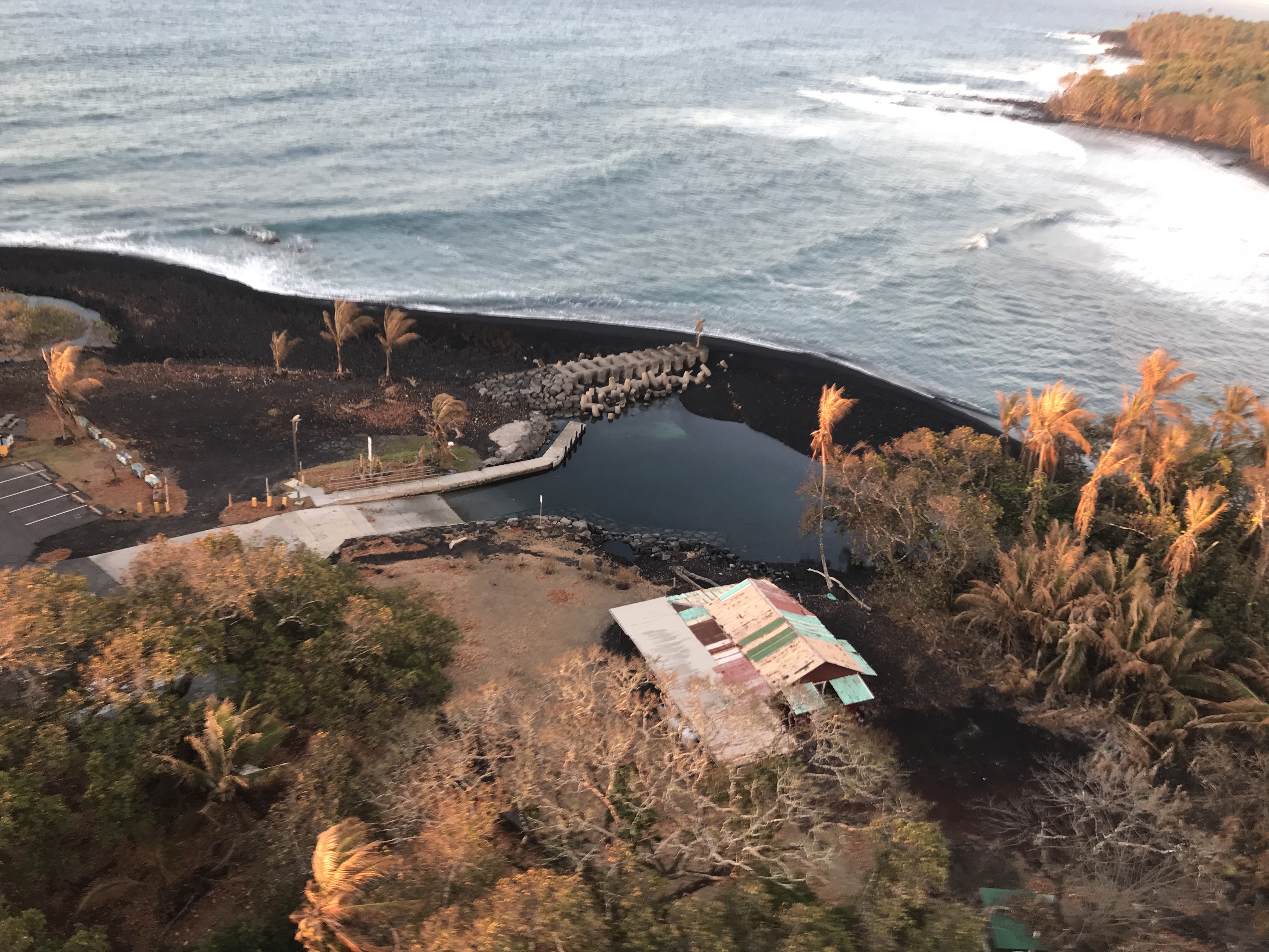
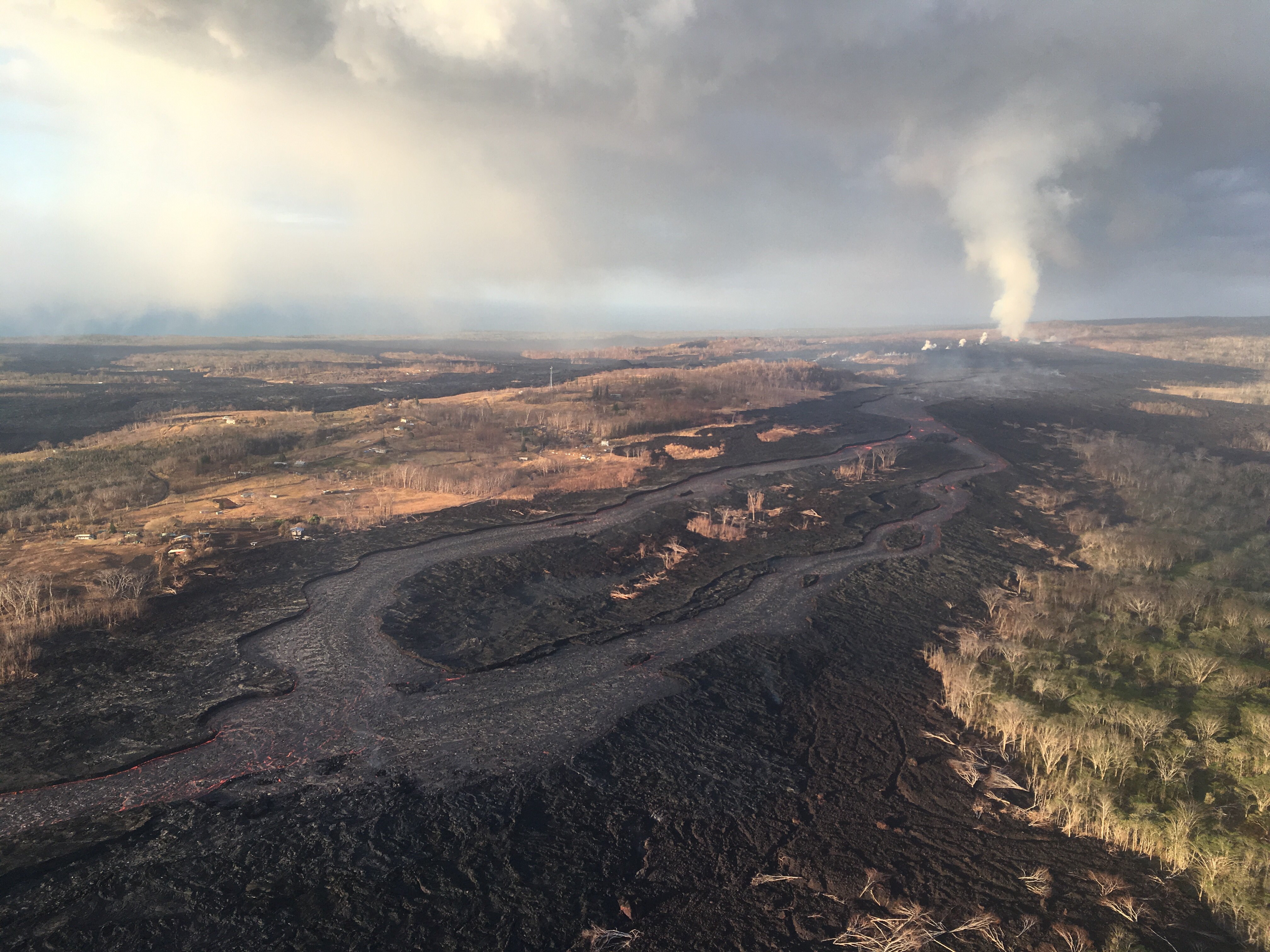
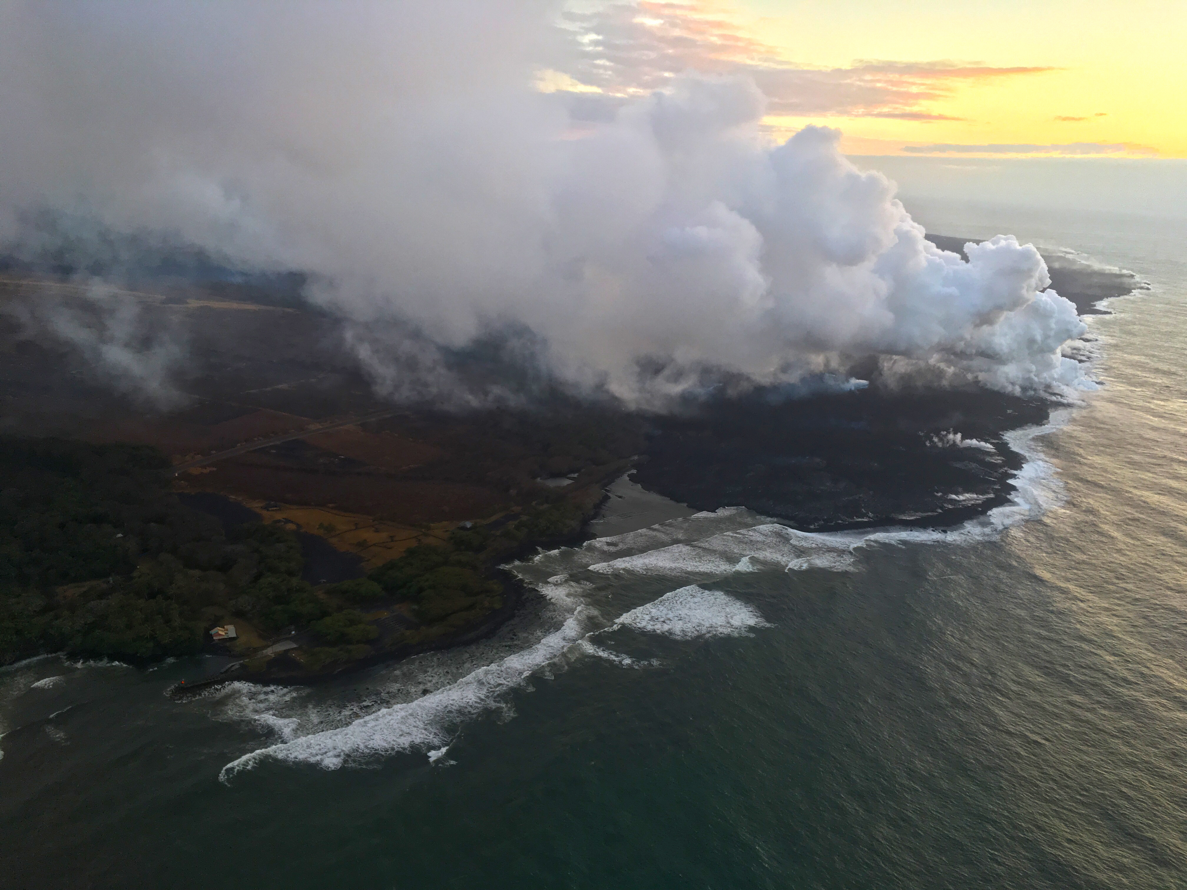
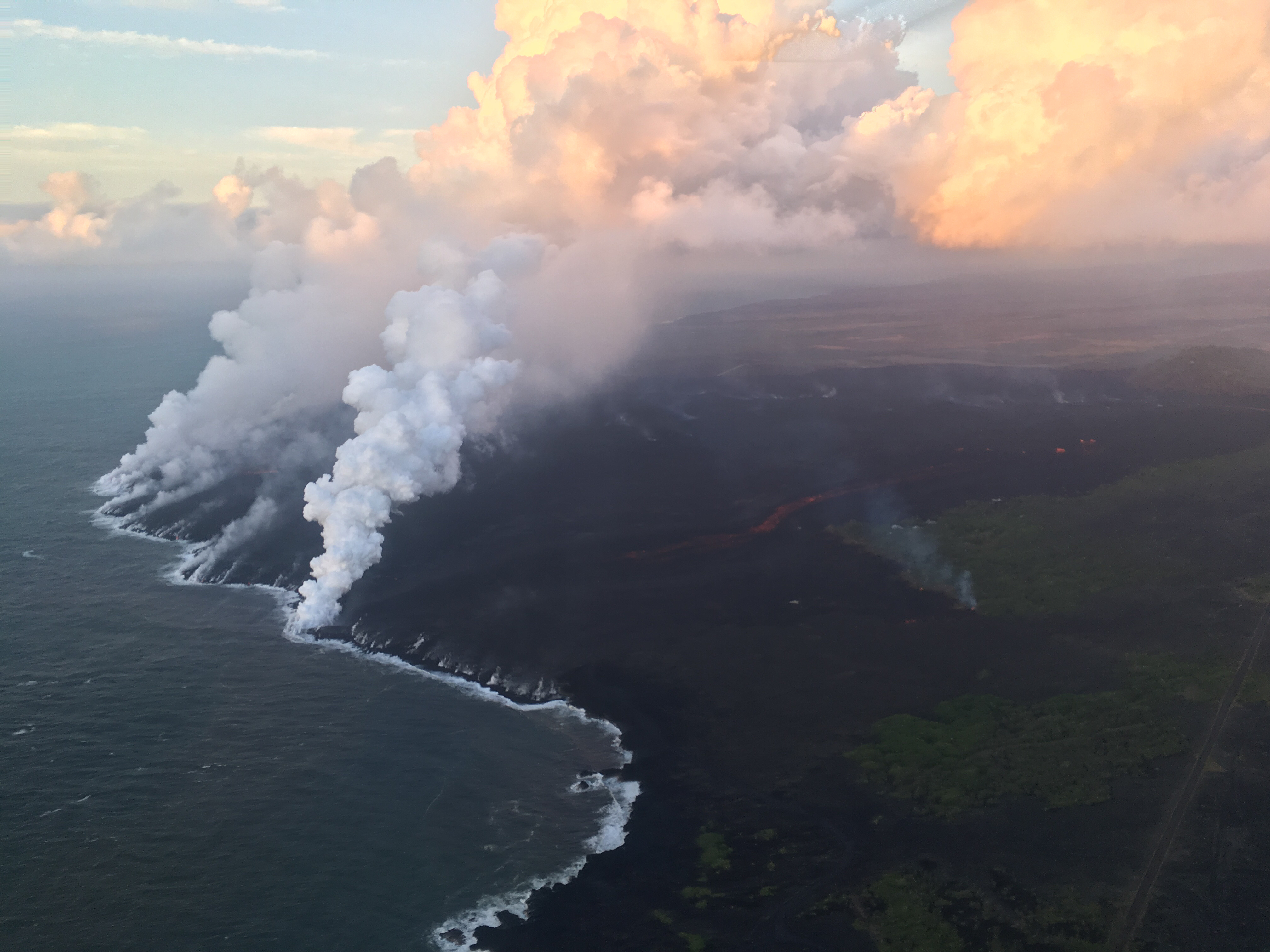
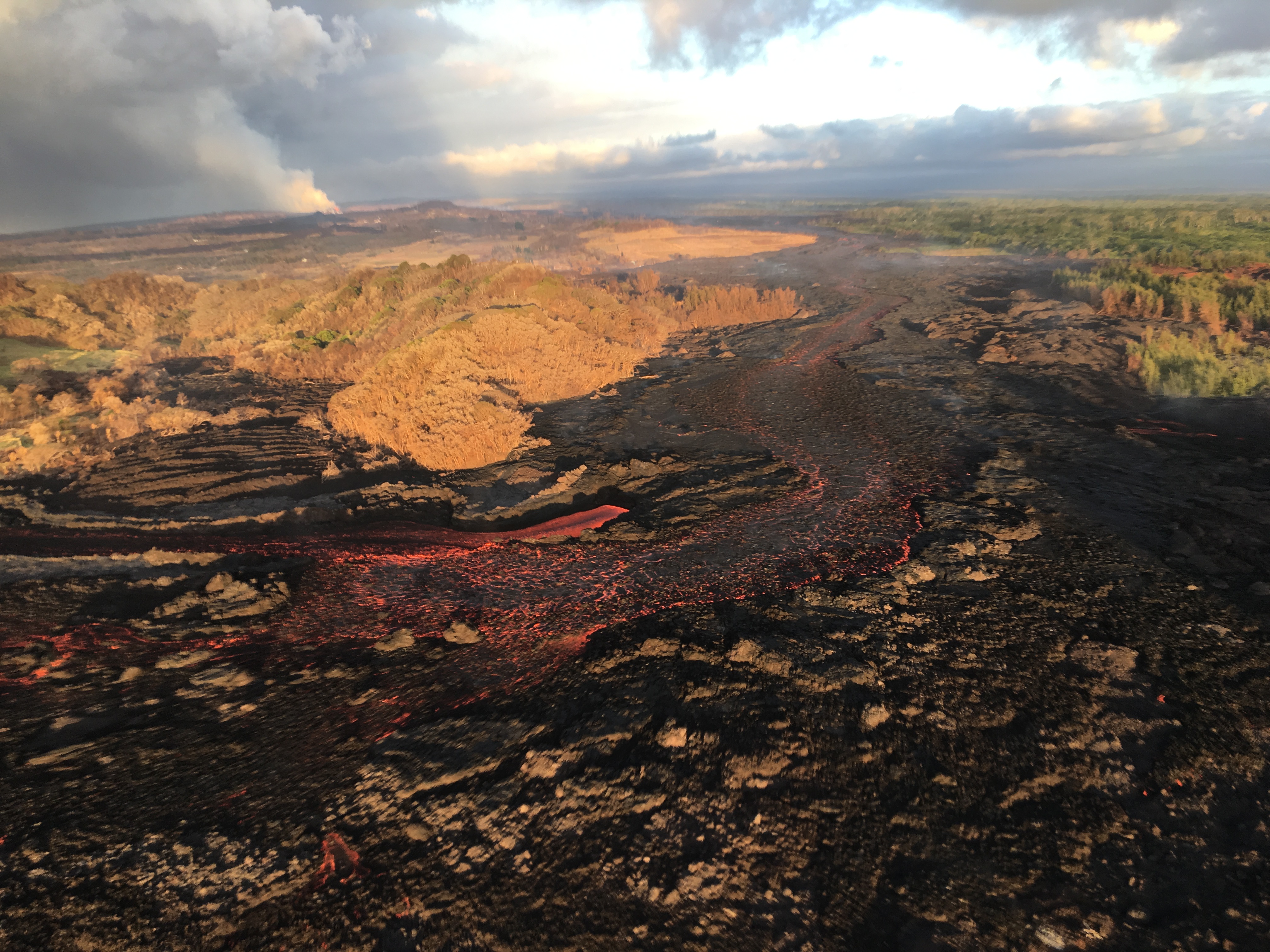
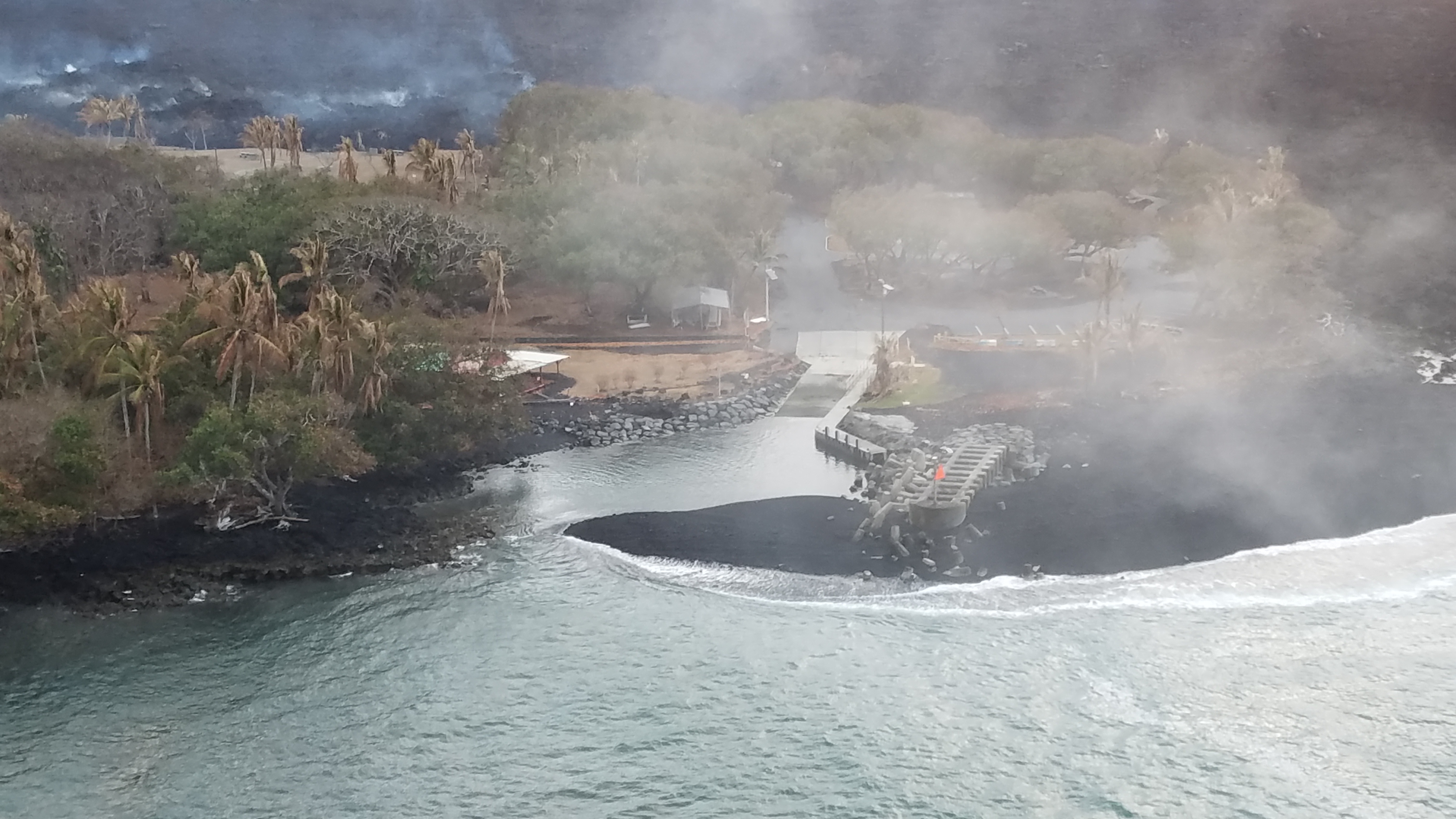
August 13, 2018. USGS: “Ocean entries were small and scattered this morning, but lava had made no significant advance toward Isaac Hale Beach Park. The Pohoiki boat ramp remains intact, but access from it to the open bay has been cut off by a sand bar that extends from the jetty to the shore. As molten lava streams into the ocean, it shatters into small glassy fragments, forming black sand that’s transported along the coast by longshore currents.” (Full-sized)
Eruption Summary: the Lull continues
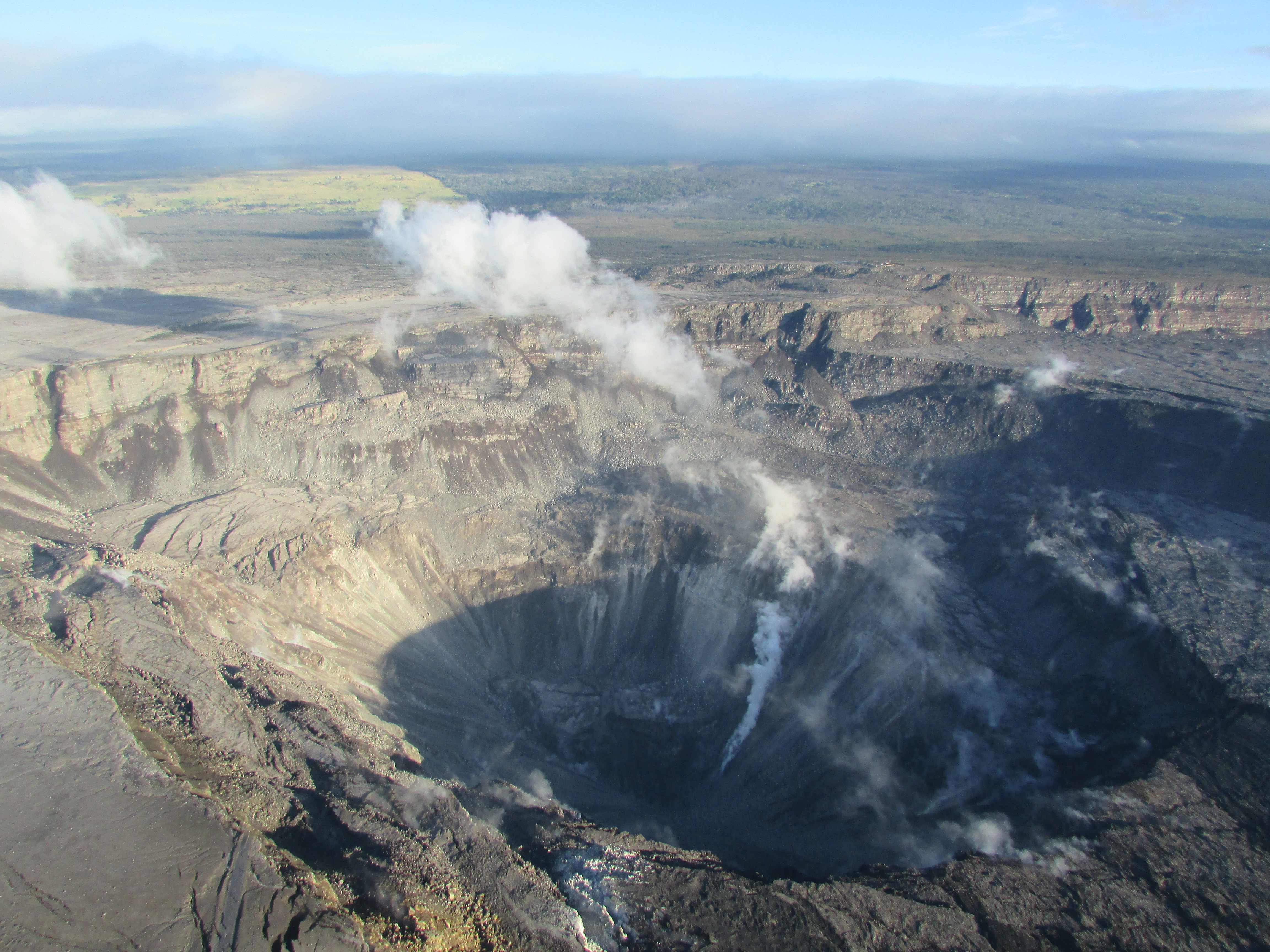
Fissure 8 is still emitting a gas plume, and lava circulates weakly within the cone. Residual lava is still draining into the ocean near Pohoiki. Gas emissions at the summit, Pu’u O’o, and even the Lower East Rift Zone are low.
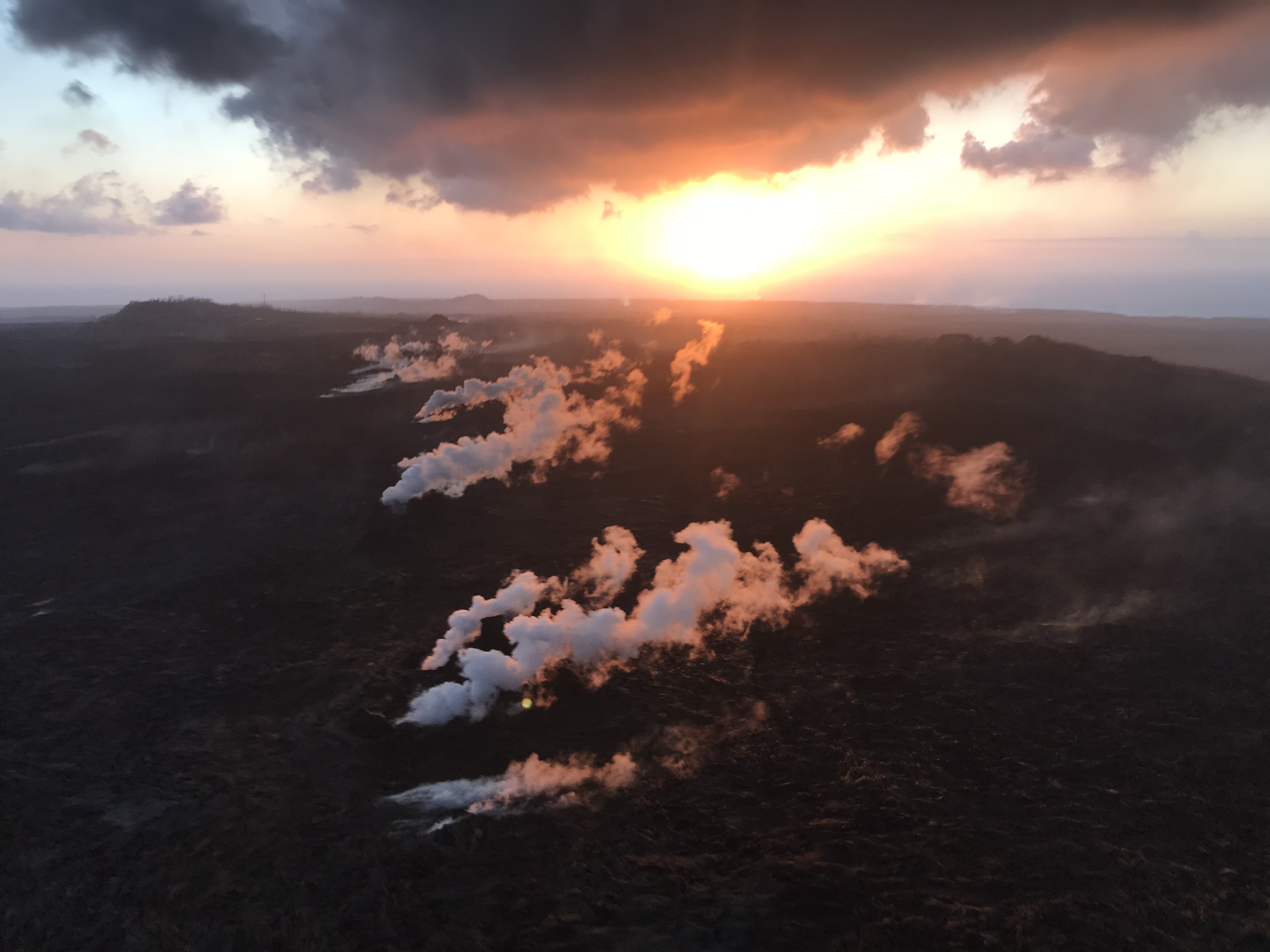
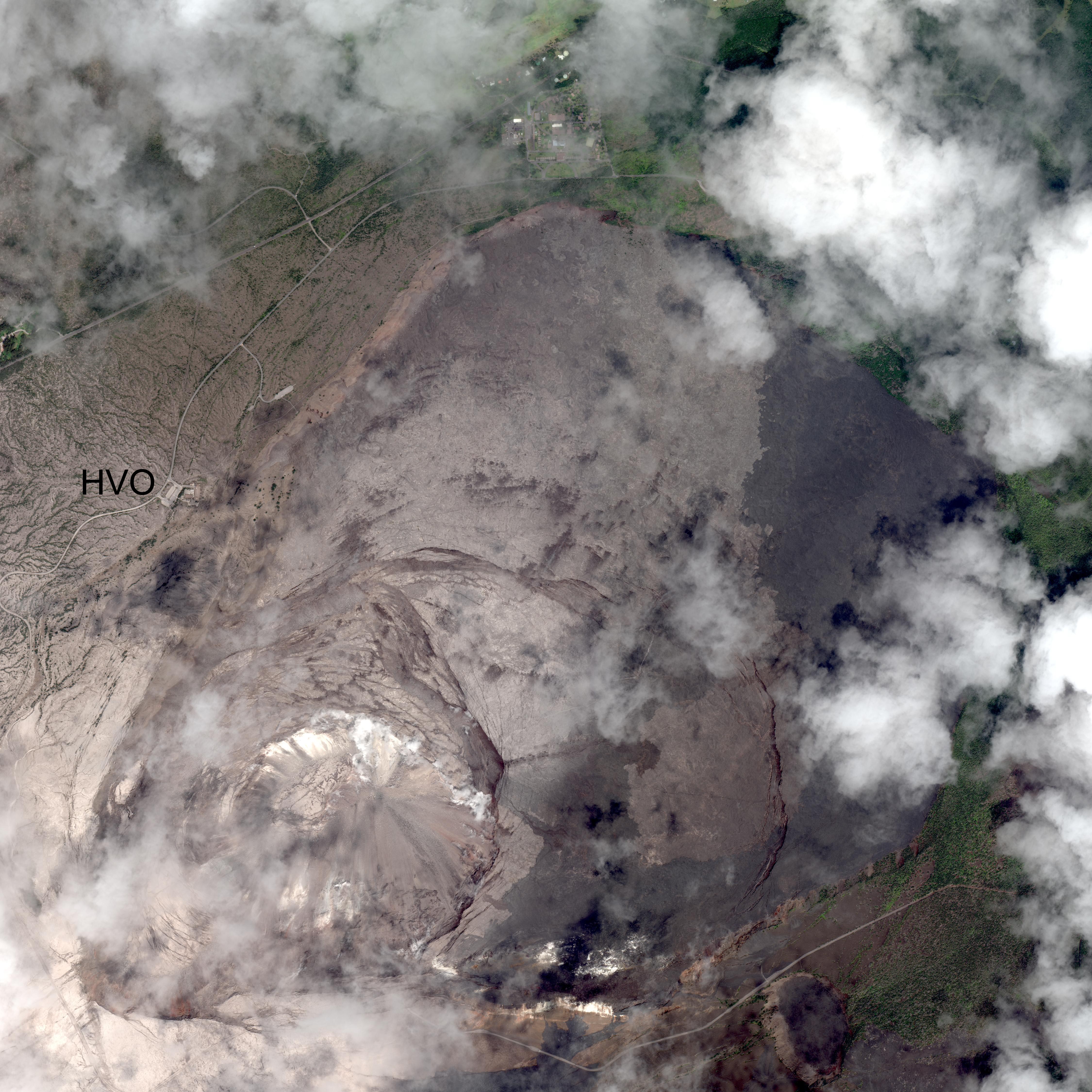
August 13, 2018. USGS: “During their overflight this morning, HVO scientists observed no new activity at any of the lower East Rift Zone fissures. At the fissure 8 vent, a “puddle” of sluggish lava remained in the cone. No other incandescent lava was seen along the fissure 8 channel, except at the ocean entry. Some other fissures were steaming, as seen here.” (Full-sized)
[This post is a followup to yesterday’s, where I reviewed HVO news, photos and videos from the past week. Here, I’m covering everything else: local news media outlets, images/videos from local photographers, and a week’s worth of good Q&A from HVO/USGS on social media.]
— University of Hawaii System (@UHawaiiNews) August 13, 2018
Timelapse of Kilauea Caldera Aug 2-9
August 12 LERZ Overflight
The latest from the @HotSeatHawaii gang. Mick Kalber’s August 12 video shows a few fingers of red lava dribbling out of the delta, and Pohoiki’s new sandbar which is currently blocking the boat ramp, but that can be moved. There’s a quick sweep over the weakly steaming fissures of the LERZ and a glimpse into Fissure 8’s cone, and then they tried to take a distant look at Kilauea’s summit:
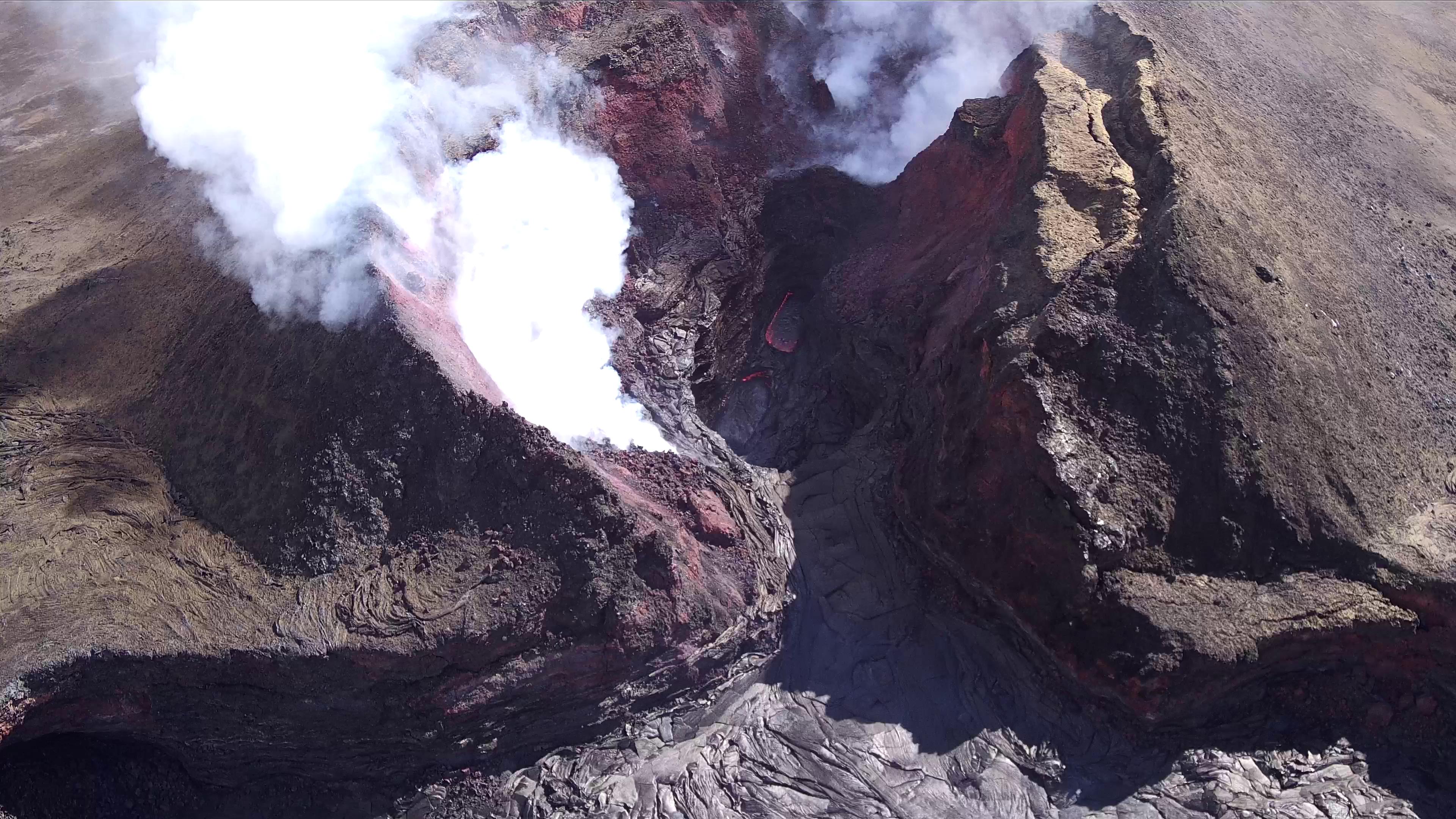
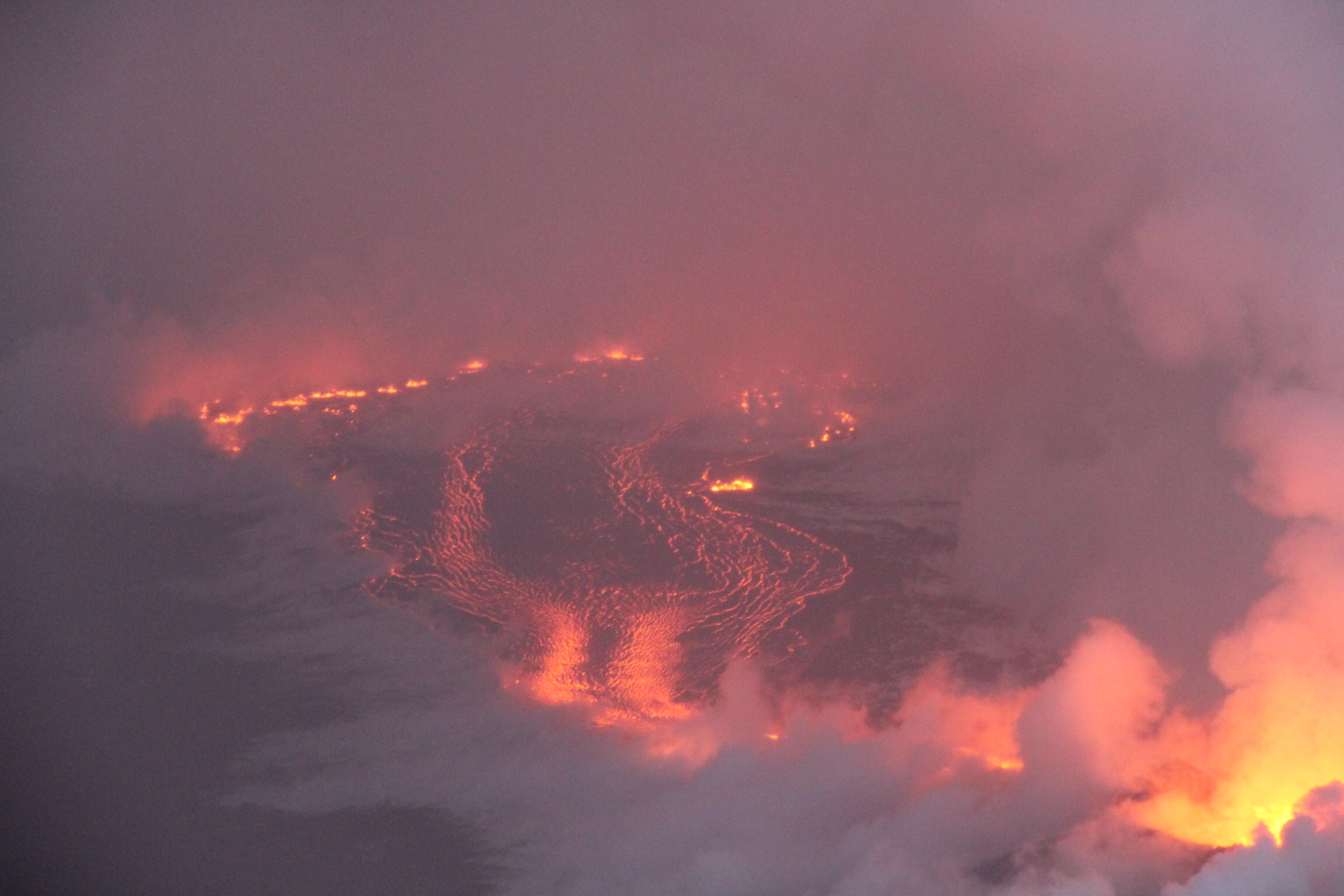
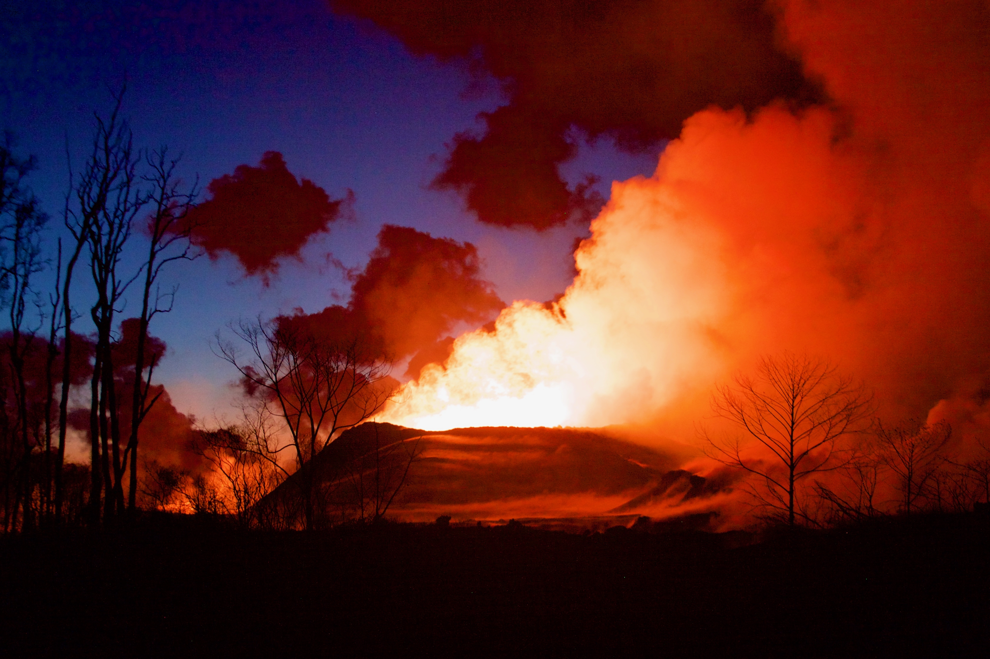
August 11, 2018. USGS: “The UAS team (Unmanned Aircraft Systems) flew a mission over fissure 8 to assess conditions within the cinder cone. As shown, fissure 8 contains two small ponds deep within its crater. One pond slowly circulates with an incandescent surface while the other pond is stagnant with a crusted top.” (Fuil-sized)
Weekly Eruption summary
So it’s finally arrived, the end (or at least intermission) of Fissure 8’s endless outpouring of lava from May 27 to August 4. The shutdown happened at the end of last week over a period of just 2-3 days.
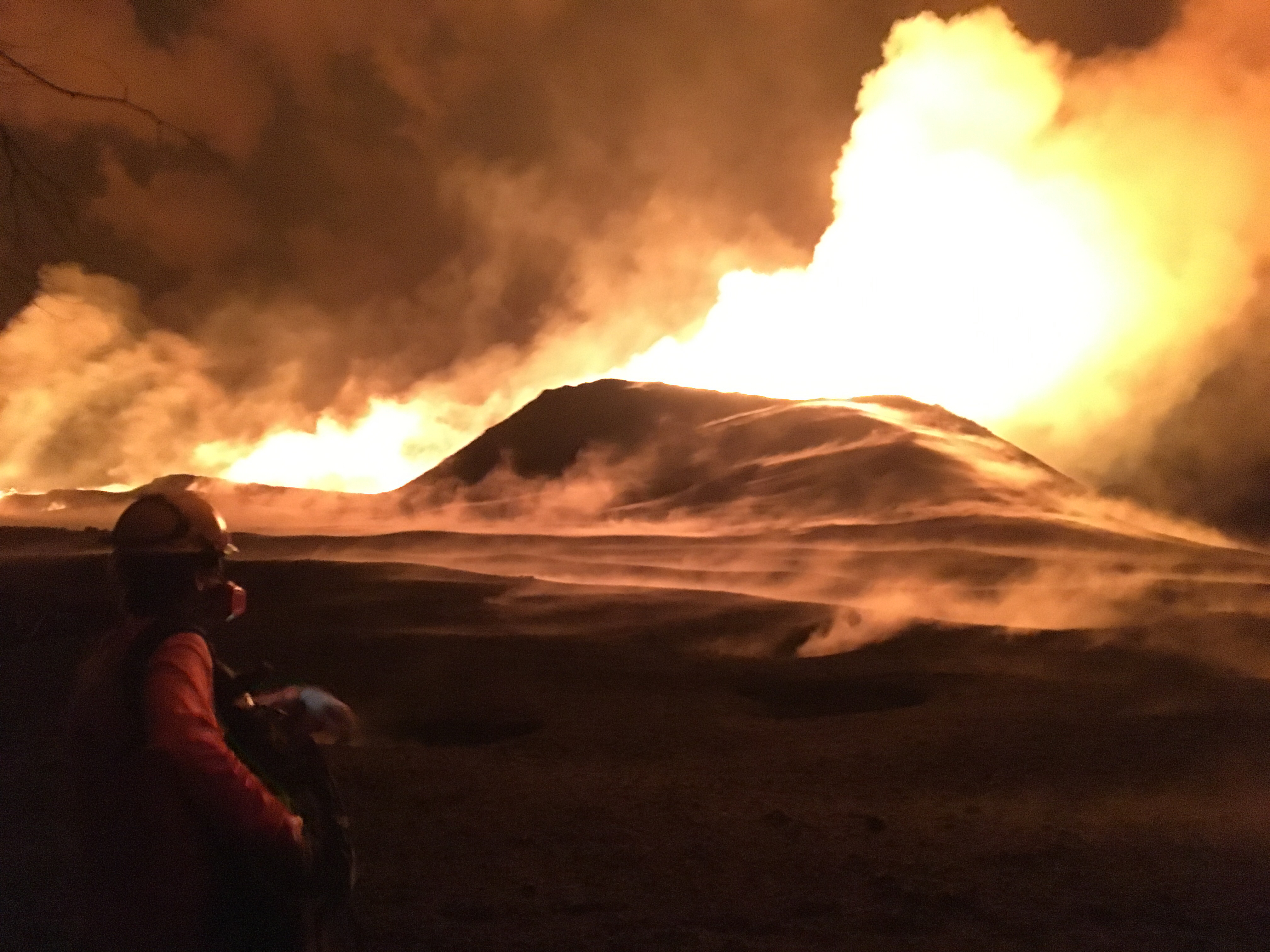
August 11, 2018. USGS: “The fissure 8 cinder cone is currently about 30 m (100 ft) tall with a very broad base. Sulfur dioxide (SO2) emissions are low, reflecting the diminished activity of the lava ponds in the cone.” (Full-sized)
Fissure 8 isn’t quite dead. There’s lava pooled deep down the cone, bubbling weakly. Residual lava is still draining out of the lava delta into the ocean, some of it quite near the now-famous Pohoiki Boat Ramp. But most of the surface channels have drained and solidified.
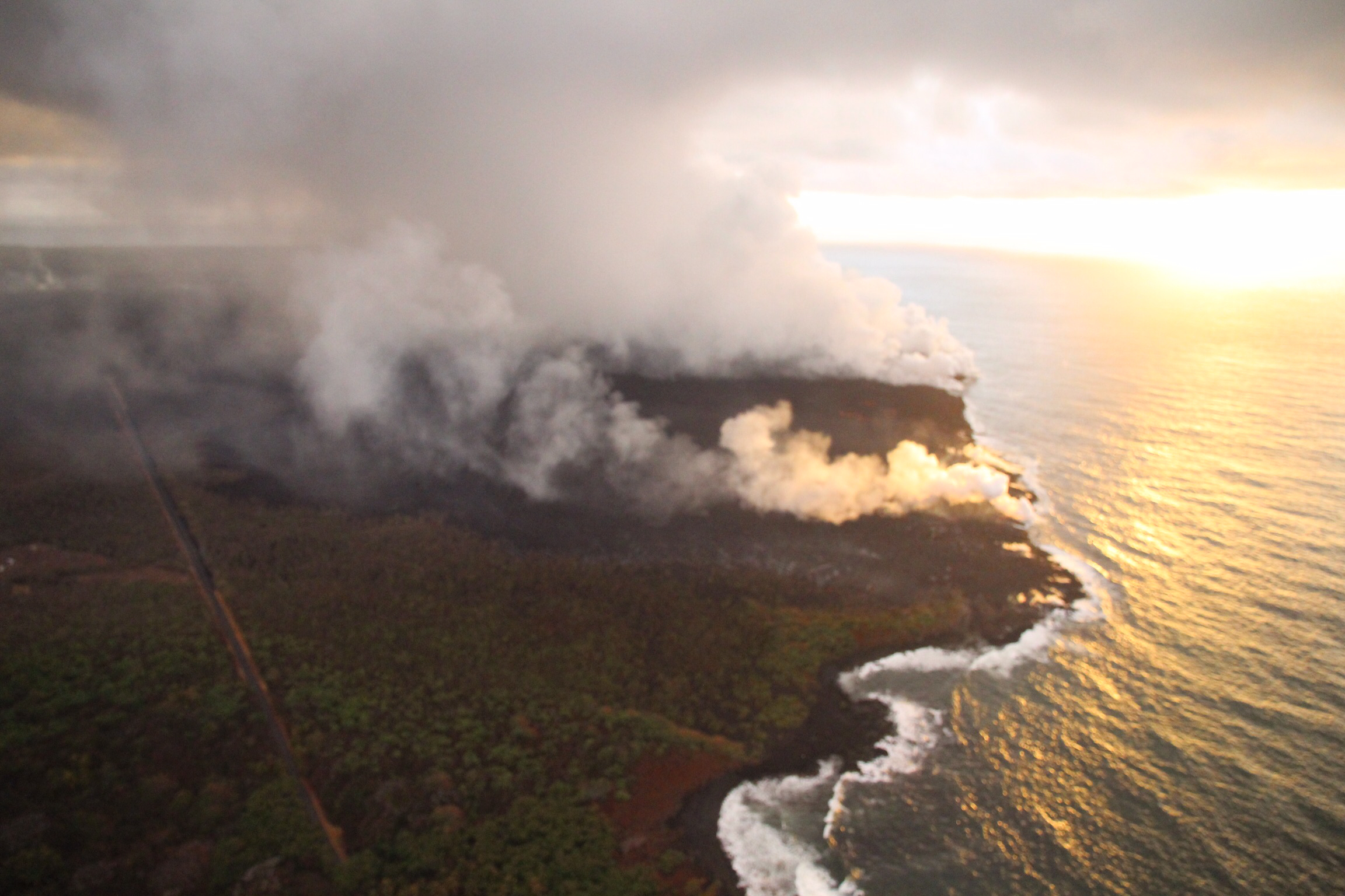
August 11, 2018. USGS: “Close view of the Pohoiki boat ramp during this morning’s overflight. The southern-most flow margin has not advanced significantly toward the Pohoiki boat ramp, but black sand and larger fragments from the entry areas have washed ashore to create a sand bar and beach at this site. Geologists observed several small lava streams trickling into the sea along the souther portion of the lava delta, producing weak laze plumes.” (Full-sized)
The volcano’s summit has settled, too. The caldera floor isn’t inflating or deflating, and the swarms of earthquakes and summit collapses have stopped.
So now the question becomes: how long do geologists, national park staff and residents wait before deciding it’s safe to start repairing the damage? Past Lower East Rift Zone eruptions have paused for days, even weeks. So scientists and officials continue to warn that this eruption could resume at any time.
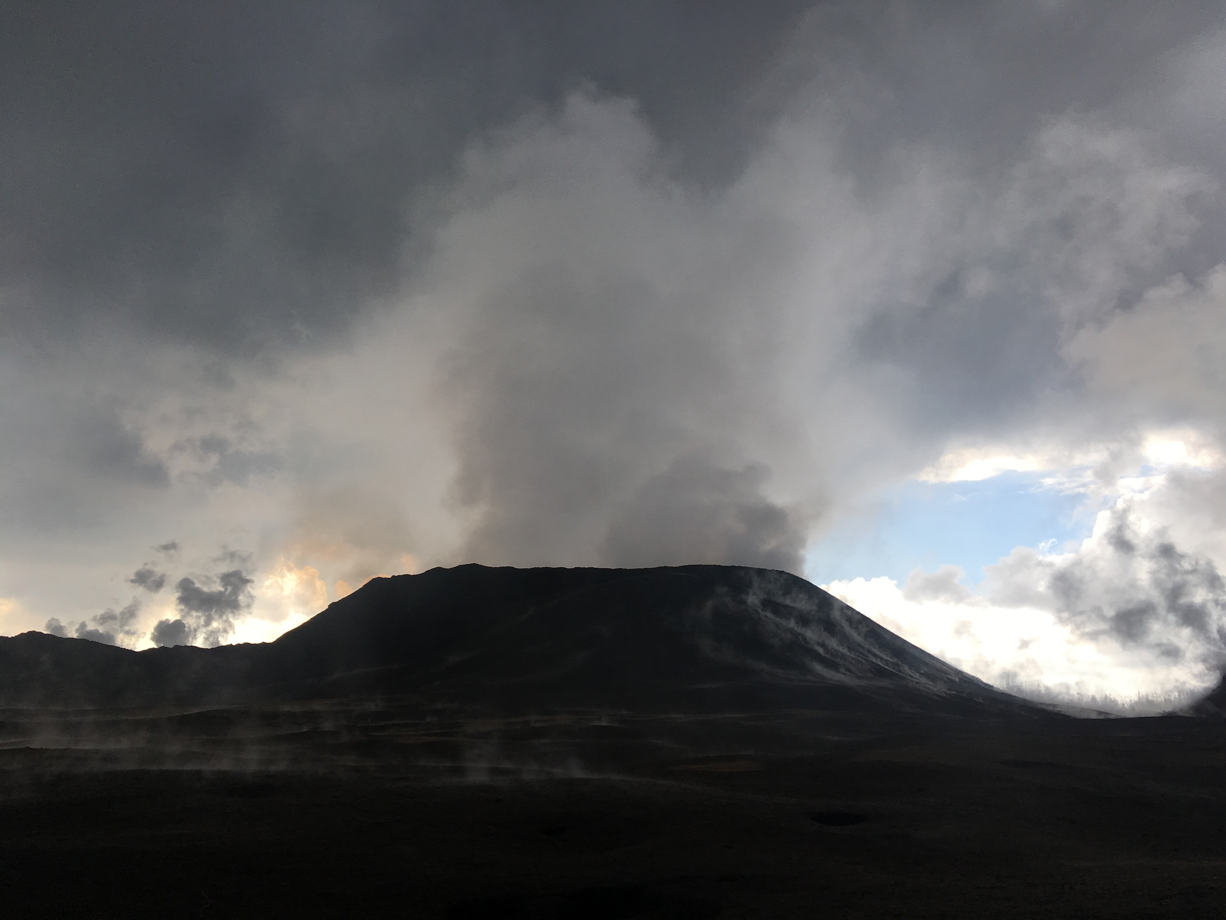
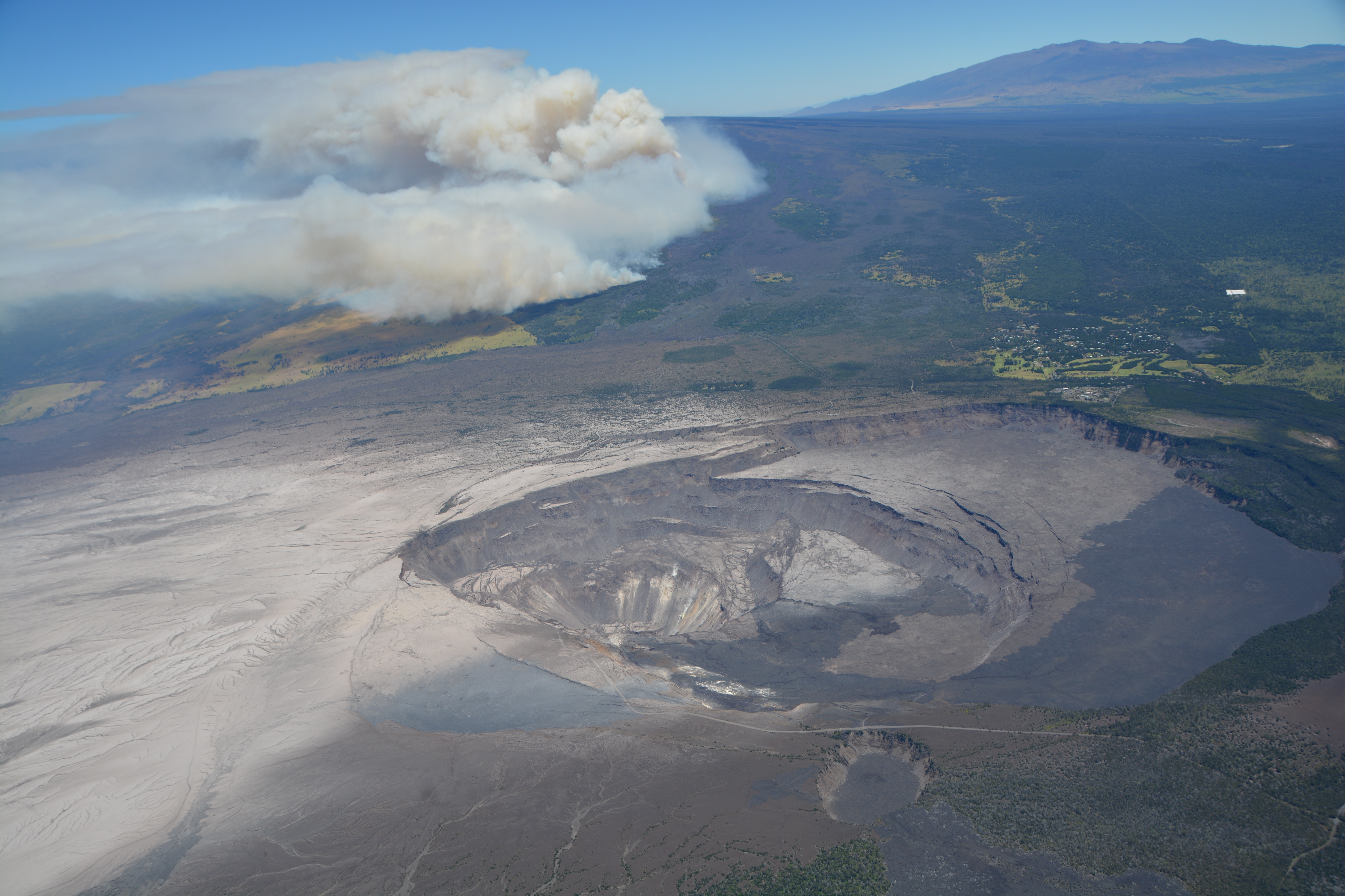
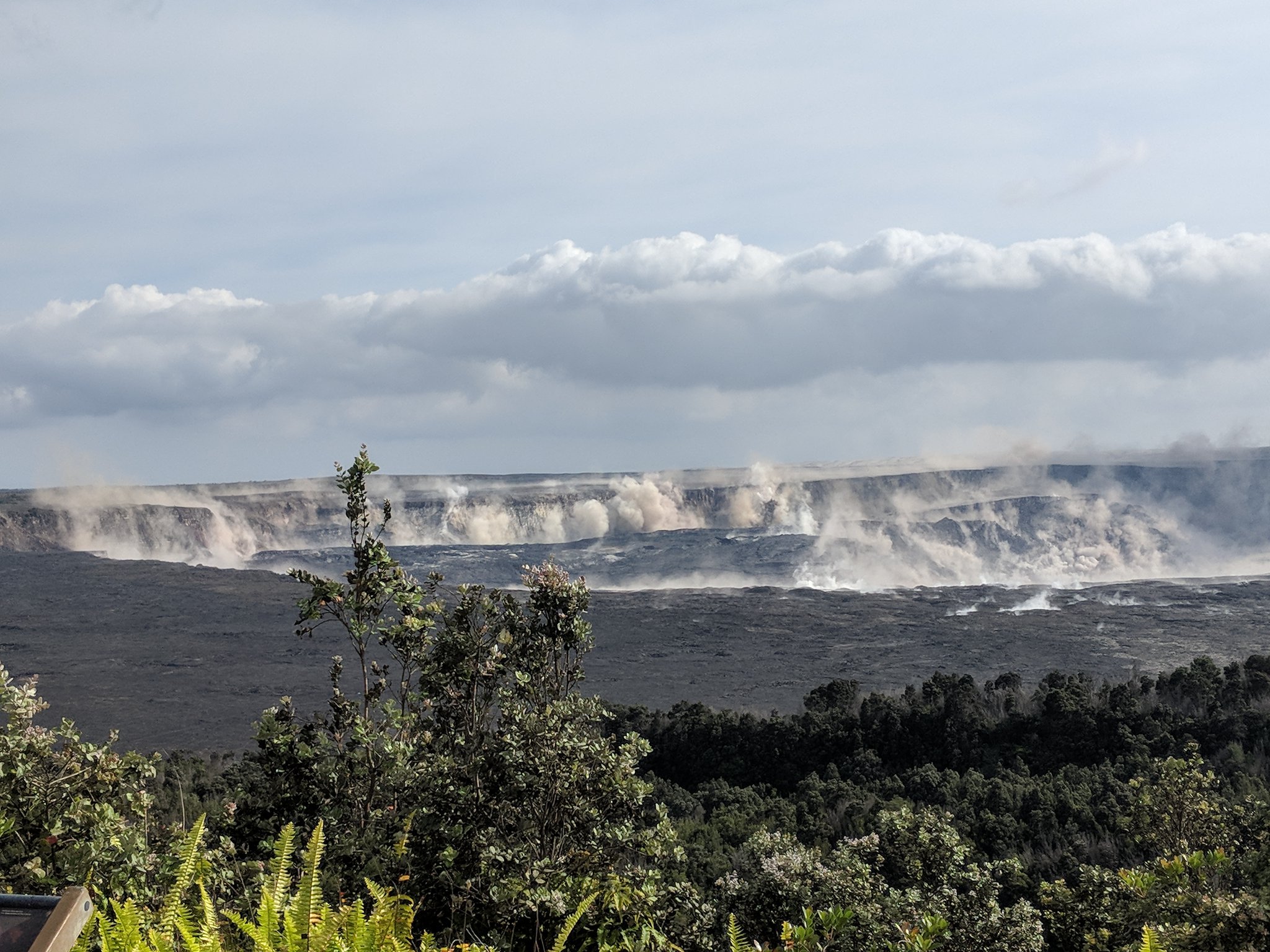
August 7, 2018. USGS: “Civil Air Patrol captured this image of Kīlauea’s summit yesterday (August 7, 2018), providing a stunning view of Halema‘uma‘u and the collapsed area within the caldera. Prevailing trade winds have blown much of the ash emitted during earlier explosions to the southwest (left), where thin layers of light-colored volcanic ash now blanket the landscape. Plumes of smoke rising from the flank of Mauna Loa were from a brush fire that continues burning today. Mauna Kea is visible on the upper right horizon; the crater visible at bottom center is Keanakāko‘i.” (Full-sized)
This week’s Volcano Watch column from Hawaiian Volcano Observatory, written August 9, addresses exactly that question:
Also, it looks like I missed an August 6 USGS news media briefing discussing the eruption’s apparent shutdown (full audio).
Now let’s look back at recent images and videos posted on HVO’s Photo & Video Chronology page, which only shows the 10 most recent posts— so these are visible there now, but won’t be in the future.
First of all, remembering past collapse events— with sound! Full-sized video posted here, or a faster-loading small version on Twitter:
Watch the ground shake and hear the roar of rockfall, in this video taken July 5, 2018: USGS cameras at Kīlauea Volcano's summit record a collapse event. https://t.co/VFDeSUjsFSpic.twitter.com/31JfblmDdC
August 2, 2018. USGS: “During this morning’s overflight, HVO geologists used a telephoto lens to capture this image of the fissure 8 cone. Activity within the vent was low, with small bubble bursts in the eastern part of the vent and low lava fountains on the western side. The fountains occasionally threw spatter onto the west rim of the cone (right).” (Full-sized)
Today’s summit collapse came at 11:55 am HST, energy equivalent of an M 5.4. Once again there was a cluster of high M3 foreshocks in the ten minutes or so beforehand, so that there was already some suspended dust from rockfalls.
Northeast Rim livestream cam was stuttering today, but still dramatic.
Also note that HVO’s Fissure 8 webcam was damaged by a brushfire Tuesday and ceased working. In fact, right now it’s stuck on the last photo it took.
While checking on the main webcams page, I caught a lovely time of the evening up at the summit. From the ones that are working:
Former Overlook Vent cam, now pointed at a sheer cliff above where it used to be. (Full-sized)HVO Panorama cam. All of these from about 6:40 pm HST. (Full-sized)Halema’uma’u wide angle webcam. (Full-sized)
And speaking of photos, I took a night off, and come back to find HVO posted a ton of good photos! Which I shall mirror here so they’re easier to find after they’ve “fallen off” that Photo & Chronology page.
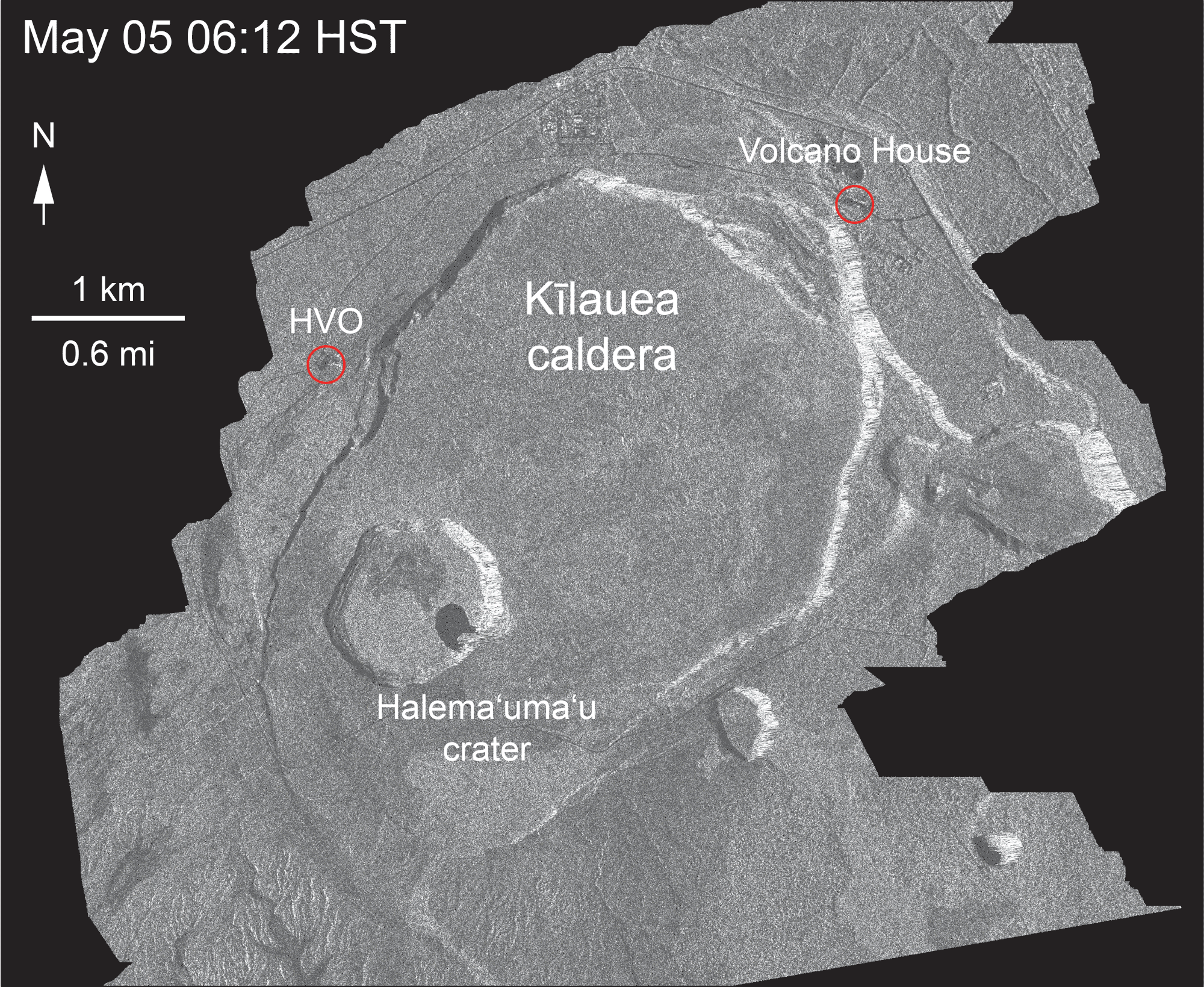
Most importantly, a new frame from the Cosmo-Skymed satellite radar animation:
Aug 1, 2018. USGS: “This animated GIF shows a sequence of radar amplitude images that were acquired by the Agenzia Spaziale Italiana CosmoSkyMed satellite system. The images illustrate changes to the caldera area of Kīlauea Volcano that occurred between May 5 and August 1 at about 6:00 a.m. HST.” (Full-sized
Accompanying text with this animation: “Over time, expansion of the summit eruptive vent within Halema‘uma‘u crater and the widening of Halema‘uma‘u itself are obvious. Starting in late May, the development of several cracks outside Halema‘uma‘u is clear, and inward slumping of a large portion of the western, southwestern, and northern crater rim begins. Much of this motion appears to be coincident with the small explosions from the summit that have taken place on a near daily basis since early June. The most recent radar scene, from August 1, shows continued motion along cracks over a broader area of the caldera floor, extending east of Halema‘uma‘u. We expect this slumping to continue as long as the collapse events and overall subsidence persist.”
Before and after: a new aerial photo of HVO on the rim of Kīlauea Caldera shows how greatly Halemaʻumaʻu has changed. For comparison, I found this 2008 photo in the USGS archives:
And here’s today’s overflight photo, from farther away.
July 29, 2018. USGS: “This aerial view of Kīlauea’s summit (taken early yesterday morning, looking south) shows some well-known features and some that are now more obvious as a result of ongoing collapse of Halema‘uma‘u and parts of the summit caldera floor. Crater Rim Drive (lower right) leads to the USGS Hawaiian Volcano Observatory and NPS Jaggar Museum (right, middle), perched on the caldera rim and overlooking the growing Halema‘uma‘u. Ground cracks, parallel to the crater rim, are visible on the north side of Halema‘uma‘u (left side of image—also see our July 28 photo). South Sulphur Bank stands out as the light-colored area on the opposite crater wall (see our July 22 photo for a closer view of this feature).” (Full-sized)
The scientists of HVO had to abandon their 100-year-old observatory on the caldera rim mid-May. During the summer session, the University of Hilo was able to provide them with plenty of space for a temporary HQ. With fall term around the corner, HVO has leased part of the U.S. Customs Building in Hilo while they seek a more permanent solution. Because if and when the summit stabilizes, the old observatory will have to be rebuilt, or at the very least, will require massive repairs.
Speaking of the summit, today’s collapse event was at 12:10 pm, energy equivalent of M5.4. I captured the rockfalls 3-4 minutes before, as well as the actual summit collapse:
The clock on the Northeast Caldera Rim livestream is about a minute fast, but it’s so tiny you can’t see it anyway. The actual collapse starts about 1:30 into this video:
No changes on the Lower East Rift Zone eruption today.
Here’s the other HVO images for July 29 (as usual, I’m mirroring them because the HVO “Photo and Video Chronology” page only shows the 20 most recent entries, making images older than two weeks somewhat inaccessible.)
July 28, 2018. USGS: “Aerial view of the summit crater from this morning’s overflight. Zoom in to see HVO and the Park’s Jaggar Museum on the caldera rim (right side of photo).” (Full-sized)
Note the light green mostly-treeless area in background at left, and then zoom in to find museum & observatory on rim at right. Then compare with:
April 13, 2018
BEFORE the big event: Kilauea caldera, April 13, 2018. USGS: “The museum and HVO are perched on the caldera rim (middle right), with the slopes of Mauna Loa visible in the background.” (Full-sized)
Today’s Eruption Summary
Summit collapse event at 2:37 am HST, July 28, 2018. Energy release equivalent to M5.4. Minor overflows on Fissure 8’s channel reported a few hours afterwards. At the coast, the SW edge of the flow remains stalled 175 m from Pohoiki boat ramp, with ocean entry a few hundred meters to its east.
Road crews are monitoring cracks on Highway 130 after increased gas emissions were detected there.
Also, notwithstanding longer intervals between recent summit collapses and a few days where the lava channel seemed lower, HVO doesn’t see any strong indications the eruption is weakening:
We can't say for sure, but we don't think so. We've had long intervals between Type A events in the past, and the channel today appears to be as active as it has been in past days, with overflows on existing lava in some places.
Remember how OpenTopography.org recently posted LIDAR surveys of Kilauea from 2009, June and July 2018?
Well, volcanology PhD student Fumihiko Ikegami (@fikgm on Twitter) has been creating great 3D renders using this data. Click on images below for large-size views of each render.
You can turn, zoom, and view this 3D model from any angle:
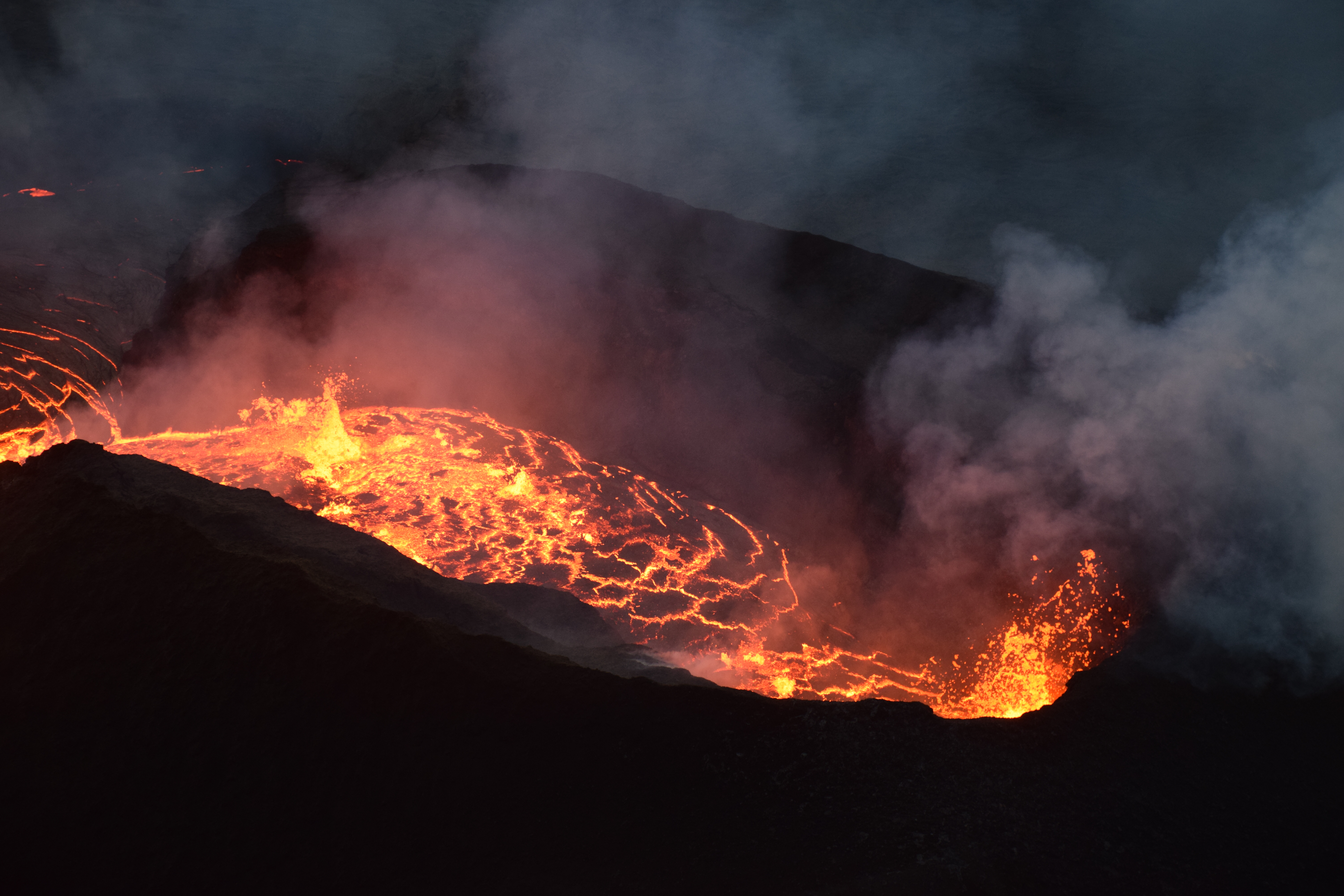
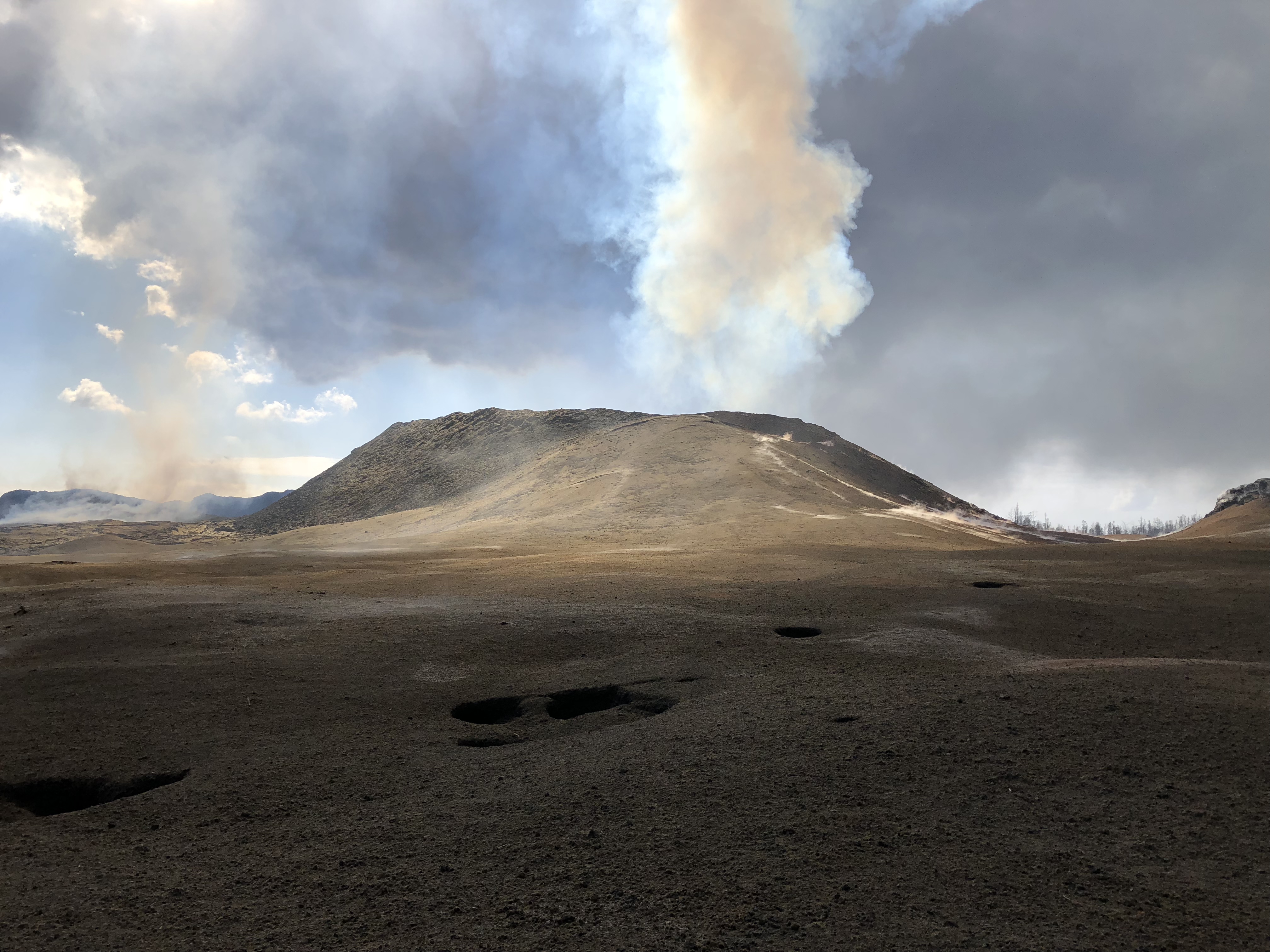
July 19, 2018. USGS: “Volcanic gases rising from the fissure 8 vent and lava channel feed a pyrocumulonimbus cloud above the tephra cone. Small pits in the tephra deposit (foreground) form when the lava fragments collapse into cracks and void spaces below the surface.” (Full-sized)
Today’s Eruption Summary
As per usual. Fissure 8 continues to feed the lava channel down to the ocean, where the southern margin of the flow was 500 m from Isaac Hale Park this morning. Lava levels in the channel this morning were low, with the previous collapse event coming at 1:28 am the day before.
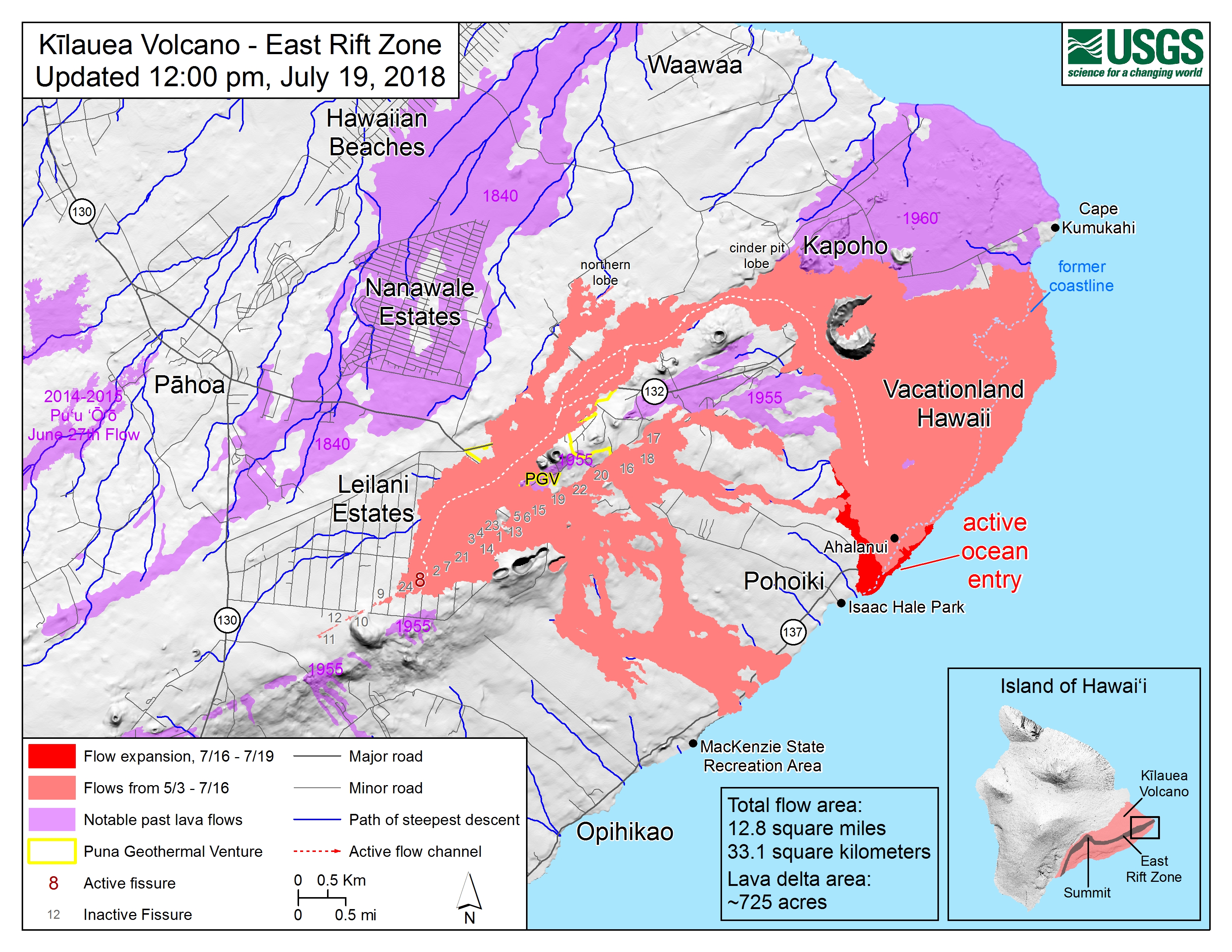
July 19, 2018. USGS: “An aerial view looking south, with the fissure 8 lava channel on the west side of Kapoho Crater, visible at left. As it nears the ocean, the channelized lava transitions to a broad ‘a‘ā flow that spreads laterally and toward the coast. The ocean entry plume is barely visible in the far distance (top).” (Full-sized)
Today’s summit collapse event occurred at 4:33 pm.
July 19, 2018. Collapse event tweeted by USGS: “Hereʻs a photograph from the 4:33PM #TypeA collapse event from #Kilauea summit. Rockfalls occurred from near-vertical cliffs around the #caldera and #Halemaumau.” (Full-sized)
WHT: “Fire sparked during RIMPAC exercises consumes 2,000 acres” – As I suspected. Those fires on the saddle between Mauna Loa and Mauna Kea which prompted the usual “Is Mauna Loa erupting?” questions were started by military training exercises.
Mick Kalber Overflights
Mick posted yesterday’s June 18 overflight (good views, including that lava flow moving over a still-active but slower flow) and notes as well as today’s:
Q: [Is Cape Kumakahi still the easternmost point of the island?] USGS: The area off Kapoho has a paltry supply of lava now – unless significant lava returns, the eastward advancement may cease.
Q: [Has there been any change in temperature of lava, now that it’s crusting over and/or not a fluid channel all the way to the ocean? Any sign eruption is ending?] USGS: No, the temperature remains the same. Other factors are probably responsible for the crusting – blockages, flow velocity, precipitation, etc. Sometimes the channels remain fluid, and sometimes the surface can crust over – but that doesn’t mean there isn’t lava moving beneath the crust… No, no signs that the eruption is ending yet.
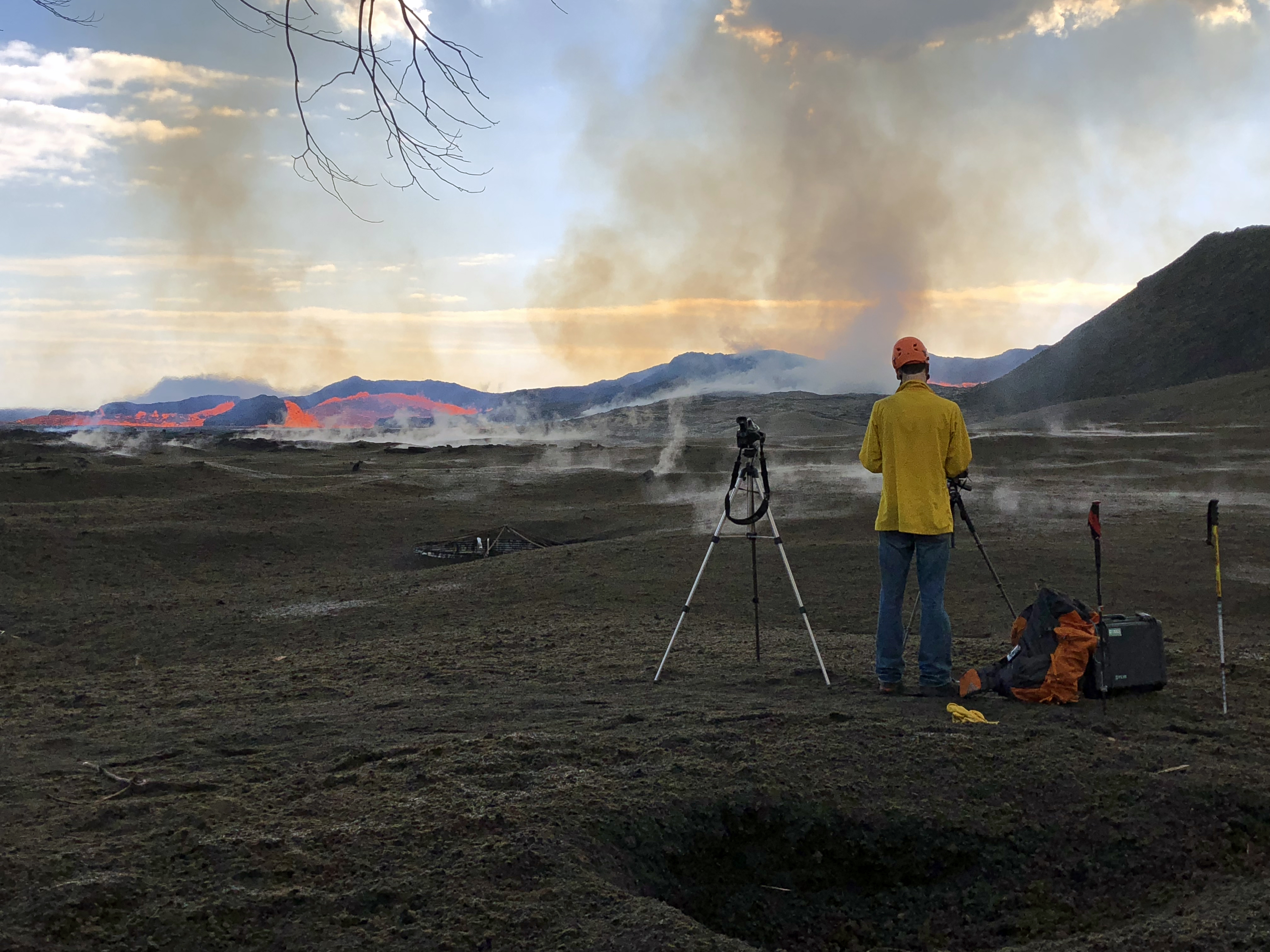
July 19, 2018. USGS: “his HVO geologist is standing on tephra (airborne lava fragments, such as Pele’s hair) that was erupted from and deposited downwind of the fissure 8 vent. He was there to observe the vent activity and to capture both thermal and video imagery of the pulsations occurring in the near-vent channel. The frame of a water catchment tank cover can be seen in the tephra deposit to the left of the geologist’s camera and tripod (center).” (Full-sized)
Q: [Someone asking about webcams and livestreams] USGS: We weren’t able to adjust the bandwidth on the cam from HVO, but we did add the stream from the northeast caldera, which uses a different (and still challenged) connection.
July 19, 2018. USGS: “Numerous rockfalls have occurred within Halema‘uma‘u and along Kīlauea’s summit caldera walls today, stirring up existing ash deposits and rock dust, and creating sounds that, at times, could be heard from the northeast rim of the caldera.” (Full-sized)
Q: [Cinder cone is 120 feet now? Was 180; has it collapsed?] USGS: Some settling has occurred, and some of the more precarious bits have probably fallen in or down the slopes. [Same basic question, different day] USGS: Yes it has succumbed to thermal erosion, collapse, and settling. There have been no sustained fountains depositing material on its outer slopes for several weeks, so there has been no additional accumulation of tephra.
Vladimir Vysotsky on FB: USGS Volcanoes: you keep characterizing this as a “perched channel”. I wonder if that is how lava tubes form – a channel builds the foundation and walls around itself, then crusts over while still flowing inside, and eventually forms a tube when the lava finally drains. Is that a correct assumption?
USGS Volcanoes: That is a very accurate description of lava tube formation! ][…] Hereʻs a video from Hawai’i Volcanoes National Park describing what you d[id] with video footage to accompany for visual reference. https://www.nps.gov/media/video/view.htm...
Q: [Is Fissure 8 how Diamond Head formed?] USGS: – Diamond Head is a tuff cone that erupted through water. It is also considered “rejuvenation stage” volcanism. The eruption that formed it occurred after the Koʻolau Volcano (from where it erupted) had been dormant for about 2 million years! http://volcano.oregonstate.edu/post-erosional-rejuvenation
July 19, 2018. USGS: ” An aerial view looking to the west, near the braided section of the fissure 8 lava channel. During this morning’s overflight, the channelized lava was at a lower level than usual, but was still being fed by vigorous outflow from the vent.” (Full-sized)
Q: [How long will this go? How will it end? Does a lava flow normally start slowing down and then stop?] USGS: This could go on for any number of days, honestly. Typically these things don’t just turn off and stay turned off. We expect that activity in Fissure 8 will wane, then stop and start again (perhaps at other fissures). However, the eruption won’t stop all together until the pressure driving the magma out of the ground has been relieved.
Q: [How deep is lava channel?] USGS: We have tried to calculate depths based upon lava-flow observations within the channel and known depths of dormant channels on other locations in the Hawaiian islands. The channel is meters in depth, but likely not more than 10. Depth varies throughout its length as well.
[In discussion that Fissure 8 is not a volcano— it’s a vent on Kilauea’s flank just like Puʻu ʻŌʻō was, with magma being piped down from Kīlauea’s magma storage system— someone brought up Lō‘ihi, which IS a new volcano (or seamount) off SE coast of Big Island, still underwater.]
July 19, 2018. USGS: “As of this morning, the southern margin of the fissure 8 ocean entry was about 500 m (0.3 mi) from the boat ramp at Isaac Hale Park.” (Full-sized)
Q: [Is the summit caldera sitting on the magma chamber?] USGS: The subsidence area within the caldera essentially overlies the area of the shallow magma storage region that fed the lava lake in Halemaʻumaʻu. So, yes. Q: [Could the floor collapse into the chamber? What would happen then?] USGS: Technically speaking, the floor, and everything that was between it and the top of the chamber, is collapsing into it. Youʻre seeing the outcome – pressure drops and collapse events that manifest as M5.3 earthquakes.
Things too obscure to bug USGS about: why is it “littoral” when the Latin word for seashore has only one “t”? [Checks etymology: ah, yes, it’s a Medieval Latin spelling.)
July 9, 2018. USGS: “Lava entering the ocean as seen through steam and rain early this morning.” (Full-sized)
Today’s Eruption Summary
Wild weather, overflows and significant channel reorganization have made the Lower East Rift Zone more interesting today than those living near Bryson’s cinder pit would like.
July 9, 2018. USGS: “This photograph taken during this morning’s overflight shows heavy, localized rain at fissure 8 in Leilani Estates.” (Full-sized)
Sunrise overflights by the USGS and @hotseathawaii spotted a torrential downpour centered directly over the upper lava flow (above). A rain gauge in Leilani Estates measured 9.22″ rainfall at 7am for the past 24 hours; another just a little farther away measured 6″ over the same span. All that updraft, convection and condensation even produced a modest… lavaspout…? captured on video (strong language warning):
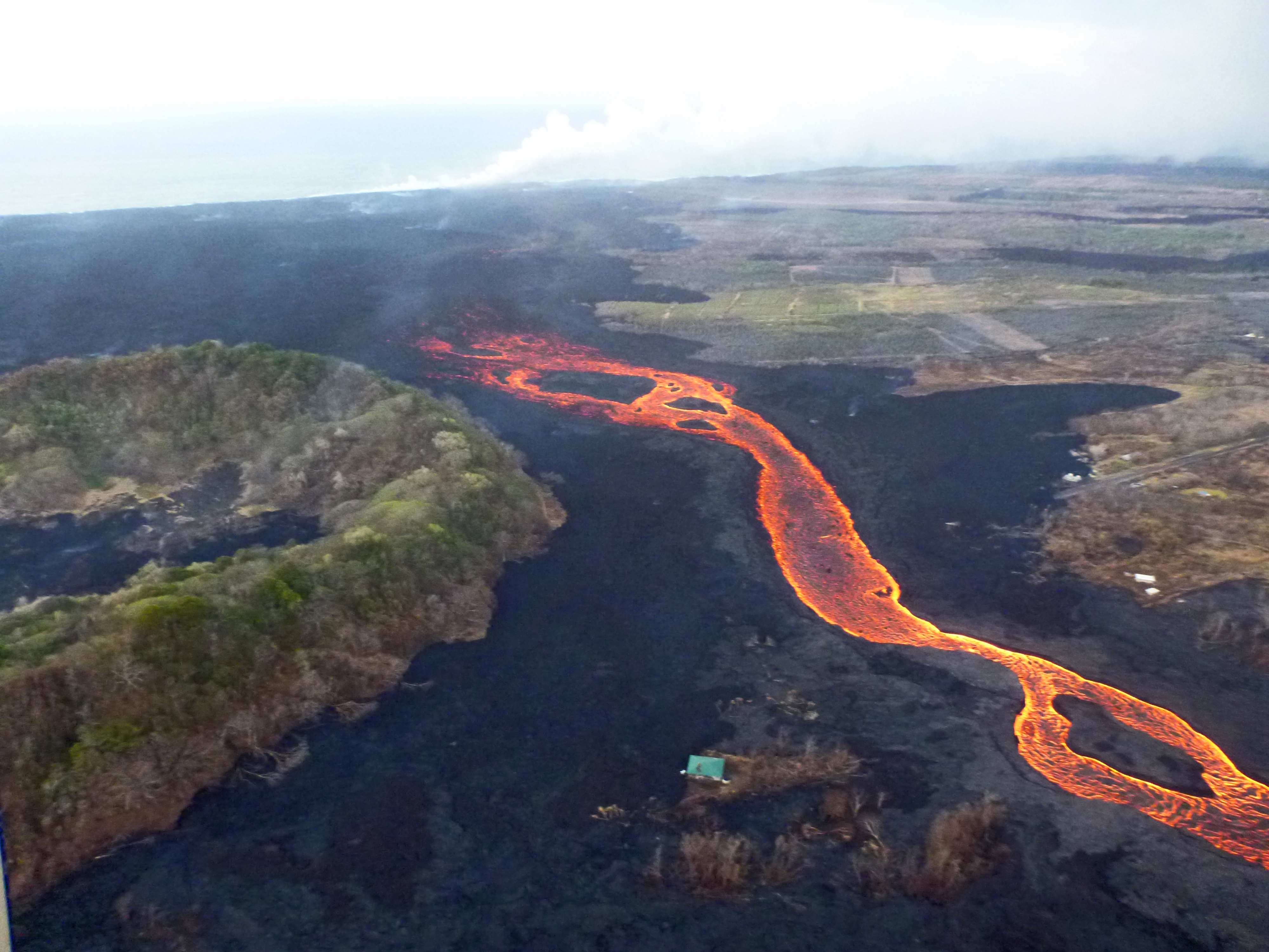
The Kapoho end of the LERZ eruption was even more chaotic. Over the weekend, several non-USGS sources had reported that lava was starting to shift back to the south after passing Kapoho Crater, forming a slow-moving flow headed for Ahalanui Ponds (and sparing 3 of the 4 remaining Kapoho Beach Lots houses). This morning, HVO status updates confirmed the change: “The main lava channel has reorganized and is nearly continuous to the ocean on the south side of the flow, expanding the south margin by several hundred meters.” Also, while the ocean entry was still a very broad 2.5 mile front at sunrise, it’s started to coalesce a bit and shift towards the south:
July 9, 2018 (later in the morning; can’t be afternoon because of sun position). USGS: “Sourthern end of the active fissure 8 flow margin north of the Analannui Park [sic], known as the warm ponds. The flow margin is estimated to be about 500 m (0.3 mi) from the park.” (Full-sized)However, blockages in the braided section of the lava river caused further havoc later in the day. HVO’s afternoon status update reported that, “Early this afternoon, observers reported multiple overflows occurring along both sides of the main lava channel, in an area extending from near the ‘Y’ intersection at Pohoiki Road eastwards to an area just west of Kapoho Crater. Overflows on the upper part of the channel did not extend beyond areas previously covered in lava. Overflows further down the channel have reached beyond the flow field, including one flow lobe that is moving northeast from the main channel towards Cinder Rd.”
July 9, 2018. USGS: “The lower section of the fissure 8 lava channel appears to be almost completely crusted over, and the lava level in the channel was lower during this morning’s overflight.” (Full-sized)
[HVO afternoon status update cont’d] “Based on information from ground observers and morning and afternoon overflights, the lower part of the main lava channel has undergone significant reorganization. In particular, the channel that had been open near Four Corners is now mostly crusted over, and plumes from ocean entry are significantly reduced. It is likely this is due to a blockage that formed in the early morning in the main channel upstream of Kapoho Crater. Flow volumes coming out of Fissure 8 remain significant, and it is possible that changes in flow channels will continue to occur in the coming days.”
Meanwhile, up at the summit, it’s business as usual. This morning’s collapse event occurred at 9:20am, registering once again as 5.3:
USGS posted yesterday’s thermal map first thing this morning, plus a 2pm map today showing these changes:
The Lower East Rift Zone eruption continues pretty much as usual: Fissure 8 feeding a lava river with occasional short-lived overflows. The main lava channel no longer reaches the ocean, but crusts over a half mile from shore and dives into the lava delta, oozing out at multiple points on the northern side. One especially large “ooze-out” makes a short flow on the north side of the flow field near the last few Kapoho Beach Lot Houses, a few of which are hanging on. Fissure 22 is weakly spattering with a weak flow to its east. Today’s summit explosion occurred at 6:04pm, equivalent of M5.3. Thick fog obscured the livestream view.
So that’s all routine, if a volcanic eruption can ever be routine. The big news today actually took place last night (see what happens when I finish my posts early?):
July 5 Volcano Community Meeting
Thursday evening, there was an important community meeting in Volcano Village. Mayor Harry Kim, the USGS and Civil Defense outlined the extremely unlikely but potentially life-threatening (to people near the summit) possibility of large-scale caldera collapse. I’ve transcribed the meeting here. BigIslandVideoNews excerpted the crucial 4-minute presentation from HVO’s Tina Neal:
During the Q&A session, a resident asked about the odds for the worst-case scenario, a large-scale caldera collapse with explosive activity. Harry Kim took the mike from Tina Neal and said, “Like you, we always like to know percentage odds. And she knows; I asked her that. And I’d like to answer because she said, ‘One percent.'” [Tina went on to explain how they arrive at such probabilities; she wasn’t being flippant.]
Another reassuring quote from the Q&A session:
Don Swanson: “I think that the evidence we have today looks to me as if [the subsidence/collapse] is going to be confined to within the caldera, because the outermost circumferential fractures that have been occurring on the caldera floor have not extended outward in the last 2-3 weeks or so. So to me, that suggests that they may be defining the outermost limit of potential caldera collapse.”
USGS: “The WorldView-3 satellite acquired this view of Kīlauea’s summit on July 3. Despite a few clouds, the area of heaviest fractures in the caldera is clear. Views into the expanding Halema‘uma‘u crater reveal a pit floored by rubble. HVO, on the northwest caldera rim, is labeled.” (Full-sized)
Today’s entry is going to be a challenge, because my computer chose a holiday to go pau. Arthritis and dodgy vision versus voice dictation and tablet — who will win?
July 4, 2018. USGS: “USGS scientist observes the glow of fissure 8 fountain and channel within Leilani Estates. Steam rises from cracks and hot spots within the tephra deposit surrounding the cone. Frequent observations of the cone and channel are made throughout the day and night to track changes that could lead to signfiicant breakouts beyond the current flow field.” (Full-sized)
Today’s eruption summary
The LERZ eruption continues pretty much as usual, with a few minor embellishments to keep field crews on their toes.
Today’s HVO update noted that Fissure 8 “has been pulsing with more vigorous output in 1-3 minute bursts.” When asked for clarification, USGSVolcanoes replied, “No true indication of change.” F8 continues to send lava downriver to Kapoho, where lava is oozing out along most of the broad front and encroaching on Kapoho Ag and Beach Lots properties.
Fissure 22 continues to spatter intermittently and produce a short, sluggish flow:
Wednesday, July 4, 2018, 5:45 am – Kilauea's east rift zone overflight: Fissure 22 continues to spatter bits of lava…
…and it still looks like a kid’s science experiment. (It’s hard to tell from overhead, but it’s a perfect steep-sided cone.)
Remember how the lava channel clogged up temporarily around the bend at Kapoho Crater yesterday? It’s still having problems:
July 4, 2018. USGS: “The lava channel from fissure 8 jumped its banks near Kapoho Crater where the channel makes a 90 degree bend. The flow within the channel was diverted around a constricted area and joined the channel again “downstream” to the south (left).” (Full-sized )
I lucked out this morning and caught @HotSeatHawaii ‘s sunrise overflight live, which offered a good view this. Part of the lava is going wide instead of making the sharp turn, though it joins back up around the bend. (More photos below.)
Today’s summit collapse/explosion occurred at 10:19 AM HST. The view was fairly clear today, and the rockfalls were spectacular:


