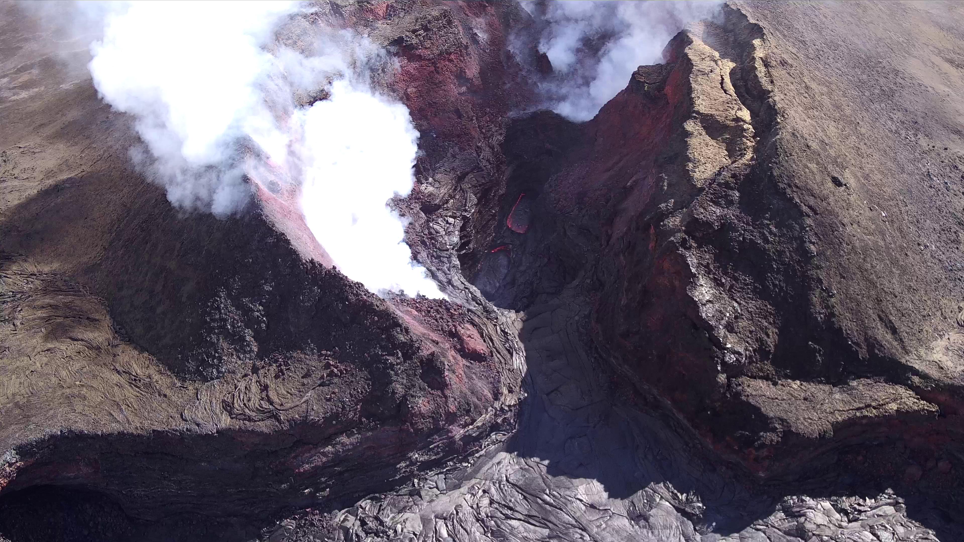
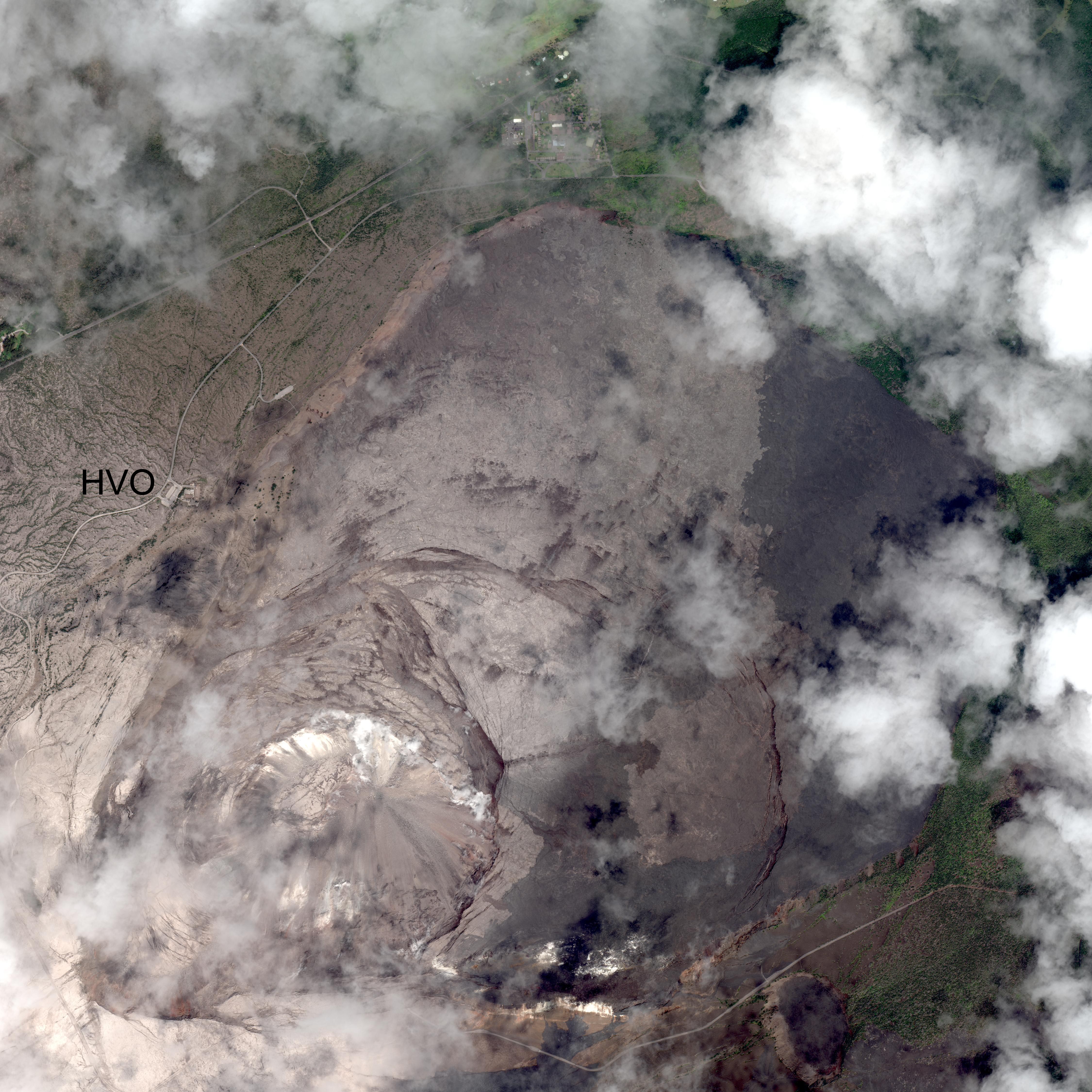
August 19: The Lull Continues

This Week’s Eruption Activity

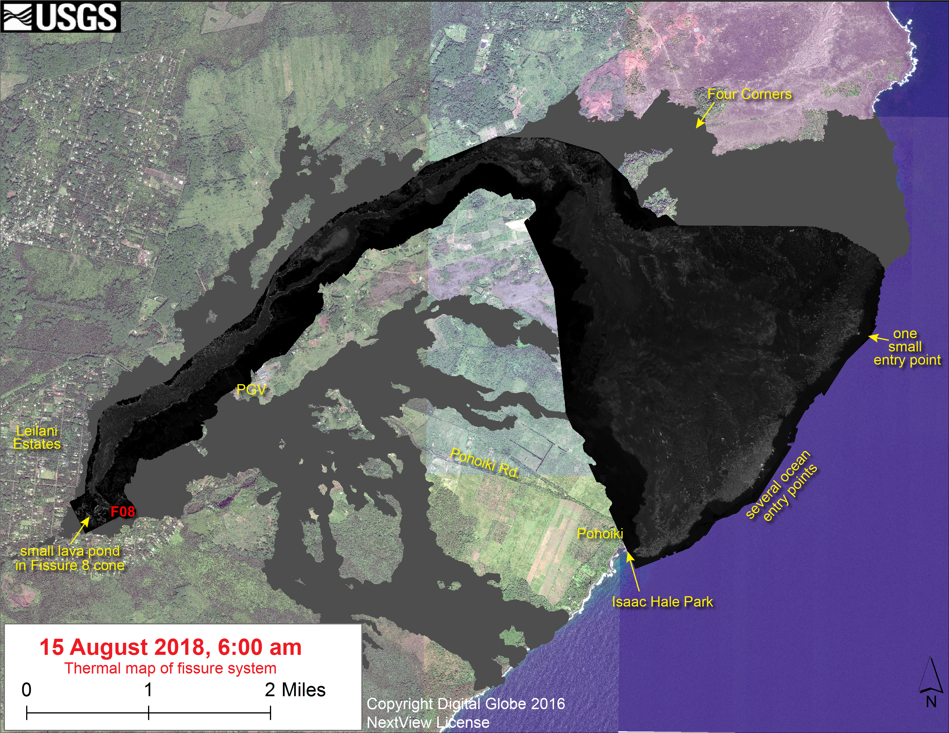
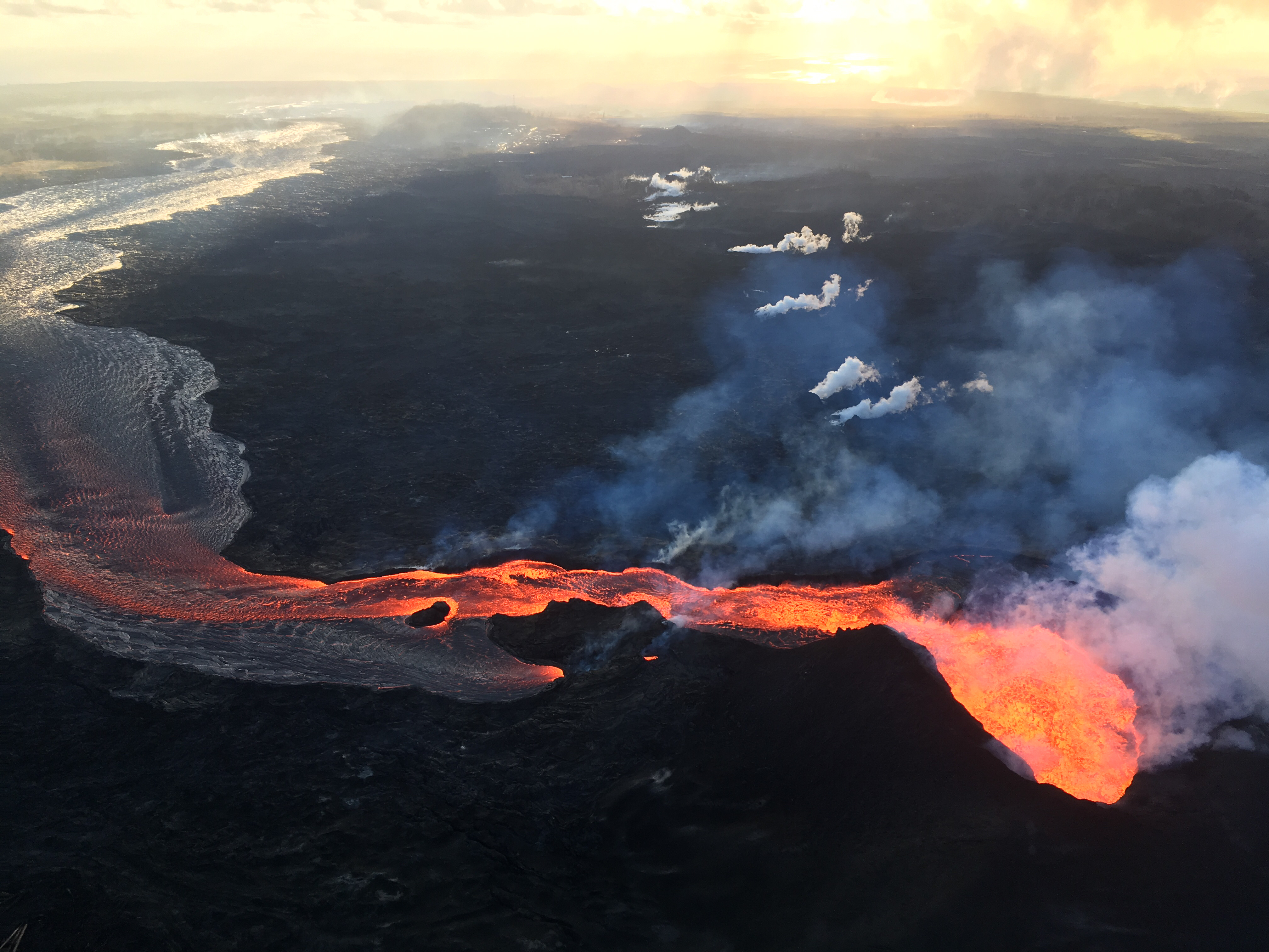
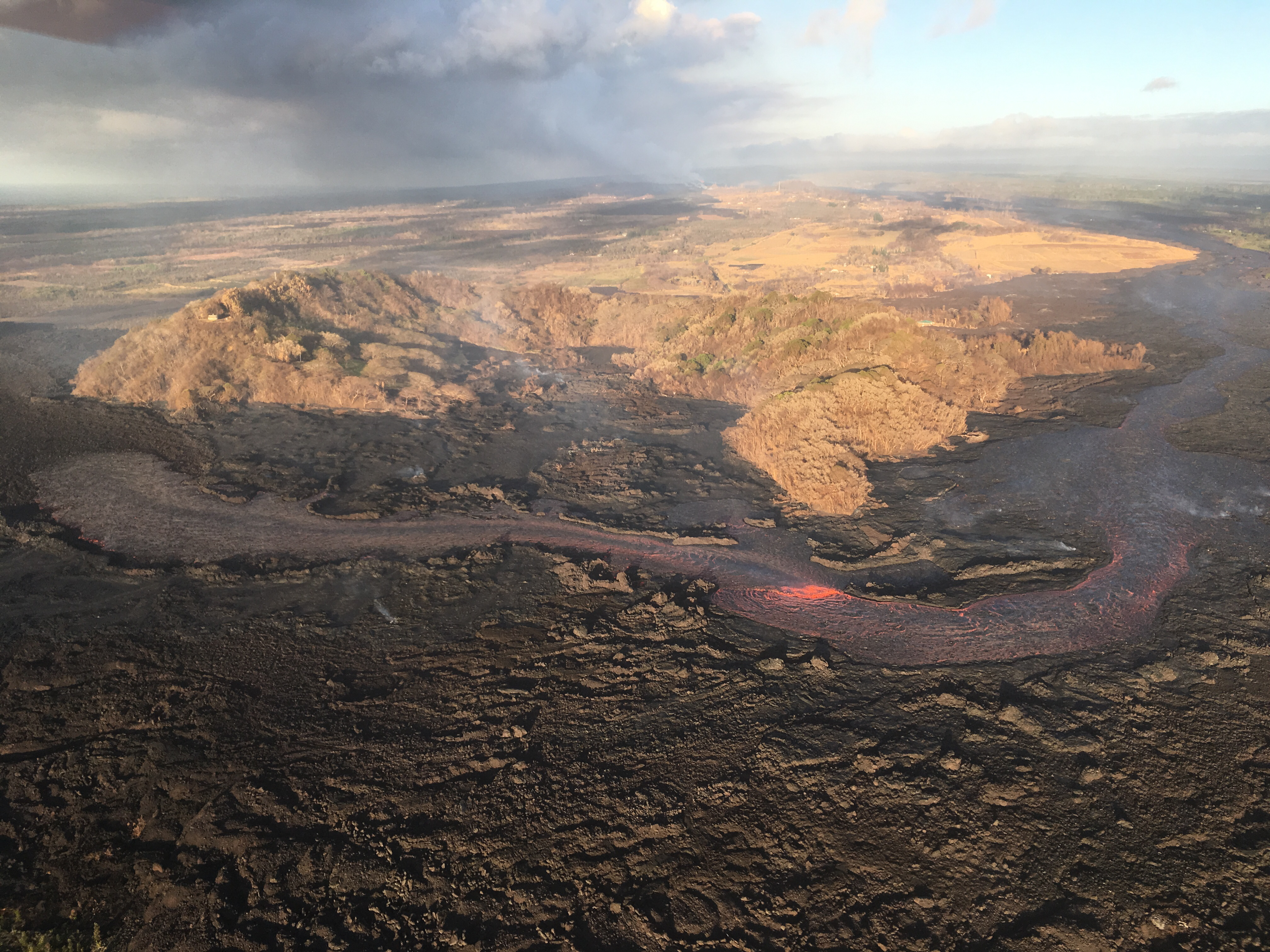
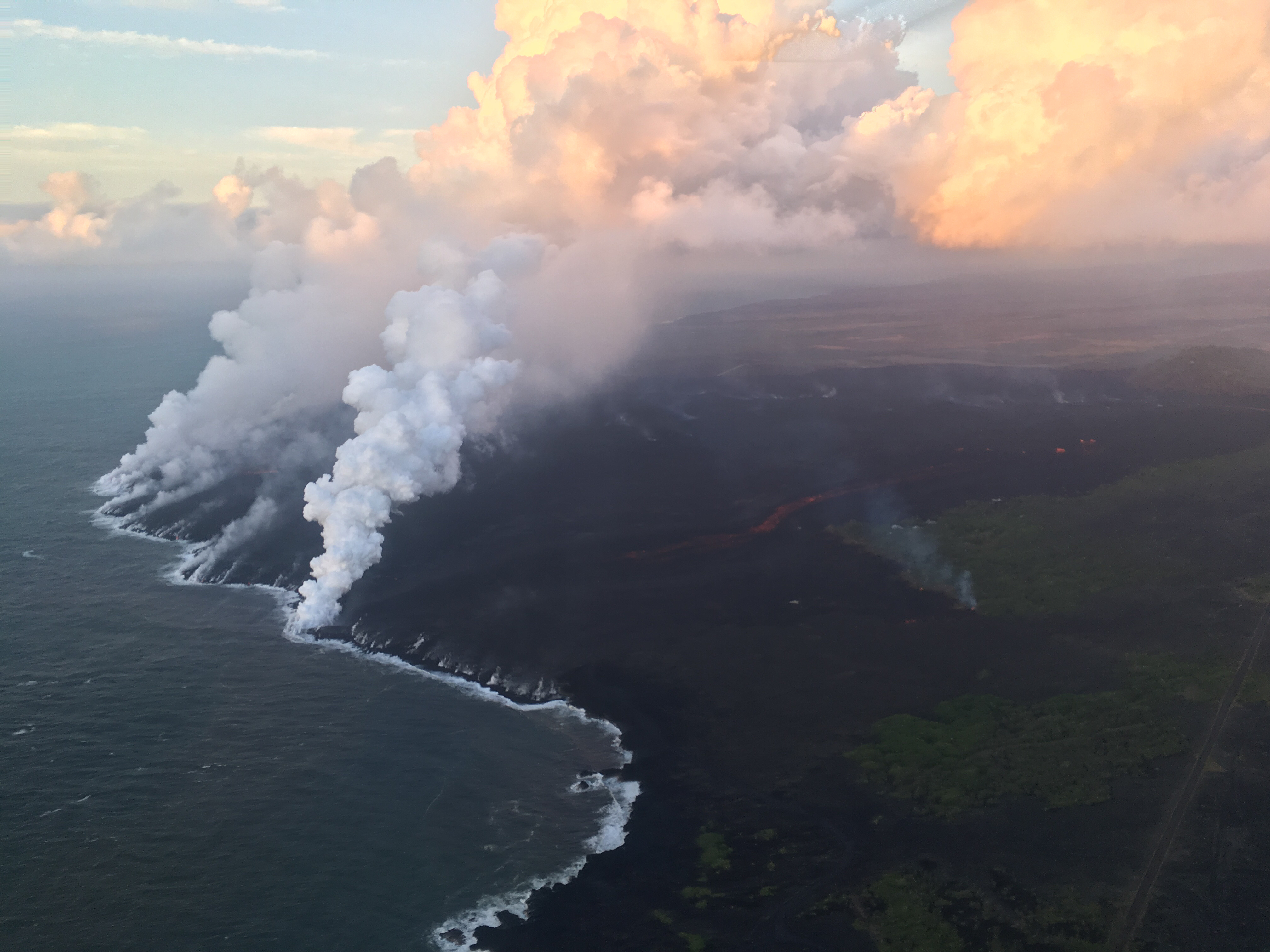
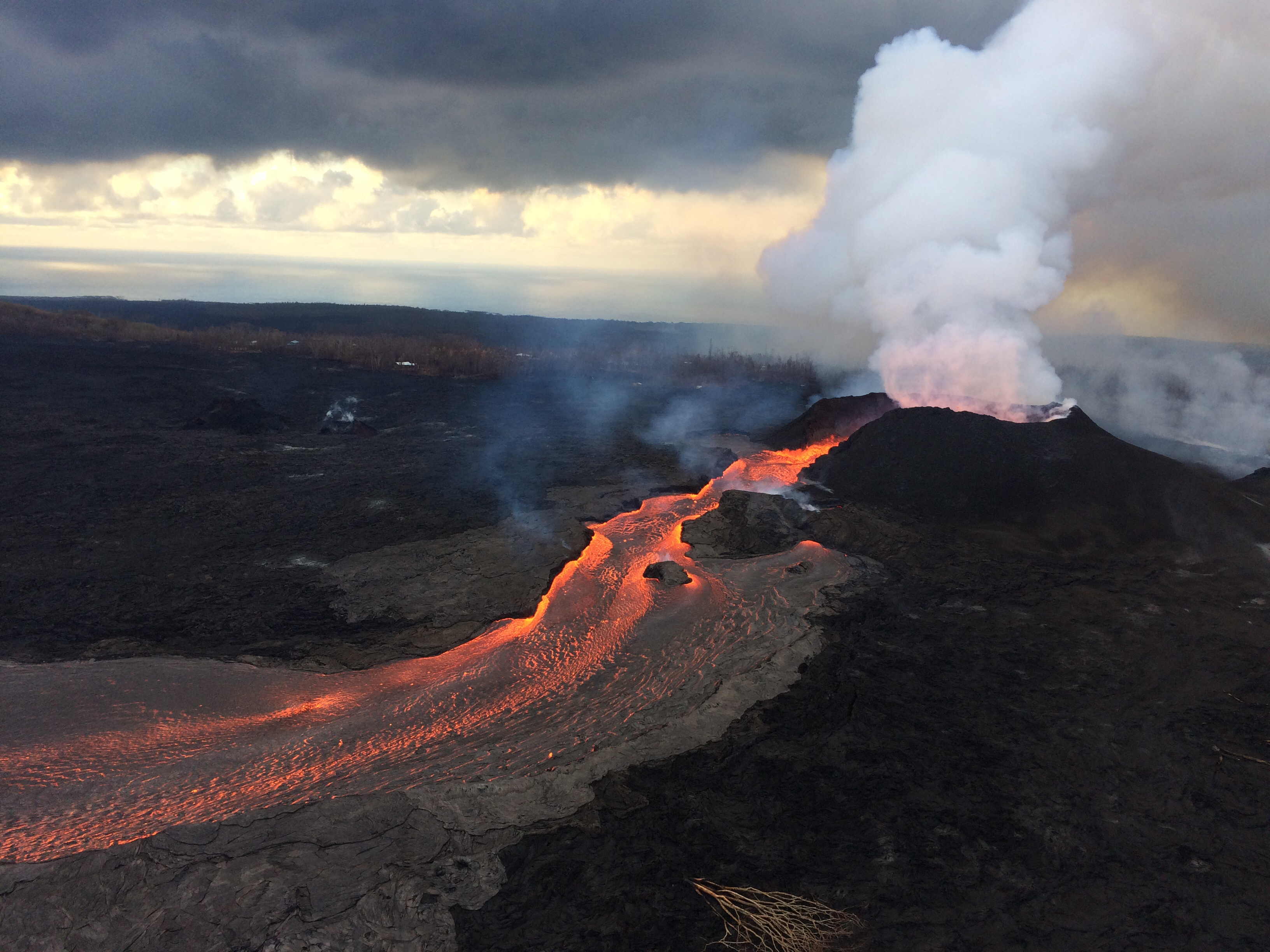
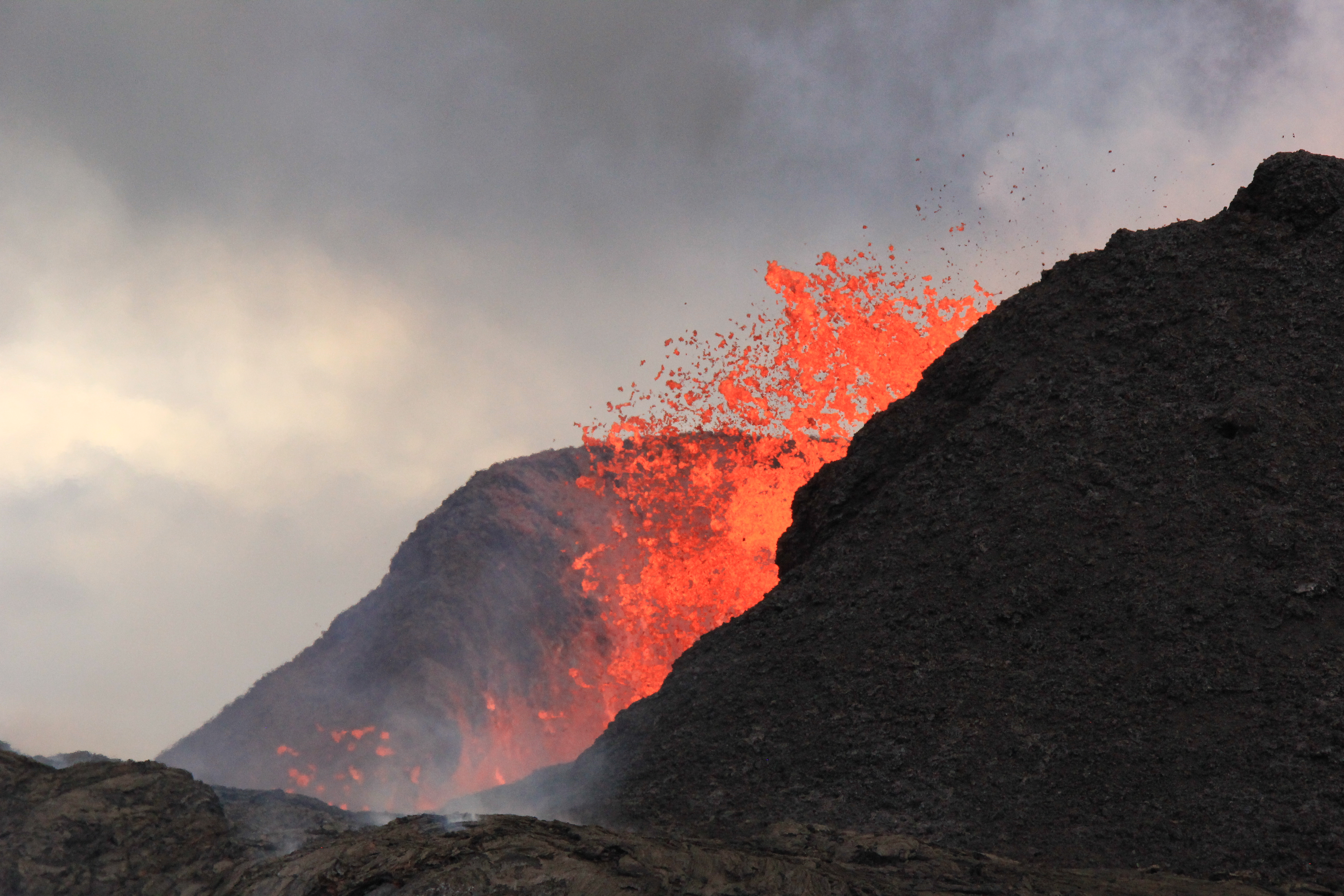
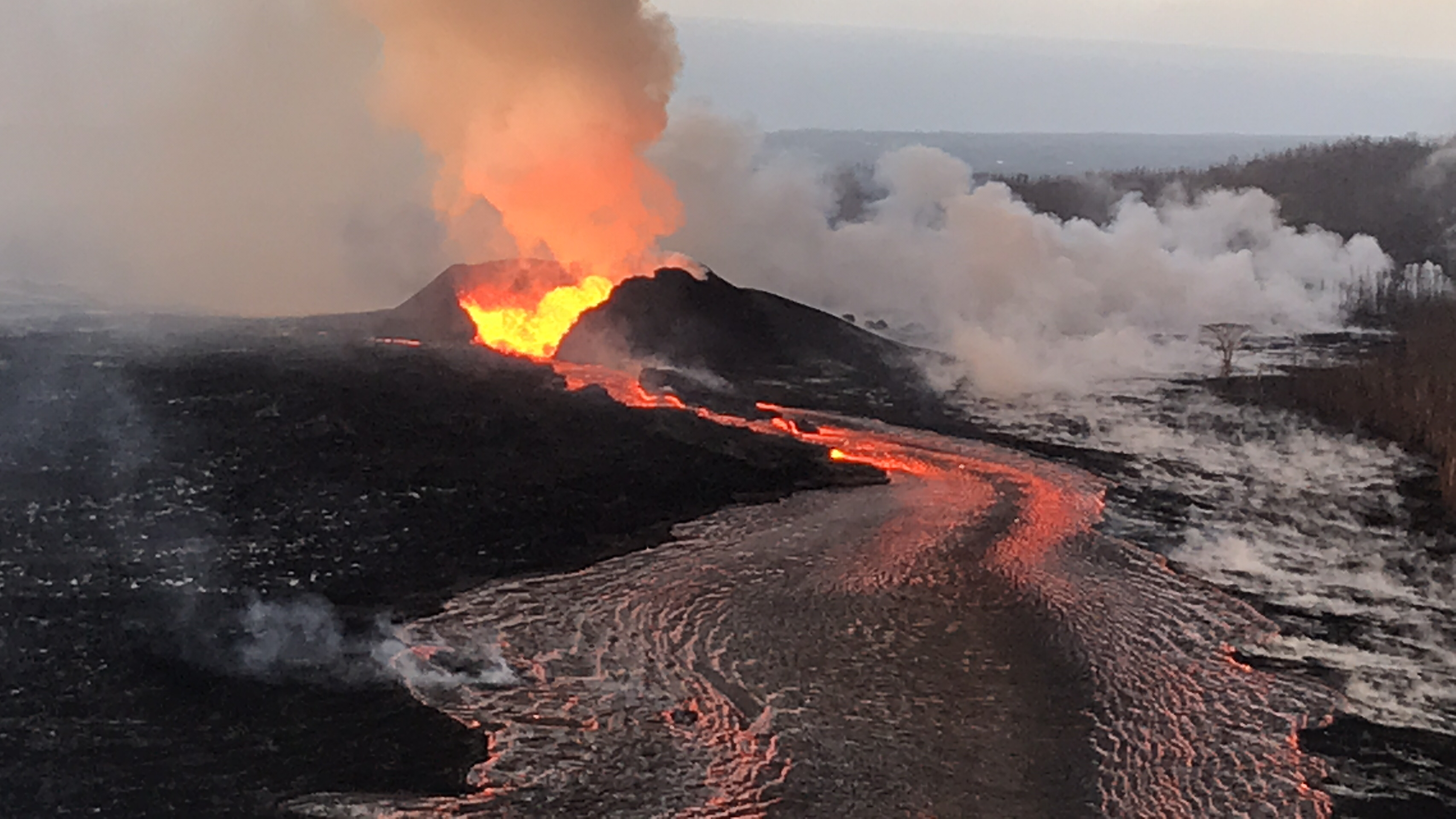
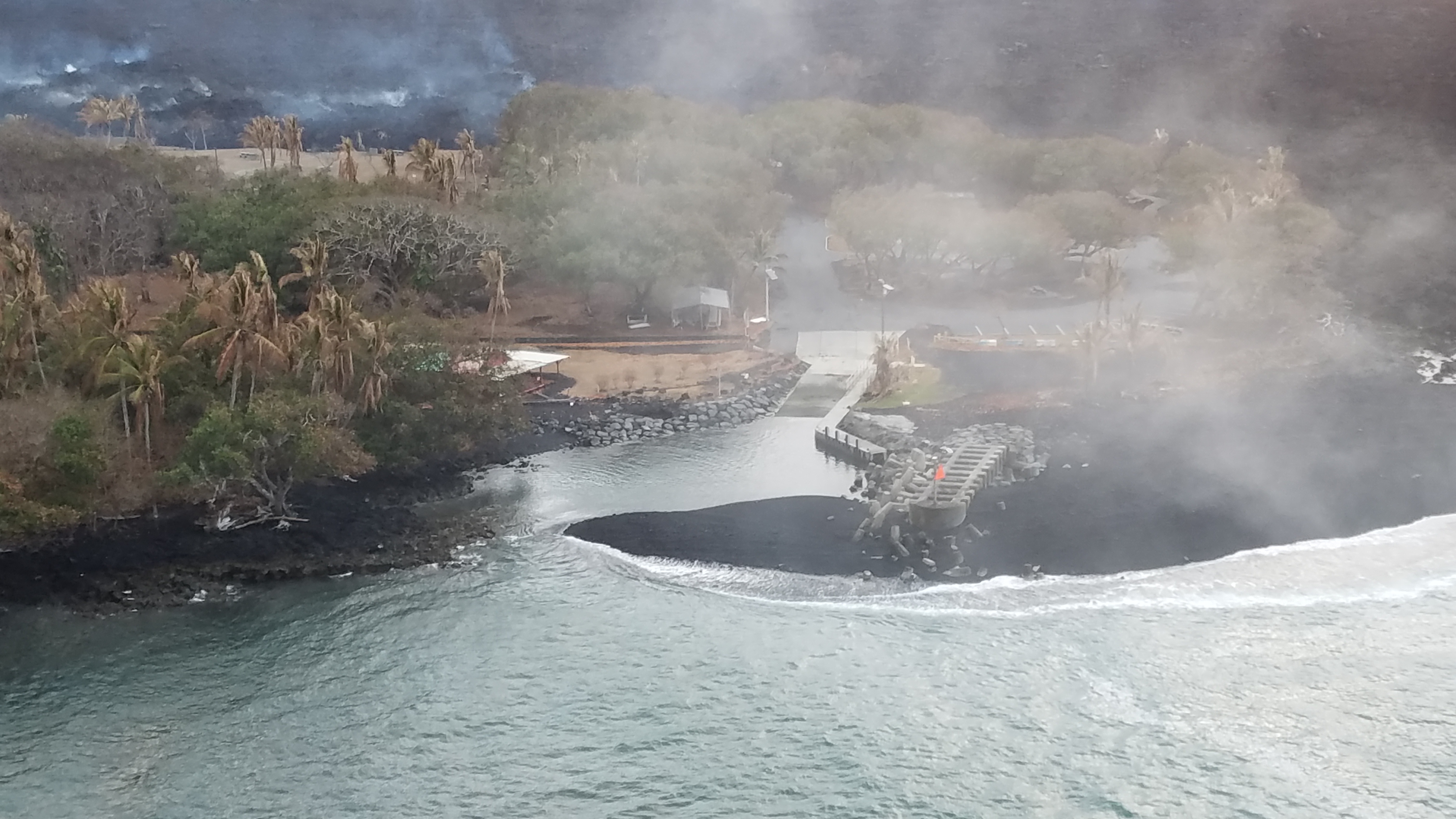
Negligible. There’s a few residual bits of lava oozing into the ocean at Ahalanui. Otherwise, there’s not much going on at the summit or LERZ.

[In case Tweet above isn’t showing, here’s the 3D Fissure 8 video on HVO website.]

USGS: “This thermal map shows the fissure system and lava flows as of 6 am on Wednesday, August 15 [2018]. Residual lava in the Fissure 8 flow continues to drain, feeding numerous small ocean entries. In the Fissure 8 cone there was a single, small lava pond.” (Full-sized)
On Friday August 19, HVO lowered ground alert levels, just as they lowered aviation alert levels after the ash explosions stopped. Here’s the official notice:

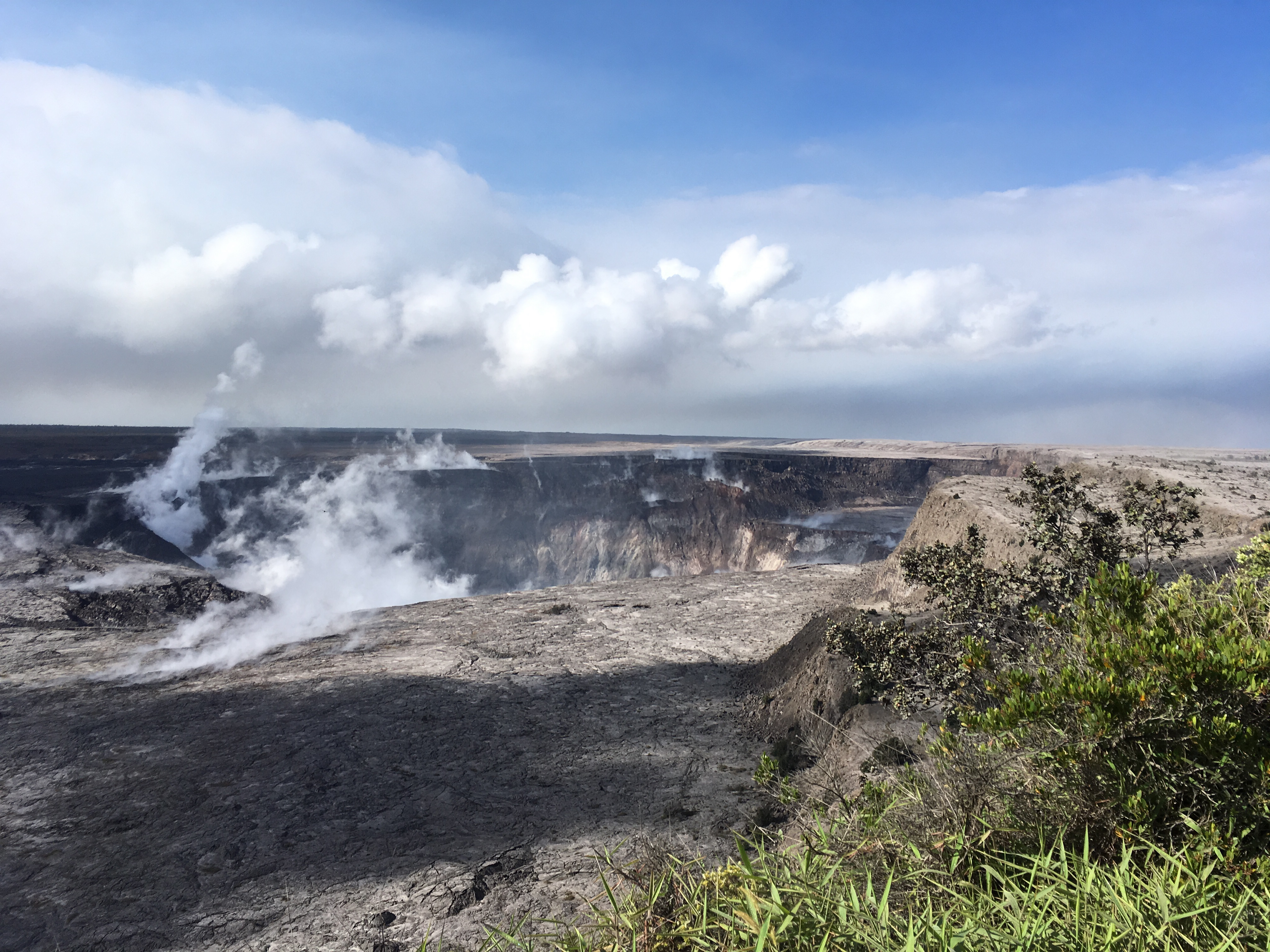
In light of the reduced eruptive activity at Kīlauea Volcano over the last several days, HVO is lowering the Alert Level for ground based hazards from WARNING to WATCH. This change indicates that the hazards posed by crater collapse events (at the Kīlauea summit) and lava flows (Lower East Rift Zone; LERZ) are diminished. However, the change does not mean with absolute certainty that the LERZ eruption or summit collapses are over. It remains possible that eruption and collapse activity could resume.

[…]

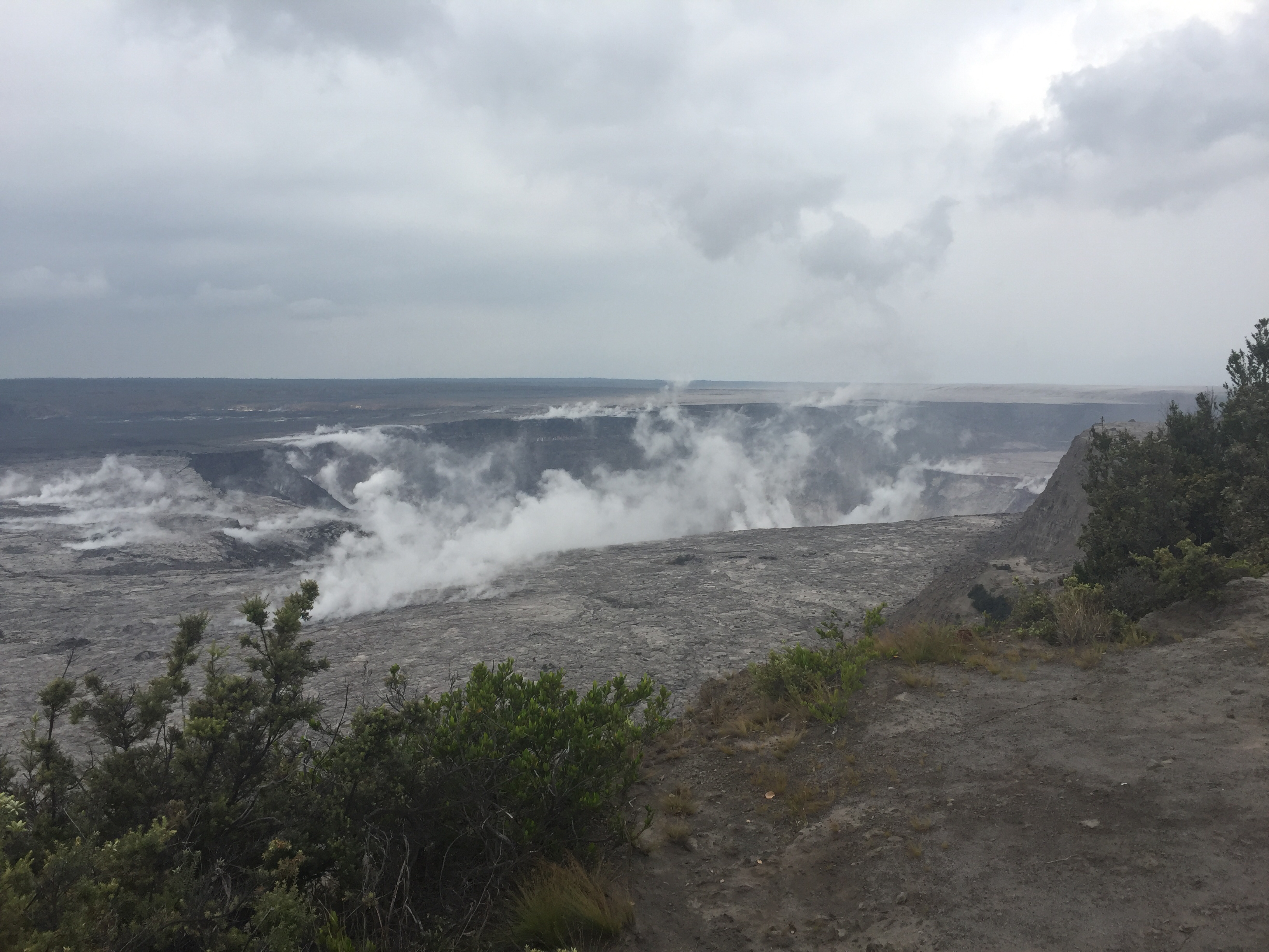
Remarks: Background and Prognosis

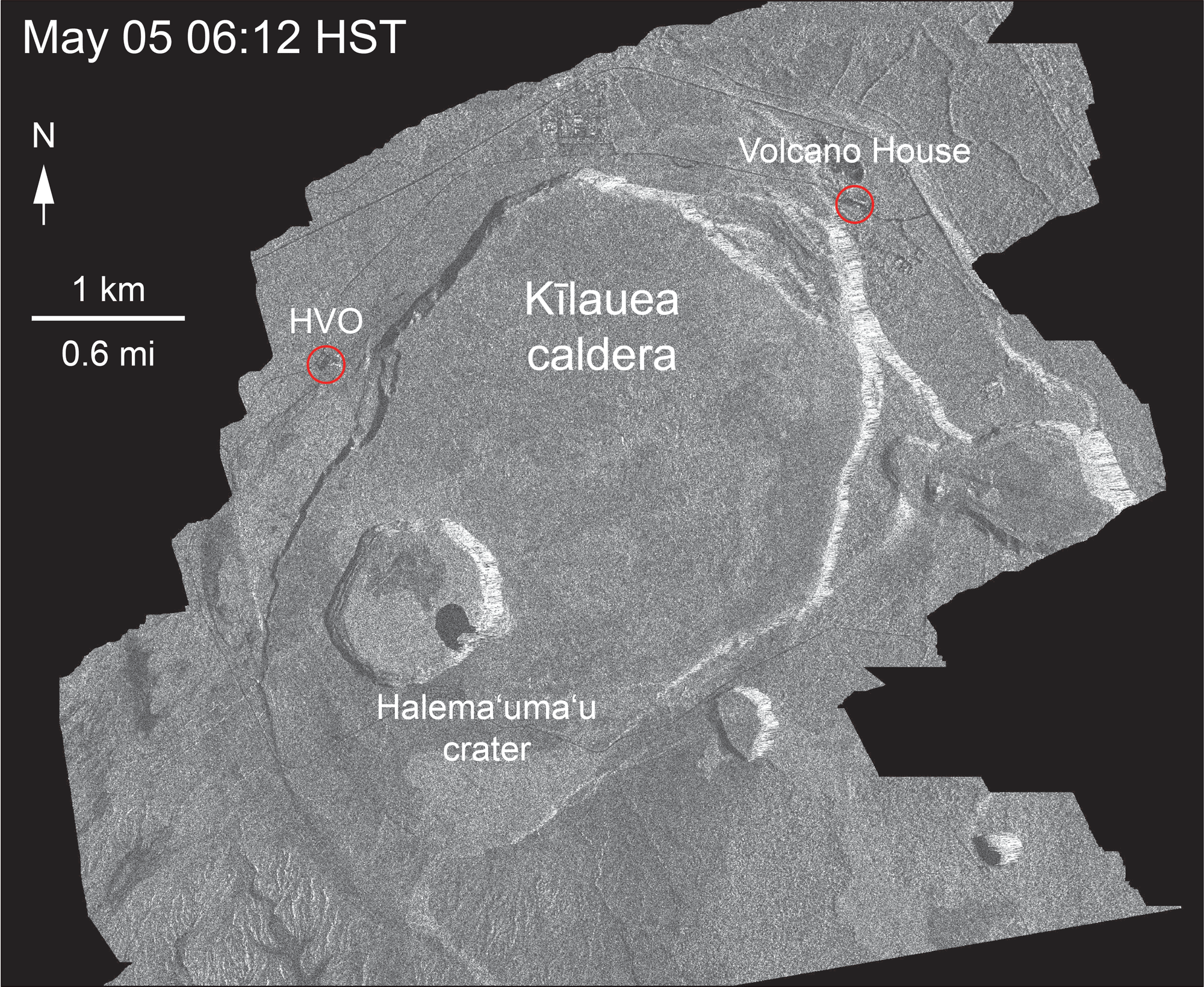
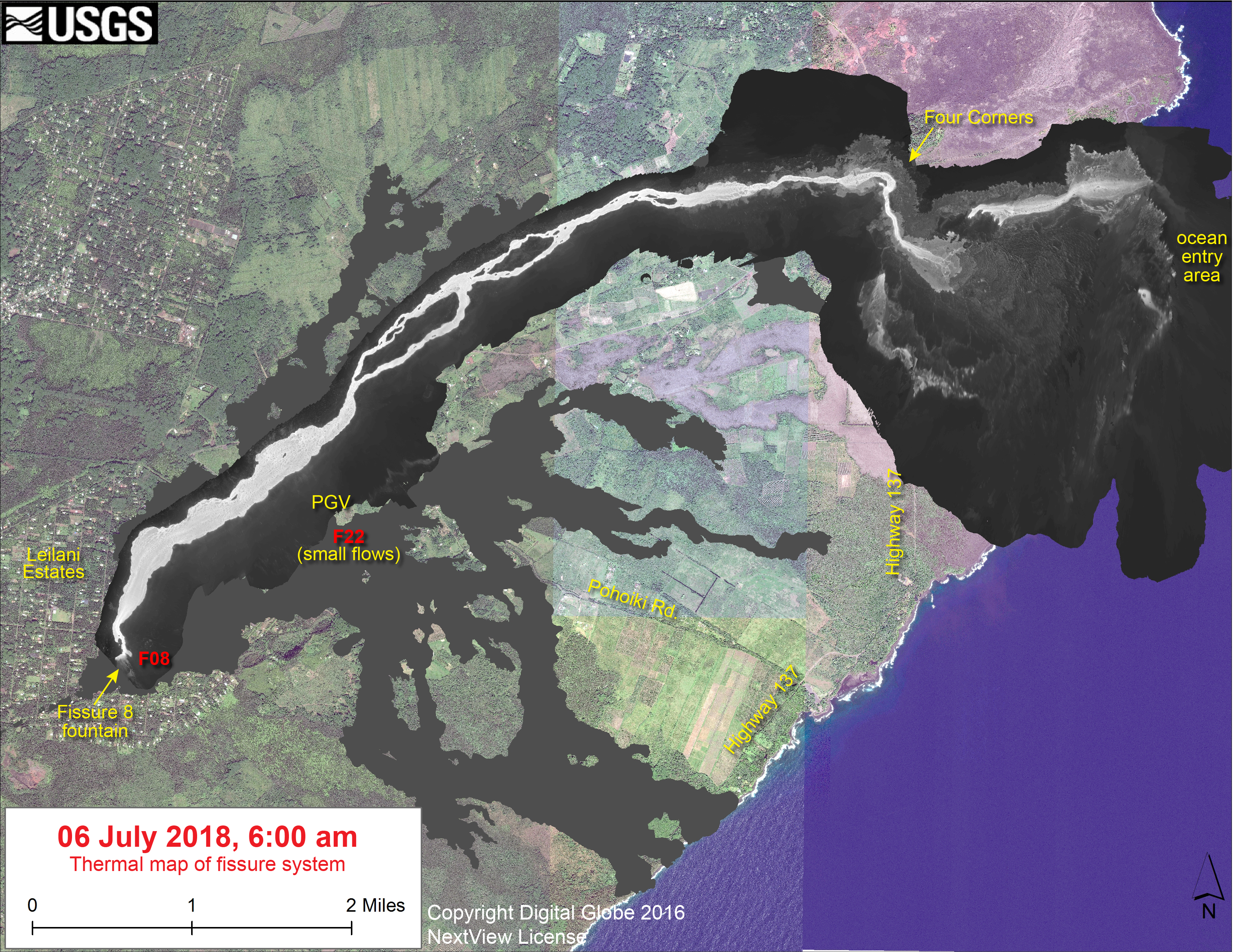
Kīlauea Volcano has remained quiet for well over a week now, with no collapse events at the summit since August 2. Except for a small, crusted-over pond of lava deep inside the fissure 8 cone and a few scattered ocean entries, lava ceased flowing in the LERZ channel on August 6. Sulfur dioxide (SO2) emissions rates at the summit and LERZ are also drastically reduced (the combined rate is lower than at any time since late 2007).

It remains too soon to tell if this diminished activity represents a temporary lull or the end of the LERZ lava flows and/or summit collapses. In 1955, similar pauses of 5 and 16 days occurred during an 88-day-long LERZ eruption. During the Mauna Ulu eruption (1969-1974), a 3.5 month pause occurred in late 1971.

HVO will continue to record detailed visual observations and scrutinize incoming seismic, deformation, and gas data, looking for evidence of significant movement of magma or pressurization as would be expected if the system was building toward renewed activity.

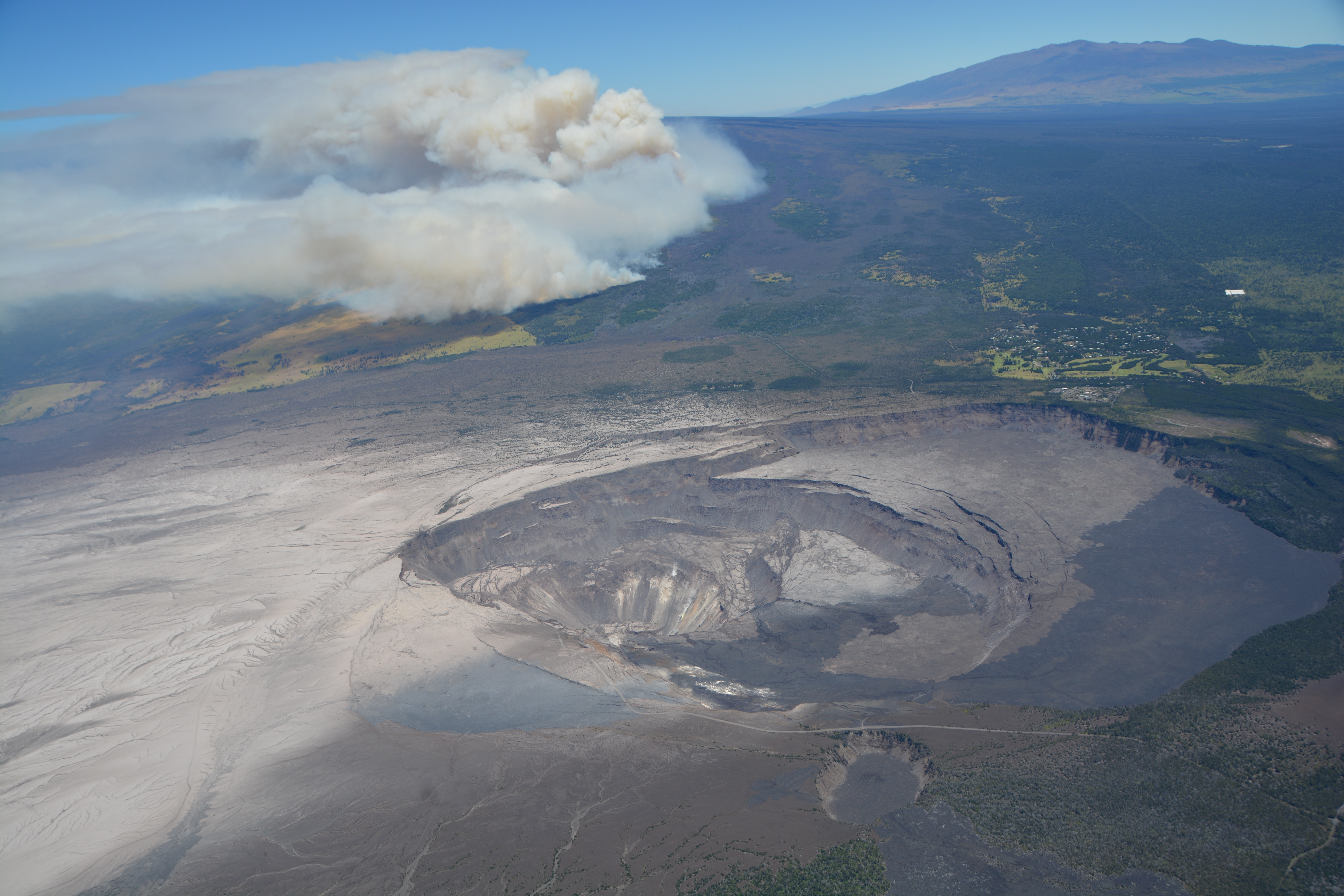
Also on Friday, the National Park Service issued a media release and gave select local media a guided tour of the summit. Lots of info, and worth seeing:

This Week’s USGS Photos From Summit to Sea

Continue reading August 19: The Lull Continues

August 12: Pele Is Still Sleeping, Part 1

August 11, 2018. USGS: “The UAS team (Unmanned Aircraft Systems) flew a mission over fissure 8 to assess conditions within the cinder cone. As shown, fissure 8 contains two small ponds deep within its crater. One pond slowly circulates with an incandescent surface while the other pond is stagnant with a crusted top.” (Fuil-sized)
Weekly Eruption summary

So it’s finally arrived, the end (or at least intermission) of Fissure 8’s endless outpouring of lava from May 27 to August 4. The shutdown happened at the end of last week over a period of just 2-3 days.

August 11, 2018. USGS: “The fissure 8 cinder cone is currently about 30 m (100 ft) tall with a very broad base. Sulfur dioxide (SO2) emissions are low, reflecting the diminished activity of the lava ponds in the cone.” (Full-sized)

Fissure 8 isn’t quite dead. There’s lava pooled deep down the cone, bubbling weakly. Residual lava is still draining out of the lava delta into the ocean, some of it quite near the now-famous Pohoiki Boat Ramp. But most of the surface channels have drained and solidified.

August 11, 2018. USGS: “Close view of the Pohoiki boat ramp during this morning’s overflight. The southern-most flow margin has not advanced significantly toward the Pohoiki boat ramp, but black sand and larger fragments from the entry areas have washed ashore to create a sand bar and beach at this site. Geologists observed several small lava streams trickling into the sea along the souther portion of the lava delta, producing weak laze plumes.” (Full-sized)

The volcano’s summit has settled, too. The caldera floor isn’t inflating or deflating, and the swarms of earthquakes and summit collapses have stopped.

So now the question becomes: how long do geologists, national park staff and residents wait before deciding it’s safe to start repairing the damage? Past Lower East Rift Zone eruptions have paused for days, even weeks. So scientists and officials continue to warn that this eruption could resume at any time.

August 7, 2018. USGS: “Civil Air Patrol captured this image of Kīlauea’s summit yesterday (August 7, 2018), providing a stunning view of Halema‘uma‘u and the collapsed area within the caldera. Prevailing trade winds have blown much of the ash emitted during earlier explosions to the southwest (left), where thin layers of light-colored volcanic ash now blanket the landscape. Plumes of smoke rising from the flank of Mauna Loa were from a brush fire that continues burning today. Mauna Kea is visible on the upper right horizon; the crater visible at bottom center is Keanakāko‘i.” (Full-sized)

This week’s Volcano Watch column from Hawaiian Volcano Observatory, written August 9, addresses exactly that question:

“Is Kīlauea Volcano’s summit and rift zone activity pau or paused?”

Also, it looks like I missed an August 6 USGS news media briefing discussing the eruption’s apparent shutdown (full audio).

Now let’s look back at recent images and videos posted on HVO’s Photo & Video Chronology page, which only shows the 10 most recent posts— so these are visible there now, but won’t be in the future.

First of all, remembering past collapse events— with sound! Full-sized video posted here, or a faster-loading small version on Twitter:

Continue reading August 12: Pele Is Still Sleeping, Part 1

July 31: Record Officially Broken

July 31, 2018. USGS: “The fissure 8 ocean entry and laze plume as they appeared at sunrise this morning. The Pohoiki boat ramp is visible just below the plume (slightly left of center).” (Full-sized)

89 days. That’s how long it’s been since the first fissure started spattering lava in Leilani Estates. Which is one day longer than the 1955 Kapoho eruption, which had been the longest LERZ eruption since records started being kept.

July 31, 2018. USGS: ” In this aerial view, taken during HVO’s overflight this morning, you can follow the lava channel from fissure 8 (gas plume visible in far distance) as it wends its way toward Kapoho Crater (lower left), where it then heads south toward the ocean.” (Full-sized)
Today’s Eruption Summary

LERZ erupton as per usual. There’s “ooze-outs” of lava on the flow margin, but further inland from Pohoiki. Today’s M5.3 summit collapse was at 7:59 am, when the crater was steaming in the cool morning air.

From HVO, the livestream caught the pressure wave passing through the cloud:

From the NE Caldera Rim livestream, ground shaking and rockfalls were more visible:

There was also a regular M 4.5 earthquake at 12:30 am.

HVO/USGS has updated and reorganized their 2018 Activity page, with FAQs, resources, and links to photos and videos.

Continue reading July 31: Record Officially Broken

July 8: Ahalanui Warm Pond, School Under Lava Threat

Today’s Eruption Summary

The LERZ continues as usual, although there are tantalizing hints that change could be on the way:

July 8, 2018. USGS: “Fissure 8 (lower right) and open lava channel leading to the northeast. Geologists noted small lava-level fluctuations in the open channel overnight, which indicates intermittent variations in lava discharge from fissure 8. An increase in lava levels was noted about 1.5 hours after the collapse-explosion event at the volcano’s summit at 02:55 a.m. HST. Evidence of a couple of recent, short-lived channel overflows were observed early this morning, but they had not reached the edge of the flow field. The small steam plumes in distance mark locations of fissures that erupted in early May at the beginning of the ongoing eruption.” (Full-sized)

Fissure 8 gushes within its large cone, Fissure 22 continues to spatter weakly. The open lava channel from Fissure 8 now ends about 2km (1.2 mi) from the coast:

July 8, 2018. USGS: ” View of the partially filled Kapoho Crater (center) and the open lava channel where it makes a 90-degree turn around the crater. The open channel no longer directly enters the ocean. Lava flows freely through the channel only to the southern edge of Kapoho Crater (left side of image). Clearly, lava moves into and through the molten core of the thick ‘a‘ā flow across a broad area from both the sides and end of the channel.” (Full-sized)

From the end of the channel, the lava dives under the crust of the slightly older flows that buried Kapoho Bay. It emerges again along a very broad ocean entry:

July 18,2018. USGS: “Multiple ocean entries were active this early morning, each contributing to the prominent “laze” plume above the area. Lava moves from the open channel through the molten core of the broad ‘a‘ā flow field to the ocean. Kapoho Crater is at middle right of photo.” (Full-sized)

According to USGS/HVO, the ocean entry is “primarily along the northern section,” as it has been for the past few weeks. However, to judge by today’s @hotseasthawaii overflight, there’s notable ocean entries to the south as well. Besides the lava that reaches the ocean, USGS reported lava “oozing out” to the north and southwest of the main a’a field just inland, as one can see on Friday’s thermal map. A few Kapoho Beach Lots houses are hanging on, threatened by the northern “ooze-out.” The southwestern “ooze-out” — several local photographers have reported an unconfirmed  “southern lobe” lava flow— is within a few hundred yards of Ahalanai Warm Pond and Kua O Ka La Charter School:

Screencap from early morning July 8 HotseatHawaii overflight. Ahalanui Warm Pond is just at the end of that straight stretch of Hwy 137, and the school is the light-colored patch just to the right of it. (Full-sized)

The most recent summit collapse event occurred at 2:55am HST, July 8, with an energy release of M5.4.

Italy’s Cosmo-Skymed satellite sent down another radar image of Kilauea caldera today:

July 8, 2018. USGS: “This animated GIF shows a sequence of radar amplitude images that were acquired by the Agenzia Spaziale Italiana CosmoSkyMed satellite system. The images illustrate changes to the caldera area of Kīlauea Volcano that occurred between May 5 and July 8 at about 6:00 a.m. HST. […] The most recent radar scene, from July 8, shows continued motion along cracks over a broader area of the caldera floor, extending east of Halema’uma’u (these cracks are the scarps seen in recent photographs from the Keanakākoʻi overlook area).” (Full-sized)
Continue reading July 8: Ahalanui Warm Pond, School Under Lava Threat

July 6: Living With the 1% Possibility of Caldera Collapse

USGS, July 6, 2018. Dawn at Fissure 8. (Full-sized)
Today’s Eruption Summary

The Lower East Rift Zone eruption continues pretty much as usual: Fissure 8 feeding a lava river with occasional short-lived overflows. The main lava channel no longer reaches the ocean, but crusts over a half mile from shore and dives into the lava delta, oozing out at multiple points on the northern side. One especially large “ooze-out” makes a short flow on the north side of the flow field near the last few Kapoho Beach Lot Houses, a few of which are hanging on. Fissure 22 is weakly spattering with a weak flow to its east. Today’s summit explosion occurred at 6:04pm, equivalent of M5.3. Thick fog obscured the livestream view.

July 6, 2018, USGS. Ocean Entry at Kapoho. (Full-sized)

So that’s all routine, if a volcanic eruption can ever be routine. The big news today actually took place last night (see what happens when I finish my posts early?):

July 5 Volcano Community Meeting

Thursday evening, there was an important community meeting in Volcano Village. Mayor Harry Kim, the USGS and Civil Defense outlined the extremely unlikely but potentially life-threatening (to people near the summit) possibility of large-scale caldera collapse. I’ve transcribed the meeting here. BigIslandVideoNews excerpted the crucial 4-minute presentation from HVO’s Tina Neal:

Preceding this meeting was a long-expected document from USGS: Volcanic Hazard at the Summit of Kīlauea UpdateWhile the Kīlauea Summit Earthquakes FAQ explained what is happening, this new update to a May 8th report summarizes what the USGS thinks might happen at the summit before this sequence is over, based on the volcano’s distant past.

During the Q&A session, a resident asked about the odds for the worst-case scenario, a large-scale caldera collapse with explosive activity. Harry Kim took the mike from Tina Neal and said, “Like you, we always like to know percentage odds. And she knows; I asked her that. And I’d like to answer because she said, ‘One percent.'” [Tina went on to explain how they arrive at such probabilities; she wasn’t being flippant.]

Another reassuring quote from the Q&A session:

Don Swanson: “I think that the evidence we have today looks to me as if [the subsidence/collapse] is going to be confined to within the caldera, because the outermost circumferential fractures that have been occurring on the caldera floor have not extended outward in the last 2-3 weeks or so. So to me, that suggests that they may be defining the outermost limit of potential caldera collapse.”

USGS: “The WorldView-3 satellite acquired this view of Kīlauea’s summit on July 3. Despite a few clouds, the area of heaviest fractures in the caldera is clear. Views into the expanding Halema‘uma‘u crater reveal a pit floored by rubble. HVO, on the northwest caldera rim, is labeled.” (Full-sized)

Continue reading July 6: Living With the 1% Possibility of Caldera Collapse

June 22-28: Kilauea Webcam Timelapses

`Hawaii 24/7 puts out weekly timelapse videos collecting all the screencaps from the USGS/HVO webcams.

Wide Angle HVO Observation Tower

Past timelapses: May 10-17| May 17-24May 24-31| Jun 1-7| Jun 7-14 | Jun 13-22

Kilauea Caldera (Halema’uma’u Panorama)

Past timelapses: (older) |  Mar 29-Apr 5 |  Apr 5-12Apr 12-19 |  Apr 19-26 |  Apr 26-May 6  | Apr 26-May 3May 3-10May 10-17May 17-24| May 24-31Jun 1-7 | Jun 7-14 | Jun 13-22

Halema’uma’u Overlook Vent (former!)

Past timelapses:  (older) |  Mar 29-Apr 5Apr 5-12 |  Apr 12-19Apr 17-26Apr 26-May 6 | Apr 26-May 3May 3-10May 10-17May 17-24May 24-31 | Jun 1-7 | Jun 7-14 | Jun 13-22

Lower East Rift Zone (Fissure 8)

Past timelapses: May 5-10 |  May 10-17| May 17-24May 24-31| Jun 1-7Jun 7-14 | Jun 13-22

And here’s a search for Pu’u O’o webcam timelapses on this channel. (Why, Google, don’t you let us sort them in order?!)

June 24: Aviation Color Code Dropped to Orange

Today’s Eruption Summary

The new news today is that HVO/USGS downgraded Kilauea’s FAA warning level:

“Since late May, these collapse/explosion events have rarely produced significant ash plumes rising more than 10,000 feet above sea level where they can pose a significant hazard to aviation. For this reason, HVO is reducing the aviation color code from RED to ORANGE.”

Full text of this HVO Volcanic Activity Notice | Guide to Codes

June 24, 2018. USGS early morning overflight of Fissure 8. (Full-sized)

I almost feel like the recent code downgrades for Kilauea and Mauna Loa were a tacit rebuttal of the scaremongers trying to conjure an island-wide catastrophe out of hot air. But I suppose I’m being as irrational as they are. There were specific numbers and criteria for both these status changes.

Down at the LERZ, status quo continues. Fissure 8’s lava fountains are vigorous but seldom peep over the cone they’ve built (now 180′). Minor overflows spill out near the head of the lava river without going far. The ocean entry is concentrated mostly at the main lava channel channel near the south end of the lava delta, but some fans out along a 1km stretch.

USGS: “The spatter cone at fissure 8 is now about 55 m (180 ft) tall. Lava fountains rise only occasionally above that point, sending a shower of tephra (cooled lava fragments) over the rim.” (Full-sized)

Today’s collapse explosion went off at 4:12pm, M5.3, partly hidden on the livestream by a dust cloud from rockfalls 4 minutes earlier. Just as yesterday, I noticed the “collapse explosion” started with a visible camera shake, unlike earlier rockfalls that made me think, “Waaaaait— was that it?” The explosion itself didn’t send up much dust past the rim of Halema’uma’u. About a minute later, dust from caldera wall rockfalls (I think?) blew past.

Below: Rockfalls, dust cloud, then I fast forwarded to the collapse explosion.

Today’s USGS Kilauea update gave additional details for yesterday’s explosion which probably apply to today’s as well: “Seismicity dropped abruptly from a high of 25-30 earthquakes per hour (many in the magnitude 2-3 range) prior to the collapse explosion down to 10 or less earthquakes per hour afterwards. Within 4 hours seismicity began to creep up again averaging about 25 earthquakes per hour by daybreak (June 24)” i.e. about 14 hours later.

Continue reading June 24: Aviation Color Code Dropped to Orange

June 13-22: Kilauea Webcam Timelapses

Hawaii 24/7 puts out weekly timelapse videos collecting all the screencaps from the USGS/HVO webcams.

Lower East Rift Zone (Fissure 8)

Past timelapses: May 5-10 |  May 10-17| May 17-24May 24-31| Jun 1-7Jun 7-14

Wide Angle HVO Observation Tower

Past timelapses: May 10-17| May 17-24May 24-31| Jun 1-7| Jun 7-14

Kilauea Caldera (Halema’uma’u Panorama)

Past timelapses: (older) |  Mar 29-Apr 5 |  Apr 5-12Apr 12-19 |  Apr 19-26 |  Apr 26-May 6  | Apr 26-May 3May 3-10May 10-17May 17-24| May 24-31Jun 1-7 | Jun 7-14

Halema’uma’u Overlook Vent (former!)

Past timelapses:  (older) |  Mar 29-Apr 5Apr 5-12 |  Apr 12-19Apr 17-26Apr 26-May 6 | Apr 26-May 3May 3-10May 10-17May 17-24May 24-31 | Jun 1-7 | Jun 7-14

And here’s a search for Pu’u O’o webcam timelapses on this channel. (Why, Google, don’t you let us sort them in order?!)

June 22: Four Weeks of Changes at Kilauea Summit

Today’s Eruption Summary
USGS: ” Lava continues to erupt at a high rate from Fissure 8 and flow within the established channel to the ocean. No channel overflows were observed during this morning’s overflight. The fountains have built a horseshoe-shaped cone as lava fragments are intermittently hurled onto and over the growing rim. Lava exiting the cone forms a series of standing waves in the uppermost section of the channel.” (Full-sized)

Fissure 8 continues as usual, sending its lava river down to the ocean at Kapoho, with a “dominant ocean entry on the south edge of the flow front…producing a large laze plume.” Minor, brief overflows upstream aren’t traveling past previous lava flows. Fissure 6 is inactive; 16 incandescent; 22 woke up and was fountaining weakly during  the USGS morning overflight.

USGS: “Halema’uma’u crater at 8:30 a.m., view is toward the south. Several benches are clearly visible within the crater. The benches are sections of the former crater rim and adjacent Kīlauea caldera floor that have incrementally dropped or slumped into the crater as the summit area has subsided since early May.” (Full-sized)

Seismicity at the summit was “elevated overnight” according to today’s only HVO status update at 8:45 am. There appeared to be a lot of rockfalls/isolated slippages on the livestream today, especially on the left rim, but the really-truly “collapse explosion” (as USGS is now calling them) occurred at 6:52pm, 5.3 energy equivalent, 500 foot ash plume.

I spent this afternoon putting together a gif of the last 28 days of HVO wide angle Kilauea images, using screencaps I’ve taken supplemented with screengrabs from the same webcam archived by Hawaii247:

Halema’uma’u Crater, May 24-June 22. Animation of screencaps from USGS/HVO Kilauea Summit wide-angle webcam. (Full-sized)

Yikes.

In today’s digest:
  • Video capture of today’s summit explosion (warning: dark)
  • USGS Questions and answers
  • crisp LERZ photos/videos from HCFD
  • Local news stations turning from lava to recovery
  • Double dose of Mick Kalber overflight vids
  • Usual striking images from great photographers

In case you missed it:
Transcriptions of June 19 Steve Brantley Presentation at Puna Community MeetingJune 21 Conference Call

Continue reading June 22: Four Weeks of Changes at Kilauea Summit

June 21: USGS Media Conference Call

Here’s my transcription of the June 21, 11AM USGS media conference call.

  • Host: Leslie Gordon, USGS Public Affairs
  • Mike Zoeller, UHI Geologist
  • Matthew Foster, NWS meteorologist
USGS: “The USGS UAS (unoccupied aircraft system) team took this photograph of Halema‘uma‘u Crater from the Kīlauea Overlook on this morning. They are preparing for a flight to map further subsidence at the summit.” (Full-sized)
Summary:

Update: Status quo at Fissure 8, LERZ, Summit. New “tidbit”: front of lava is sitting on ocean floor that was 60 meters deep. Also, using term “collapse explosion” for daily explosions, because not 100% clear whether explosion triggers collapse or vice versa. Tradewinds and showers through weekend.

Questions & answers: 

  1. Q: Possibility of new fissures opening, or if not, why not? Has seismicity in LERZ decreased? A: Not ruling it out, but magma has found a good conduit to Fissure 8, seems stable. Seismicity in LERZ “pretty quiet.”
  2. Q: Trump administration tightening rules on USGS speaking to reporters; will that impact our communications? 

Leslie Gordon, USGS Public Affairs: That will not affect what we’re doing here at Kilauea. I think the department realizes that this is an urgent situation. We have people’s livelihoods endangered. People have lost their homes and businesses. And so we— it will not affect what we’re doing here regarding Kilauea Volcano.

3. Q: Do you think it’s safe local residents to view lava if they’re outside mandatory evacuation zone?  A: Not our call. It’s up to Hawaii County.
4. Q: What’s process for naming fissure 8? A: Hawaiian elders, community, Board on Geographic Names decide when and what to call places in Hawaii.
5. Q: Will delta collapse? How far out? A: Can’t rule out collapse, but it’s on fairly stable slope so far; 100-200 meters from where it is now the slope steepens. [Didn’t say what would happen there, but I think implication is that it will be less stable and more collapse-prone.]

Continue reading June 21: USGS Media Conference Call