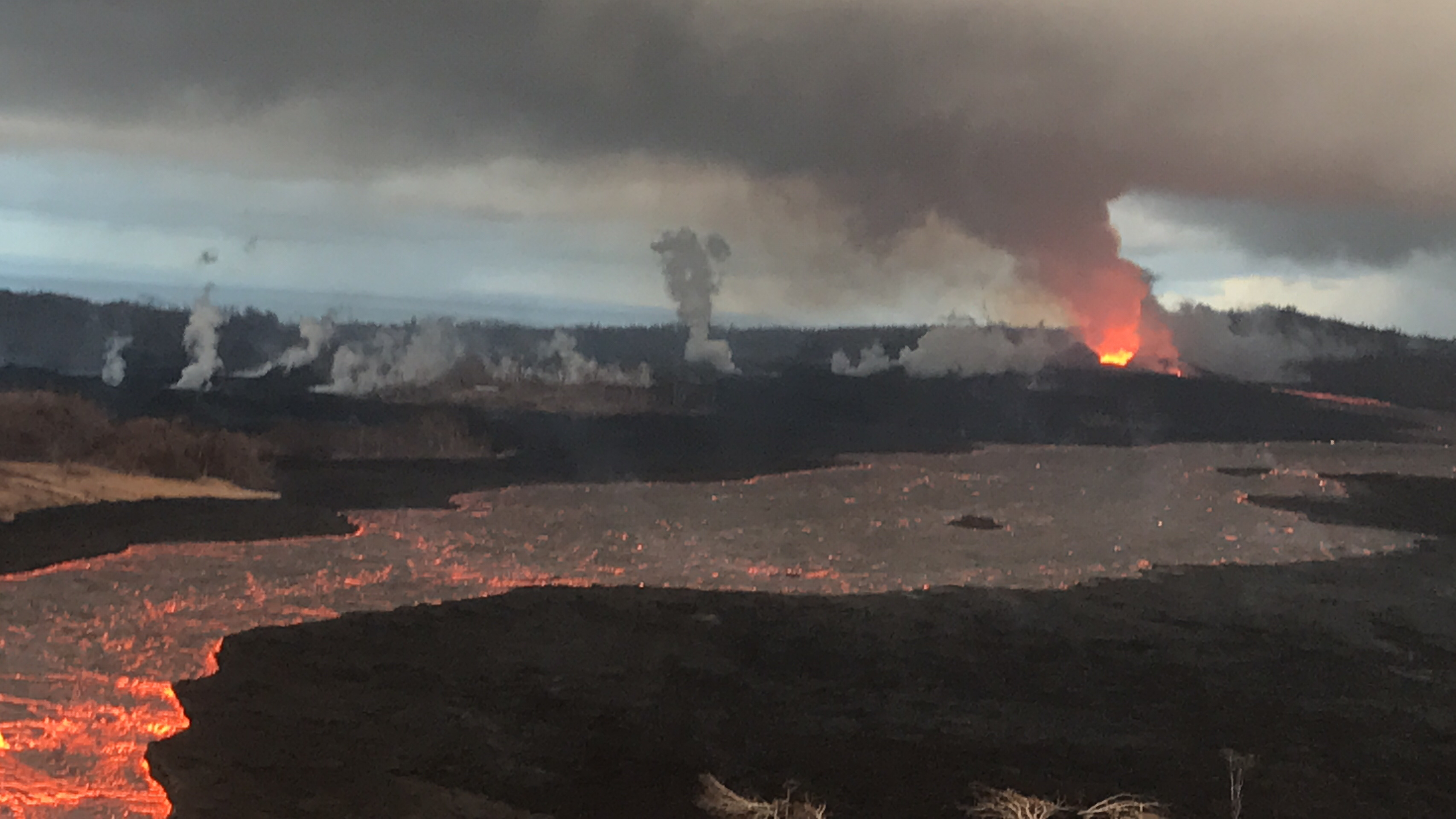
July 7, 2018. A brooding Mordor-scape around Fissure 8 during the USGS morning overflight. (Full-sized)
Today’s Eruption Summary
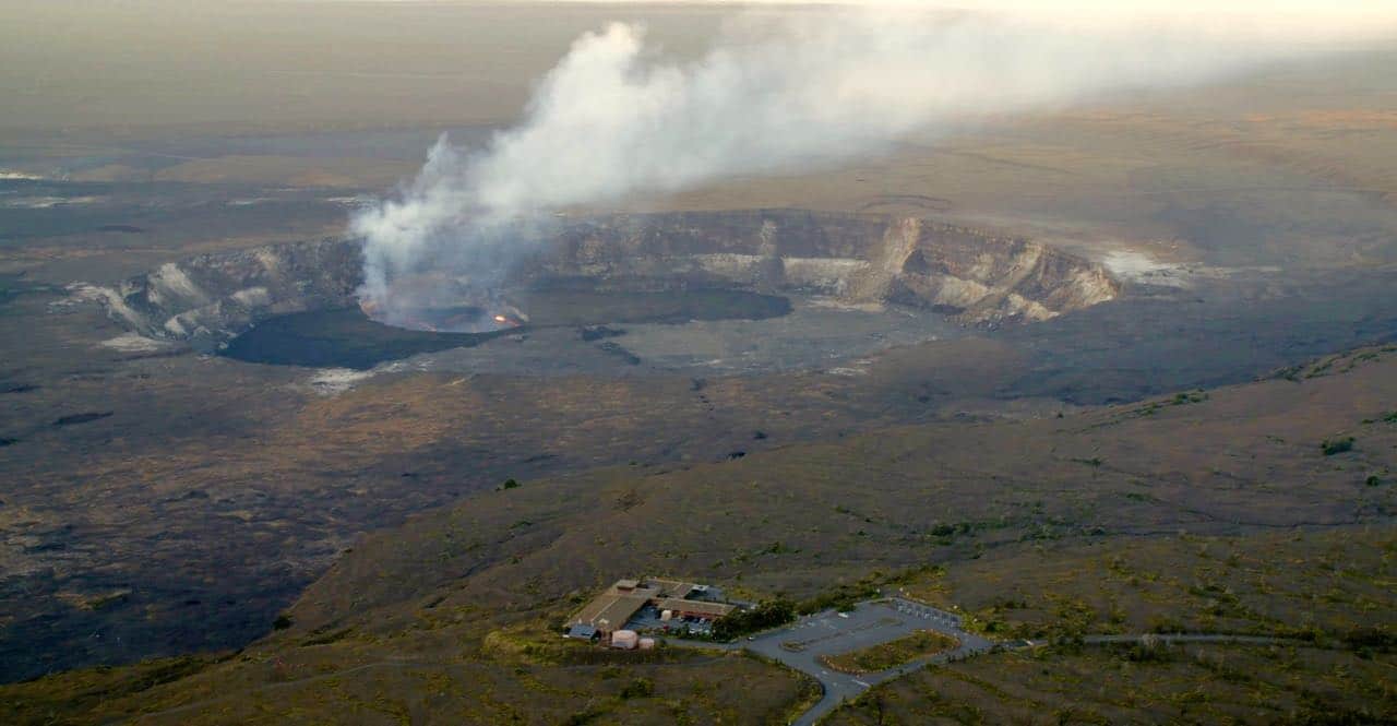
The Lower East Rift Zone continues as usual, more or less. Fissure 8’s fountains remain tucked down in their 180′ cone, sending a river towards Kapoho. However, yesterday’s thermal map shows “the channel flow seems to stall about 2km (1.2 mi) inland of the coast.” Instead of entering the ocean from the channel, it’s oozing out here and there along a wide span of the delta, mostly on the north side. Also, lava is oozing out on both sides of the main a’a field, to the north (still menacing the narrow remnants of Kapoho Beach Lots, and it looks like it’s made a bit of a surface flow there) and southwest.
Fissure 22 is weakly spattering. And as of 9pm HST, we’re still waiting for today’s collapse event at the summit.
Apart from the weather, today was a slow news day for Kilauea watchers. So it’s a good time to catch up on this week’s Volcano Watch, HVO’s weekly column:
Between computer troubles (fixed now!) and that all-important Volcano Village meeting last Thursday evening, I missed the July 5 11am USGS media conference call. Here’s the archived audio file.
It was short, but for completeness’ sake, here’s a transcript.
[Note: Posted July 9, 3.30pm HST, backdated to keep it in correct order chronologically.]
July 3, 2018. USGS: “Fissure 8 and the upper lava channel, viewed from the early morning helicopter overflight of the lower East Rift Zone. Recent heavy rains have soaked into the still-warm tephra and the moisture rises as steam (right side of lava channel).” (Full-sized)
Today’s Eruption Summary
Kilauea’s double eruption continues with little change, except for a few more spillovers. Fissure 8 is feeding its lava river, which continues to ooze out along a broad front on the northern side of the delta and into Kapoho Beach Lots. Fissure 22 continues to spatter intermittently and send out a less-than-impressive flow.
About a dozen Kapoho homes have succumbed to lava over the past week, and more are expected to go. The National Weather Service also reports that there were about 1,200 lightning strikes between 7am and 2pm yesterday during Monday’s lava-boosted thunderstorm in Lower Puna.
Today’s summit explosion occurred at 2:17am HST, with enough clouds that radar couldn’t find a plume (if any). Just to prove seismometers aren’t stuck, the magnitude registered as 5.1. Seismicity is back up to 20-30 quakes per hour after the lull.
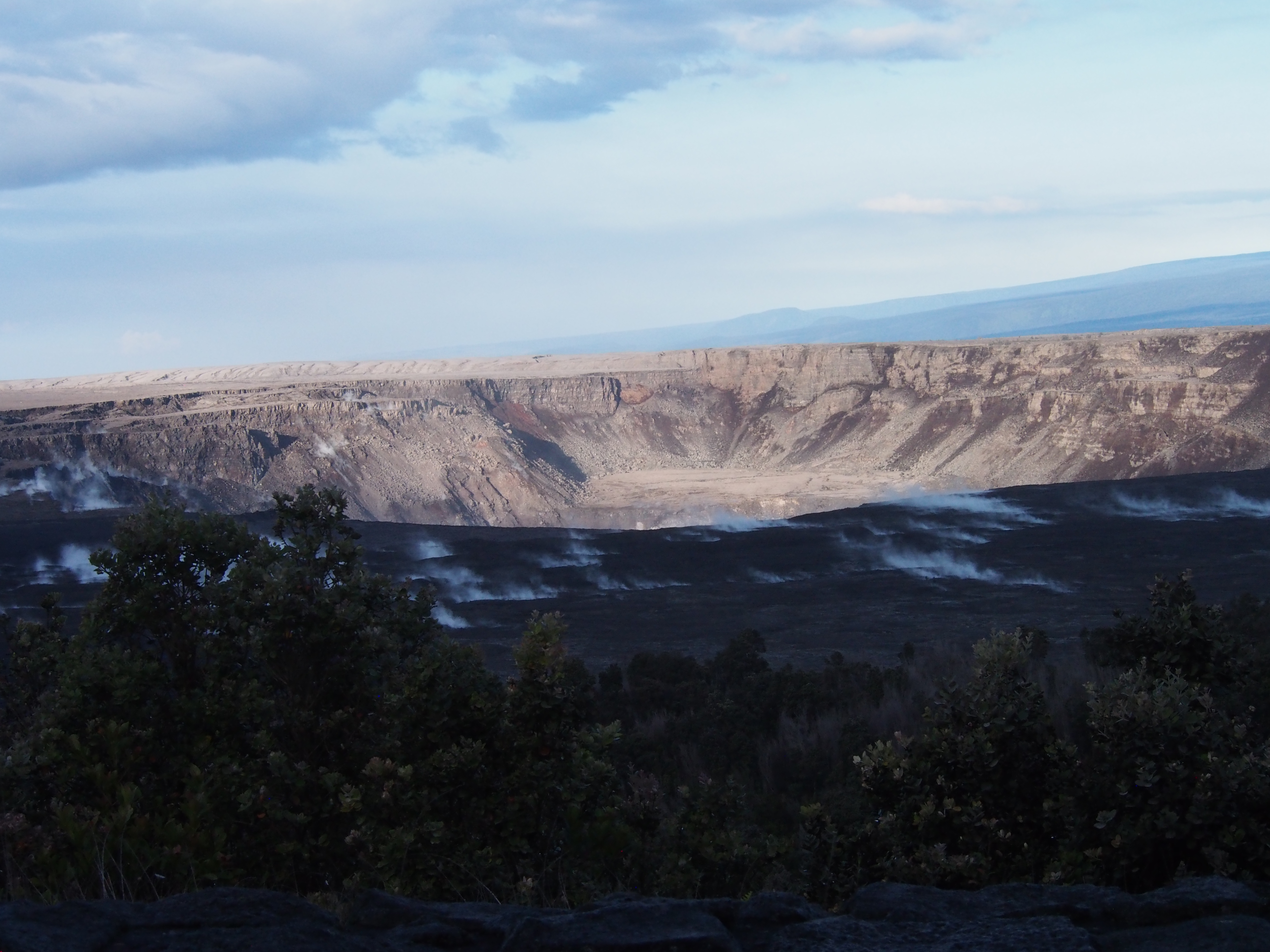
July 3, 2018. USGS: “Inward slumping of Halema‘uma‘u continues in response to ongoing subsidence at Kīlauea Volcano’s summit. This image, taken from a temporary observation post located at Volcano House, shows steep walls on the western side of the crater and sloping piles of rubble from rockfall events.” (Full-sized)
Not to be superstitious or anything, but geologists need to stop giving Pele ideas. During yesterday’s media conference call, Mike Zoellner said, “They [lava boats] do present a risk, because if the flow of the channel jams them against the side and it contacts the levee, that disrupts the flow of the channel. It could divert either the flow itself or the lava going around the boat out of the channel.”
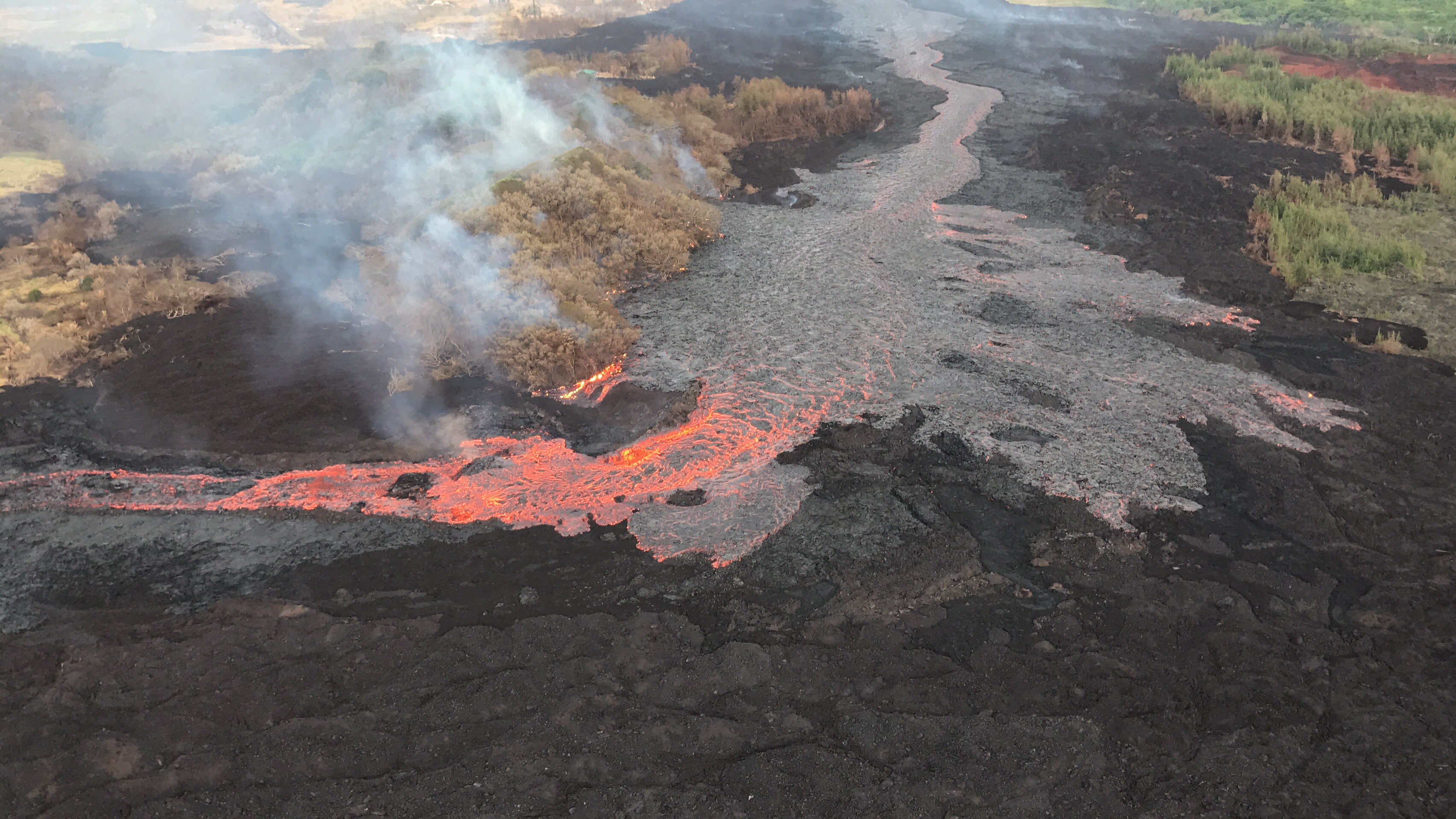
July 3, 2018. USGS: “Evolution of a blocked channel, photo 1. A blockage of rafted material within the lava channel causes lava to flow over its banks near the Kapoho cone. In this section of the lava channel a cold lava flow from the 1960 eruption forms a barrier on the north side, which initially directed the channel to the southeast. A constriction in the channel formed at the bend where chunks of cooled rafted lava were able to accumulate and block the flow.” (Full-sized)July 3, 2018. USGS: ” Evolution of a blocked channel, image 2: While observing this area of the fissure 8 lava channel near Kapoho cone during the morning overflight, geologists witnesed an “apartment-building-sized” blockage within the channel give way and be pushed down stream by the pressurized lava behind. The dark portion within the red channel is the freed blockage. Lava continues to overflow behind the bend and form a cooled black crust. The more quickly flowing lava at the bend has very little crust.” (Full-sized)
See below for a few more photos of this from the Hawai’i County Fire Department.
This continues my transcription of the Thurs Jun 28 USGS presentation at Volcano Village. Part 1 transcribed HVO Scientist-in-Charge Tina Neal and seismologist Kyle Anderson’s remarks. Part 2 covers senior volcanologist and my longtime hero Don Swanson’s remarks.
Here’s the video of the entire 1.5 hour meeting. Don’s presentation starts at 15:50:
It sounds like Swanson’s been holed up in Volcano House after HVO was evacuated. (Kyle Anderson: “Don has spent more time viewing this eruption from the summit than anyone else.”)
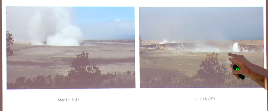
Title of talk: “Comparisons of Halemaʻumaʻu Crater, May 19 through June 28 Viewed from dining room table of Volcano House”
The data that Kyle showed are absolutely magnificent. What I want to do now is to show you some photographs of features that I’ve been able to see during my observations. The first will be a series of photographs of Halemaʻumaʻu taken from the seat in the dining room of the Volcano House hotel where I sit and observe things.
Screencap of first slide in Don Swanson’s presentation. In USGS archives: [May 19] [June 13]On May 19th, of course, things were just starting to get going, but over here on June 13th, you can see that the crater has widened dramatically, and notice that it’s also dropped to the top of the tree which was way below the— it’s come way down. It isn’t because the tree is growing! It’s because the crater is dropping down.
Now we’ll go to this next period, June 13th to the 17th.
On Thursday, there was an hour and a half meeting with the USGS, National Park Service and residents of Volcano Village. Above is a video of the whole meeting. As usual, I’m interested in the geology, and so I’ve made a transcript of that part of the meeting. The first half of Kyle Anderson’s talk rehashes the “collapse/explosion” events that we’ve covered before, but the second half has a timelapse of Halema’uma’u from June 1st to June 28th — which I’ve rebuilt frame by frame, since I could just make out the timestamps— plus the latest Digital Elevation Model of Kilauea’s summit showing the slumping not only in Halema’uma’u, but across part of the caldera floor.
Scientist-in-Charge Tina Neal (HVO)
[5:40] [Introductory remarks, greetings and thanks]
[6:20] So tonight you’ll hear from familiar faces, Kyle Anderson and Don Swanson, who will give you an update on what the volcano is doing, what we think is happening, and we’ll touch on this very important question of how long and how big. Those are very hard questions to answer, so let me just preview that we’re not going to give you a wonderful take-away that will solve all that uncertainty. But we’ll do the best we can.
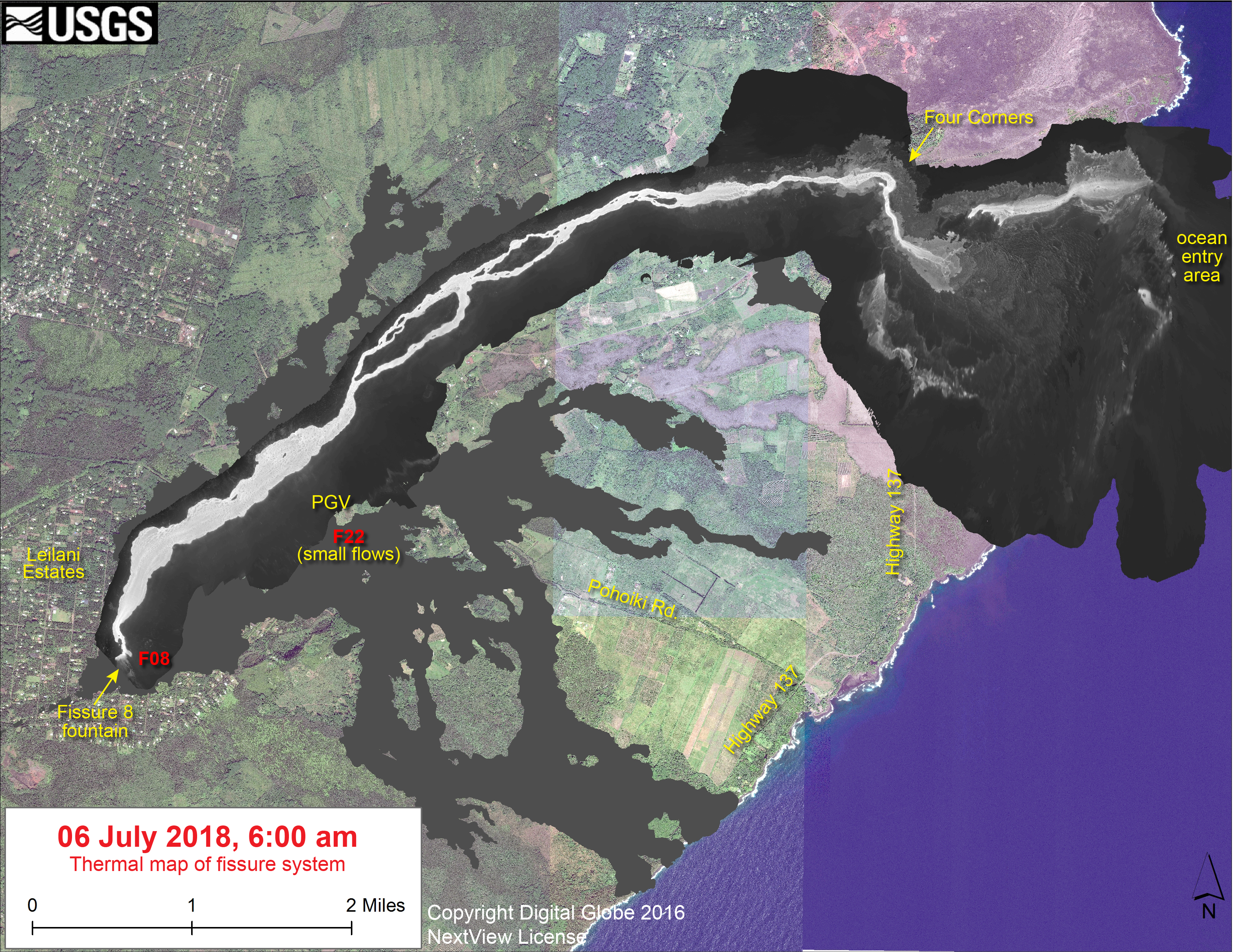
Fissure 8 and the summit explosions continue their status quo. However, for the last few days, the lava flow at Kapoho has been encroaching on new areas on its northern and southern boundaries at the coast.
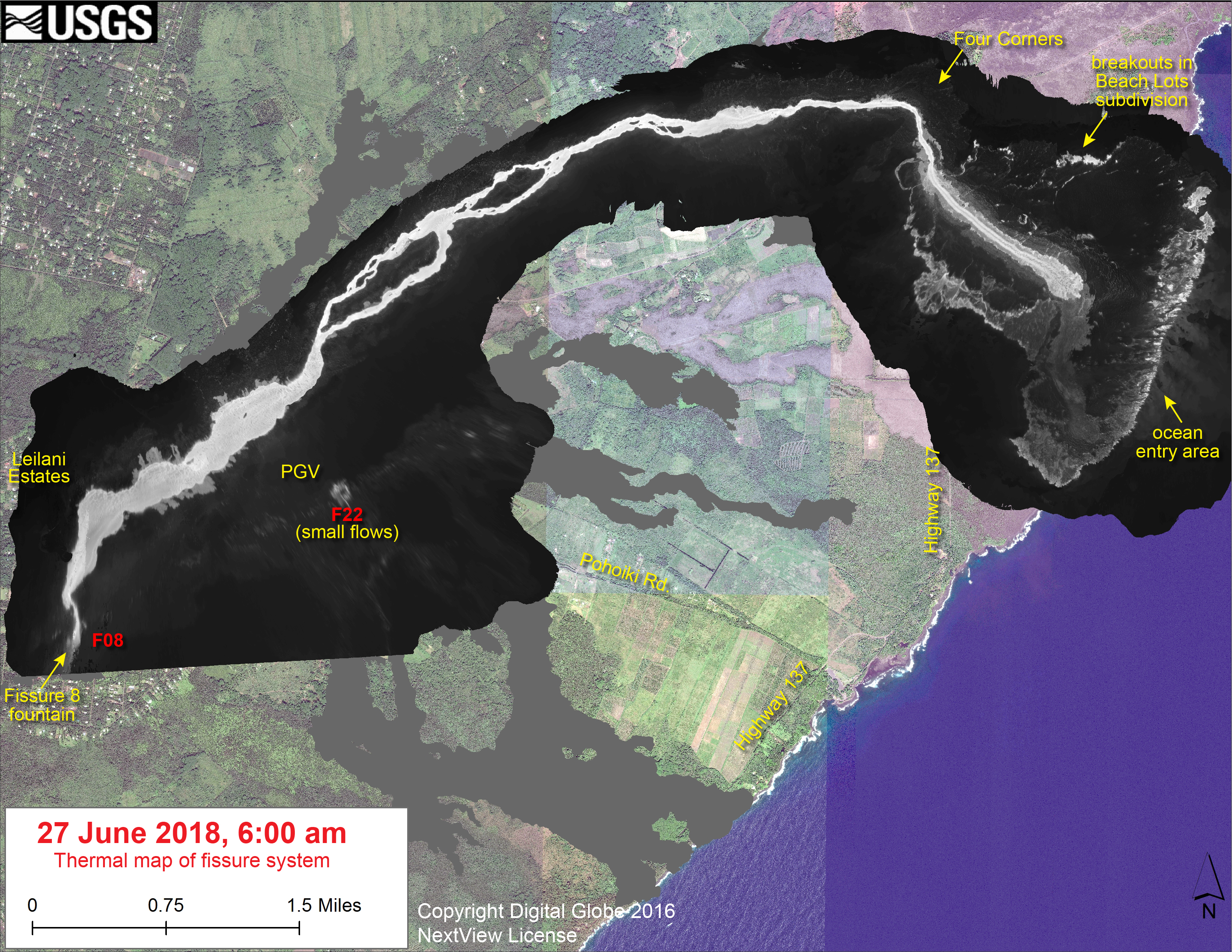
At least 3 more Kapoho Beach Lot houses have burned on the north side, and the southern edge of the flow is burning vegetation and/or farmland west of Highway 137. I gather these new lateral outbreaks are due to the lava channel crusting over, about half a mile inland from the new coastline (see Wednesday’s thermal map). So instead of pouring straight from the channel into the ocean, lava is fanning out under the crust of the 2-mile-wide lava delta laid down earlier this month, then oozing out the sides.
[USGS drone footage of Fissure 8 from before dawn. They’re using drones for the first time to map flows, look for outbreaks and measure the lava river’s speed.]
At Kilauea’s summit, today’s collapse explosion occurred at 7:51am HST, June 29, with an ash-poor steam plume that rose 500 feet. (Steam?)The energy release dropped slightly to 5.2. I didn’t do a video capture, since the summit was blanketed in morning fog.
The “new news” today is that HVO has added two new views to its Kilauea Webcams page. One I’ve mentioned before, the old “Kilauea East” webcam from HVO’s 1990s website which has annoying reflections but a great view of the subsidence/collapse on the east side of Halema’uma’u Crater:
June 25, 2018 screengrab from “Kilauea East” webcam.
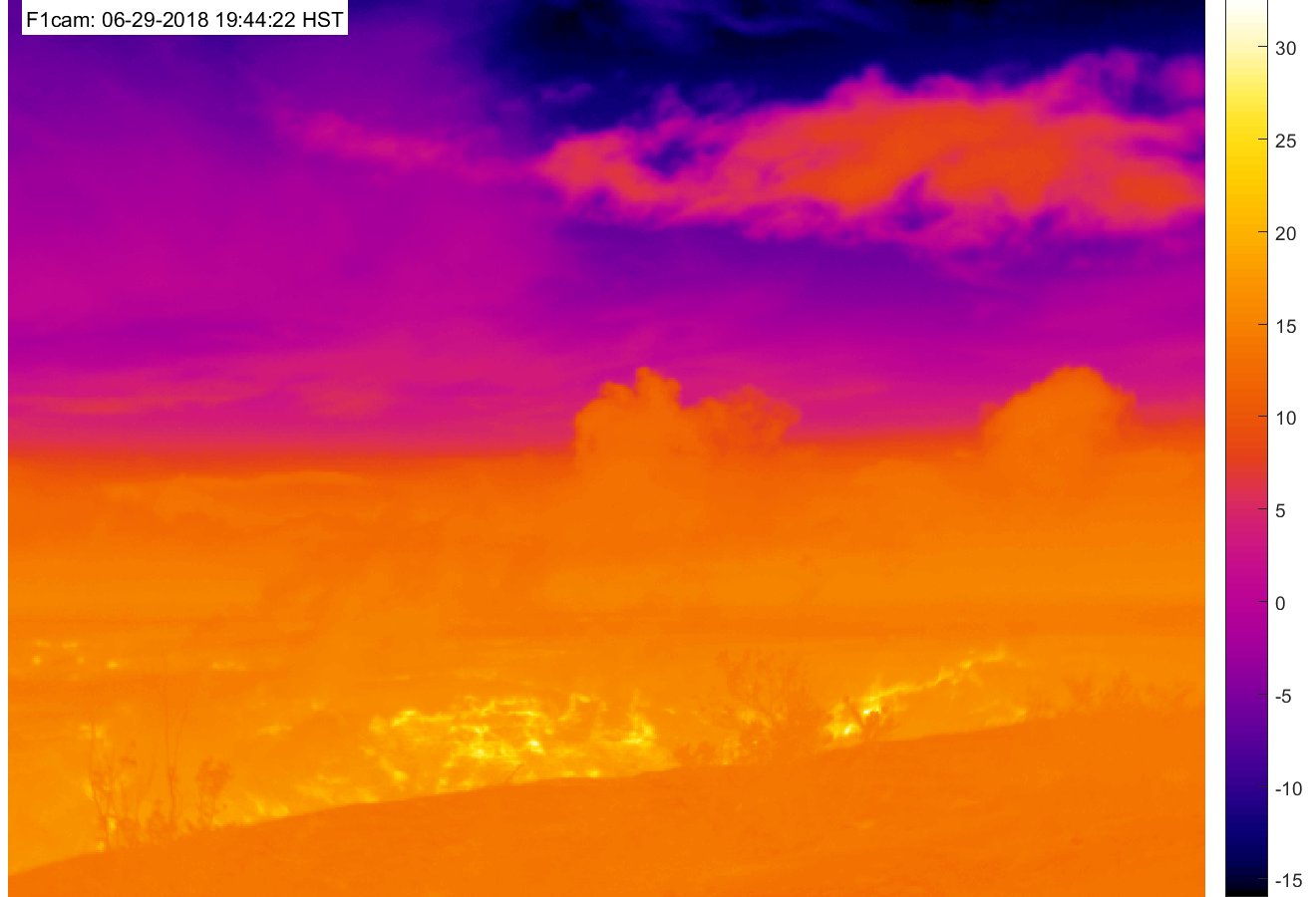
The other is a new heat-sensitive webcam which should make it possible to see “collapse explosions” at night:
Also, in this week’s “Volcano Watch” newsletter, Hawaiian Volcano Observatory scientists explain the “piston” model they’ve developed to account for the daily collapse explosions at the summit:
This is big news. They’ve solved the mystery of the summit explosions! Subject to revision, of course; they’re still untangling the complexities of Kilauea’s current eruption. But the “piston” model accounts for the cyclical pattern they’re seeing better than the “steam explosion” model.
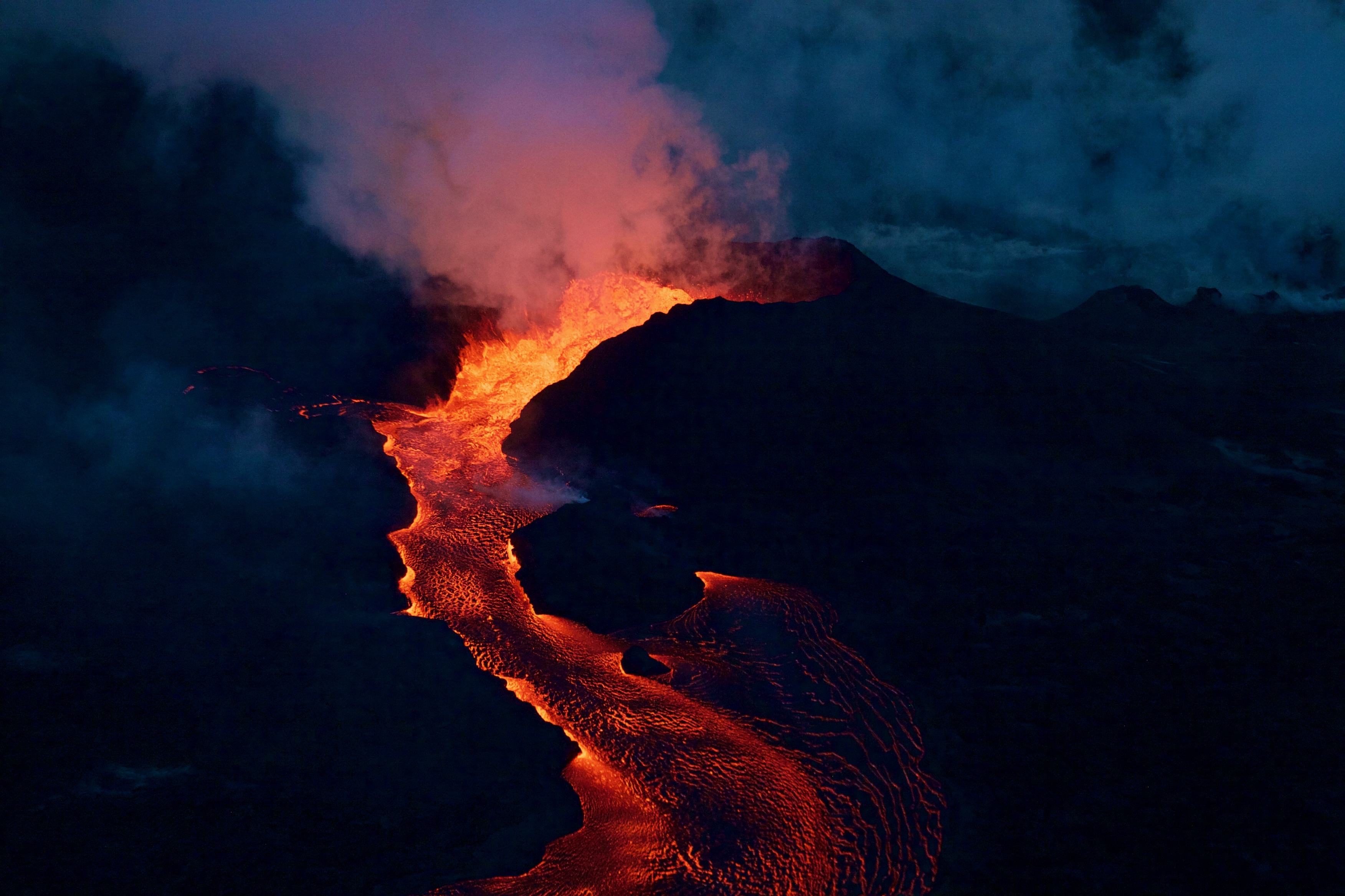
Exactly 8 weeks after the Lower East Rift Zone eruption began in Leilani Estates on May 3, Fissure 8 continues to gush unabated. Its fountains are contained within its 55-meter (180 ft) cone, and this morning’s overflight showed no active overflows.
For the past day or so, the lava river has crusted over on the last half mile to the ocean. This has allowed lava seeps, described by Steve Brantley in his Tuesday evening talk, to creep into still-molten earlier flows on the northern side of the lava delta. This “lava seepage” is oozing into the ocean along a broad front, encroaching onto what’s left of Kapoho Beach Lots on the northern edge of the flow:
USGS: “View of the ocean entry (lower left) from this morning’s overflight. Lava was entering the ocean across a broad area primarily on the north part of the lava delta. Upslope along the northern margin of the flow field, lava is still oozing from several points in the area of Kapoho Beach Lots. Fissure 8 lava fountain in the upper left. Note southward bend in the lava channel around Kapoho Crater.” (Full-sized)
At Kilauea’s summit, the most recent collapse explosion occurred at 4:49am this morning, sending up an ash-poor plume about 1000 feet, with the energy release of a 5.3 earthquake. The sides of Halema’uma’u continue to collapse inward and downwards, especially during each explosive event.
Increased seismicity in the hours leading up to each explosion, up to 25-35 small earthquakes an hour, is wearing on the nerves of nearby Volcano Village. The USGS is meeting with them tonight to talk about the ongoing earthquakes, and released an excellent FAQ today: “Frequently Asked Questions About Kilauea Volcano’s Summit Earthquakes.”
Local News Outlets Given Brief Tour of Summit
The big news today is that the National Park Service and USGS arranged a brief escorted tour for local news media to the rim of Kilauea Caldera, which has been closed to visitors for 49 days. There was also a half hour press briefing.
So today there’s suddenly a lot more videos and views of what the caldera looks like:
In fact, I’m going to put the news media links before the science segment of today’s post. Boldfaced articles include quotes, videos, and/or photos from the media summit tour.
On June 26, 2018, Deputy Scientist-in-Chief of the Hawaii Volcano Observatory, Steve Brantley, gave a ten-minute slideshow at the Puna Community Meeting in Pahoa. Video of the meeting is posted here. Steve Brantley’s talk starts at 35:00 in that video.
BigIslandVideoNews excerpted half of his talk in this video, which they overlaid with footage from a June 24 USGS drone overflight of the summit:
Below is my transcript of the complete talk, including images that match or approximate his slides.
Steve Brantley (USGS):
Hello, everybody. Thank you for coming out.
I’ll just describe a few things occurring in the Lower East Rift Zone and then summarize the activity up at the summit at the very end.
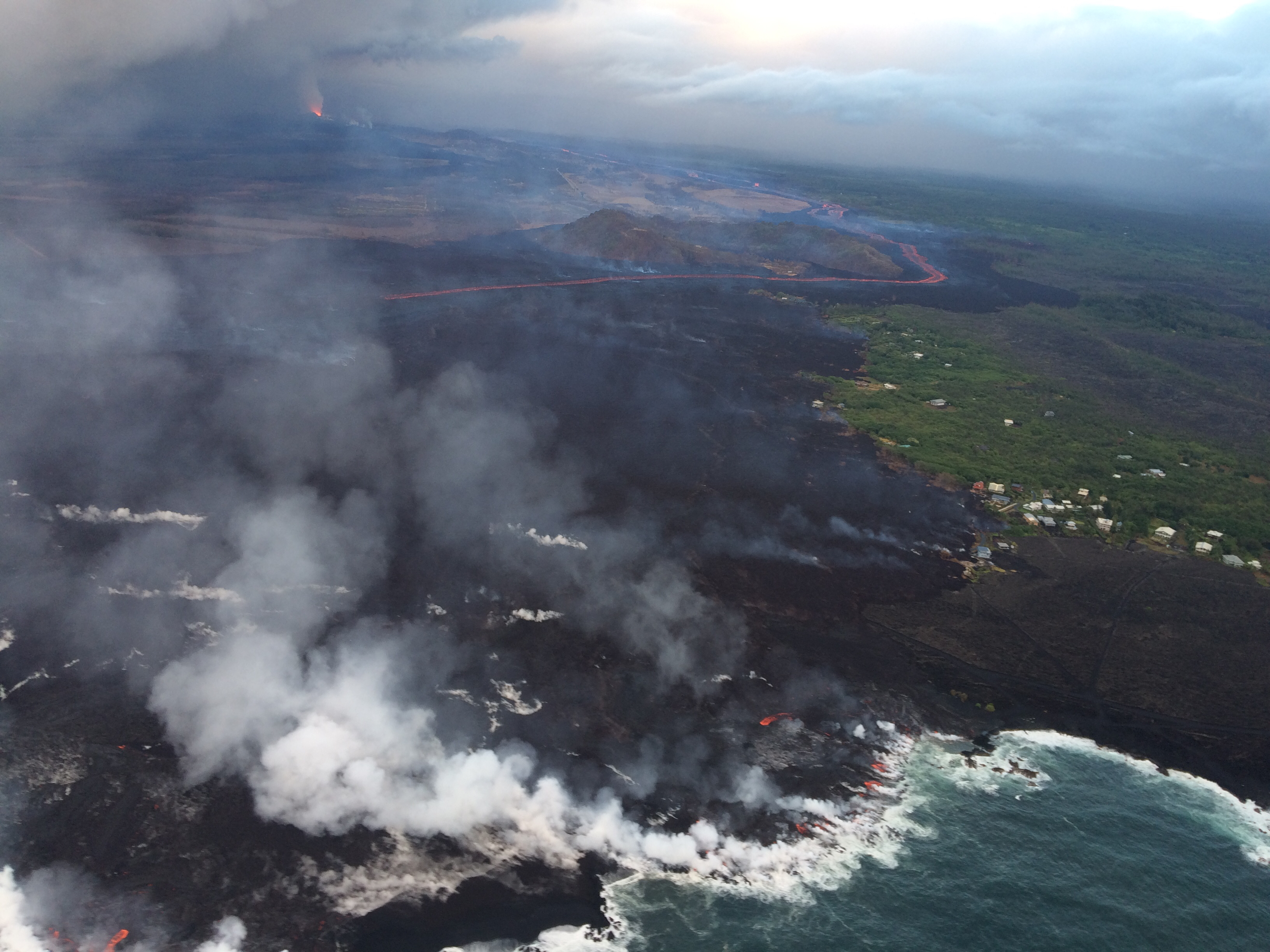
Kilauea’s double eruption continues with no significant changes: Fissure 8 is still pumping out lava, and the summit is continuing to settle. The ocean entry has expanded to two miles wide, with its southern edge creeping south just onshore.
Here’s a timelapse of all the USGS lava flow maps since lava started moving away from fissures in May:
Fissure 22 is sputtering and sending out tepid little lava flows that don’t go anywhere, while Fissures 16/18 were “incandescent” during the morning overflight.
June 26th’s collapse explosion waited a full 29+ hours, just to keep us on our toes, occurring at 10:41pm HST. The energy release was 5.4 with a 1000-foot ash plume.
Yesterday’s Mick Kalber Overflight:
While the daily collapse explosions at Kilauea’s summit haven’t sent up much ash lately, they’re still giving off a voggy burp of sulfur dioxide. And some of the ash that fell earlier is still blowing around and irritating communities at the southwest end of the island:
USGS: “Recent explosive events haven’t produced significant ash plumes from the summit, but downwind communities may still experience ashfall when previously erupted ash is remobilized. On authorized permission from Hawai‘i Volcanoes National Park, our Unmanned Aircraft Systems crew is conducting gas measurements at Pu‘u ‘Ō‘ō. They snapped this photograph from Chain of Craters Road – a plume of remobilized ash is clearly visible along the horizon. It is rising from the Ka‘ū Desert and blowing to the southwest.” (Full-sized)
The big news today is that the USGS posted new drone footage of Halema’uma’u Crater.
Full video below. If you want extra drama, here’s a version with a soundtrack added.
HVO/Jaggar Museum are the low dun-colored buildings (same color as the bluff they’re sitting on, well-camouflaged) swing into view at the top of the screen around 2:30 and are middle of screen at 2:40 just before it shifts to a new view. (The larger, more conspicuous buildings near the beginning of the video are the old Kilauea Military Camp and the Volcano Golf Country Club).
Here’s an aerial photo of Halema’uma’u from April 13, 2018 for comparison, with Jaggar Museum/HVO at the top of those stairstep bluffs in the background, middle right. Here’s another view of the two buildings.
Fissure 8 is status quo. Today’s HVO Kiluaea status report says its cone is now 180feet tall. Its flow front has broadened southwards, widening to two miles, moving south on shore as well as continuing to expand offshore (lava delta acreage: ~405). The main channel/ocean entry remains on the southern side of the front, with minor entries in a 1-kilometer zone.
The lava Fissure 22 is weakly active; no activity observed at 16/18.
USGS: “This animated gif shows the fissure 8 tephra (cinder and spatter) cone morphology changes between June 15 and 24, 2018. During this time a shoulder grew on the channel side of the cone as the vent shifted from being two distinct fountains to three, then to a single source of voluminous roiling. The cone height is about 47 m (154 ft) from the hardened lava surface on which it was built.” Note: This isn’t a webcam but a temporary camera they set up; they have to download pictures manually. (Full-sized)
According to Mike Zoeller (UHI) at today’s 11AM conference call, the lava delta is advancing at less than 50m/day; it was 200/day a week ago. The southern edge of the flow is a kilometer from Ahalanui Beach Park. Over the weekend, he observed top lava speeds of 25kph (15.5mph); Leslie Gordon (USGS) saw it max out at 35kph (21.75mph) last Friday night.
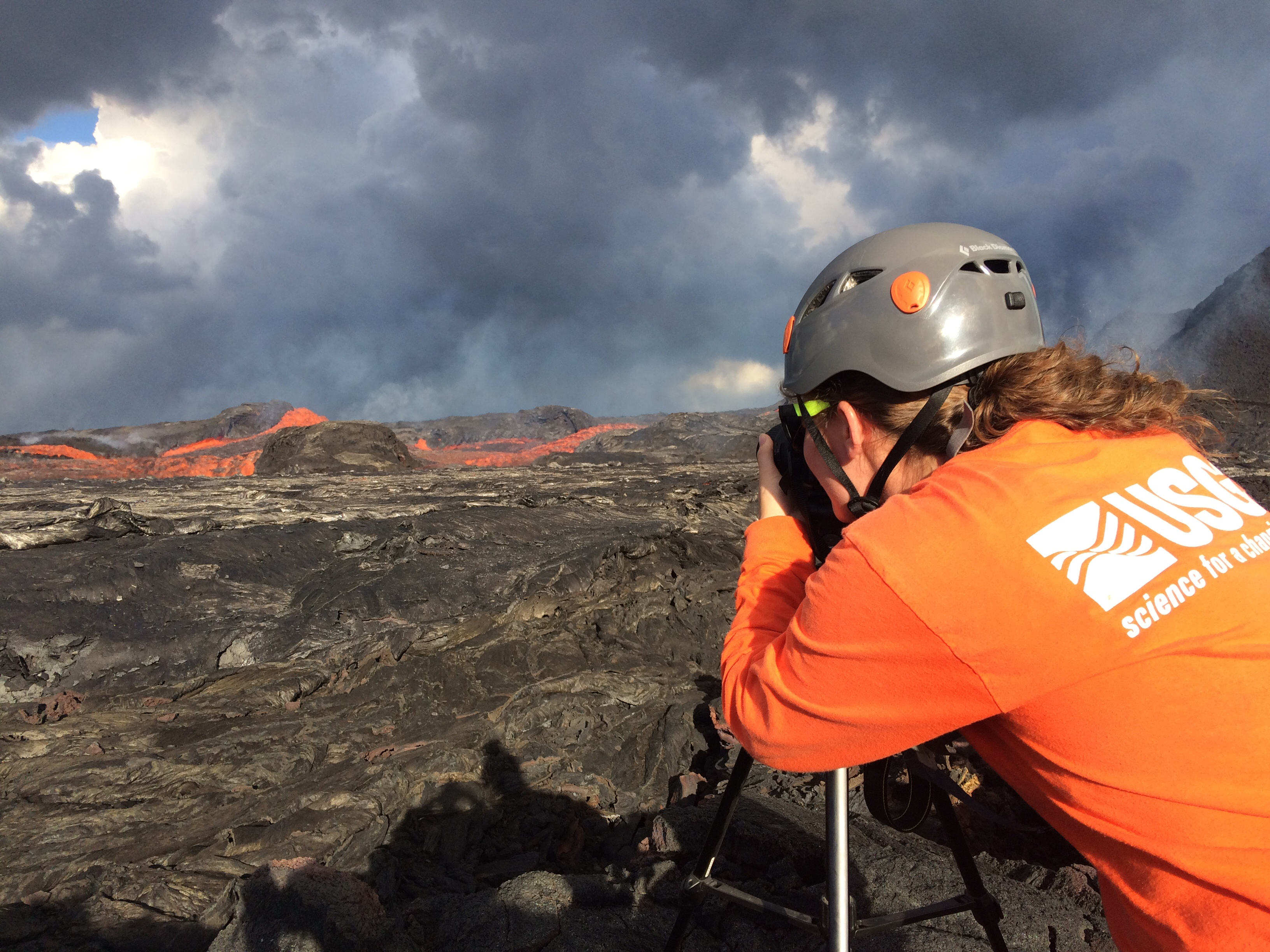
USGS: “USGS Hawaiian Volcano Observatory geology field crews maintain watch over the eruptive activity in the lower East Rift Zone and at Kīlauea’s summit. Here, a geologist documents the behavior of lava as it exits the Fissure 8 cone. Lava enters the upper channel traveling as fast as 30 km/hour (18 mi/hour).” (Full-sized)
After yesterday’s collapse explosion at 4:12, seismicity dropped from a high of 25-35 quakes an hour down to less than 10, but had started to creep up again and was averaging 30 by dawn. On the livestream, I observed clouds of ash/dust in the crater’s interior at various times during the day. Today’s collapse explosion occurred at 5:03pm, equivalent of a 5.3, ash-poor plume rising less than 2000 feet.
Jun 24: chasing rainbows and lava with Mick Kalber. He was checking on a lava spillover uncomfortably near his house! (Helicopter noise)
Reminder: HVO downgraded Kilauea’s aviation alert to ORANGE last night, because ash explosions have rarely risen above 10,000 feet since May.


