June 18: Harry Kim Needs to Rest

Today’s Eruption Summary
USGS gif of F8 lava flow  Jun 17.

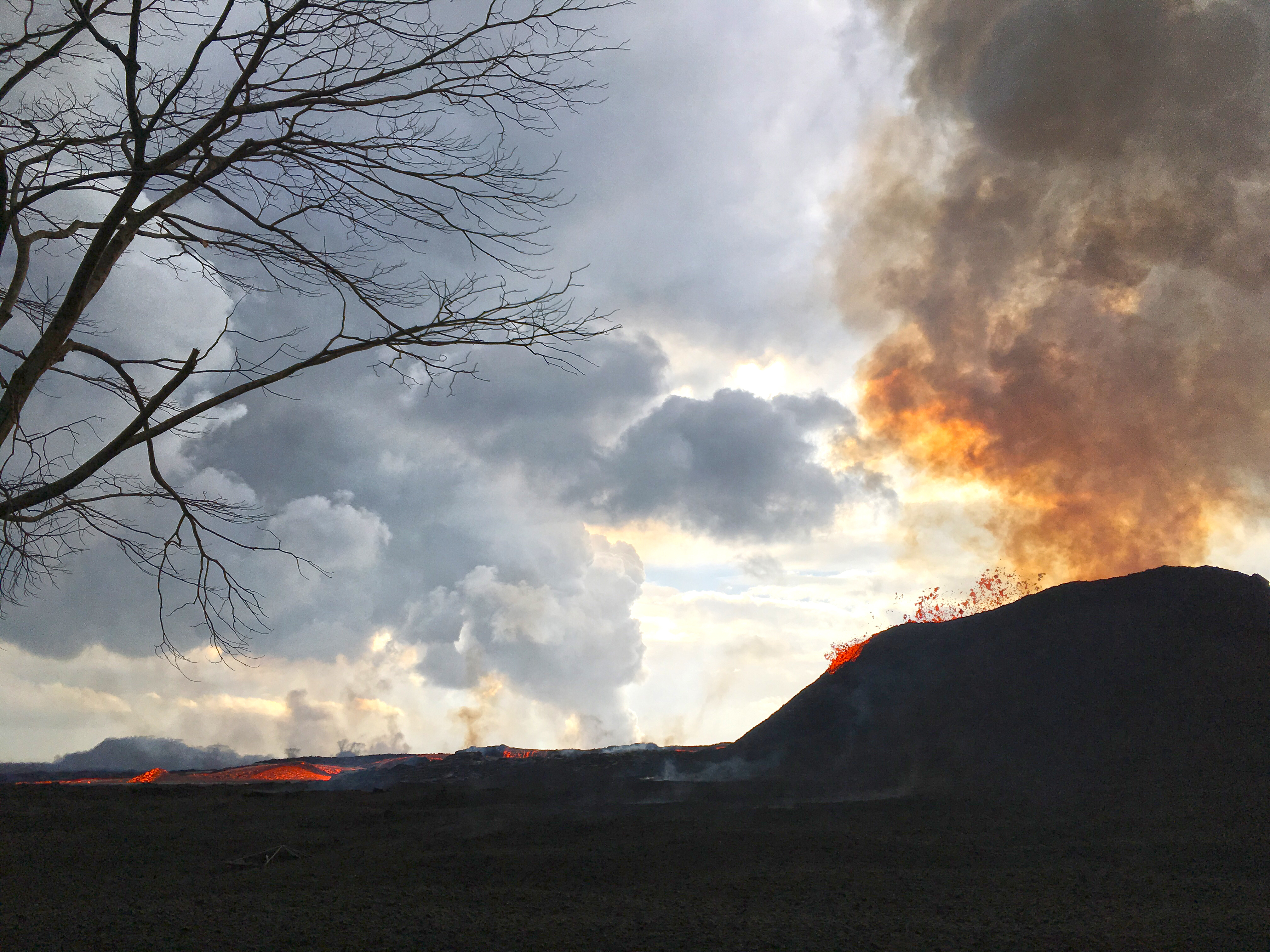
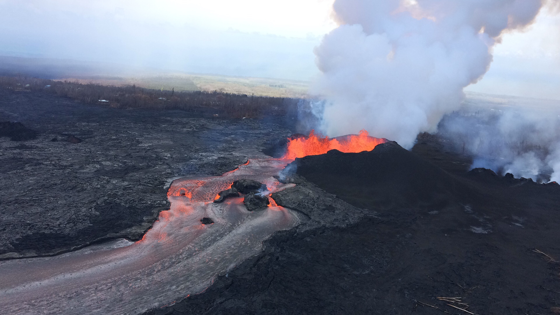
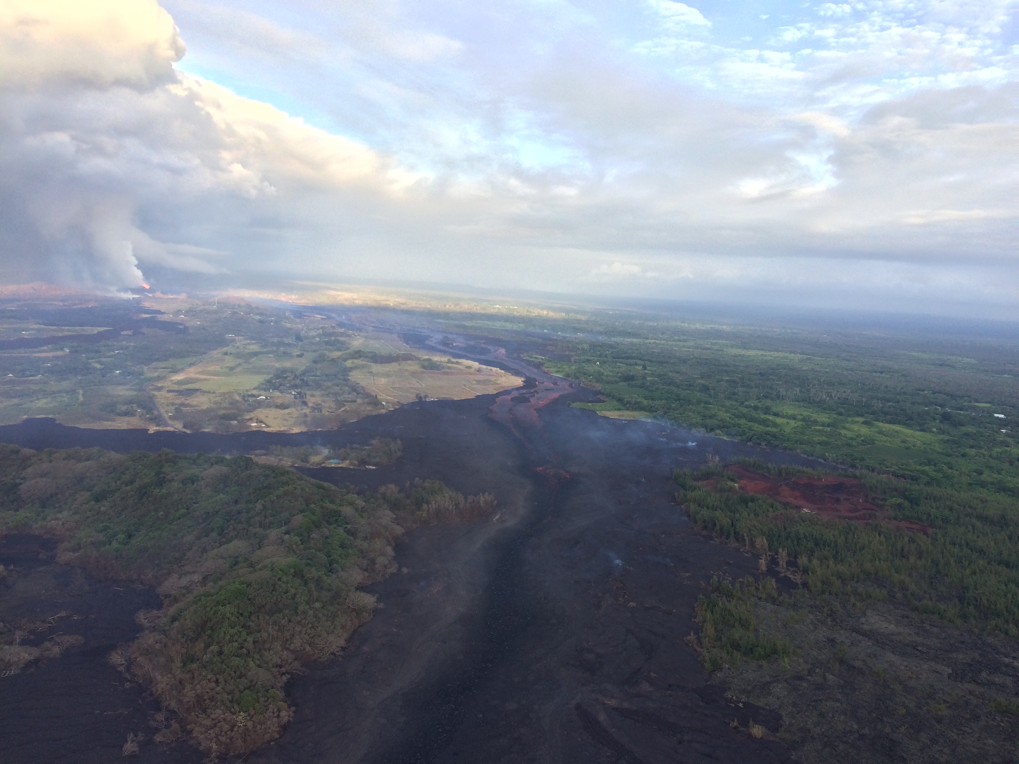
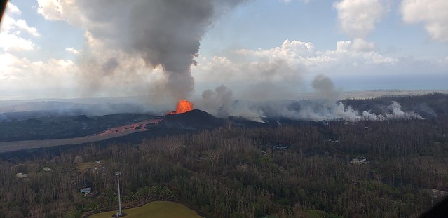
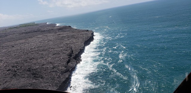
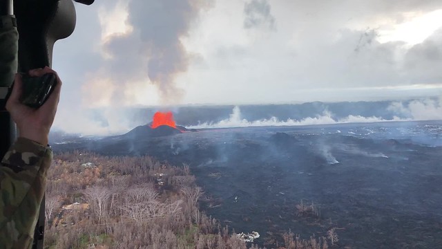
Fissure 8’s still doing its thing, fountaining 150-180 feet overnight with 164 foot spatter cone. The usual minor spillovers on the channel to the ocean. Today the lava’s entering the ocean mostly on the south side of the lava delta in the vicinity of Vacationland. Fissure 16/18 are still oozing, and fissure 6 (the bright spot to the left of Fissure 8 on the LERZ webcam at night) is intermittently incandescent or spattering. Both are “forming small lava flows on top of the existing flows.

USGS on Facebook: “About midday, minor amounts of lava spilled over the channel levees but did not advance very far. USGS image taken June 18, 2018 of the upper flow field, just downstream from fissure 8. The ocean entry is marked by a visible plume in the upper left.”

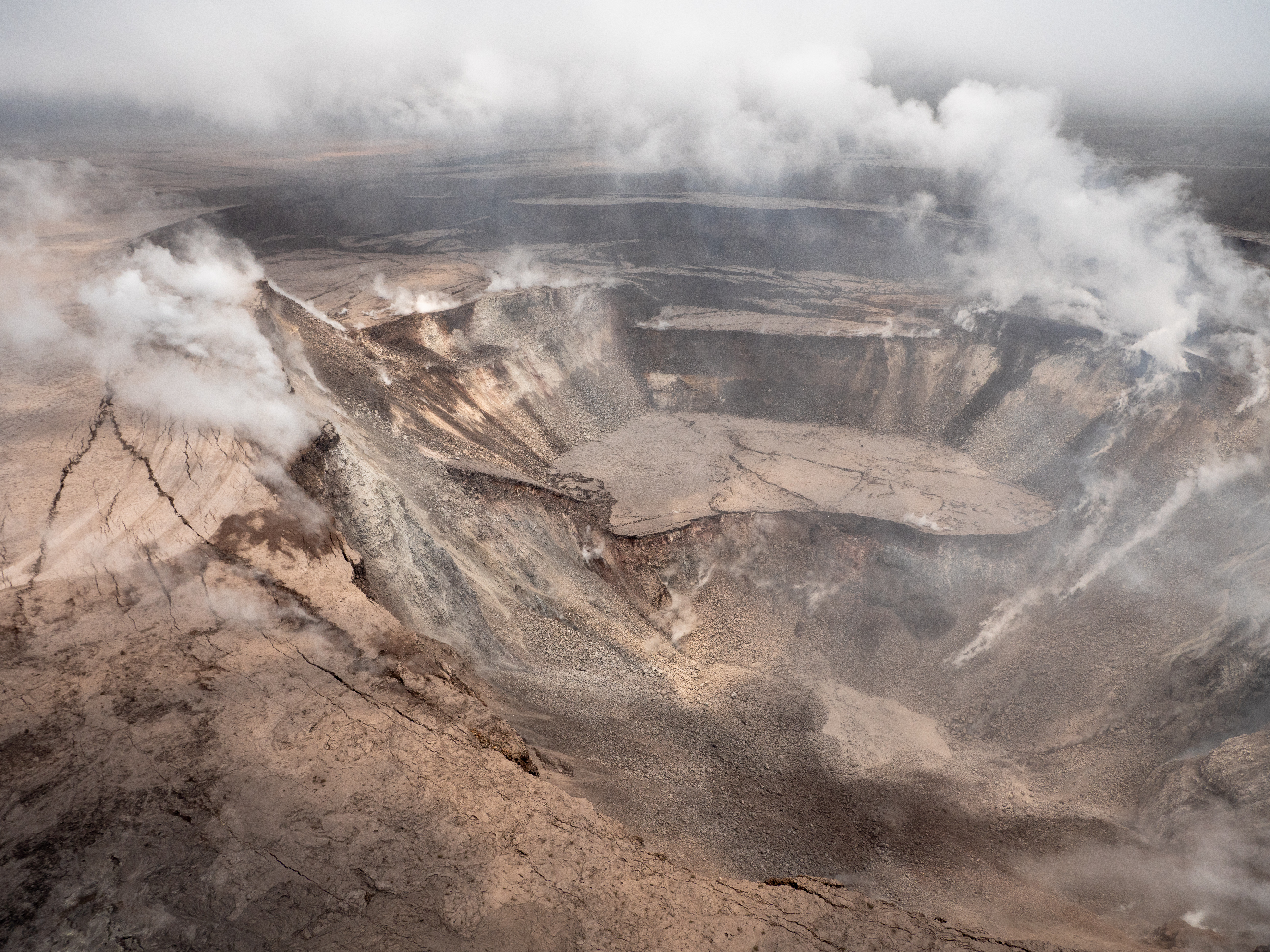
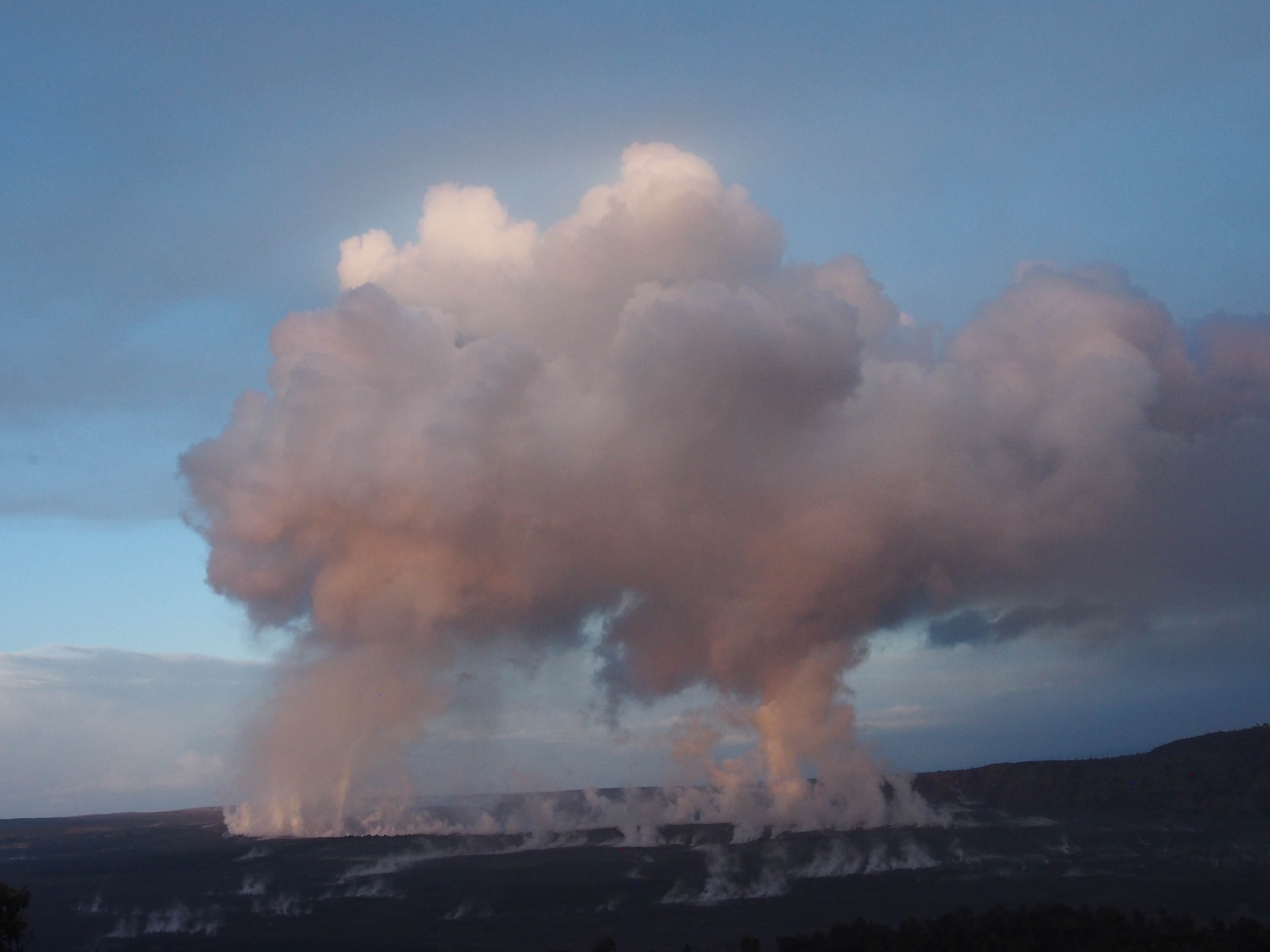
The summit’s daily explosion occurred at 6:12 am, moment magnitude 5.3. It produced a “very small, minor plume that went no more than 500 meters above the ground.” (Brian Shiro in 11AM conference call):

I rewound the Kilauea livestream to watch. The crater was steaming with small white puffy clouds of morning condensation. I saw the window frame vibrate, but the short-lived plume of ash/steam obscured the crater rim, so I didn’t spot any downdrops or rockfalls like we’ve seen for the past few days.

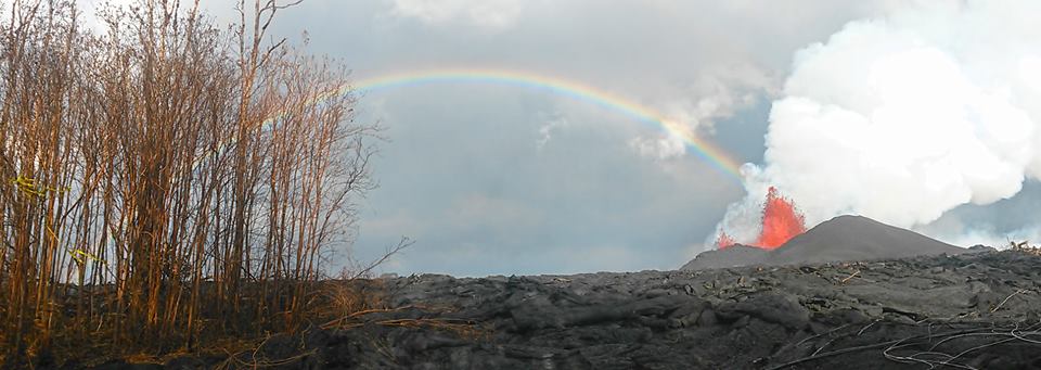
Below: Lots of great photos of summit and LERZ lava field today, and excellent Q&As from USGS on social media.

Continue reading June 18: Harry Kim Needs to Rest

June 14: The Face of Pele

Let me pause my science-blogging for a moment and direct your attention to a very special visitor in yesterday’s Tropical Visions overflight video.

About timestamp 0:30 in June 13 overflight video, Madame Pele’s profile appears in the partly-cooled lava. Mahalo to Tutu Pele, to Mick Kalber for his tireless aerial videography, and to my mother for pointing her out to me. [Although it sounds like Mick took the day off, and I should thank Mick’s co-photographer lavajavadude.]
Respect.

Now, how do I transition from that back to the science side of Kilauea?

Today’s Eruption Summary

Last night and today, Fissure 8’s fountains have rebounded to 200 feet, but the cinder/spatter cone they’ve built is so tall they’re just peeking out:

USGS: “The Fissure 8 viewed from the north at 7:50 AM. The cone is roughly 50 m (165 ft) high at is peak, and a plume of sulfur dioxide and other volcanic gases rises as an orange tinge from the erupting lava fountains (hidden within the cone). Lava is still flowing out of the vent unabated as a full channel. To the left of the cone, a standing wave of lava can be seen in the channel.” (Full-sized)

Fissures 16 and 17 continue to “ooze,” to borrow the USGS’ technical term.

Fissure 8’s lava river remains fast, wide and healthy. It stays incandescent red rather than skimmed over for many miles, which shows just how hot and voluminous it is (26,000 gallons/second). It’s entering the ocean along a dramatically broad front (second half of video clip):

Today’s summit explosion (energy equivalent of M5.3, like clockwork) occurred at 3:19am HST, with an ash plume to 6,000 feet. Again, there were lots of earthquakes in the hours leading up to it, then they dropped off, and now they’re ramping back up to the next explosion. This pattern must be getting pretty old for the nearby residents of Volcano.

After the cut:

USGS info on the ongoing eruption, timelapses of recent changes at the summit, Kilauea-related news, and more stunning photos.

Continue reading June 14: The Face of Pele

June 13: Towering Laze, Big Hole in the Ground

Today’s eruption summary:

Lower East Rift Zone: Fissure 8 continues to build its oblong cinder and spatter cone. Overnight fountain heights were 130-140 ft, up to 53m (174ft) by the afternoon. Fissures 16 and 18 continue weak activity.

USGS: “Fissure 8 fountains to heights of 130-140 ft. The lava spatter chills and the fragments are building a cone on the downwind side, now nearly as tall as the fountain itself.” (Full-sized)

Fissure 8’s lava flow had a “towering” steam plume at its ocean entry point this morning. Areas of offshore upwelling have become more dispersed.

6AM overflight of Kapoho, “towering” laze plume at ocean entry of Fissure 8 lava flow. (Full-sized)

The daily summit explosion was at 3:39am, equivalent to M5.4 earthquake, with an ash plume 7-8K feet (NWS radar has been repaired). Slumping and subsidence continue at Halema’uma’u, and SO2 emissions remain about half pre-event levels.

Before and After: Changes at Halema’uma’u

Here’s a good view of Halema’uma’u taken at Hawaii Volcanoes National Park, April 19, 2018 by Christoph Strässler (Creative Commons):

Gorgeous photo of Halema’uma’u Crater and its lava lake, April 19, 2018 by Christoph Strässler (Creative Commons). See his photo album for more images from this visit.

Compare with this animation from HVO webcam June 1-10, or the new drone footage later in this post.

USGS: “A series of wide-angle webcam images, captured by a camera in HVO’s observation tower between June 1 and June 10, 2018, show ongoing subsidence around Halema‘uma‘u at the summit of Kīlauea in this animated GIF.” (Full-sized)

Today’s Kilauea news daily digest is full of science, science, science! the usual slew of incredible pictures. Also, some glimmers of hope for lava evacuees, although as usual bureaucracy moves at the speed of of dirt.

Continue reading June 13: Towering Laze, Big Hole in the Ground

June 12: Halema’uma’u’s Collapse Continues

Summit:  Today’s “Type A” explosion occurred at 1:52am. It produced almost no ash this time, although there’s still light ash and SO2 coming out of the crater from time to time. The view of the continued slumping/subsidence of Halema’uma’u crater is impressive (also see Jun 9 video on Twitter):

USGS: “Events at the summit of Kīlauea over the past few weeks have dramatically reshaped Halema‘uma‘u, shown here in this aerial view, which looks west across the crater. The obvious flat surface (photo center) is the former Halema‘uma‘u crater floor, which has subsided at least 100 m (about 300 ft) during the past couple weeks. Ground cracks circumferential to the crater rim can be seen cutting across the parking lot (left) for the former Halema‘uma‘u visitor overlook (closed since 2008). The deepest part of Halema‘uma‘u (foreground) is now about 300 m (1,000 ft) below the crater rim. The Halema‘uma‘u crater rim and walls continue to slump inward and downward with ongoing subsidence at Kīlauea’s summit.” (Full-sized)

Fissure 8’s cluster of vents is erupting up to 160ft today. With the cinder cone that’s built up around them, they’re mostly hidden. It’s entering the ocean today along a broad front. Fissure 16/18 are spattering weakly; this is the “weak activity” reported for the past few days. Apart from that, the Lower East Rift Zone is quiet, although other fissures are still releasing gasses.

The good news is, Fissure 8’s lava flow has built up such high, broad banks that unless it overflows them, it probably won’t cover many more homes or cut off new areas. The bad news is, the lava river could still break its levees, and there’s no guarantee other fissures won’t reactivate. USGS field crews reported a “non-erupting crack” in the Lower East Rift Zone with “temperatures as high as 430°C (806°F).”

Note, however, high temps may not indicate imminent changes. USGS clarified on Facebook: “This was at Fissure 10, which has long displayed high temperatures (fortunately, no SO2 was detected). It does not mean an eruption there is imminent, but rather it is a place where various superheated gases are escaping.” Similarly, there’s been high temps at the cracks across Highway 130, which have steamed but so far not erupted at all.

USGS overflight photo, morning of June 12. Fissure 8 and Leilani Estates. I think that’s Nohea Street. (Full-sized)

Somewhat abbreviated Daily Digest today because I started late, and then took forever transcribing 11AM conference call. But the stunning pictures keep coming…

Continue reading June 12: Halema’uma’u’s Collapse Continues

June 11: USGS Press Conference (Halema’umau Subsidence, Ocean Upwelling)

At a 3PM press conference, Jim Kauahikaua (USGS geophysicist) described in detail the subsidence at Halema’uma’u. He also talks about a patch of “upwelling” where lava has entered ocean at Kapoho and seems to be traveling along ocean floor, heating water above it.

(Transcript below the cut)

Continue reading June 11: USGS Press Conference (Halema’umau Subsidence, Ocean Upwelling)

June 11: Summit Hiccups, Ocean Entry Upwelling

Fissure8’s “three closely space fountains” are starting to climb down, reported at 115-130 feet last night, and “fluctuating heights from below the 115 ft high spatter cone around it up to 180 feet” this afternoon. But its lava flow is still full to its banks, entering the ocean in Kapoho with minor steam explosions. “Weak lava activity” was spotted at fissure 16/18 last night.

USGS: “The three closely spaced lava fountains at fissure 8 reached maximum heights of 115-130 feet overnight. Lava fragments falling from the fountains are building a cinder-and-spatter cone around the erupting vent, with the bulk of the fragments falling on the downwind side of the cone. Fissure 8 continues to feed a channelized lava flow that reaches the ocean at Kapoho.” (Full-sized)

Last night, Kilauea’s summit hiccuped: there was a small explosion at 12:46am, after which, seismicity did not drop off until after another, larger explosion at 4:43am like the ones we’ve seen lately (registered as M5.4).

USGS: “A series of wide-angle webcam images, captured by a camera in HVO’s observation tower between June 1 and June 10, 2018, show ongoing subsidence around Halema‘uma‘u at the summit of Kīlauea in this animated GIF.” (Full-sized)

Since Saturday, Fissure 8’s gas emissions have been much higher than last week, whereas summit SO2 is half what it was before the current eruption. (I’m not sure why HVO’s Kilauea alerts report “volcanic gasses” for one and only SO2 for the other.)

(The “Lava Livestream” house is still safe, if marooned, near white mast): 

USGS: “Aerial view of the fissure 8 lava channel on Kīlauea Volcano’s lower East Rift Zone in the vicinity of the Kapoho cone, with fissure 8 fountains visible in the distance (upper left). Helicopter overflights of the eruption site are routinely scheduled to check for any new outbreaks of lava and to collect GPS data on the active flow—information that’s needed to make the flow field maps that are posted on HVO’s website” (Full-sized)

Here’s a double feature from Mick Kalber’s daily overflights— below is his June 11 lava video, but I missed his June 10 flyover vid and lava update notes.

Below the cut: more great images, overflight vids, and some interesting USGS answers to questions on social media.

Continue reading June 11: Summit Hiccups, Ocean Entry Upwelling

June 8: A Voggy, Voggy Day

Today’s eruption summary

…Status quo continues another day.

Kilauea, HI - East Rift Zone Eruption Event - 06/08/18 Photos and Video

Fissure 8 continues to do its thing (fountains up to 230 ft today), pumping a vast river of lava towards Kapoho. Its flow front is about a mile wide where it meets the ocean. USGS reported ~190 acres of new land added to Hawaii as of noon. Some or all of this may be temporary, since “lava deltas” tend to collapse.

Kilauea, HI - East Rift Zone Eruption Event - 06/08/18 Photos and Video

[Above: 2 photos from Hawaii County Fire Department’s extensive videos/photos for June 8. Good to browse if you’re checking on homes in Kapoho.] 

Summit activity continues to follow its geyser-like cyclical pattern. Earthquakes increased until 2:44 AM, when there was an explosion (equivalent of M5.4), after which seismicity died down.  Pu’u O’o also had a small earthquake (3.2) and rockfalls today, sending up a red plume of ash. (Still hunting for photos, but it’s been reported several places.)

USGS: “Outgassing from Halema‘uma‘u produced twin pillars that rose in the still morning air and merged into a towering cap above the summit of Kīlauea just after sunrise.” (Full-sized)

East and southeasterly winds sent an unpleasant amount of vog over Hilo and the Saddle. This will continue through Saturday, then tradewinds come to the rescue.

Today’s Kilauea Alerts, Videos, Images, and Eruption News

Continue reading June 8: A Voggy, Voggy Day

June 7: Kilauea’s New Normal (For the Moment)

Today’s eruption summary

These days, it seems like every time we think the eruption’s settled into a kind of equilibrium, it ramps up its activity in one way or another, so I’m sure this headline will be obsolete by morning.

But for today, Kilauea’s new status quo still holds: increasing numbers of summit earthquakes leading up to an ash/gas explosion (yesterday’s was 5.6); fissure 8 pouring out a river of lava adding new real estates to former Kapoho Bay. Updated count in homes lost jumps to ~600, most during the past week when 8’s wide flow covered shore communities.

IMG_0921

“Lava fountaining at Fissure 8 fluctuated with heights varying between 190 and 215 feet. This activity is feeding a lava channel flowing east to the ocean entry in the Kapoho Bay area. The noon overflight found that the delta is about 1.2 mi wide in the Vacationland/Waopae area and observed the flow was expanding northward through Kapoho Beachlots. A large area of upwelling offshore suggests the presence of lava flowing on the ocean floor in that area.” —HVO alert June 7, 4:24 HST

Easterly winds tomorrow may blow more vog, particulates, and Pele’s hair over populated areas to the west.

Last HVO update of the evening:

Video/Conference Call Excerpt:

This is something that hasn’t really come up, and I think it’s important to hear: a frank reply from USGS Wendy Stovall and Leslie Gordon during a media conference call about the psychological impact of this eruption on scientists.

Images, more videos, and info (including science segment of this conference call) after the cut.

Continue reading June 7: Kilauea’s New Normal (For the Moment)

June 6: Summit Explosions Explained (And Predicted!)

USGS/HVO photo of Fissure 8, spatter cone and rainbow, June 6.
Today’s Eruption Update:

Last night, USGS scientist Steve Brantley explained the current eruption in an informative 10 minute talk. I transcribed it as a separate post, but here’s a rough summary: Magma heading down to the Lower East Rift Zone is causing the summit to deflate. Deflation is causing a pattern of more and more earthquakes over 30-50 hours until the summit releases the strain with an explosion, accompanied by an ash cloud.

Sure enough, there was an M5.6 explosion and 10,000 foot ash cloud at 4:32pm. HVO’s Twitter account had a great impromptu Q&A session about it (see below).

Meanwhile, down in the Lower East Rift Zone, Fissure 8 shows no signs of slowing. It’s wiped out Vacationland and nearly all of Kapoho Beach Lots, and is continuing to create new (crumbly, hazardous) beachfront real estate.

USGS has also been posting some striking imagery today.

Video description: “HVO’s mid-day overflight on June 5 shows ongoing partial collapse of Halema‘uma‘u at the summit of Kīlauea Volcano. To the north of the former visitor Overlook parking area (closed in 2008) is the site of the former lava lake—now a deep hole piled with wall-rock rubble. The western portion of Halema‘uma‘u has moved down and toward the center of the crater as new cracks form on the caldera floor to the west. Kīlauea’s summit continues to subside due to withdrawal of magma towards the volcano’s East Rift Zone.”

They’ve also posted drone footage of Fissure 8 lava flow on June 3. Houses give a sense of scale:

(Link to video description)

Here’s this morning’s USGS helicopter overflight of Fissure 8:

More images, lots of great geology info below the cut. But first, a 2-minute USGS briefing, since we skipped yesterday’s:

Continue reading June 6: Summit Explosions Explained (And Predicted!)

June 5: Steve Brantley (USGS) Sums Up Eruption So Far

At a public talk in Pahoa, Hawaiian Volcano Observatory Deputy-Scientist-in-Charge Steve Brantley gave a 10-minute talk on the 2018 Kilauea eruption sequence so far.

I was going to summarize it in my June 6 Kilauea daily digest. However, it’s so useful I’ve transcribed it in full below.

The full community meeting is archived here, with Steve Brantley’s presentation starting at 44:30. BigIslandVideoNeed has excerpted it below, but they don’t usually show the slides he was showing. I’m going to be putting those back in, matching or approximating the photos he selected.

Steve Brantley, HVO/USGS: “Good evening and thank you for coming out tonight. […]

Continue reading June 5: Steve Brantley (USGS) Sums Up Eruption So Far