Six weeks in, this eruption can still take one’s breath away.

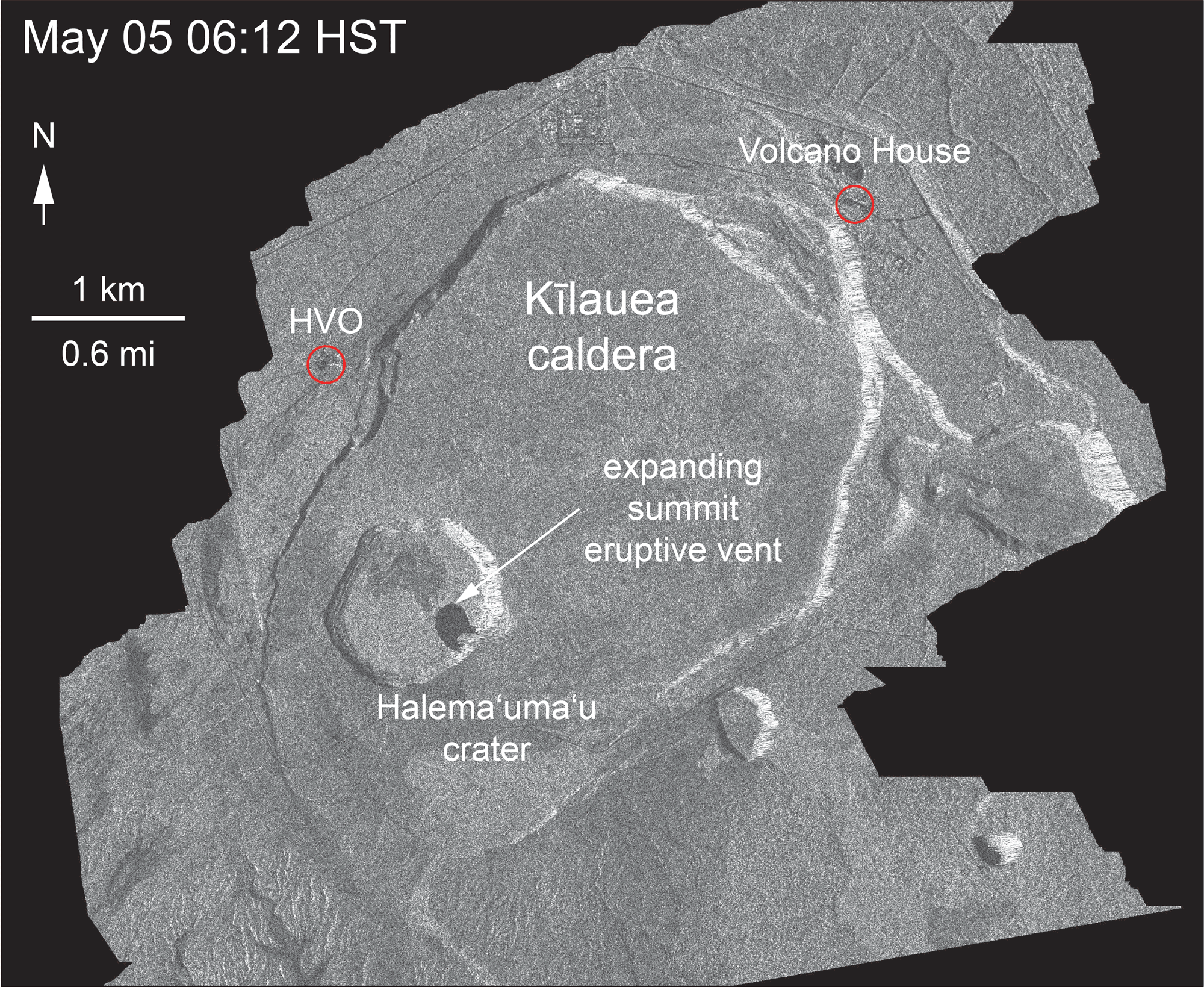
USGS: During the helicopter overflight on June 18, crews captured this image of the growing Halema‘uma‘u crater viewed to the southeast. With HVO and Jagger Museum sitting on the caldera rim (right side, middle where the road bends to the left) it is easier to comprehend the scale of subsidence at the summit. The estimated total volume loss is about 260 million cubic meters as of June 15th. (Full-sized)
Today’s Eruption Summary
Today’s summit explosion came early, 5:05am HST, with a weak ash/gas plume that reached 5,000 feet above sea level (Kilauea is ~4,000). Every one of these explosions means more downdropping and subsidence, resulting in the colossal changes we’re seeing to Halema’uma’u.
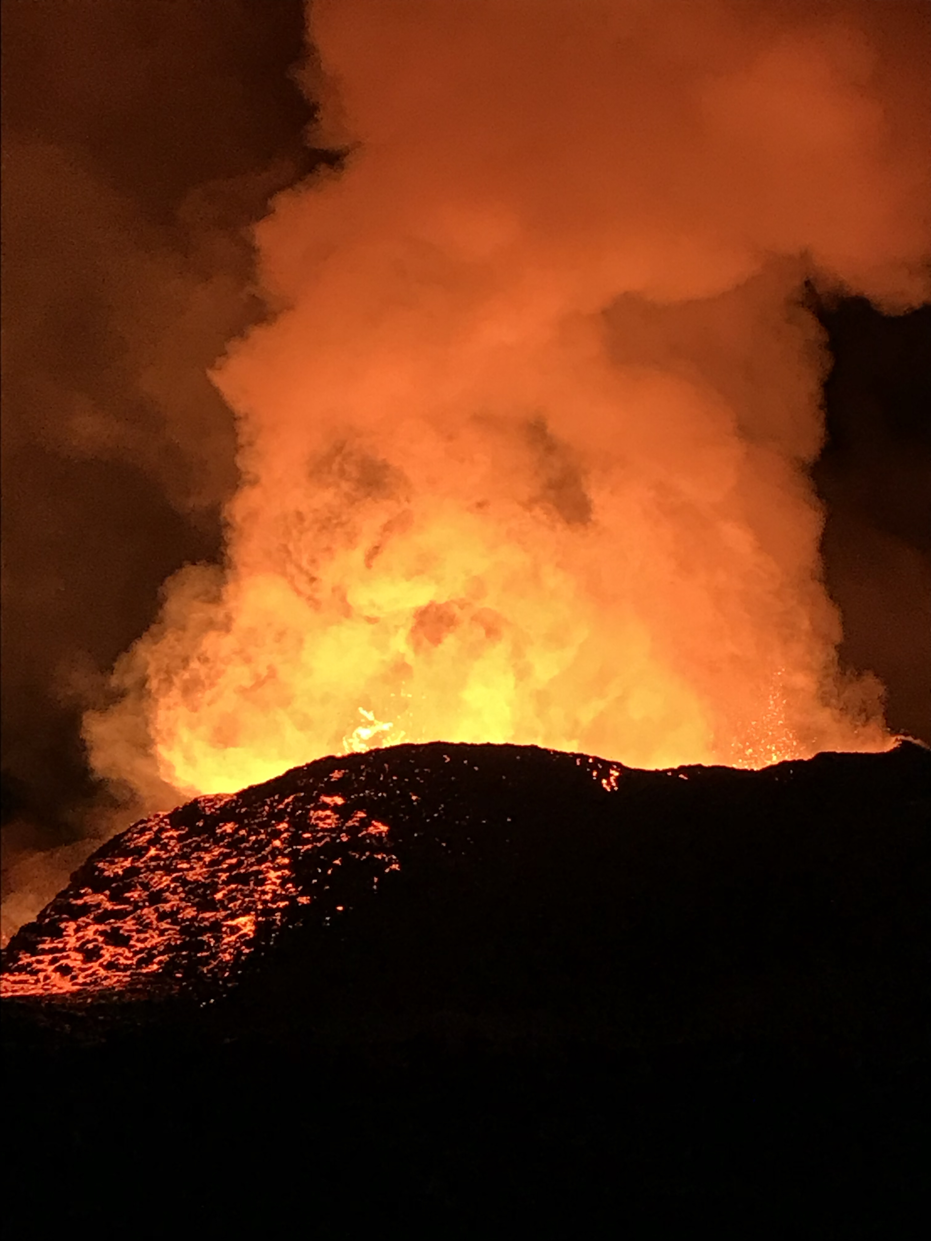
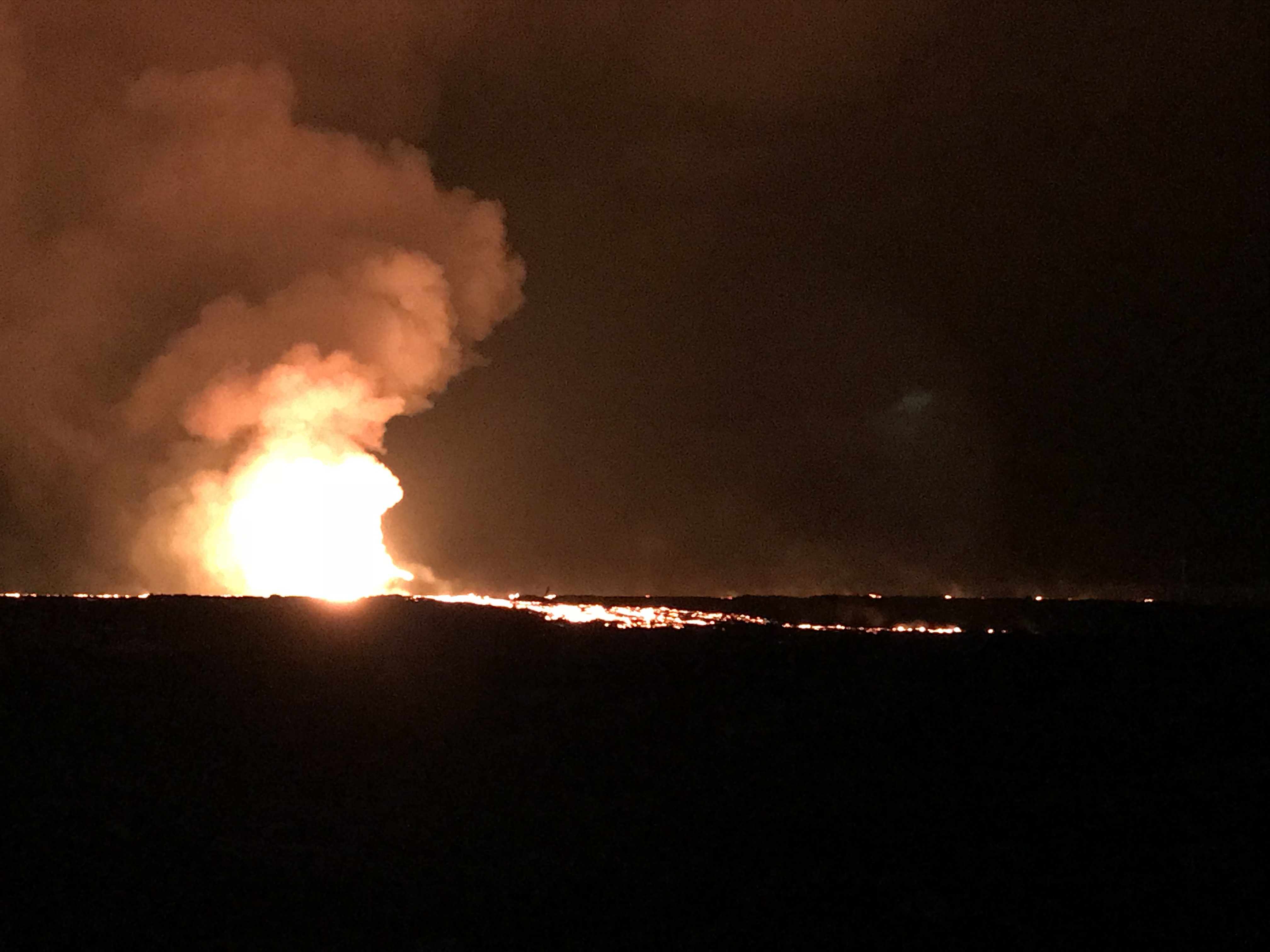
In the Lower East Rift Zone, Fissure 8 climbed back up to 200 foot fountains last night, beefing up the sides of its cone with spatter (but not adding much more height). This morning the river was full to the top of its levees with a few minor breakouts.
Some of these overflows made it past the edge of earlier flows. One went north up Pohoiki Road a short distance before stalling, while another crept northwest along Luana Street. Fissure 6, 15, 16 are “oozing” lava and steaming. Near the ocean, the channel has forked to create two ocean entries, but the only place where it’s still covering more land is a creeping southwest edge of the lava flow in the Vacationland area.
(Above vimeo channel is nothing but daily ocean entry videos.)
More USGS Images and Videos

Video: Overflight and ground views of fissure 8.
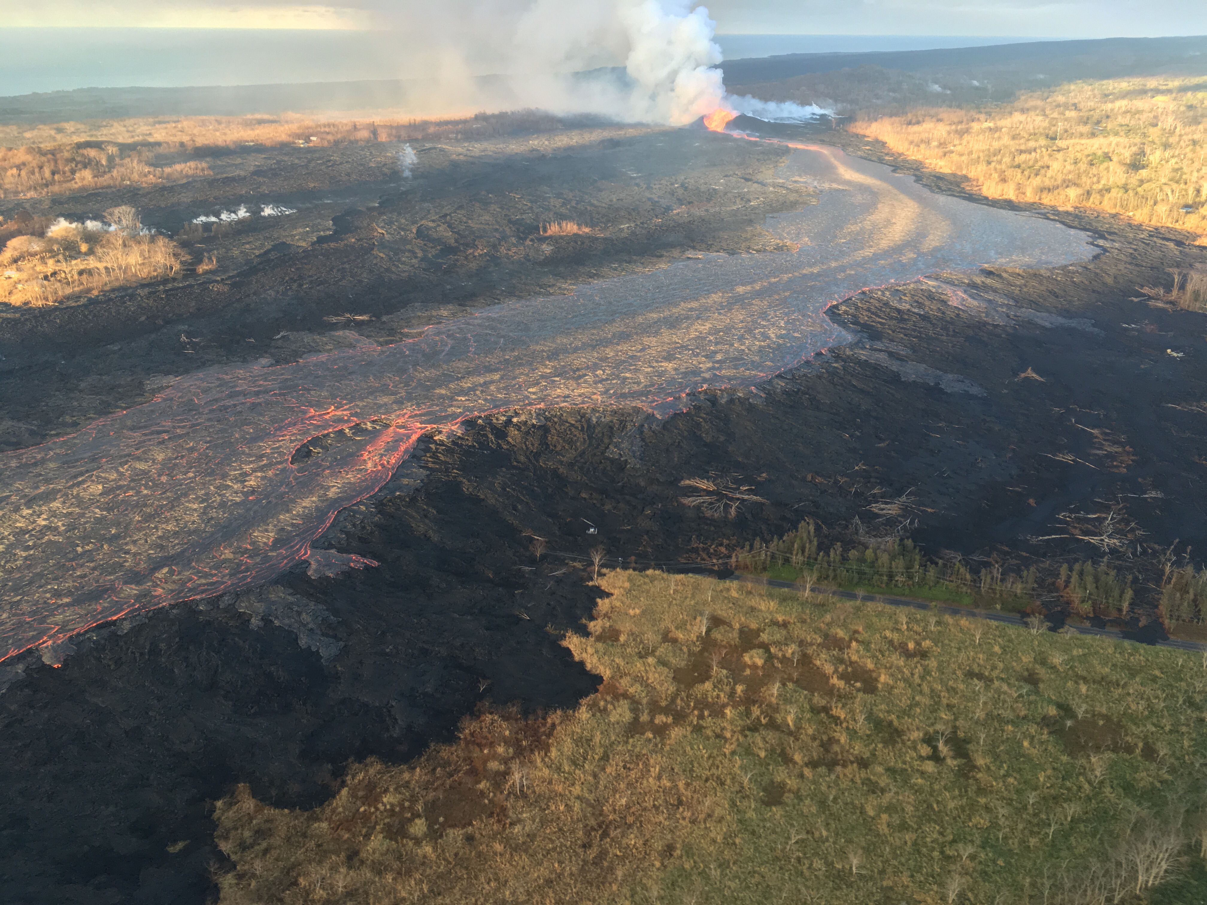
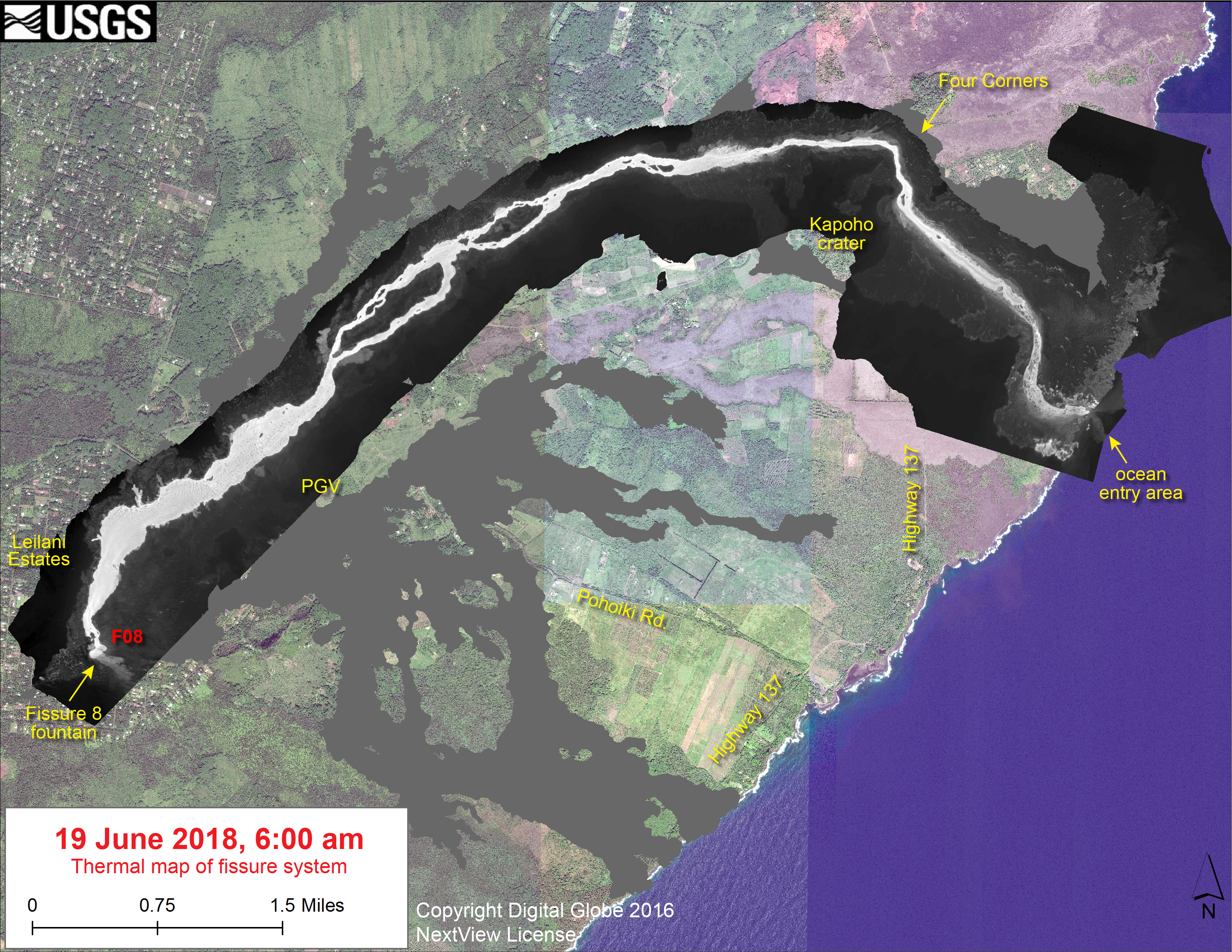
USGS caption: “Geology field crews on the ground near the Kīlauea’s fissure 8 midday on June 19, 2018 observed a still-vigorous channelized lava flow being fed by lava fountains at the vent. Standing waves are visible within the channel. Cascades/rapids are visible near the base of the cone, which is an estimated 50 m (164 ft) high. The maximum flow velocity in the channel is 7.7 m/s (17 mph). During the morning overflight, several small overflows could be seen along the channel margins. The flow of lava is more rapid in the center of the channel and decreases in speed toward the margins where friction with the channel walls increases. The lava flow forks as it nears the ocean, creating two ocean entry points.”
More on the Changes at Halema’uma’u
A new satellite radar animation shows continuing changes at the summit.
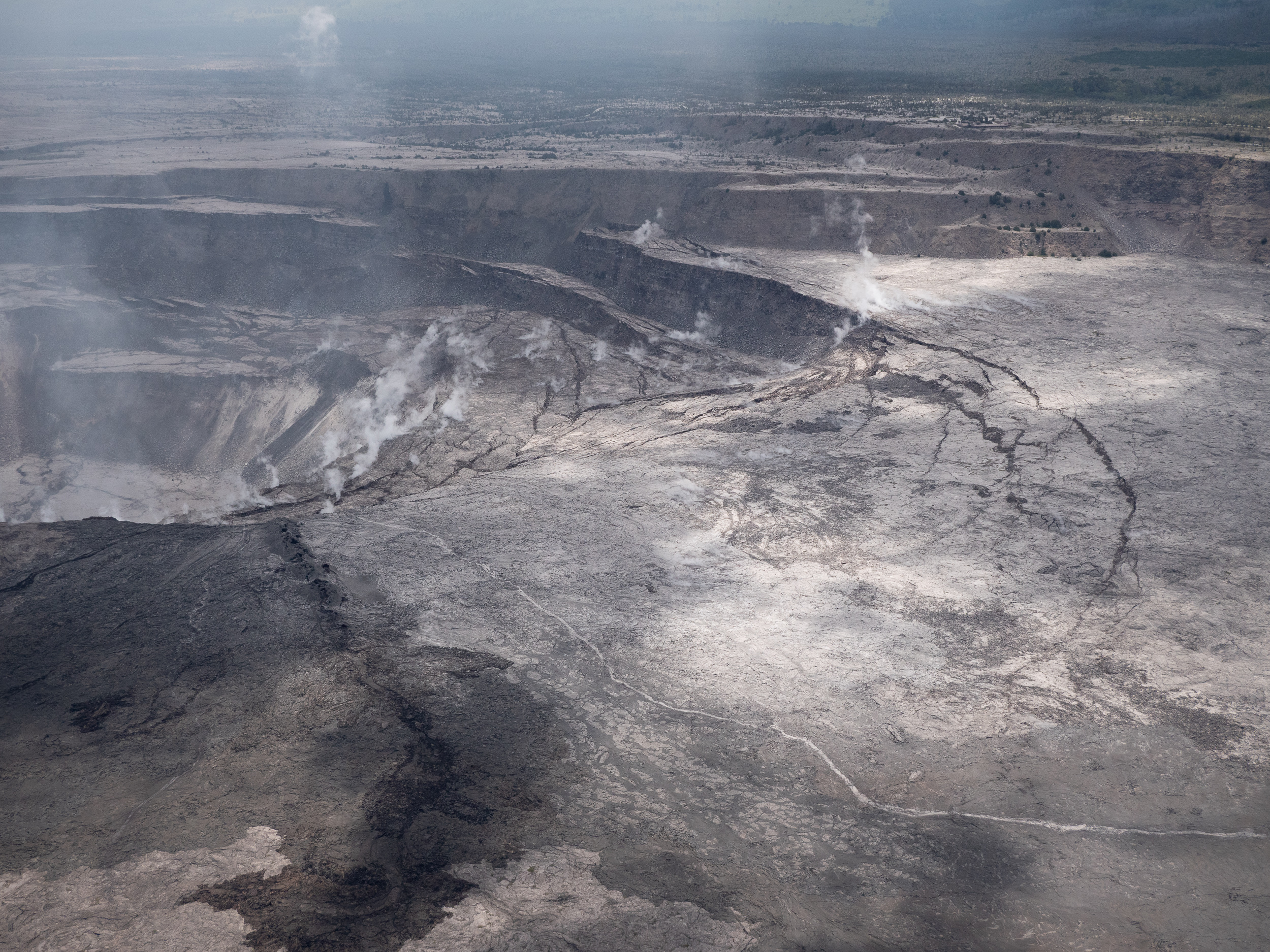
Compare with this April 2018 photo, with camera position slightly farther away, more to the left of the photo above, and facing northwest instead of west:

Question on Facebook: Will it ever refill with lava?
USGS: “A lava lake occupied nearly the entirety of Halema‘uma‘u Crater before the 1924 eruption – the crater was half the size it was prior to May 2018. The lava lake drained in 1924 as magma intruded into the Lower East Rift Zone, and the crater collapsed and grew. However, this is the largest scale collapse of Halema‘uma‘u that we’ve witnessed in historic time. Yes, it will refill with lava – Kīlauea is in a very young stage of its life and it’s still building itself. Eruptions of lava will return to the summit, but it may take many years.”
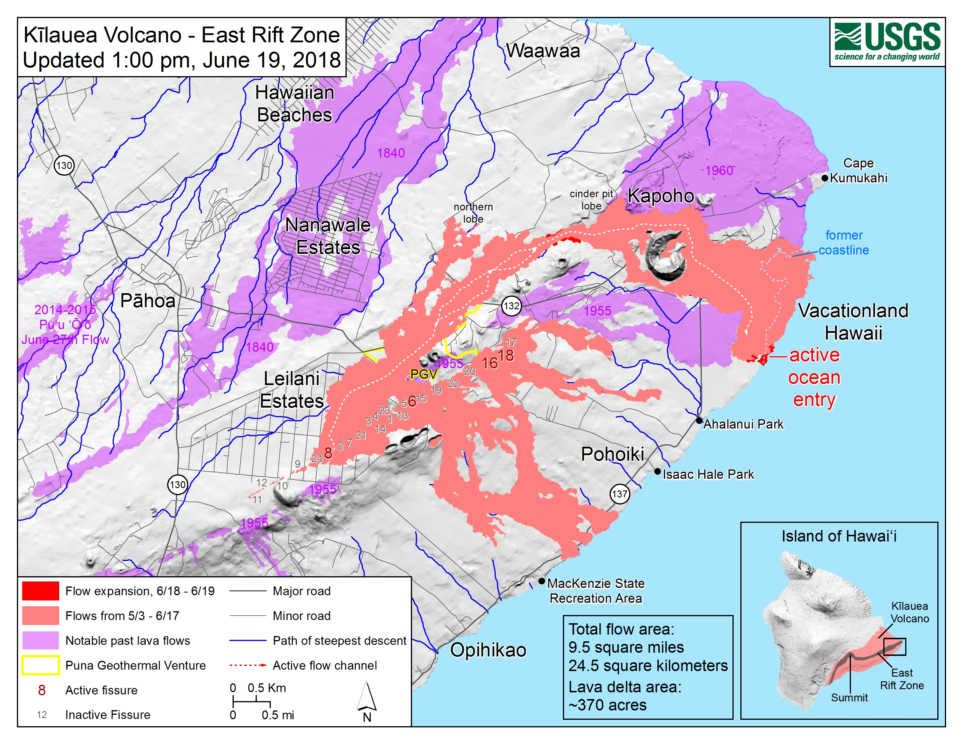
Lower EAst Rift Zone Maps
From Other Scientists
- Maddie Stone, Earther, “Kilauea’s Summit Crater Has Been Radically Transformed”
- Erik Klemetti, Rocky Planet blog, “Kilauea Builds a Cinder Cone and a New Eruption Starts in the Galapagos”
- Bobby C, “Dispatches from Hawaii” Not a western scientist, but a Hawaiian one with a store of native knowledge who observes and reports the details of Kilauea’s ongoing eruptions. Also, today’s entry links to two papers by longtime USGS geologist Don Swanson, studying Hawaiian myths and oral history for clues about the past 400 years of eruptions.
Updated Kilauea summit GPS/seismicity plot showing poor NPIT's descent into Halemaumau crater.. pic.twitter.com/bddCvQt8nP
— Jascha Polet (@CPPGeophysics) June 19, 2018
(USGS said on FB that GPS station is still working, it’s just dropped out of line-of-sight from the radio receiver on HVO’s tower.)
Sentinel1 interferogram (originally tweeted by @USGSVolcanoes) also showing some motion on the Koa'e Fault System (white box and arrow)? pic.twitter.com/XB6Yzzgdek
— Jascha Polet (@CPPGeophysics) June 20, 2018
2018 Eruption SYNOPSIS/Summary
I don’t usually quote anybody but USGS scientists because of copyright, but this excellent comment by “Sherri Dean Taylor” is going to be lost in the abyss of Facebook. (Based on other remarks, I believe she may be a geology grad student). In the comment section after USGS posted the latest photos of Halema’uma’u cracking and slumping:
Sherri Dean Traylor: It seems like the question of the day is how long and how much (and where) is the subsidence.
Key to this question is how big is the summit magma chamber and where is it located. This paper has a pretty good explanation of what we think is down there. In summary, the best guess is a .2 cubic km upper magma reservoir at 1km depth and a similar sized lower reservoir at 4km depth. .13 cubic km have erupted from the east rift zone so far. Clearly some of the magma has come from the upper magma reservoir, how much is unknown.
The where is known (sort of), and that is directly below and slightly east of the Halemaʻumaʻu crater. The deeper chamber is south of Halemaʻumaʻu. Answering the questions. I would expect continued earthquakes and subsidence as long as the erz is so active, as the upper chamber is far from empty and magma is being supplied from the summit. The new crater could get larger but not larger then the boundaries of the upper magma chamber; . As long as magma is being withdrawn from the summit, the show will go on. Sit back and enjoy. USGS Volcanoes feel free to comment and/or correct.
USGS Volcanoes: Good synopsis Sherri. The other thing to note is that space was created within the East Rift Zone when the magma bodies beneath Pu‘u ‘Ō‘ō and Makaopouhi were drained. Also the M6.9 earthquake (plus foreshock and aftershock sequence) probably opened up some space within the ERZ also. So, not only is magma being erupted from the LERZ, but there’s space for magma to fill within the rest of the ERZ. Summit will continue to subside and LERZ will continue to erupt as long as the system remains pressurized. At some point the pressure gradient will shift.”
Brief clip from Mick Kalber
MORE USGS Q&A on Social Media
In general, an eruption stops when it either runs out of magma (a supply issue), when it no longer has enough gas or isn't pressurized enough to make it up out of the vents, when an obstruction in the plumbing system forces it to go elsewhere, or a combination of these.
— USGS Volcanoes🌋 (@USGSVolcanoes) June 19, 2018
Some figures from USGS Facebook and Twitter today:
- Total volume erupted: approximately 250 million cubic meters, “with lots of error bars, because A LOT has entered the ocean.”
- Height of levees within 1/2 mile of Fissure 8: 60 feet.
- Eruption rate of Fissure 8: 100 meters cubed per second, which is ~26,000 gallons (or a little more).
- Fissure 8 cone building began on the evening of May 27.
- Fissure 8’s lava channel is moving 7.7 m/s (17mph) near the vent.
How safe is HVO? “The caldera wall near HVO seems stable for the moment (although we are watching closely…). But the huge number of earthquakes has damaged the building itself, and it is not safe to occupy.” Also: “[the subsidence/collapse] remains on the caldera floor below HVO. We haven’t seen really significant deformation on the caldera rim (there has been some tilting), but it’s something we’re keeping a close eye on.”
From Civil Defense
Standard alert, but BigIslandVideoNews found some excellent lava flow footage to accompany it.
From Local News Outlets
- HSA: “Lava has destroyed 577 homes; quakes continue to shake Big Island”
- HTH: “Geologists monitoring weak activity at fissures 6, 16 and 17”
- HNN: “Farmers brave lava, fumes to tend crops and they’re the lucky ones”
- HNN: “Poor air quality continues to plague Puna residents, alter landscapes”
- HSS: “For National Guard, lava disaster presents real-world mission”
- HNN: “Added stress: Lava evacuees struggle with thieves, trespassers”
- HSA: “Six more citations issued to lava loiterers in lower Puna”
- HNN: “She didn’t have room in her house for lava evacuees, so she opened up her farm”
- HTH: “Doctors to decide Wednesday when mayor can leave hospital”
- HSA: “First days of lava operations for Hawaii County tallied over $1M”
- HCB: Setting up a new livestream facing the ocean entry and distant fissure 8 from an oceanfront house north of Kapoho. (Hopes to have it ready by morning; at the moment it’s dark with sound of ocean.)
#LeilaniEstatesEruption #KilaueaVolcano LATEST: USGS says volume of lava from this eruption has already exceeded 1955 & 1960 amounts with no end in sight; says if & when, #Fissure8 will be named by affected communities – suggestions? https://t.co/BOPU9lPreZ @HawaiiNewsNow #HINews pic.twitter.com/Zl6Ix9vOeX
— Mileka Lincoln (@MilekaLincoln) June 20, 2018
Photographers and Social Media
Brush fires are burning around the parameter of the fissure 8 channel. One on Nohea street was relatively small and mostly smoldering (image attached). The second was just reported on Hwy 132 by the HELCO sub-station, near the 'Y'. #LeilaniEstatesEruption #Kilauea pic.twitter.com/mF5JZO5vJh
— Dane duPont (@GeoGolfHawaii) June 20, 2018
Photos from my overflight of #Kilauea lava fissure #8 this morning with @Paradisecopters & @extremeexposure. #Hawaii @CivilBeat #KilaueaEruption pic.twitter.com/abSe2rgEbi
— Anthony Quintano (@AnthonyQuintano) June 20, 2018
Oh good, one with sounds — and not a helicopter for a change. I know those tree frogs are invasive, but I love their music.
In times of crisis, it's reassuring to see good people rise up to take care of each other. Thank you to the Hawaii @NationalGuard for all your hard work helping the people of Hawaii affected by Kilauea's eruption. pic.twitter.com/sd15T7dV1R
— Misha Collins (@mishacollins) June 20, 2018