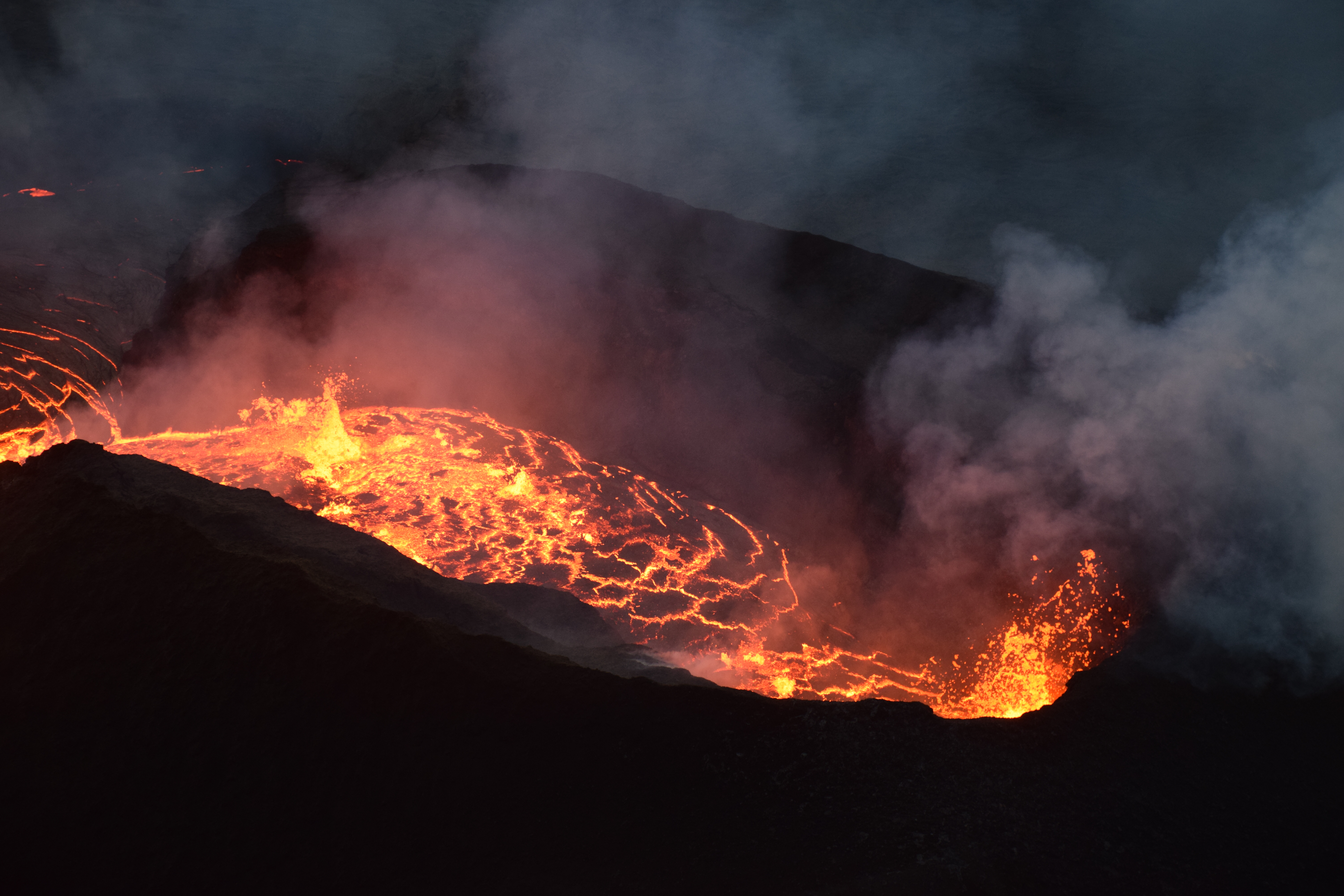
August 2, 2018. USGS: “During this morning’s overflight, HVO geologists used a telephoto lens to capture this image of the fissure 8 cone. Activity within the vent was low, with small bubble bursts in the eastern part of the vent and low lava fountains on the western side. The fountains occasionally threw spatter onto the west rim of the cone (right).” (Full-sized)
Today’s summit collapse came at 11:55 am HST, energy equivalent of an M 5.4. Once again there was a cluster of high M3 foreshocks in the ten minutes or so beforehand, so that there was already some suspended dust from rockfalls.
Northeast Rim livestream cam was stuttering today, but still dramatic.
Also note that HVO’s Fissure 8 webcam was damaged by a brushfire Tuesday and ceased working. In fact, right now it’s stuck on the last photo it took.
While checking on the main webcams page, I caught a lovely time of the evening up at the summit. From the ones that are working:
Former Overlook Vent cam, now pointed at a sheer cliff above where it used to be. (Full-sized)HVO Panorama cam. All of these from about 6:40 pm HST. (Full-sized)Halema’uma’u wide angle webcam. (Full-sized)
And speaking of photos, I took a night off, and come back to find HVO posted a ton of good photos! Which I shall mirror here so they’re easier to find after they’ve “fallen off” that Photo & Chronology page.
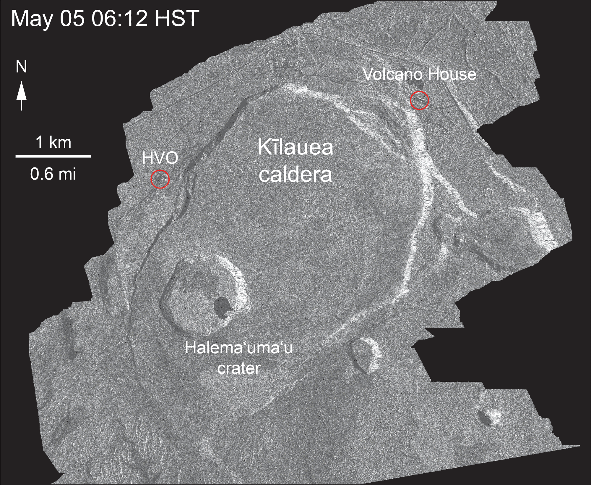
Most importantly, a new frame from the Cosmo-Skymed satellite radar animation:
Aug 1, 2018. USGS: “This animated GIF shows a sequence of radar amplitude images that were acquired by the Agenzia Spaziale Italiana CosmoSkyMed satellite system. The images illustrate changes to the caldera area of Kīlauea Volcano that occurred between May 5 and August 1 at about 6:00 a.m. HST.” (Full-sized
Accompanying text with this animation: “Over time, expansion of the summit eruptive vent within Halema‘uma‘u crater and the widening of Halema‘uma‘u itself are obvious. Starting in late May, the development of several cracks outside Halema‘uma‘u is clear, and inward slumping of a large portion of the western, southwestern, and northern crater rim begins. Much of this motion appears to be coincident with the small explosions from the summit that have taken place on a near daily basis since early June. The most recent radar scene, from August 1, shows continued motion along cracks over a broader area of the caldera floor, extending east of Halema‘uma‘u. We expect this slumping to continue as long as the collapse events and overall subsidence persist.”
Eruption continues as usual with three minor things to note. First: “fuming” on the southwestern margin of the flow near Pohoiki could mean possible breakouts, according to today’s HVO Kilauea status update.
Same source also says that, rather unusually, a 4.1 earthquake at 10:02 pm was felt all the way to Hilo, far more widely than the stronger summit collapse events, possibly because it was at a depth of 7 miles.
And finally, Tuesday will mark the 89th day of the eruption, surpassing the length of the 1955 Kapoho eruption which had previously held the record for the longest LERZ eruption since westerners arrived and began keeping records.
I tweeted him a question about “Halema’uma’u Caldera,” which he seems to be using instead of “Kīlauea caldera.” I know Halemaʻumaʻu crater has expanded so much it could be classified as a caldera now, but so far HVO scientists have resisted doing so, to avoid confusion with the larger, older caldera.
July 30 HCFD Overflight Photos
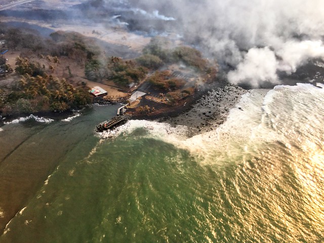
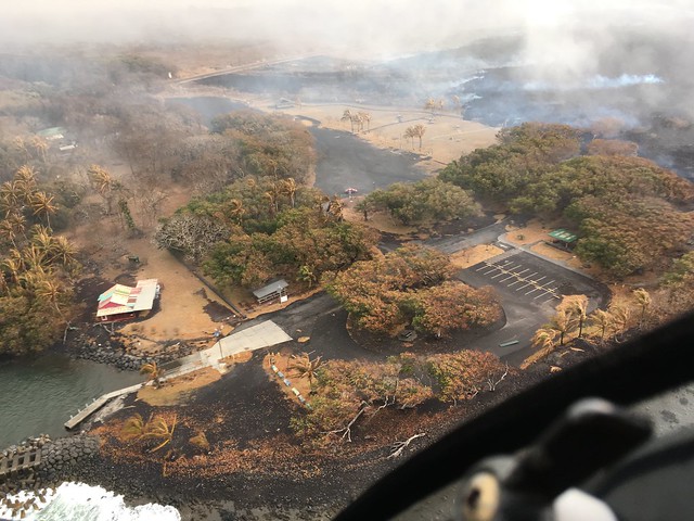
HCFD’s July 30 album is up on Flickr. Just 12 photos plus the video clip at the top of this post. Including the clearest views we’ve seen of Isaac Hale Park in some time, since the laze plume wasn’t in the way:
Here’s a few USGS photos from today plus the LERZ map, and overflight video and photos from Mick and Bruce:
Before and after: a new aerial photo of HVO on the rim of Kīlauea Caldera shows how greatly Halemaʻumaʻu has changed. For comparison, I found this 2008 photo in the USGS archives:
And here’s today’s overflight photo, from farther away.
July 29, 2018. USGS: “This aerial view of Kīlauea’s summit (taken early yesterday morning, looking south) shows some well-known features and some that are now more obvious as a result of ongoing collapse of Halema‘uma‘u and parts of the summit caldera floor. Crater Rim Drive (lower right) leads to the USGS Hawaiian Volcano Observatory and NPS Jaggar Museum (right, middle), perched on the caldera rim and overlooking the growing Halema‘uma‘u. Ground cracks, parallel to the crater rim, are visible on the north side of Halema‘uma‘u (left side of image—also see our July 28 photo). South Sulphur Bank stands out as the light-colored area on the opposite crater wall (see our July 22 photo for a closer view of this feature).” (Full-sized)
The scientists of HVO had to abandon their 100-year-old observatory on the caldera rim mid-May. During the summer session, the University of Hilo was able to provide them with plenty of space for a temporary HQ. With fall term around the corner, HVO has leased part of the U.S. Customs Building in Hilo while they seek a more permanent solution. Because if and when the summit stabilizes, the old observatory will have to be rebuilt, or at the very least, will require massive repairs.
Speaking of the summit, today’s collapse event was at 12:10 pm, energy equivalent of M5.4. I captured the rockfalls 3-4 minutes before, as well as the actual summit collapse:
The clock on the Northeast Caldera Rim livestream is about a minute fast, but it’s so tiny you can’t see it anyway. The actual collapse starts about 1:30 into this video:
No changes on the Lower East Rift Zone eruption today.
Here’s the other HVO images for July 29 (as usual, I’m mirroring them because the HVO “Photo and Video Chronology” page only shows the 20 most recent entries, making images older than two weeks somewhat inaccessible.)
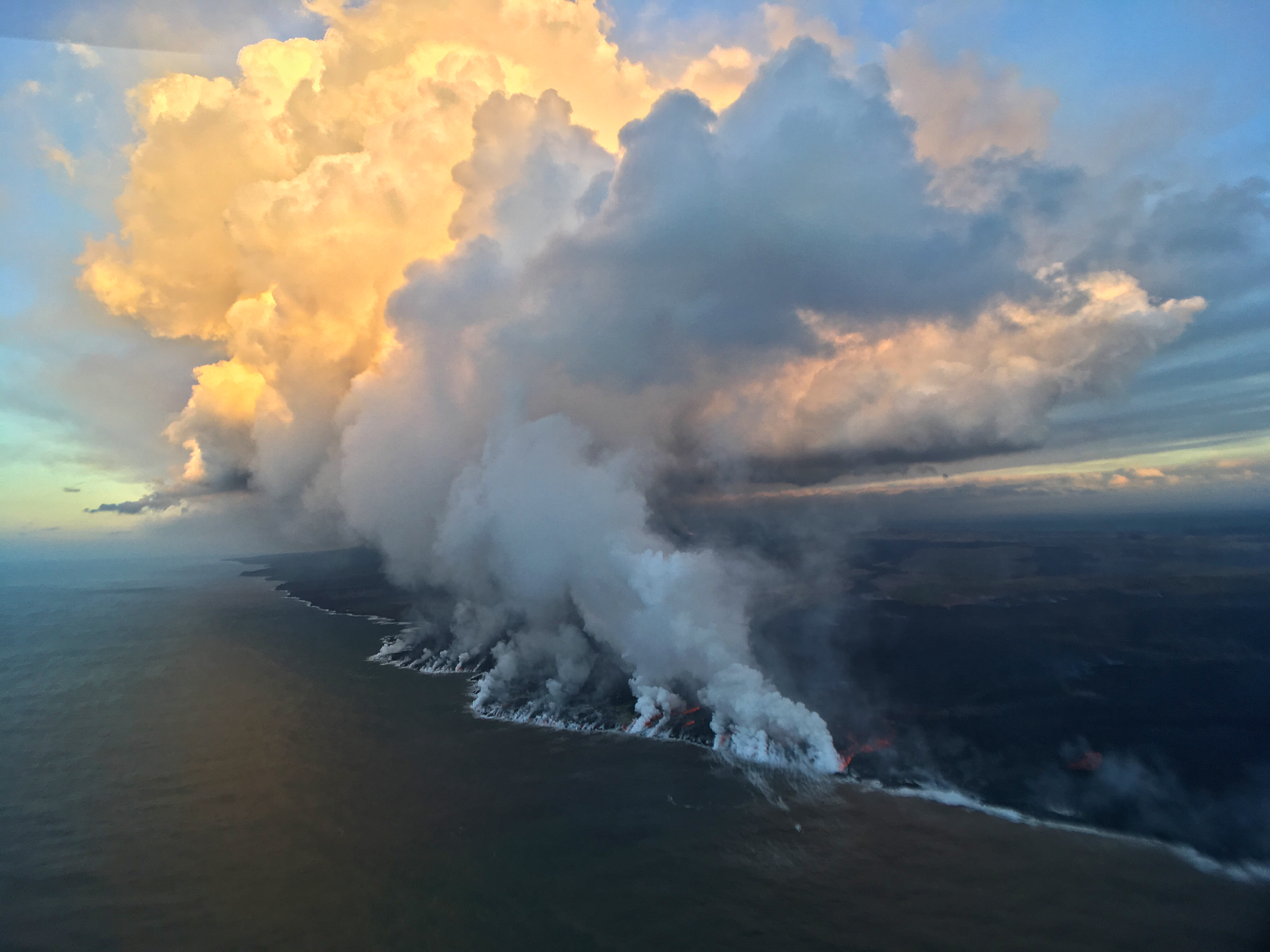
July 25, 2018. USGS: “Early this morning, several small lobes of lava were oozing out from crusted ‘a‘ā flows along the southern ocean entry.” (Full-sized)
Today’s Eruption Summary
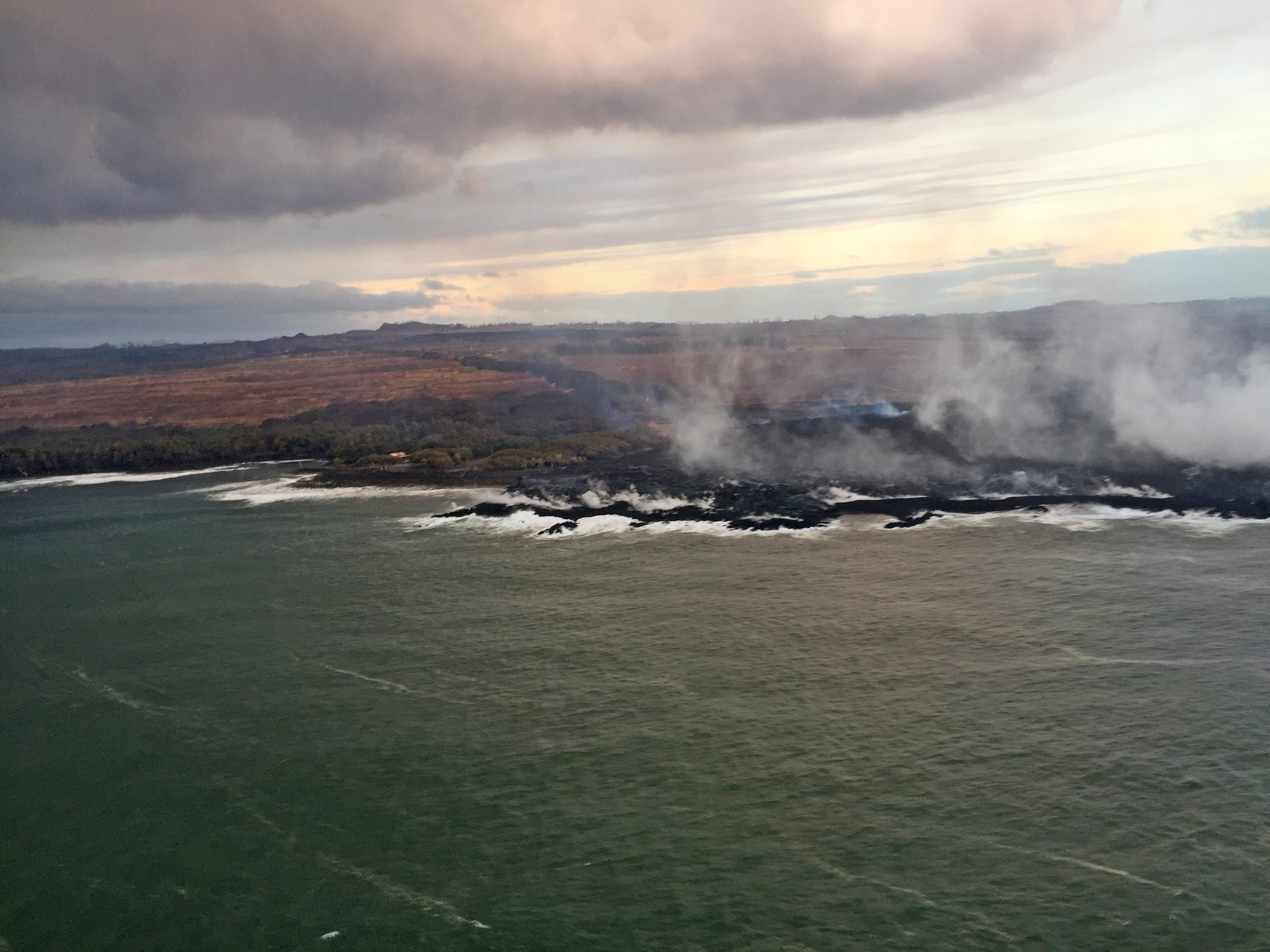
As we approach the 3-month mark— or pass it, since Puʻu ʻŌʻō’s floor collapsed 3 months ago this past Monday— Kīlauea’s 2018 eruption continues with no significant changes. During the USGS morning overflight, the lava’s southwestern margin was holding at less than a tenth of a mile from Pohoiki boat ramp. The vigorous ocean entry continues a few hundred yards to the east. No surges in lava output have been reported at Fissure 8 since Tuesday’s 6:41 am summit collapse.
July 25, 2018. USGS: ” HVO’s overflight early this morning revealed little advancement of the westernmost ocean entry. During the overflight, lava was approximately 145 m (475 ft) from the boat ramp at Isaac Hale Park (near the light-colored structure just left of center in this photo).” (Full-sized)
A deceptive moment of tranquility at the new, extensively remodeled summit:
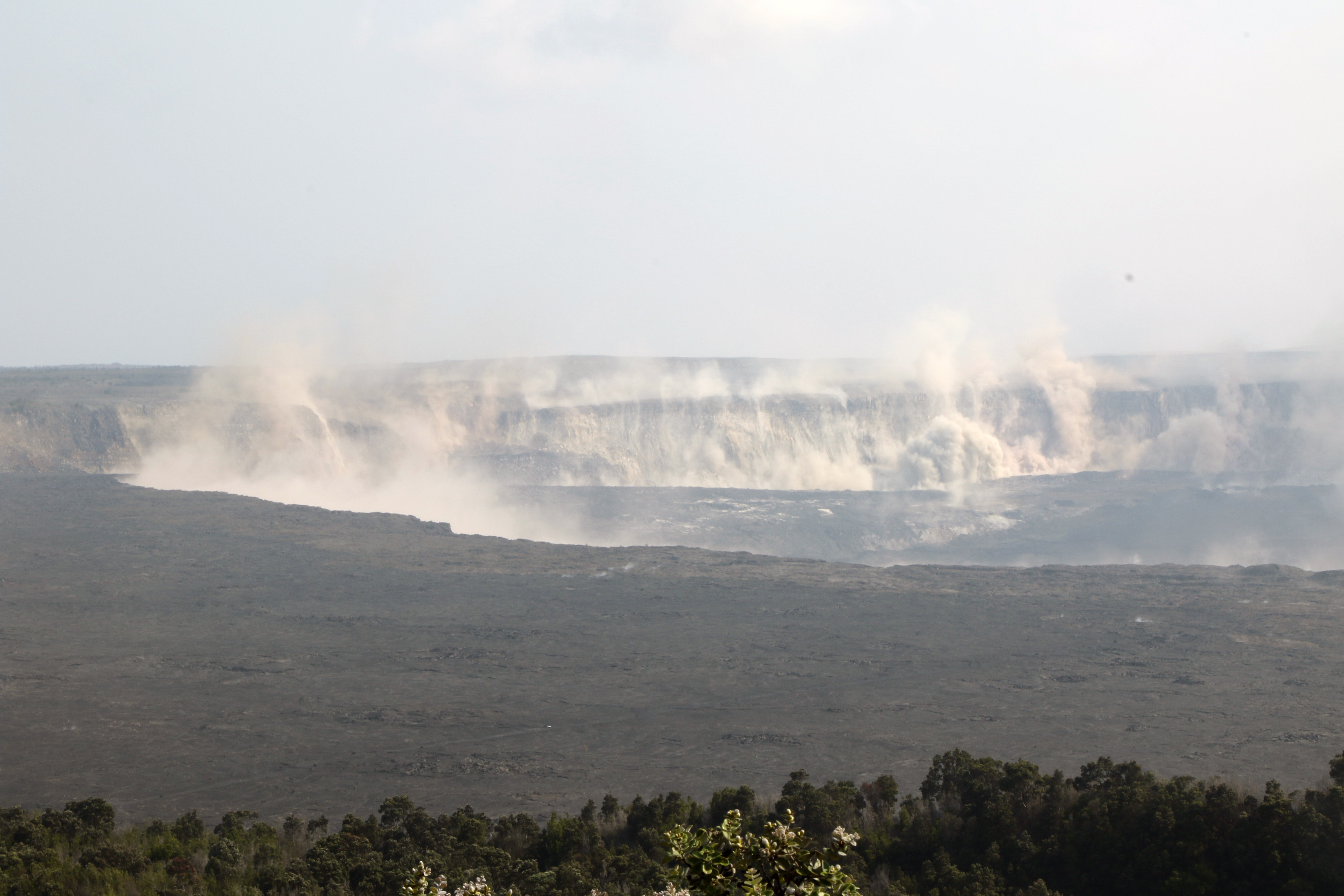
July 25, 2018. USGS: “Earthquakes shook the ground at Kīlauea’s summit late this afternoon, stirring up rock dust within Halema‘uma‘u and along the caldera walls. This view from the northeast caldera rim looks across at the Keanakāko‘i and South Sulphur Banks areas.” (Full-sized)
Here’s HVO’s Steve Brantley giving the weekly eruption update at last night’s Pahoa community meeting (I’ll be transcribing it tomorrow or Friday).
He explains that complicated “lavashed” map released earlier this week, which predicts where lava is most likely to go if there’s a breakout along particular stretches of Fissure 8’s lava channel. This is an aid to residents living in neighboring areas not affected by lava now, but who are worried about what might happen if the flow diverts.
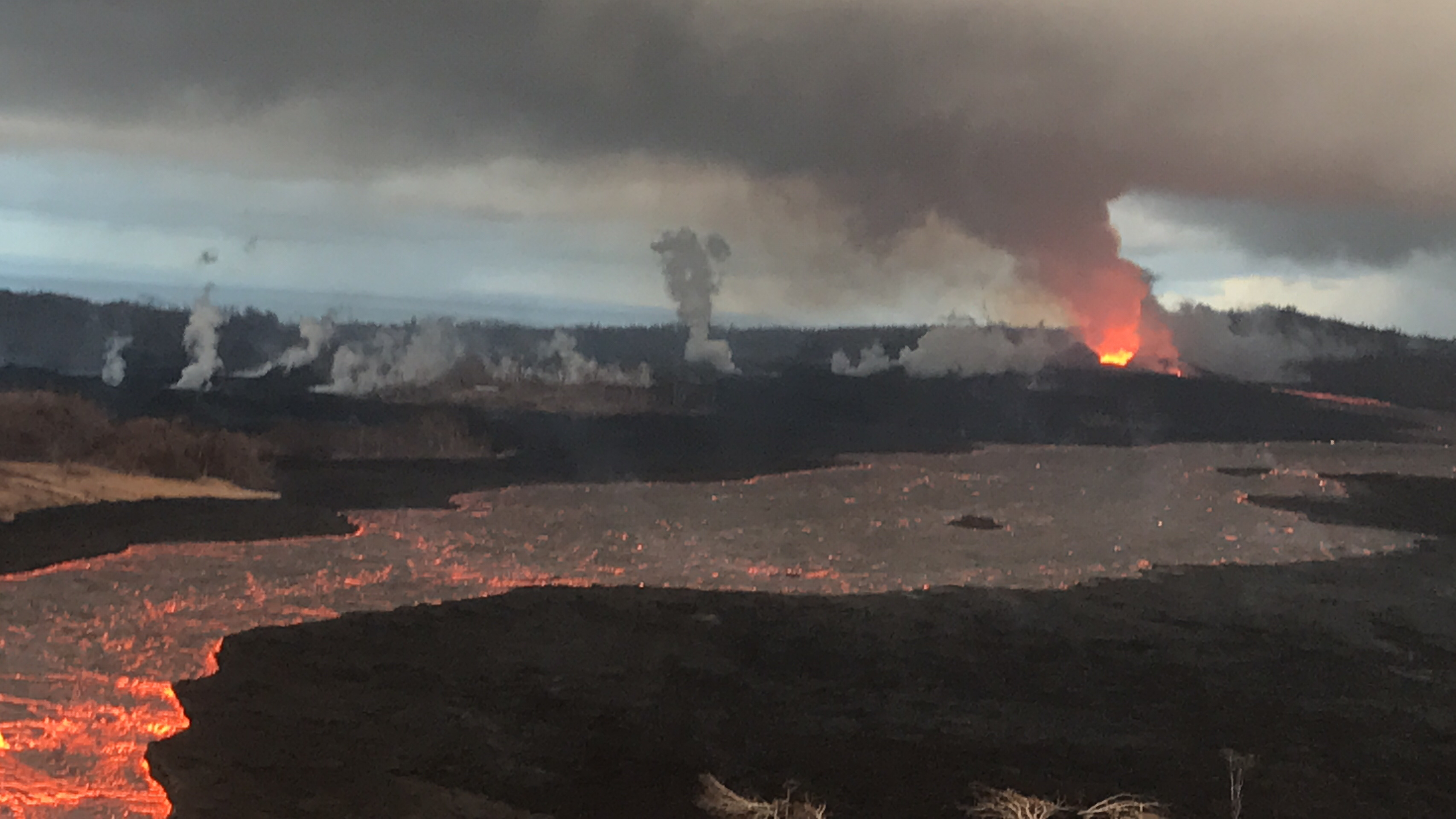
July 7, 2018. A brooding Mordor-scape around Fissure 8 during the USGS morning overflight. (Full-sized)
Today’s Eruption Summary
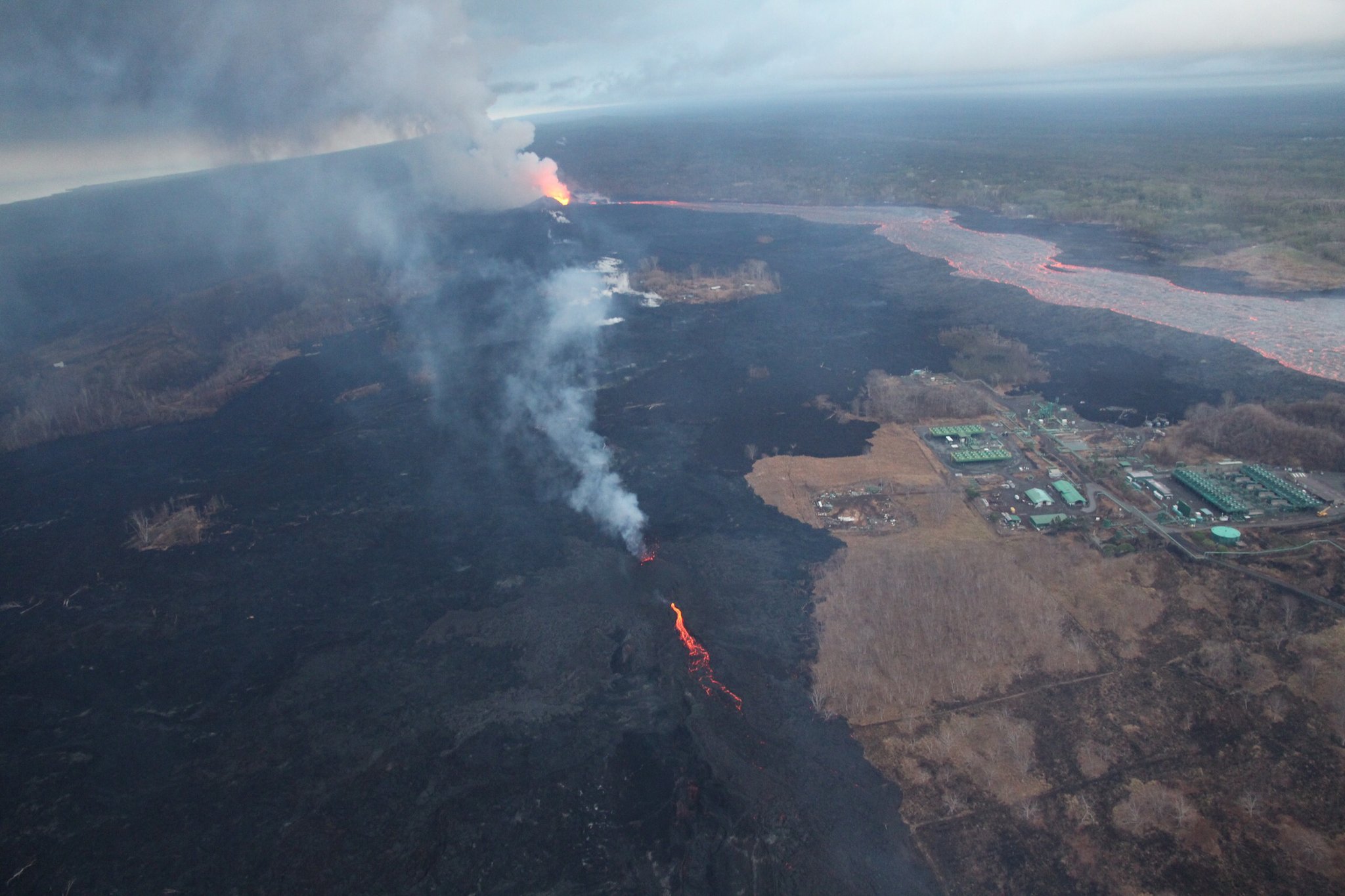
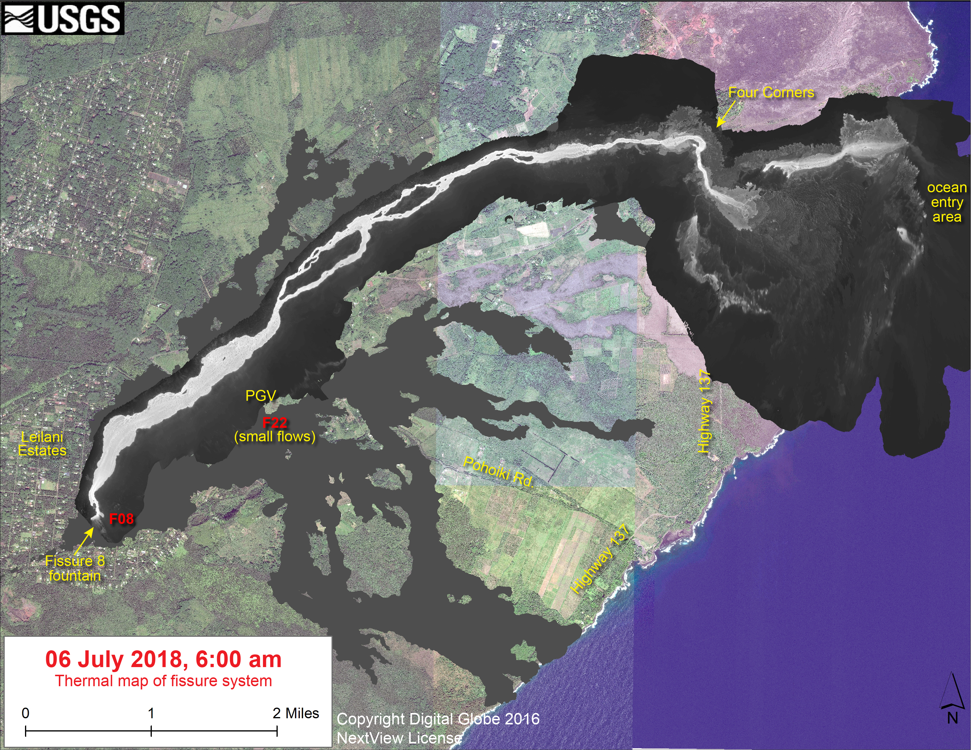
The Lower East Rift Zone continues as usual, more or less. Fissure 8’s fountains remain tucked down in their 180′ cone, sending a river towards Kapoho. However, yesterday’s thermal map shows “the channel flow seems to stall about 2km (1.2 mi) inland of the coast.” Instead of entering the ocean from the channel, it’s oozing out here and there along a wide span of the delta, mostly on the north side. Also, lava is oozing out on both sides of the main a’a field, to the north (still menacing the narrow remnants of Kapoho Beach Lots, and it looks like it’s made a bit of a surface flow there) and southwest.
Fissure 22 is weakly spattering. And as of 9pm HST, we’re still waiting for today’s collapse event at the summit.
Apart from the weather, today was a slow news day for Kilauea watchers. So it’s a good time to catch up on this week’s Volcano Watch, HVO’s weekly column:
Between computer troubles (fixed now!) and that all-important Volcano Village meeting last Thursday evening, I missed the July 5 11am USGS media conference call. Here’s the archived audio file.
It was short, but for completeness’ sake, here’s a transcript.
[Note: Posted July 9, 3.30pm HST, backdated to keep it in correct order chronologically.]
This post got long, so I’ve moved the Q&A session to Part 3. Again, I’m transcribing what HVO geologists had to say at the June 28 Volcano Village community meeting.
Part 1 was Kyle Anderson’s talk on seismicity and ground deformation— lots of nitty gritty science— while Part 2 was Don Swanson’s slideshow of some of the visible changes he’s observed within Kīlauea Caldera, with a lot of photos I haven’t seen anywhere else.
Here’s the video of the whole meeting.
Here’s my transcription of the Q&A session. A lot of these questions have already been answered online, but I like hearing direct, personal responses from some of the senior HVO scientists:
Fissure 8 gushes on unchallenged and unchanged, while Fissure 22 — remember the chief subject of Lavacam?— has started spattering 50-80m and sending out a modest lava flow headed NE along the edge of previous flows.
USGS photo from morning overflight, July 1, 2018. Fissure 8 in the distance, Fissure 22 in the middle ground across from PGV. (Full-sized)
Down at the coast, lava continues to ooze out from under much of the northern part of the delta along a broad front, with “pasty” lava squeezing out in several places along Kapoho Beach Lots.
As of 8:30pm 11pm HST, I’m waiting for confirmation of the next summit collapse/explosion.
Besides Fissure 22 reactivating in earnest, the news today is that new digital elevation maps and satellite images give us a clear view of the subsidence of Kilauea Caldera around Halema’uma’u, which has begun to show in livestream and webcam views lately.
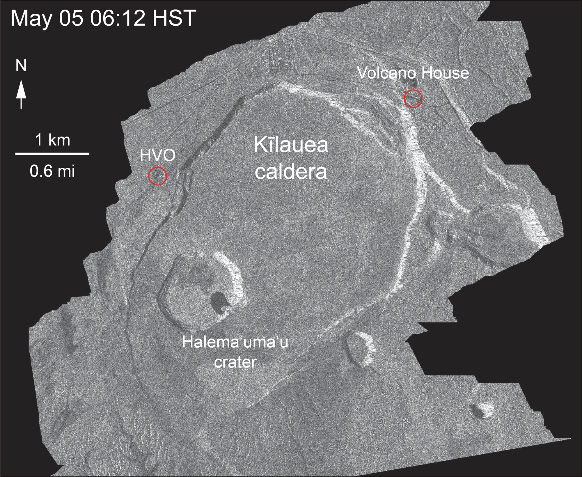
First of all, USGS seismologist Kyle Anderson posted this color-coded slide of caldera ground deformation in his Thursday evening talk:
The colors compare the new June 19, 2018 drone-surveillance digital elevation map with a DEM of the caldera captured in 2009. Presumably the light gray areas within Halema’uma’u don’t correspond to anything on the older map, so can’t be compared. Green patches are earthquakes over the past few days indicating stress. And “300+ ft” marks the last known position of the NPIT GPS sensor before it sank out of radio contact. (Full-sized)
Next, the Italian Space Agency’s trusty Cosmo-Skymed satellite has sent us another radar survey of Kilauea. Even though I’d observed dramatic subsidence of the caldera floor in recent livestream and webcam images, the last frame of this animation made me gasp:
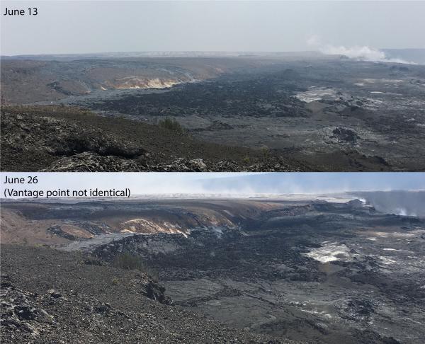
USGS: “This animated GIF shows a sequence of radar amplitude images that were acquired by the Agenzia Spaziale Italiana CosmoSkyMed satellite system. The images illustrate changes to the caldera area of Kīlauea Volcano that occurred between May 5 and June 30 at about 6:00 a.m. HST[…] Over time, expansion of the summit eruptive vent within Halema‘uma‘u crater and the widening of Halema‘uma‘u itself are clear. Starting in late May, the development of several cracks outside Halema‘uma‘u is clear, and inward slumping of a large portion of the western, southwestern, and northern crater rim begins. Much of this motion appears to be coincident with the small explosions from the summit that have taken place on a near daily basis since early June. The most recent radar scene, from June 30, shows the formation of cracks over a broader area of the caldera floor, extending east of Halema‘uma‘u (these cracks are the scarps seen in recent photographs from the Keanakākoʻi overlook area). We expect this slumping to continue as long as the collapse events and overall subsidence persist. (Full-sized)We are well on our way to a nested caldera, with Halema’uma’u taking up over half the larger caldera floor. I’m hoping those earthquakes indicate where the edge of the new inner caldera will be, but I’m not a geologist. Here’s those scarps they mentioned, posted a few days ago:
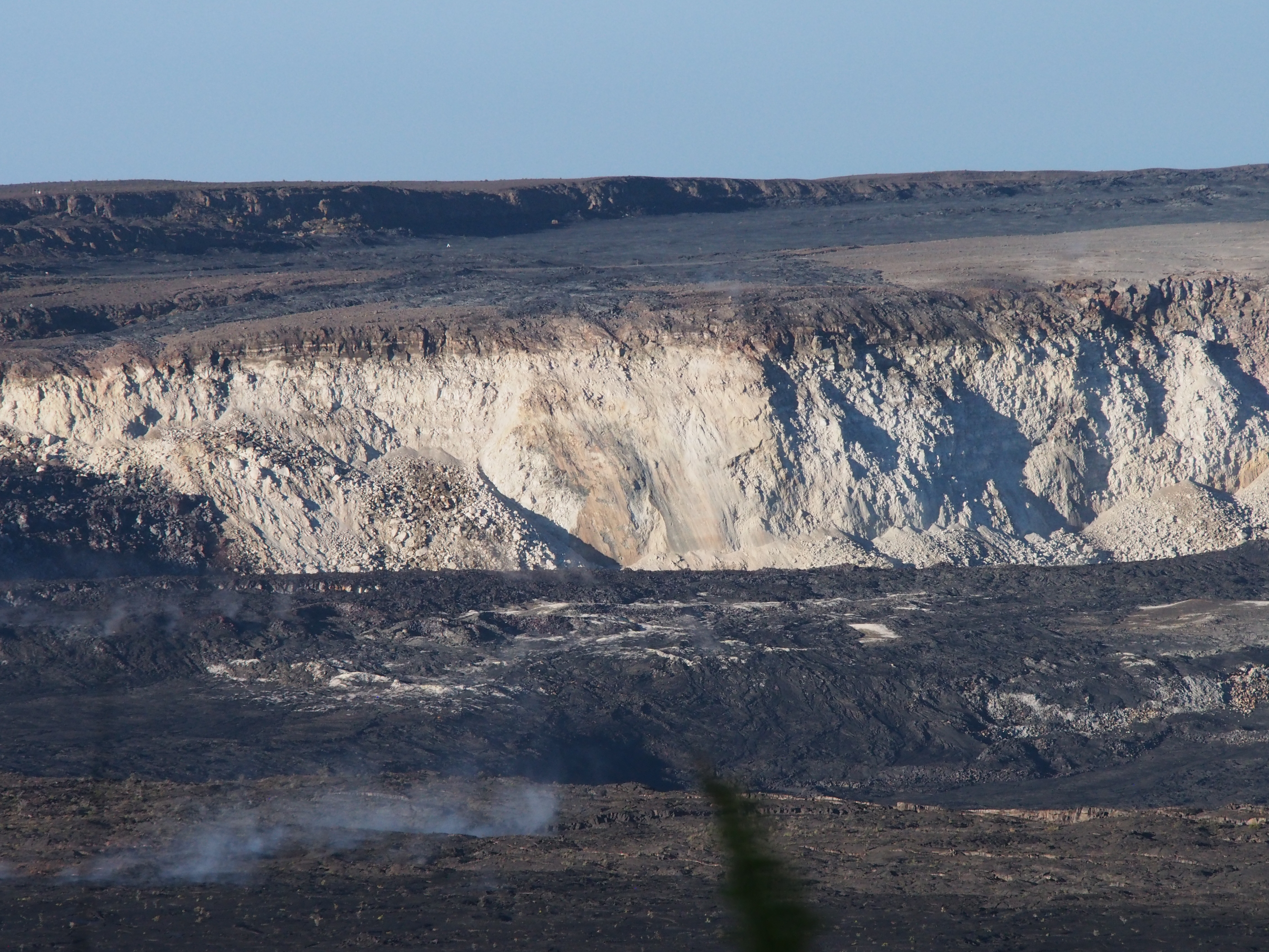
USGS: “Comparison of photographs taken on June 13 and 26 from near Keanakāko’i Crater overlook in Hawai’i Volcanoes National Park shows a subsidence scarp that formed as the Kīlauea Crater floor subsided. Scientists estimate the dramatic dropping of the crater floor in this area occurred sometime between June 23 and 26. The view is to the west. Halema‘uma‘u crater is in upper right.” (Full-sized)
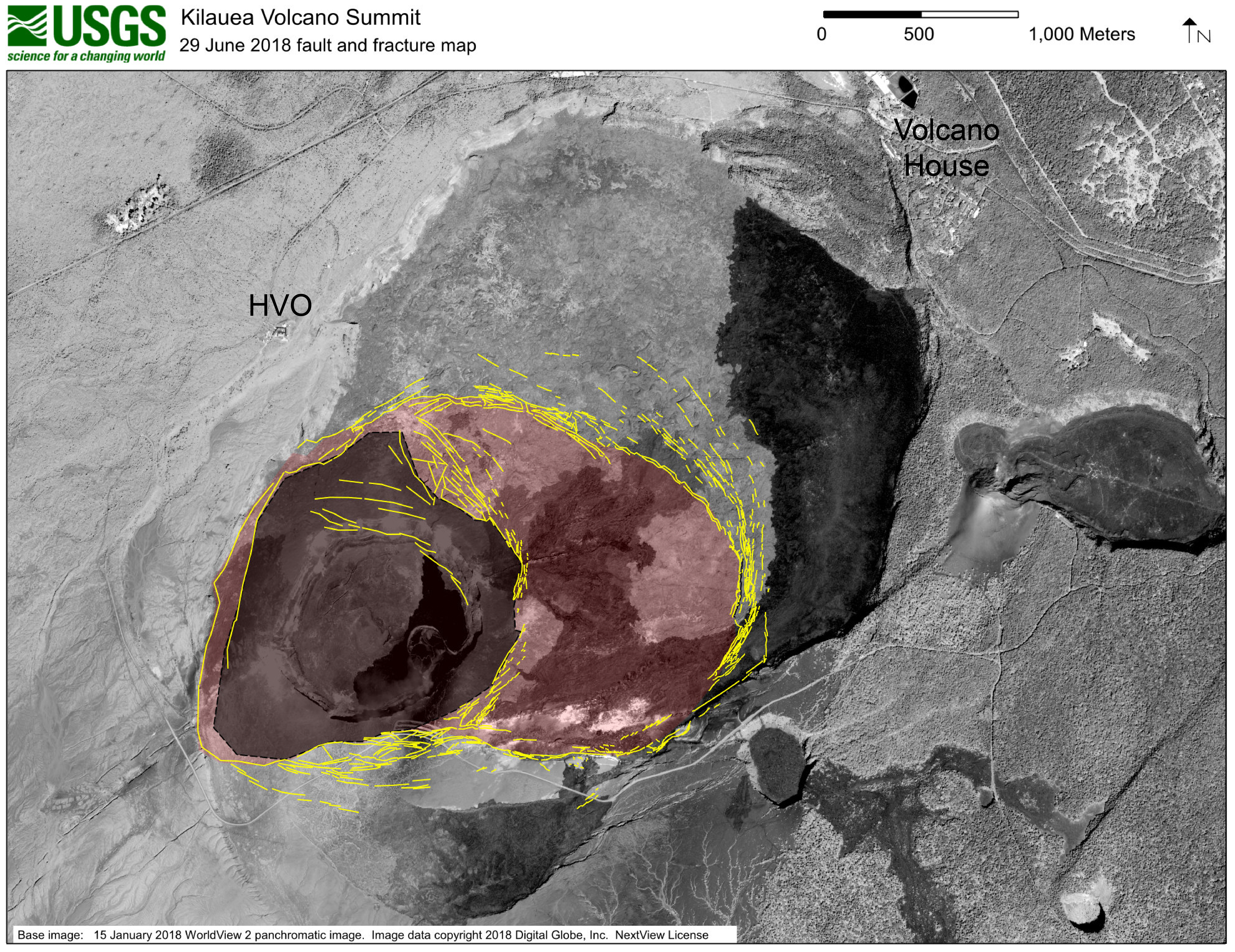
Last but not least, the USGS posted this map of the fracturing around Halema’uma’u. Note that the diagram is projected onto a satellite photo of the pre-May caldera, so there’s a ghostly image of the Halema’uma’u we remember in that dark gray area.
USGS: “This map shows major fractures in yellow (as of June 29) on a base image acquired by the WorldView-2 satellite before the current sequence of events began at Kīlauea. The area of major subsidence has expanded east and south, and slightly west, of the main Halema‘uma‘u crater area. The large, red-shaded area east of Halema‘uma‘u is moving down within a scarp-bounded area, as seen in recent photographs of the summit. Some fractures have also formed to the east-northeast of the red-shaded area of accelerated motion, and also on the south caldera rim where parts of the caldera wall have slumped into the rapidly moving caldera floor below. The dark gray-shaded area within the red shaded area shows the region of most significant down dropping and is currently the deepest part of Kīlauea caldera.” (Full-sized)
So there you have it. Who would’ve thought the draining of the lava lake, which was minuscule compared to the whole summit caldera, would’ve had a domino effect this large?
On Thursday, there was an hour and a half meeting with the USGS, National Park Service and residents of Volcano Village. Above is a video of the whole meeting. As usual, I’m interested in the geology, and so I’ve made a transcript of that part of the meeting. The first half of Kyle Anderson’s talk rehashes the “collapse/explosion” events that we’ve covered before, but the second half has a timelapse of Halema’uma’u from June 1st to June 28th — which I’ve rebuilt frame by frame, since I could just make out the timestamps— plus the latest Digital Elevation Model of Kilauea’s summit showing the slumping not only in Halema’uma’u, but across part of the caldera floor.
Scientist-in-Charge Tina Neal (HVO)
[5:40] [Introductory remarks, greetings and thanks]
[6:20] So tonight you’ll hear from familiar faces, Kyle Anderson and Don Swanson, who will give you an update on what the volcano is doing, what we think is happening, and we’ll touch on this very important question of how long and how big. Those are very hard questions to answer, so let me just preview that we’re not going to give you a wonderful take-away that will solve all that uncertainty. But we’ll do the best we can.


