Before and after: a new aerial photo of HVO on the rim of Kīlauea Caldera shows how greatly Halemaʻumaʻu has changed. For comparison, I found this 2008 photo in the USGS archives:
And here’s today’s overflight photo, from farther away.
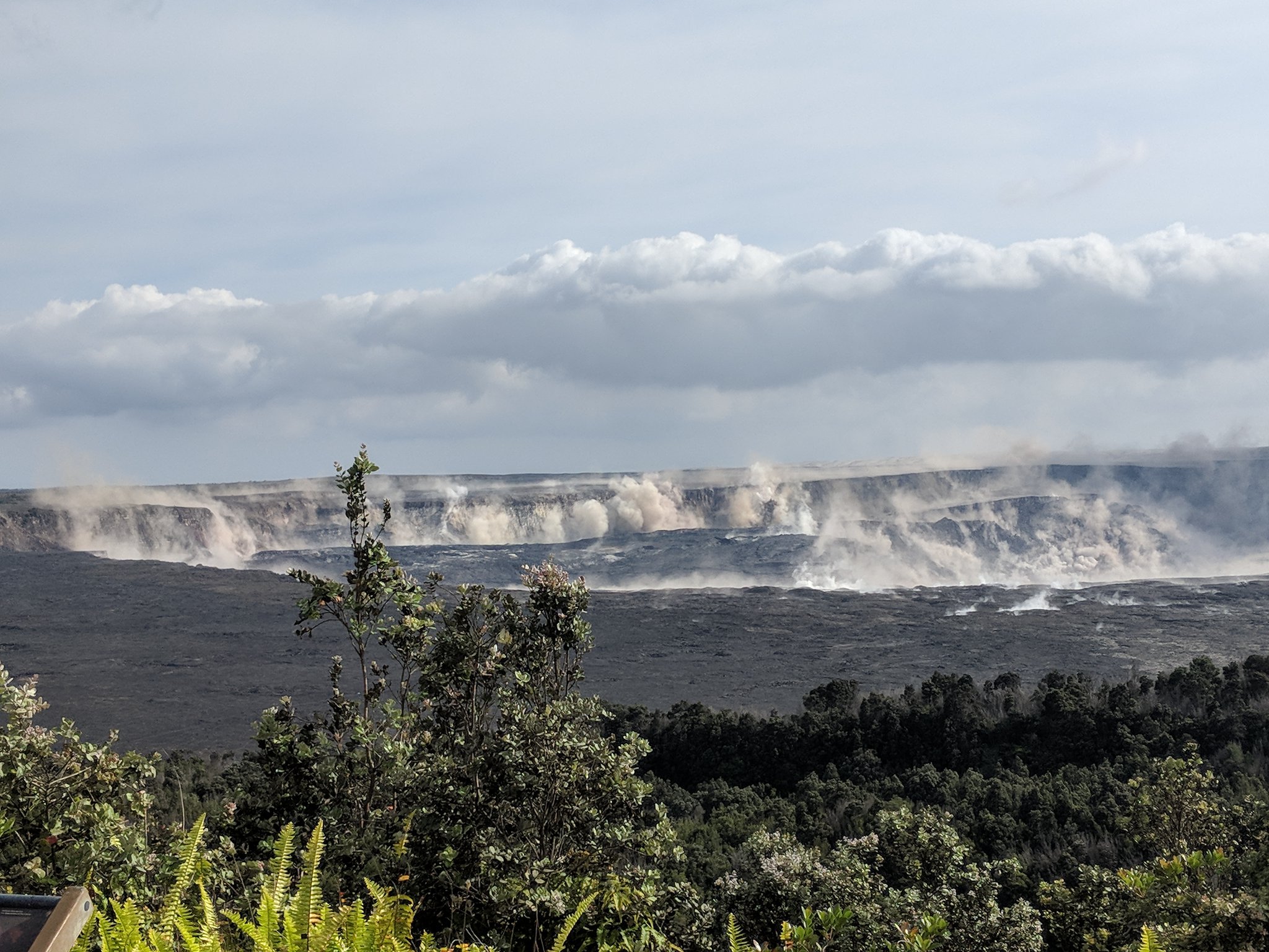
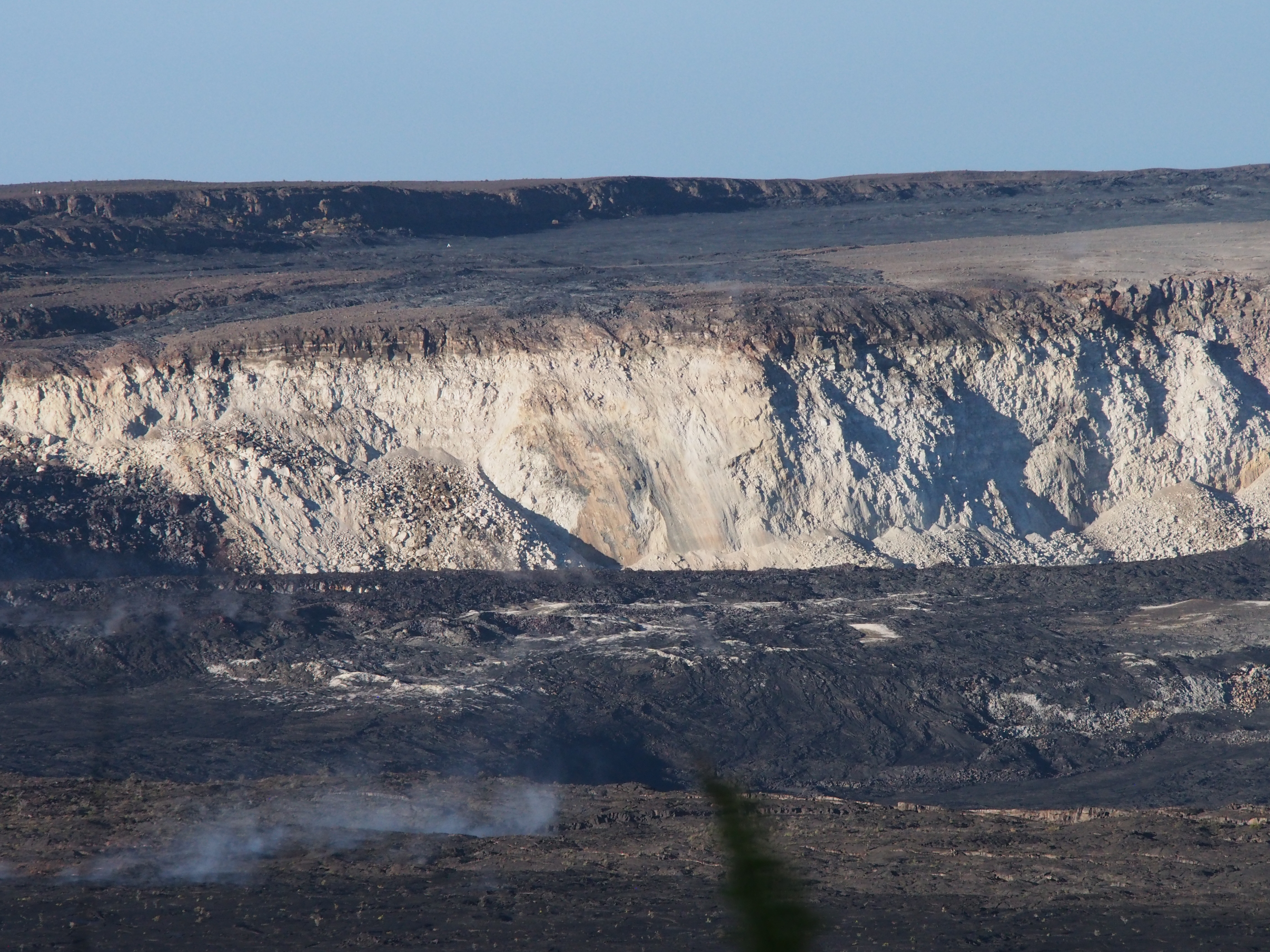
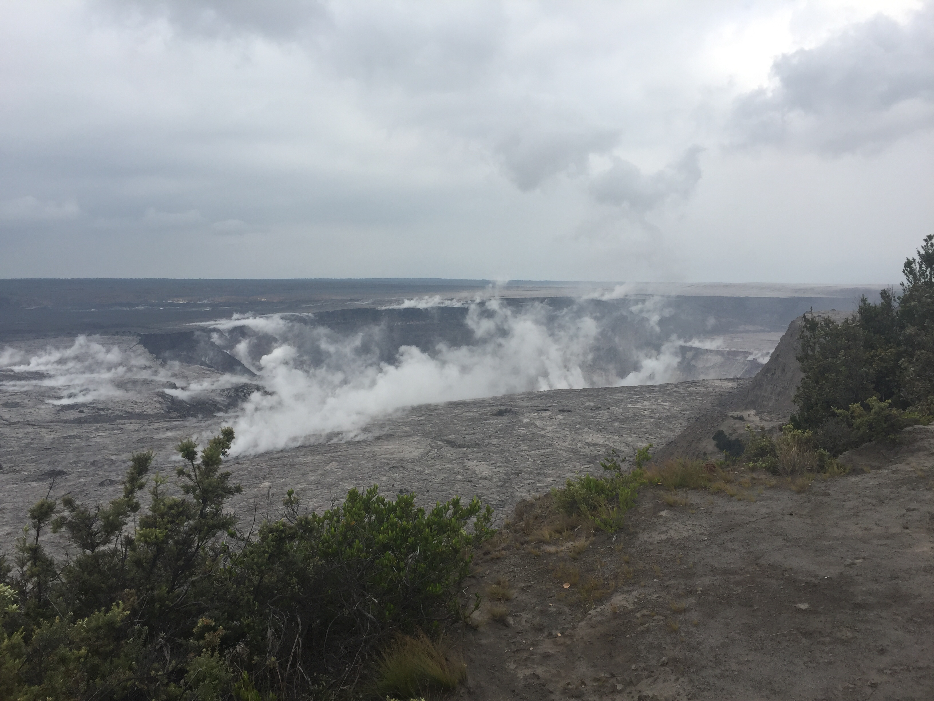
July 29, 2018. USGS: “This aerial view of Kīlauea’s summit (taken early yesterday morning, looking south) shows some well-known features and some that are now more obvious as a result of ongoing collapse of Halema‘uma‘u and parts of the summit caldera floor. Crater Rim Drive (lower right) leads to the USGS Hawaiian Volcano Observatory and NPS Jaggar Museum (right, middle), perched on the caldera rim and overlooking the growing Halema‘uma‘u. Ground cracks, parallel to the crater rim, are visible on the north side of Halema‘uma‘u (left side of image—also see our July 28 photo). South Sulphur Bank stands out as the light-colored area on the opposite crater wall (see our July 22 photo for a closer view of this feature).” (Full-sized)
The scientists of HVO had to abandon their 100-year-old observatory on the caldera rim mid-May. During the summer session, the University of Hilo was able to provide them with plenty of space for a temporary HQ. With fall term around the corner, HVO has leased part of the U.S. Customs Building in Hilo while they seek a more permanent solution. Because if and when the summit stabilizes, the old observatory will have to be rebuilt, or at the very least, will require massive repairs.
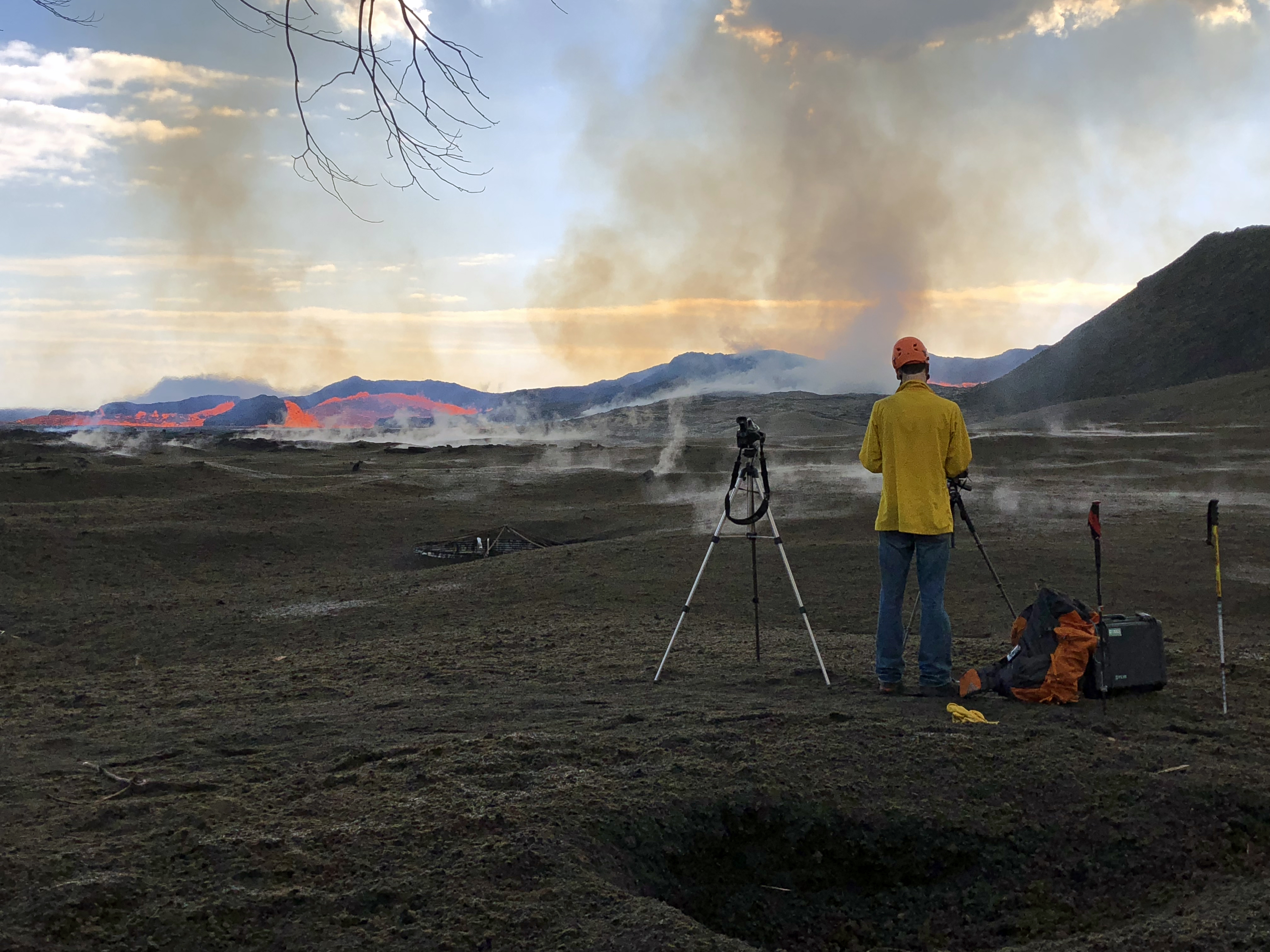
Speaking of the summit, today’s collapse event was at 12:10 pm, energy equivalent of M5.4. I captured the rockfalls 3-4 minutes before, as well as the actual summit collapse:
The clock on the Northeast Caldera Rim livestream is about a minute fast, but it’s so tiny you can’t see it anyway. The actual collapse starts about 1:30 into this video:
No changes on the Lower East Rift Zone eruption today.
Here’s the other HVO images for July 29 (as usual, I’m mirroring them because the HVO “Photo and Video Chronology” page only shows the 20 most recent entries, making images older than two weeks somewhat inaccessible.)
Janet Babb, Kīlauea Update: Good afternoon, everyone.
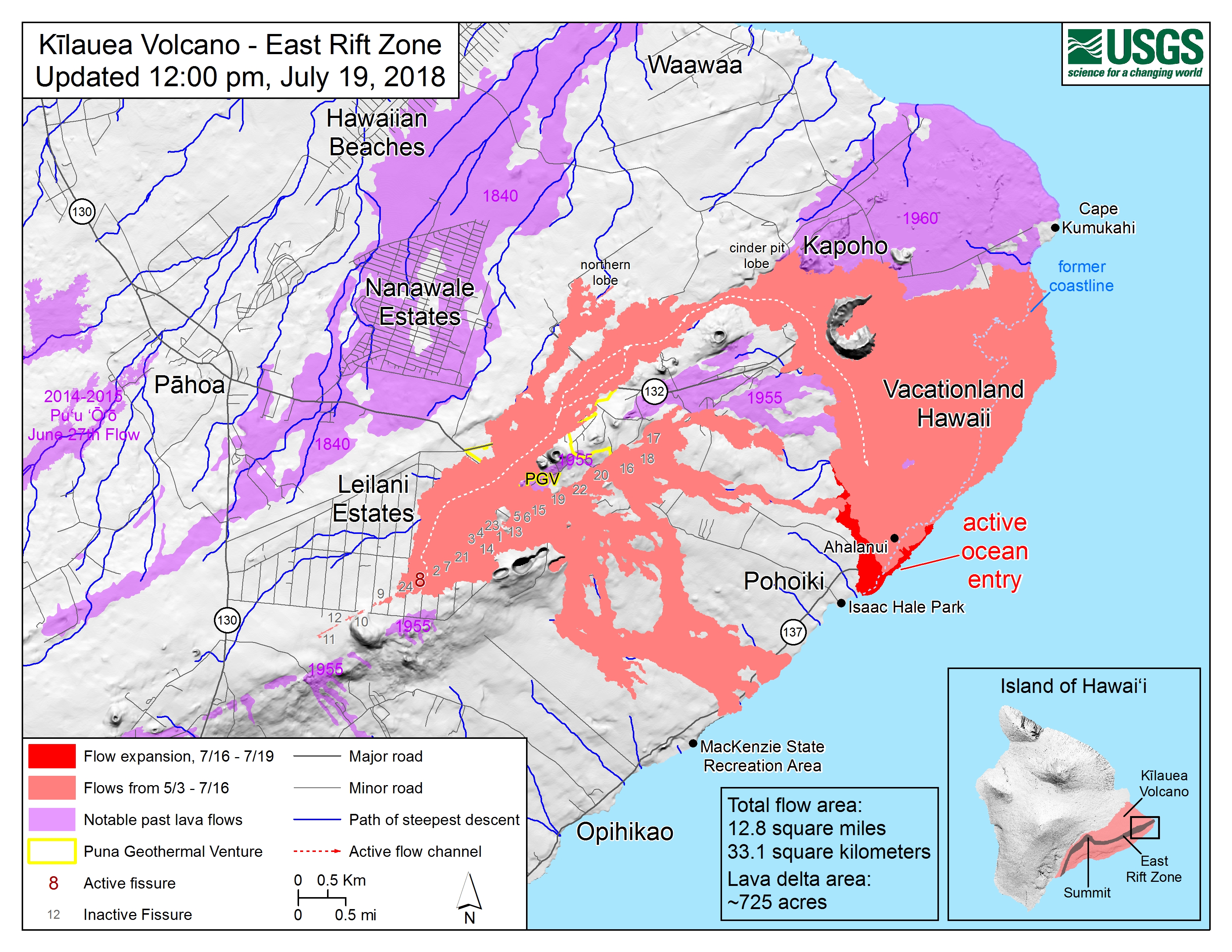
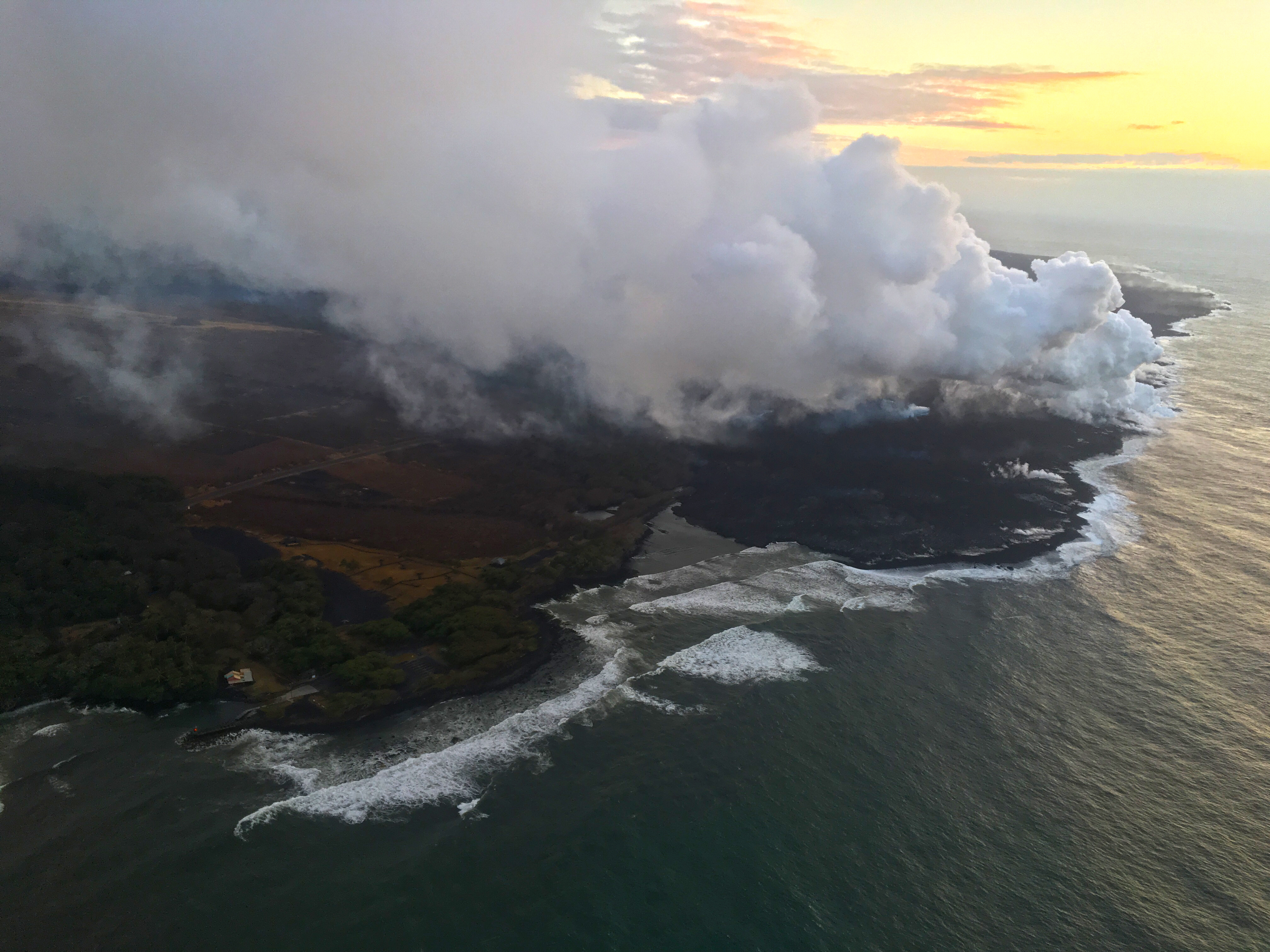
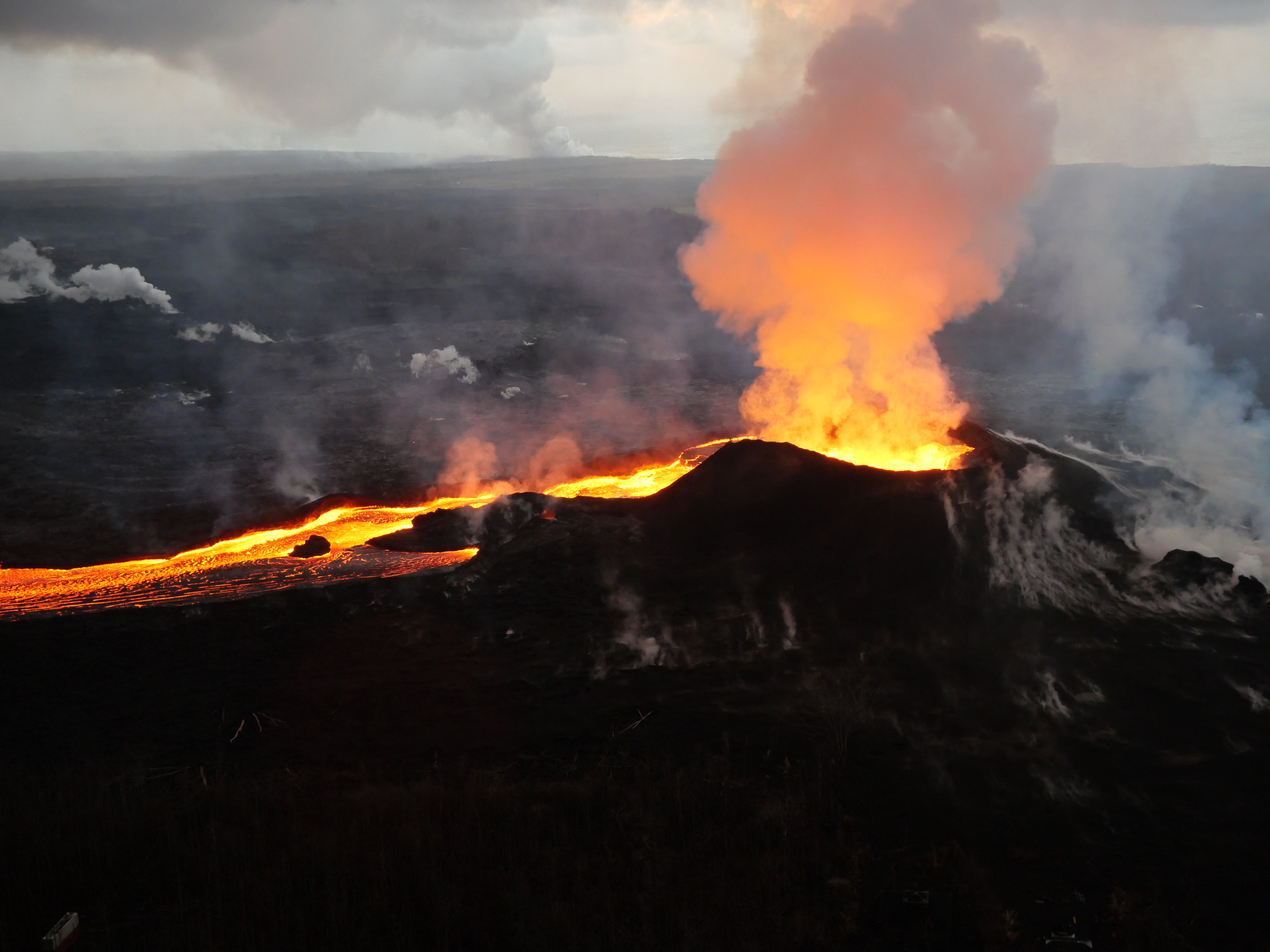
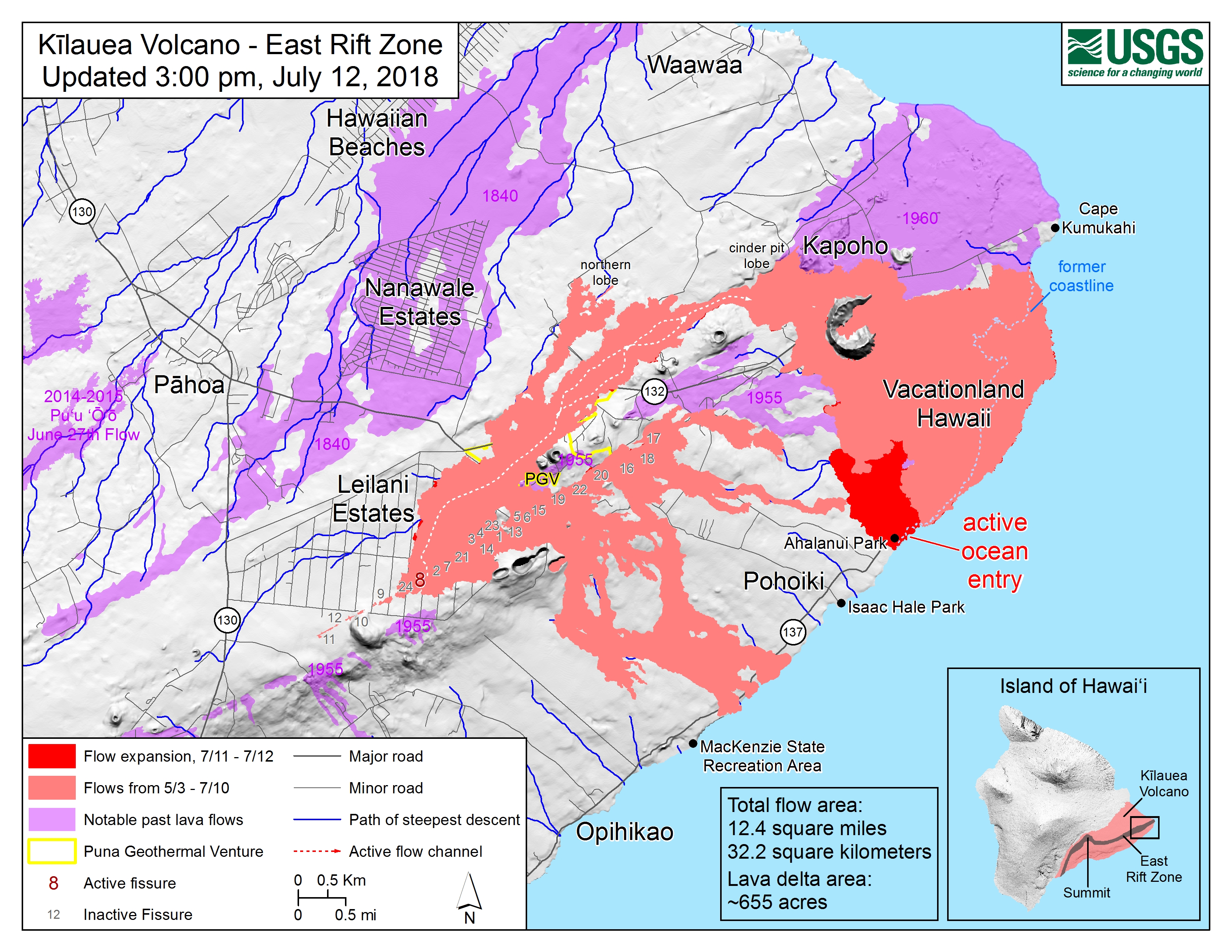
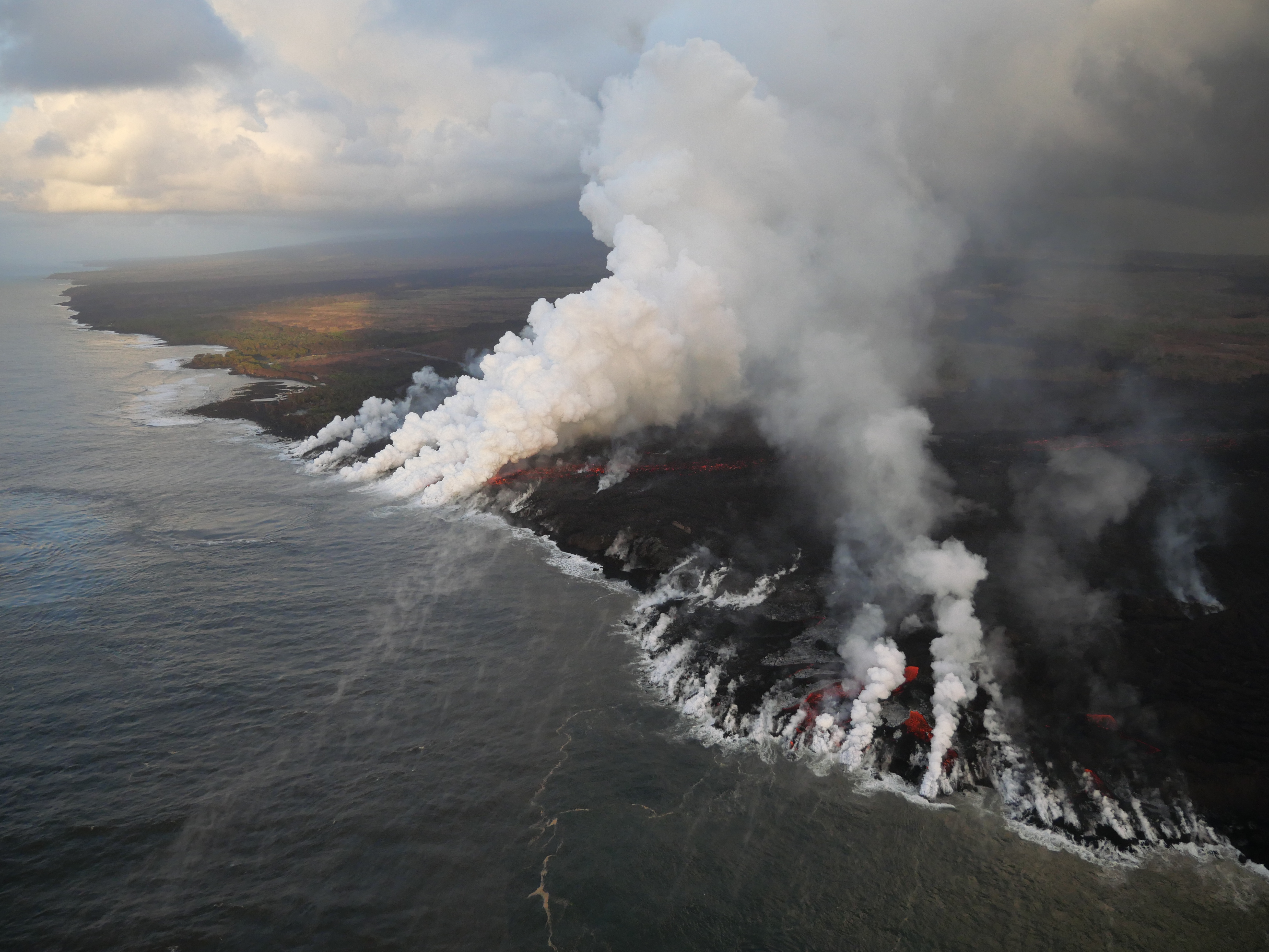
On the Lower East Rift Zone, Fissure 8 is still active. It continues to erupt lava into the perched channel that extends down on the west side of Kapoho Crater and feeds lava into the ocean. This morning, the main ocean entry was a little bit west of Ahalanui, with the flow margin about 500 meters, or 0.3 mile, from the Pohoiki boat ramp. There’s still some weak ocean entry points to the north of this main entry over near the Kapoho Bay lobe of lava where there were some weak, wispy plumes there. The flow front along the ocean, along the coast is still about 6 kilometers wide or 3.7 miles wide. On the Lower East Rift Zone, the sulfur dioxide emissions remain high, and the ocean entry hazards include the laze plume, as well as the possible hydrovolcanic explosions, what we referred to on Monday as “littoral explosions.” Hydrovolcanic is a little more intuitive word to explain the lava-seawater interaction.
Up at the summit, as we speak earthquakes are occurring at a rate of about 25-30 per hour as the volcano builds up to the next collapse event [this phonecall at 1 pm, collapse came at 4:33 pm.] The previous collapse event weas at 1:28 am July 18, so it’s been about 36 hours. We are within that time interval where we typically see these collapses occur. At the summit, the sulfur dioxide emissions are low. We’ll be posting some new photos and a new map shortly after this media call. That’s all.
July 19, 2018. USGS: “Volcanic gases rising from the fissure 8 vent and lava channel feed a pyrocumulonimbus cloud above the tephra cone. Small pits in the tephra deposit (foreground) form when the lava fragments collapse into cracks and void spaces below the surface.” (Full-sized)
Today’s Eruption Summary
As per usual. Fissure 8 continues to feed the lava channel down to the ocean, where the southern margin of the flow was 500 m from Isaac Hale Park this morning. Lava levels in the channel this morning were low, with the previous collapse event coming at 1:28 am the day before.
July 19, 2018. USGS: “An aerial view looking south, with the fissure 8 lava channel on the west side of Kapoho Crater, visible at left. As it nears the ocean, the channelized lava transitions to a broad ‘a‘ā flow that spreads laterally and toward the coast. The ocean entry plume is barely visible in the far distance (top).” (Full-sized)
Today’s summit collapse event occurred at 4:33 pm.
July 19, 2018. Collapse event tweeted by USGS: “Hereʻs a photograph from the 4:33PM #TypeA collapse event from #Kilauea summit. Rockfalls occurred from near-vertical cliffs around the #caldera and #Halemaumau.” (Full-sized)
WHT: “Fire sparked during RIMPAC exercises consumes 2,000 acres” – As I suspected. Those fires on the saddle between Mauna Loa and Mauna Kea which prompted the usual “Is Mauna Loa erupting?” questions were started by military training exercises.
Mick Kalber Overflights
Mick posted yesterday’s June 18 overflight (good views, including that lava flow moving over a still-active but slower flow) and notes as well as today’s:
Q: [Is Cape Kumakahi still the easternmost point of the island?] USGS: The area off Kapoho has a paltry supply of lava now – unless significant lava returns, the eastward advancement may cease.
Q: [Has there been any change in temperature of lava, now that it’s crusting over and/or not a fluid channel all the way to the ocean? Any sign eruption is ending?] USGS: No, the temperature remains the same. Other factors are probably responsible for the crusting – blockages, flow velocity, precipitation, etc. Sometimes the channels remain fluid, and sometimes the surface can crust over – but that doesn’t mean there isn’t lava moving beneath the crust… No, no signs that the eruption is ending yet.
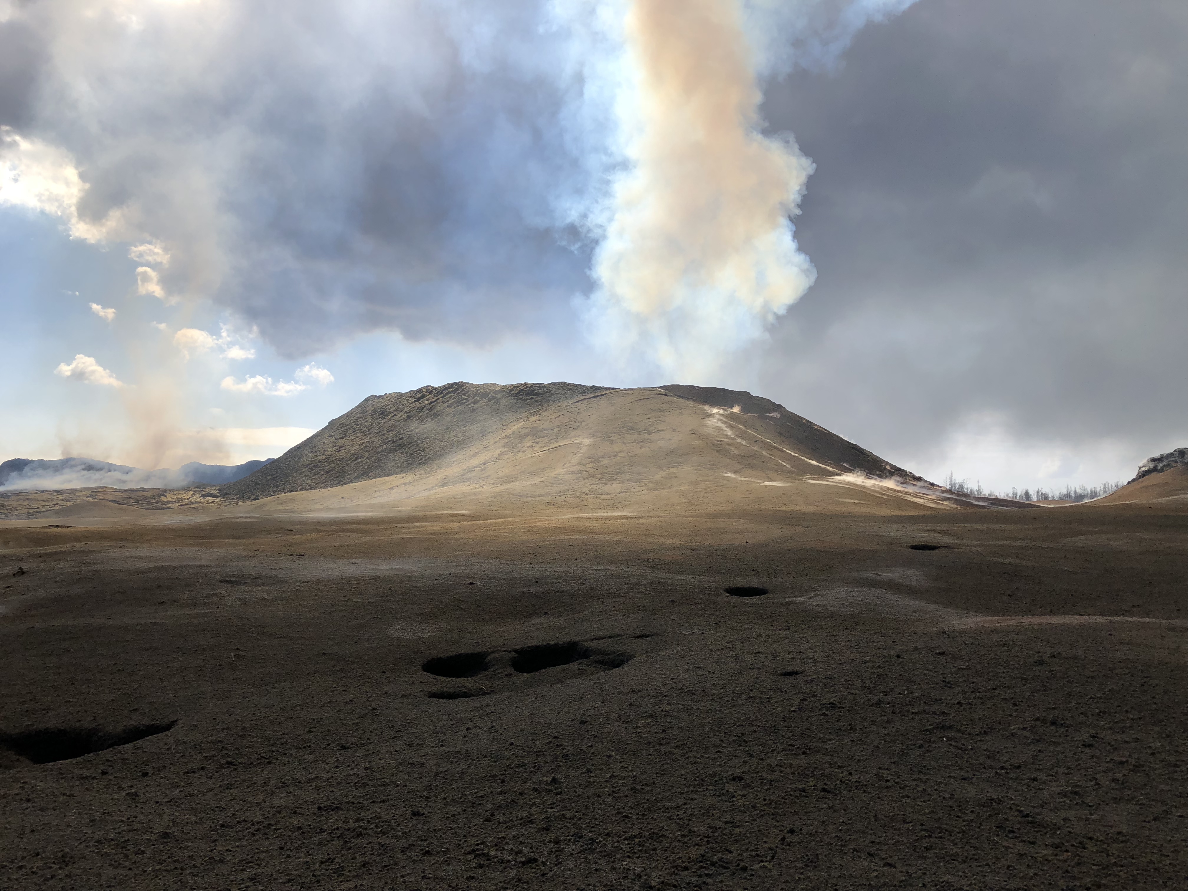
July 19, 2018. USGS: “his HVO geologist is standing on tephra (airborne lava fragments, such as Pele’s hair) that was erupted from and deposited downwind of the fissure 8 vent. He was there to observe the vent activity and to capture both thermal and video imagery of the pulsations occurring in the near-vent channel. The frame of a water catchment tank cover can be seen in the tephra deposit to the left of the geologist’s camera and tripod (center).” (Full-sized)
Q: [Someone asking about webcams and livestreams] USGS: We weren’t able to adjust the bandwidth on the cam from HVO, but we did add the stream from the northeast caldera, which uses a different (and still challenged) connection.
July 19, 2018. USGS: “Numerous rockfalls have occurred within Halema‘uma‘u and along Kīlauea’s summit caldera walls today, stirring up existing ash deposits and rock dust, and creating sounds that, at times, could be heard from the northeast rim of the caldera.” (Full-sized)
Q: [Cinder cone is 120 feet now? Was 180; has it collapsed?] USGS: Some settling has occurred, and some of the more precarious bits have probably fallen in or down the slopes. [Same basic question, different day] USGS: Yes it has succumbed to thermal erosion, collapse, and settling. There have been no sustained fountains depositing material on its outer slopes for several weeks, so there has been no additional accumulation of tephra.
Vladimir Vysotsky on FB: USGS Volcanoes: you keep characterizing this as a “perched channel”. I wonder if that is how lava tubes form – a channel builds the foundation and walls around itself, then crusts over while still flowing inside, and eventually forms a tube when the lava finally drains. Is that a correct assumption?
USGS Volcanoes: That is a very accurate description of lava tube formation! ][…] Hereʻs a video from Hawai’i Volcanoes National Park describing what you d[id] with video footage to accompany for visual reference. https://www.nps.gov/media/video/view.htm...
Q: [Is Fissure 8 how Diamond Head formed?] USGS: – Diamond Head is a tuff cone that erupted through water. It is also considered “rejuvenation stage” volcanism. The eruption that formed it occurred after the Koʻolau Volcano (from where it erupted) had been dormant for about 2 million years! http://volcano.oregonstate.edu/post-erosional-rejuvenation
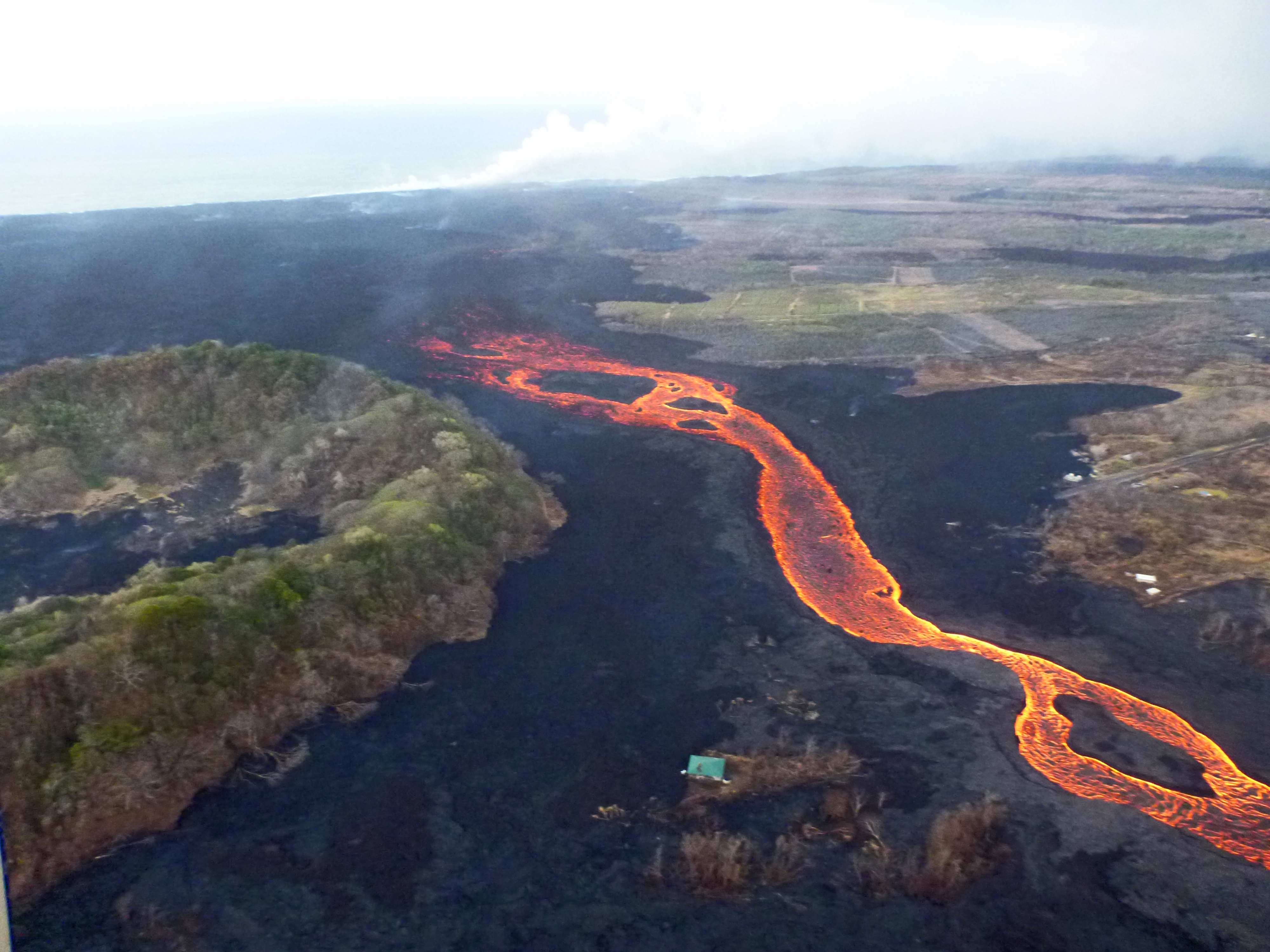
July 19, 2018. USGS: ” An aerial view looking to the west, near the braided section of the fissure 8 lava channel. During this morning’s overflight, the channelized lava was at a lower level than usual, but was still being fed by vigorous outflow from the vent.” (Full-sized)
Q: [How long will this go? How will it end? Does a lava flow normally start slowing down and then stop?] USGS: This could go on for any number of days, honestly. Typically these things don’t just turn off and stay turned off. We expect that activity in Fissure 8 will wane, then stop and start again (perhaps at other fissures). However, the eruption won’t stop all together until the pressure driving the magma out of the ground has been relieved.
Q: [How deep is lava channel?] USGS: We have tried to calculate depths based upon lava-flow observations within the channel and known depths of dormant channels on other locations in the Hawaiian islands. The channel is meters in depth, but likely not more than 10. Depth varies throughout its length as well.
[In discussion that Fissure 8 is not a volcano— it’s a vent on Kilauea’s flank just like Puʻu ʻŌʻō was, with magma being piped down from Kīlauea’s magma storage system— someone brought up Lō‘ihi, which IS a new volcano (or seamount) off SE coast of Big Island, still underwater.]
July 19, 2018. USGS: “As of this morning, the southern margin of the fissure 8 ocean entry was about 500 m (0.3 mi) from the boat ramp at Isaac Hale Park.” (Full-sized)
Q: [Is the summit caldera sitting on the magma chamber?] USGS: The subsidence area within the caldera essentially overlies the area of the shallow magma storage region that fed the lava lake in Halemaʻumaʻu. So, yes. Q: [Could the floor collapse into the chamber? What would happen then?] USGS: Technically speaking, the floor, and everything that was between it and the top of the chamber, is collapsing into it. Youʻre seeing the outcome – pressure drops and collapse events that manifest as M5.3 earthquakes.
Things too obscure to bug USGS about: why is it “littoral” when the Latin word for seashore has only one “t”? [Checks etymology: ah, yes, it’s a Medieval Latin spelling.)
July 14, 2018. USGS: ” Early morning view of fissure 8 and lava channel looking toward the east. Laze plume from the ocean entry is visible in distance (left of the fissure 8 plume). Geologists did not observe activity from any of the other fissures during this morning’s overflight.” (Full-sized)
Today’s Eruption Summary
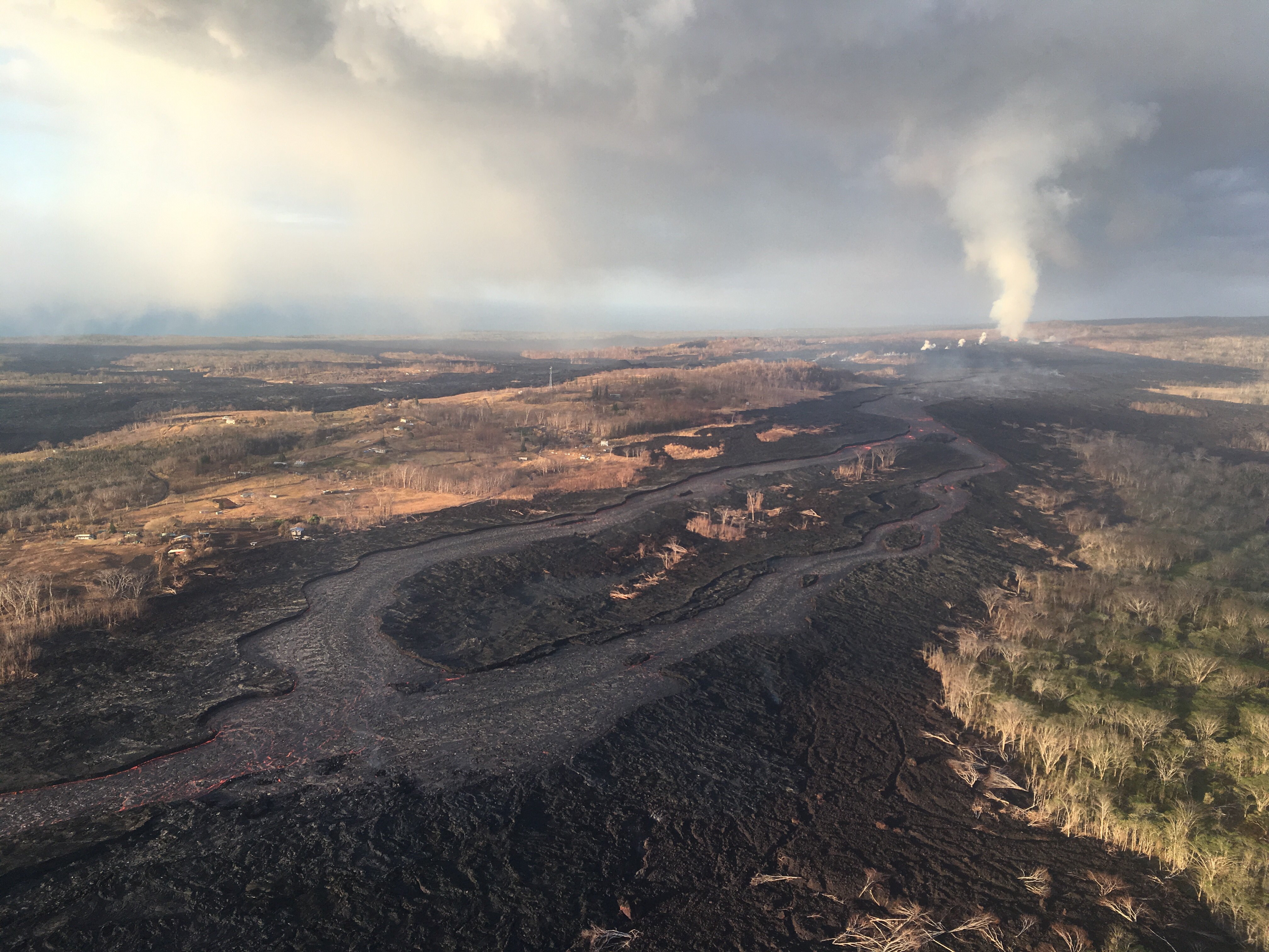
The Lower East Rift Zone eruption has settled back into a routine. Unfortunately, that routine includes the far end of Fissure 8’s lava flow crawling south along the coast, eating landmarks in its path. Isaac Hale Park/Pohoiki boat ramp (see flow map) is next in line. The morning USGS overflight reported that the flow front was about 1km away.
Friday evening, July 13, 2018, 6:00 pm – Kilauea's east rift zone overflight: Lava continues to pour into the sea at…
Fissure 8 continues to erupt into its perched channel, with its volume surging after yesterday’s 7:08pm summit collapse (Mag 5.3) and returning to lower levels by morning. That pulse caused a brief overflow on the east/southeast of the channel a short way downstream from the vent, but it stayed on the apron of previous flows.
The channelized a’a flow west of Kapoho Crater continues to be the main conduit to the ocean and to the active flow expanding southwards along the shore. North of this, lava continues to “ooze out” at various points along the June-early July flow front, whose length now totals 6km (3.7 miles).
July 14, 2018. USGS: “White laze plumes mark locations where lava enters the ocean over a broad area. An open lava channel flows into the ocean at the southern-most plume (middle) near the southern flow margin. The boat ramp at Pohoiki is about 940 m (0.58 mi) farther south of the flow margin. View is toward the west-southwest.” (Full-sized)
While there’s no sign of activity at any fissures besides 8, the tiny island that popped up just offshore of Kapoho yesterday is still there for now.
Mike Zoellner, geologist, Center for the Study of Active Volcanoes, UHI
Transcript – July 11 Eruption Update
Janet Babb, USGS: On the Lower East Rift Zone, Fissure 8 continues to erupt, and overnight the channelized flow that was diverted from the main channel that went west of Kapoho Crater advanced to the ocean, and, unfortunately, in its path, it destroyed the Kua O Ko La Charter School and the Ahalanui Beach Park area. And there’s now a new, very robust ocean entry plume near the Ahalanui Beach Park area. So in all, the flow front at the ocean now is about 3.7 miles wide.
In this morning’s overflight, there were no other fissures that appeared to be active.
At the summit, following yesterday’s early morning collapse/explosion that released energy equivalent to a magnitude 5.3 earthquake, the earthquakes have resumed— there was a period of quiet, but the earthquakes have resumed and currently the summit area is experiencing about 25-30 earthquakes per hour. This pattern is expected to continue.
As far as gas emissions at the summit, the gas emissions remain low, and on the Lower East Rift Zone, the gas emissions remain high. And with that, of course, the problems with vog continue with those high emissions.
Tina Neal, HVO: Good morning, everyone. Just to give you an update on what’s going on at Kilauea Volcano. In the Lower East Rift Zone, the effusive eruption of lava continues with little significant change from the last few days. The Fissure 8 spatter cone continues to produce a pretty vigorous river of lava in an open channel that heads to the northeast and then turns southeast, then enters the ocean about 8 miles downflow.
One of the interesting things observed by our field crews during the overflight this morning is that the channel system in the lower portion of this lava flow where it ends up into the ocean has gone through some changes. And this is an interesting phenomenon, reorganization, that we’re trying to understand. It appears at times that the channel is very vigorous all the way to the ocean, and at other times it sort of diminishes and just becomes a broad, rubbly front. As of this morning, the channel was mostly on the southern side of the flow, and the margin of the flow is expanding a little bit to the south. So there’s some very interesting channel dynamics going on in this lava flow in the lower portion that really doesn’t [act??] its behavior as it spreads out and enters the ocean.
Between computer troubles (fixed now!) and that all-important Volcano Village meeting last Thursday evening, I missed the July 5 11am USGS media conference call. Here’s the archived audio file.
It was short, but for completeness’ sake, here’s a transcript.
[Note: Posted July 9, 3.30pm HST, backdated to keep it in correct order chronologically.]
This is my transcript of the July 2, 2018 11am USGS press briefing, which covered lava-created thunderstorms, whirlwinds, and rain; laze-induced lightning; and lava boats. Additionally, Mike Zoellner mentioned findings of a sonar expedition to measure the lava extending on the ocean floor.
Soundfile is archived here. BigIslandVideoNews has also posted most of it, overlaid with recent video footage:
Participants:
Leslie Gordon, USGS Public Affairs
Jessica Ferracane, Hawaii Volcanoes Nat’l Park Public Affairs
Robert Ballard, NWS
Mike Zoeller, HVO & Center for the Study of Active Volcanoes, UHI
Brian Shiro, seismologist, USGS/HVO
Transcript note: I omit salutations/pleasantries, jumping straight to news and information. Also I usually summarize questions to provide just enough context for USGS responses.
USGS: “The USGS UAS (unoccupied aircraft system) team took this photograph of Halema‘uma‘u Crater from the Kīlauea Overlook on this morning. They are preparing for a flight to map further subsidence at the summit.” (Full-sized)
Summary:
Update: Status quo at Fissure 8, LERZ, Summit. New “tidbit”: front of lava is sitting on ocean floor that was 60 meters deep. Also, using term “collapse explosion” for daily explosions, because not 100% clear whether explosion triggers collapse or vice versa. Tradewinds and showers through weekend.
Questions & answers:
Q: Possibility of new fissures opening, or if not, why not? Has seismicity in LERZ decreased? A: Not ruling it out, but magma has found a good conduit to Fissure 8, seems stable. Seismicity in LERZ “pretty quiet.”
Leslie Gordon, USGS Public Affairs: That will not affect what we’re doing here at Kilauea. I think the department realizes that this is an urgent situation. We have people’s livelihoods endangered. People have lost their homes and businesses. And so we— it will not affect what we’re doing here regarding Kilauea Volcano.
3. Q: Do you think it’s safe local residents to view lava if they’re outside mandatory evacuation zone? A: Not our call. It’s up to Hawaii County.
4. Q: What’s process for naming fissure 8? A: Hawaiian elders, community, Board on Geographic Names decide when and what to call places in Hawaii.
5. Q: Will delta collapse? How far out? A: Can’t rule out collapse, but it’s on fairly stable slope so far; 100-200 meters from where it is now the slope steepens. [Didn’t say what would happen there, but I think implication is that it will be less stable and more collapse-prone.]


