Today’s Eruption Summary
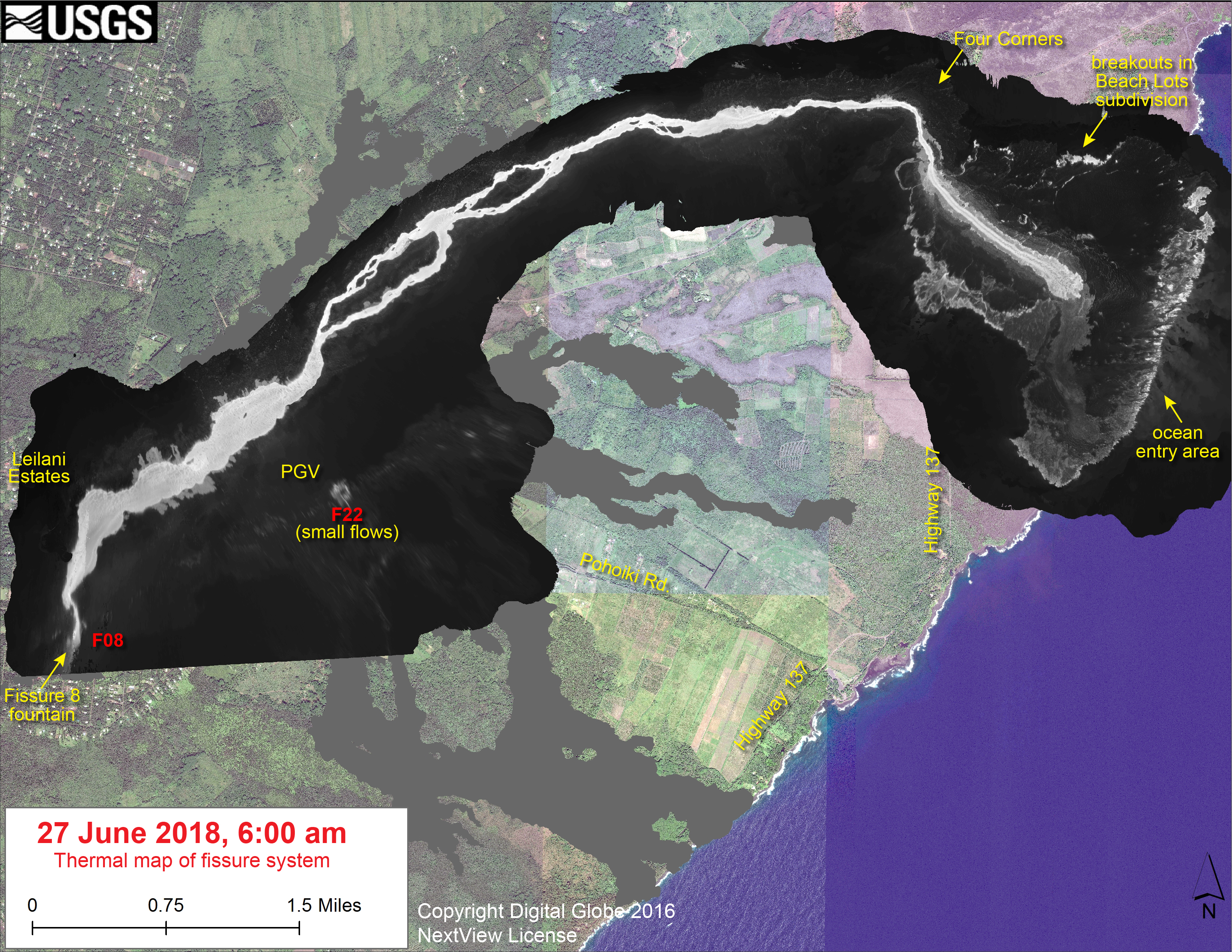
Fissure 8 and the summit explosions continue their status quo. However, for the last few days, the lava flow at Kapoho has been encroaching on new areas on its northern and southern boundaries at the coast.
At least 3 more Kapoho Beach Lot houses have burned on the north side, and the southern edge of the flow is burning vegetation and/or farmland west of Highway 137. I gather these new lateral outbreaks are due to the lava channel crusting over, about half a mile inland from the new coastline (see Wednesday’s thermal map). So instead of pouring straight from the channel into the ocean, lava is fanning out under the crust of the 2-mile-wide lava delta laid down earlier this month, then oozing out the sides.
[USGS drone footage of Fissure 8 from before dawn. They’re using drones for the first time to map flows, look for outbreaks and measure the lava river’s speed.]
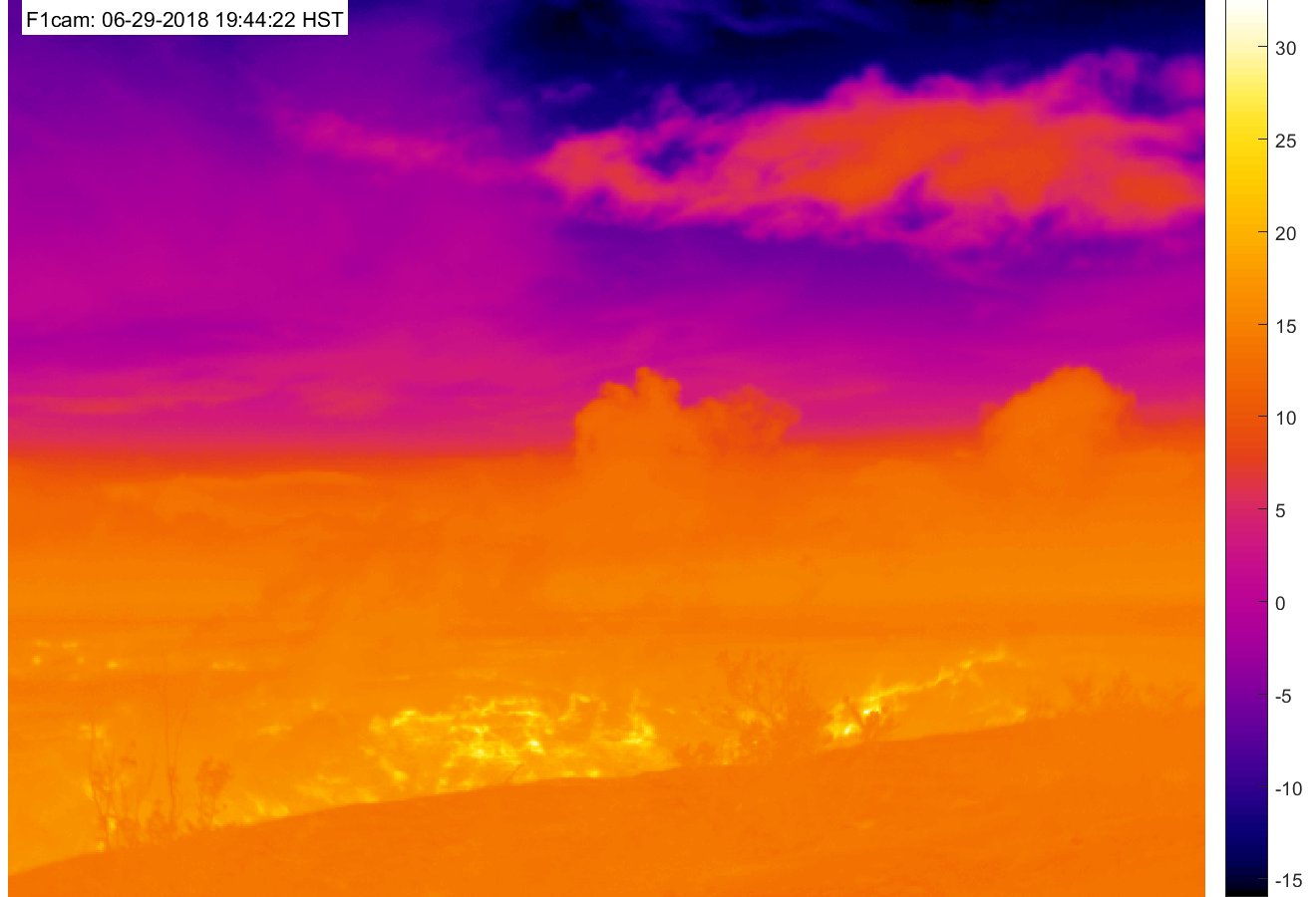
At Kilauea’s summit, today’s collapse explosion occurred at 7:51am HST, June 29, with an ash-poor steam plume that rose 500 feet. (Steam?)The energy release dropped slightly to 5.2. I didn’t do a video capture, since the summit was blanketed in morning fog.
The “new news” today is that HVO has added two new views to its Kilauea Webcams page. One I’ve mentioned before, the old “Kilauea East” webcam from HVO’s 1990s website which has annoying reflections but a great view of the subsidence/collapse on the east side of Halema’uma’u Crater:

The other is a new heat-sensitive webcam which should make it possible to see “collapse explosions” at night:
Also, in this week’s “Volcano Watch” newsletter, Hawaiian Volcano Observatory scientists explain the “piston” model they’ve developed to account for the daily collapse explosions at the summit:
What causes the collapse/explosion events at #Kilauea's summit? This week's #HVO #VolcanoWatch article explains…https://t.co/c9476EuTbE#halemaumau #KilaueaErupts #KilaueaEruption pic.twitter.com/ntMnky5Oy6
— USGS Volcanoes🌋 (@USGSVolcanoes) June 29, 2018
(See also the “Kilauea Earthquakes FAQ” they posted earlier this week.)
This is big news. They’ve solved the mystery of the summit explosions! Subject to revision, of course; they’re still untangling the complexities of Kilauea’s current eruption. But the “piston” model accounts for the cyclical pattern they’re seeing better than the “steam explosion” model.
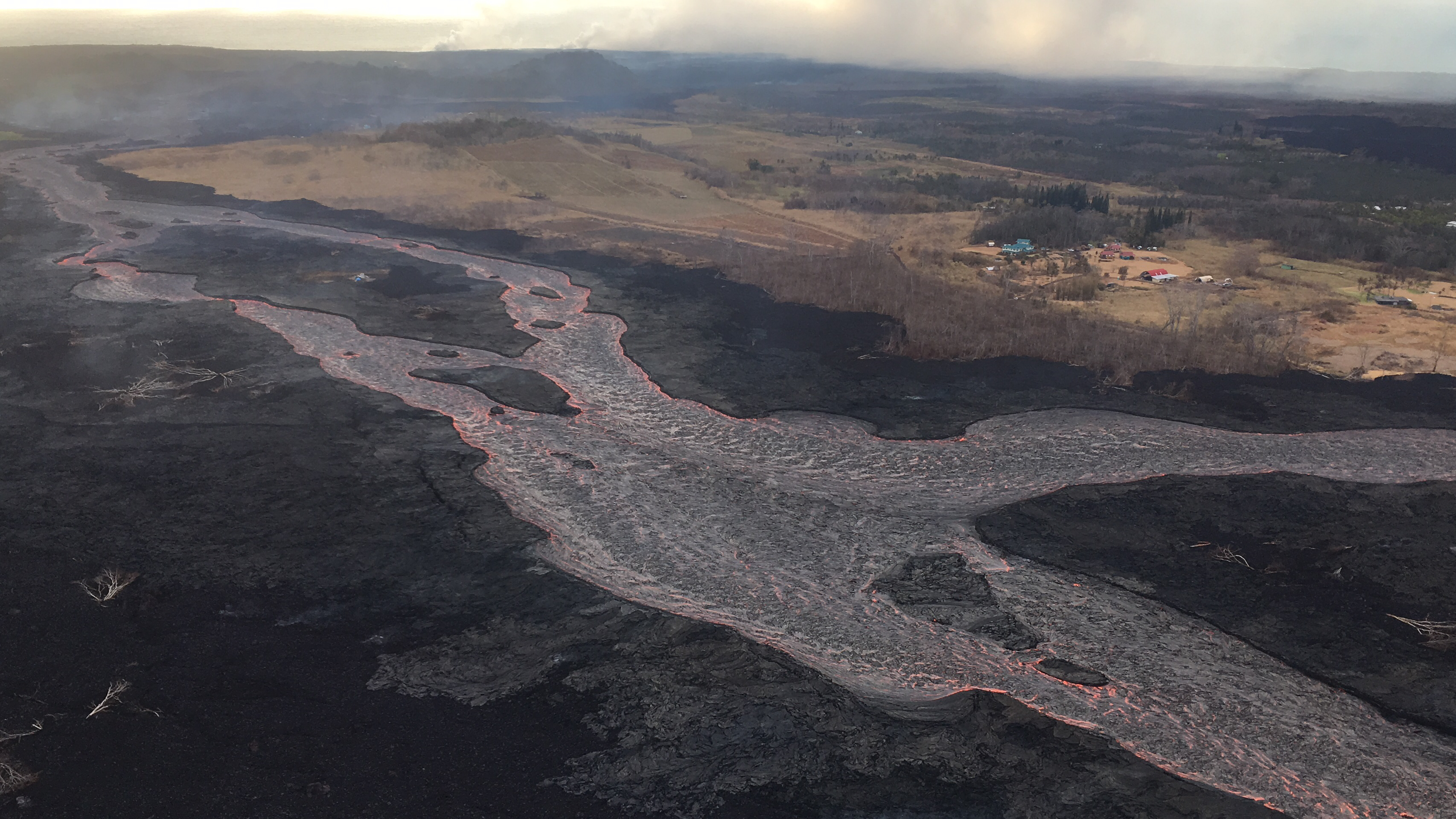
Mick Kalber Overflight
Sunrise flights are always so spectacular, when the lava’s glowing yet you can dimly see the land around it.
From Local News Media
- HTH: “Police: Persistent claims about looting are mostly just rumors”
- HTH: “Summit’s unprecedented change, volcanic activity to engross scientists for years to come”
- HSA: “Hawai’i Volcanoes National Park’s future ‘a huge unknown'”
- HSA: “Kilauea’s official toll of destroyed homes at 668 and rising”
- HTH: “Animal rescues continue in lava zones”
- HCB: “Big Island: Tallying The Growing Cost Of A Multimillion-Dollar Eruption”
- HSA: “Hirono pushing for bill that would assist farmers affected by Kilauea eruption”
- HNN: “Hawaii’s congressional delegation seeks maximum help for Big Island farmers”
- HCB: “Mental Health Is Another Casualty In The Ongoing Volcanic Eruption”
- HSA: “Russian visitor cited for loitering in lava zone and for flying drone”
- HNN: “Their lives turned upside down, lava evacuees learn the value of a clean shirt”
- HSA (Photos): “Leilani Estates evacuees say final farewell to homes“
Here’s a video of the Thursday evening Volcano Village community meeting with the USGS and National Park Service, discussing ongoing earthquakes and their impact on the park and village.
From Other Agencies
@USGSVolcanoes reports Pele's hair & other volcanic glass fragments from Fissure 8 continue to fall downwind, dusting ground w/in a few hundred meters of the vent. Minimize exposure w/ an N-95 mask, eye protection, long sleeves & pants to prevent harm to nose, eyes & skin. pic.twitter.com/vVWpA0clgm
— HI Dept of Health (@HIgov_Health) June 29, 2018
USGS Q&A on Social Media

Q: What’s the current estimated flow rate of Fissure 8?
USGS: Our last estimated flow rate (June 17) was ~1500 m3/s (almost 400,000 gallons/s), but that has likely changed in the past few weeks.
[GOOD GRIEF. The last figure I’d seen was 26,000 gallons/second, which was already astonishing!]
Q: Is this the longest eruption on record or has there been longer ones?
USGS: Kilauea has been a state of near-perpetual eruption for 35 years. It just switched locations in May.
[The HVO website’s “history & geology of Kilauea” page says the 60-year-long ‘Ailā‘au flow was the “longest-lasting lava flow witnessed by human inhabitants in Hawai‘i.” Astonishingly, a drained 40-mile-long lava tube still exists from this 500-year-old eruption.]
Q: Is this eruption’s eruption volume/rate the highest ever recorded?
USGS: The volume is impressive, and the eruption rates are pretty high, but Mauna Loa eruption rates are generally even higher. For example, only in the past couple of weeks has this eruption surpassed the volume of Mauna Loa’s 1984 eruption, but the 1984 activity lasted only 3 weeks!
Q: Why isn’t tephra falling here in Leilani Estates anymore? [Evacuation orders were lifted on the northwest side where there’s been no fissure activity.]
USGS: The lava fountains aren’t quite as high as they were about a month ago, but the cone is also much larger. Even if fountains do reach prior heights, most of the material is collected within the cone rather than being lofted downwind. The majority of the time, the fountain is barely reaching above the level of the cone.
Q: What’s burning west of 137?
USGS: Latest reports say that it’s near a papaya farm, although we don’t have details on the address.
Q: Do the duration of 1840, 1955 and 1960 lava flows in same area give some indication about the duration of this one?
USGS: They give us a potential timeframe – weeks to months – but no guarantee. Given the current robust output of fissure 8, it doesn’t appear that it will stop in the immediate future.
Q: How does a lava tube form?
USGS: Lava tubes come from the crusting-over of lava channels like this one. Sometimes levees build up to the point where they overhang the channel, allowing larger blocks to get stuck and form a roof; other times the channel flow slows and forms a thick skin. https://volcanoes.usgs.gov/vsc/glossary/lava_tube.html
Q: Do you see any kind of “surge” in the lava effusion rate at Fissure 8 following one of the summit collapse events?
USGS: Good question! We’ve looked for this, because we do see subtle tilt signals out near Pu`u `O`o that correlate in time with the collapse events (they lag in time a little, as one might expect). This suggests that there is some sort of pulse coming through the rift zone, although we aren’t sure if it is a pressure wave or some sort of magma surge. Regardless, we haven’t noticed any changes in effusion rate at Fissure 8 that might correspond. If there is a pulse, it might get smeared out over the ~25 miles of conduit so that by the time it reached Fissure 8 it was not resolvable.
#Kilauea lava keeps on flowing into the ocean creating steam clouds (image from 22 June) that #Sentinel2 optical sensors cannot penetrate. But we have #Sentinel1 superpowers!
Wait for our next tweet to see them in action… pic.twitter.com/GmOe7vH0og— ESA EarthObservation (@ESA_EO) June 29, 2018
Q: Is any of the magma drained from the summit erupting in the Lower East Rift Zone?
USGS: The magma at the rift zones is “summit like” but is not 100% summit composition. The chemical signature and composition of crystals in the magma tell us that it originated from a primitive source and probably from within the rift zone. There is a lot of space for magma to be stored in the East Rift Zone – not to mention, the large space that was opened as a result of the 6.9 earthquake sequence. The pressure regime within the magma storage and transport regions has changed, and magma is probably filling in less pressurized void space. We do know that when Pu‘u ‘Ō‘ō drained, the magma moved into the lower East Rift Zone – that would have been ahead of summit magma.
Q: How do volcanologists collect lava from a lava lake to analyze?
USGS: When the lava lake was present, some of the explosive events produced what we call “juvenile tephra”. This was material ejected upward from the surface of the lava lake during rock-fall induced explosions. Geologists placed a series of buckets on the caldera floor, downwind of the Overlook vent and Halema’uma’u. Each day, the buckets were swept clean and tephra (deposited ash/rocks) analyzed. After explosive events, that tephra included bits of juvenile material from the lava lake as well as bits of crater wall rock.
Q: Are the rocks falling into the chimney of the former lava lake going down into the magma chamber, remelting, and heading down into the East Rift Zone?
USGS: It’s hard to know how things work in a magmatic system like this without direct observation, but we suspect that rocks falling into magma and being remelted won’t be a major process. Magma chambers tend to not be giant balls of molten material, but rather interconnected areas of melt with mushy, cooler zones in between. That makes the geometry more complex, and less likely that pieces of roof material would easily be incorporated into the magmatic system.
Q: Is the shallow magma reservoir under Halema’uma’u draining, not just the conduit that held the lava lake?
USGS: Yes, the shallow reservoir is what has been draining, not just the magma that was sitting in the conduit. We think that the collapses involve what remains of the conduit as well as the upper portions of the shallow reservoir, but we’re not sure yet.
Q: What does the shallow magma reservoir under Halema’uma’u look like? Not actually a big round chamber, right?
USGS: Yes, that’s more of an illustration that we use in schematic (simplified) diagrams. In reality, it might look more like a series of interconnected sills and dikes (essentially horizontal and vertical discs of magma).
Q: What happens if the shallow magma chamber [under Halema’uma’u] repressurized? Would a larger lava lake appear? And what happens if the larger summit magma chamber [the larger, slightly deeperone under the caldera] depressurizes too?
USGS: For your first question, we suspect we would see an expanded lava lake. That’s what happened back in the 1800s. The caldera was much deeper then, and it gradually refilled with lava. There would be some uplift — it’s not clear how much — but a lava lake would probably also be active. On your second question, the two reservoirs are connected, as is the entire plumbing system, so the pressure in both is low right now. If the deeper reservoir were to depressurize significantly, the subsidence might broaden, but we aren’t seeing that to a huge degree at this point. There has been some subsidence caused by the deeper reservoir, but because it is deeper and larger, it can support more deprssurization with little noticeable affect at the surface (unlike the shallower, smaller reservoir).
#Kilauea #Caldera subsides in this timelapse of images.
View is from near #Keanakakoi Crater looking north toward #HVO and #JaggarMuseum in @Volcanoes_NPS. Northern part of caldera is not subsiding. https://t.co/oIEvfvO0AE pic.twitter.com/6KUWnnR0Rq
— USGS Volcanoes🌋 (@USGSVolcanoes) June 29, 2018
Q: What’s the depth the caldera has subsided?
USGS: At this point, the deepest part of the expanding Halema`uma`u crater is over 1500 feet, but the amount of subsidence varies tremendously across the caldera floor.
Q: Is HVO in danger of falling into the caldera?
USGS: For the moment, the rim of the bluff seems stable, but this is certainly something we are worried about given the proximity of the deepening crater to the caldera wall where HVO is located. We’re watching this pretty carefully.
Q: [The daily “Is Kilauea’s summit going to collapse catastrophically?” question— this one mentioned a “chasm” opening up in the mantle(!)]
USGS: What we’re observing is the collapse of a portion of the summit caldera. This is, in fact, a very good example of how many calderas form — they aren’t explosive features, like Yellowstone or Crater Lake, but rather form when magma drains out of subsurface reservoirs, and the ground above sinks into the evacuated space. The end result will be a nested crater system at the summit. And it will slow and stop eventually (we’re not sure when — the rate has been very consistent over the past several weeks). it is related to the lava eruption on the lower East Rift Zone, since that is the cause of the draining.
Regarding the pictures in the the following Tweet:
USGS: To pick out the slumping, concentrate on the dark, relatively fresh lava flow at the center of the image. It has downdropped considerably, and the bright area you mention is a slab of another lava flow that has fallen in because it has lost support.
#HVO #Kilauea Summit update (June 28): At 04:49AM HST after ~26 hours of elevated seismicity, collapse explosion w/energy = M5.3 EQ produced ash-poor steam plume that rose ~1,000 ft & drifted SW. Halema'uma'u rim and wall slumping continues. https://t.co/7sDZqcx8dU pic.twitter.com/7oVeAyHoWI
— USGS Volcanoes🌋 (@USGSVolcanoes) June 28, 2018
I keep noticing that whenever USGS scientists put in extra time and effort, even braving personal risk, to give the public new things, the response isn’t “thank you” but “give us more things”:
What about a mobile cam with a view of the current lava flows?
— Louis Epstein (@SensiblCentrist) June 29, 2018
USGS reply: “That would be interesting, but the USGS is a science agency, not a news organization. Our first priority is the scientific observations that we relay to @CivilDefenseHI to help keep people safe. We have a limited staff and can’t spend time setting up cameras just for viewing.”
From Photographers & Social Media
From Leilani Estates today, up close with Fissure 8. #LeilaniEstatesEruption #Kilauea #LeilaniEstates pic.twitter.com/EF3mRA1KY0
— Dane duPont (@GeoGolfHawaii) June 30, 2018
Bruce Omori photos from this morning:
Friday, June 29, 2018, 5:45 am – Kilauea's east rift zone overflight: Fissure 8 continue to discharge lava at an inordinate rate, feeding this channelized flow that leads to the sea.
Posted by Extreme Exposure Fine Art Gallery on Friday, June 29, 2018
Friday, June 29, 2018, 5:45 am – Kilauea's east rift zone overflight: A view looking back at the fissure, above the braided channel.
Posted by Extreme Exposure Fine Art Gallery on Friday, June 29, 2018
Friday, June 29, 2018, 5:45 am – Kilauea's east rift zone overflight: An incredible abstract created by this river of…
Posted by Extreme Exposure Fine Art Gallery on Friday, June 29, 2018
Friday, June 29, 2018, 5:45 am – Kilauea's east rift zone overflight: A view of the flow as it bends around Kapoho Crater. The river of lava has eroded into the surrounding lava, creating a deeper channel.
Posted by Extreme Exposure Fine Art Gallery on Friday, June 29, 2018
Friday, June 29, 2018, 5:45 am – Kilauea's east rift zone overflight: University Pond in Kapoho is no more, as lava fills it in, in the lower half of the photo.
Posted by Extreme Exposure Fine Art Gallery on Friday, June 29, 2018
Friday, June 29, 2018, 5:45 am – Kilauea's east rift zone overflight: A view of what remains of Kapoho ag and beach lots.
Posted by Extreme Exposure Fine Art Gallery on Friday, June 29, 2018
Friday, June 29, 2018, 5:45 am – Kilauea's east rift zone overflight: The blue house still stands… while a new flow has moved onto the street on the right.
Posted by Extreme Exposure Fine Art Gallery on Friday, June 29, 2018