June 28: USGS Talk on Latest Changes to Kilauea Caldera [Pt. 1 of 3]

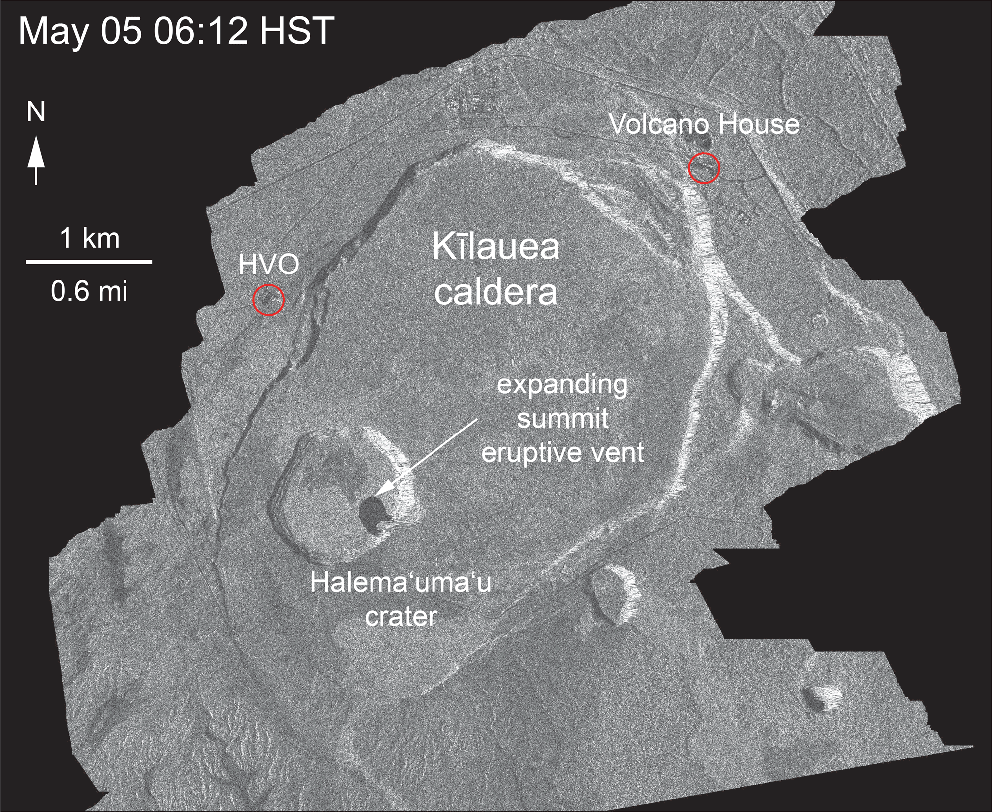
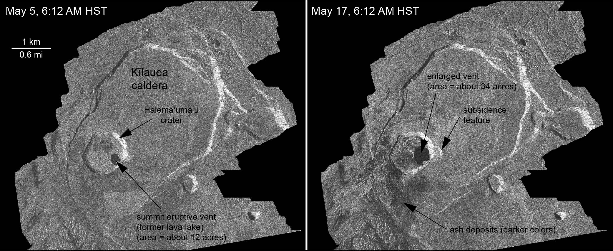
On Thursday, there was an hour and a half meeting with the USGS, National Park Service and residents of Volcano Village. Above is a video of the whole meeting. As usual, I’m interested in the geology, and so I’ve made a transcript of that part of the meeting. The first half of Kyle Anderson’s talk rehashes the “collapse/explosion” events that we’ve covered before, but the second half has a timelapse of Halema’uma’u from June 1st to June 28th — which I’ve rebuilt frame by frame, since I could just make out the timestamps— plus the latest Digital Elevation Model of Kilauea’s summit showing the slumping not only in Halema’uma’u, but across part of the caldera floor.

Scientist-in-Charge Tina Neal (HVO)

[5:40] [Introductory remarks, greetings and thanks]

[6:20] So tonight you’ll hear from familiar faces, Kyle Anderson and Don Swanson, who will give you an update on what the volcano is doing, what we think is happening, and we’ll touch on this very important question of how long and how big. Those are very hard questions to answer, so let me just preview that we’re not going to give you a wonderful take-away that will solve all that uncertainty. But we’ll do the best we can.

Continue reading June 28: USGS Talk on Latest Changes to Kilauea Caldera [Pt. 1 of 3]

Changes to Halema’uma’u Crater, Kilauea Summit

Before and after: Halema’uma’u in 1992 & 2018

Left:  November 1992, photo by Winston Brundige*
Right: Screengrab of HVO webcam on June 19, 2018


*used with permission. Thanks, Dad.

Before and after: May vs June 2018

Left: USGS photo from Volcano House, May 19, 2018
Right: USGS photo from Volcano House, June 13, 2018

  • Halemaʻumaʻu before this started: 1 km (0.6 mi) across, 85 m (~280 ft) deep.
  • Halema’uma’u Jun 15, 2018: 1 X 1.3 km (0.6 to 0.8 mi) dimensions, 370 m (1,210 ft) deep.
Radar Images, May 5-June 18

Thanks to the Italian Space Agency for taking a radar satellite image of Kilauea about once a week:

USGS: “May 5 and June 18 at about 6:00 a.m.[…]The last five images in the sequence, from May 29-June 18, show the development of several cracks outside Halema‘uma‘u (also seen in recent UAS footage of the crater) and inward slumping of a large portion of the western, southwestern, and northern crater rim. Much of this motion appears to be coincident with the small explosions from the summit that have taken place on a near daily basis over the past 3 weeks.” (Full-sized)
Yes, HVO and the Jaggar Museum have evacuated, and artwork has been moved to safety.

28 Days At kilauea Summit, May-June 2018
Halema’uma’u Crater, May 24-June 22. Animation of screencaps from USGS/HVO Kilauea Summit wide-angle webcam. (Full-sized)
Views of Halema’uma’u Over the Years

Continue reading Changes to Halema’uma’u Crater, Kilauea Summit

May 5: Pu’u O’o, Before and After

Screencaps from Mick Kalber flyover videos April 28 and May 4(?) as noted by @ReelNewsHawaii on Twitter.

April 13, 2018: Halema’uma’u Before Everything Changed

[Backdated post] I keep needing to refer back to this April 13, 2018 USGS photo of the summit of Kīlauea and Halemaʻumaʻu Crater before everything changed.

Kilauea summit, April 13, 2018. Original caption on HVO Photo & Video Chronology page: “At the summit of Kīlauea Volcano, the gas plume produced by the Halema‘uma‘u lava lake was blown to the southwest by normal trade wind conditions today. The lake level has been relatively high over the past several weeks and intermittently visible from the Hawai‘i Volcanoes National Park Jaggar Museum Overlook. The museum and HVO are perched on the caldera rim (middle right), with the slopes of Mauna Loa visible in the background.” (Full-sized)

Oct 2017: Lava Lake at Kilauea’s Summit, Nine Years On

Excellent retrospective the USGS put out in 2017 on the then nine-year-old lava lake at Kilauea’s summit, with great information and spectacular views:

USGS video description:

In March 2008, a new volcanic vent opened within Halema‘uma‘u, a crater at the summit of Kīlauea Volcano in Hawaiʻi Volcanoes National Park on the Island of Hawaiʻi. This new vent is one of two ongoing eruptions on the volcano. The other is on Kīlauea’s East Rift Zone, where vents have been erupting nearly nonstop since 1983. The duration of these simultaneous summit and rift zone eruptions on Kīlauea is unmatched in at least 200 years.

Since 2008, Kīlauea’s summit eruption has consisted of continuous degassing, occasional explosive events, and an active, circulating lava lake. Because of ongoing volcanic hazards associated with the summit vent, including the emission of high levels of sulfur dioxide gas and fragments of hot lava and rock explosively hurled onto the crater rim, the area around Halemaʻumaʻu remains closed to the public as of 2017.

Through historical photos of past Halemaʻumaʻu eruptions and stunning 4K imagery of the current eruption, this 24-minute program tells the story of Kīlauea Volcano’s summit lava lake—now one of the two largest lava lakes in the world. It begins with a Hawaiian chant that expresses traditional observations of a bubbling lava lake and reflects the connections between science and culture that continue on Kīlauea today.

The video briefly recounts the eruptive history of Halemaʻumaʻu and describes the formation and continued growth of the current summit vent and lava lake. It features USGS Hawaiian Volcano Observatory scientists sharing their insights on the summit eruption—how they monitor the lava lake, how and why the lake level rises and falls, why explosive events occur, the connection between Kīlauea’s ongoing summit and East Rift Zone eruptions, and the impacts of the summit eruption on the Island of Hawaiʻi and beyond.

Additional Credits:
Producers: Janet Babb and Steve Wessells
Writers: Janet Babb, Donna Matrazzo, and Steve Wessells
Director of Photography: Richard Lyons”

Continue reading Oct 2017: Lava Lake at Kilauea’s Summit, Nine Years On