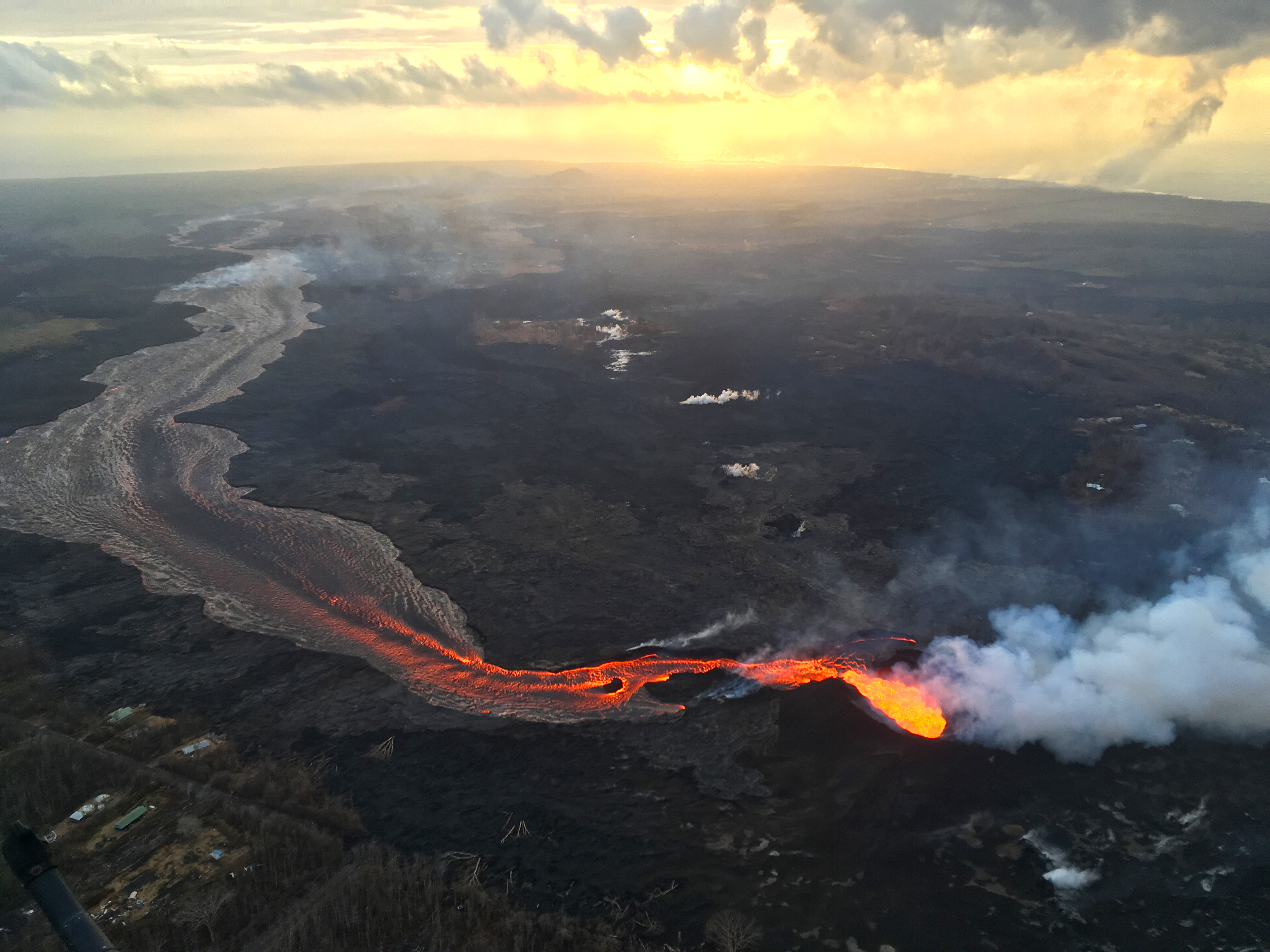
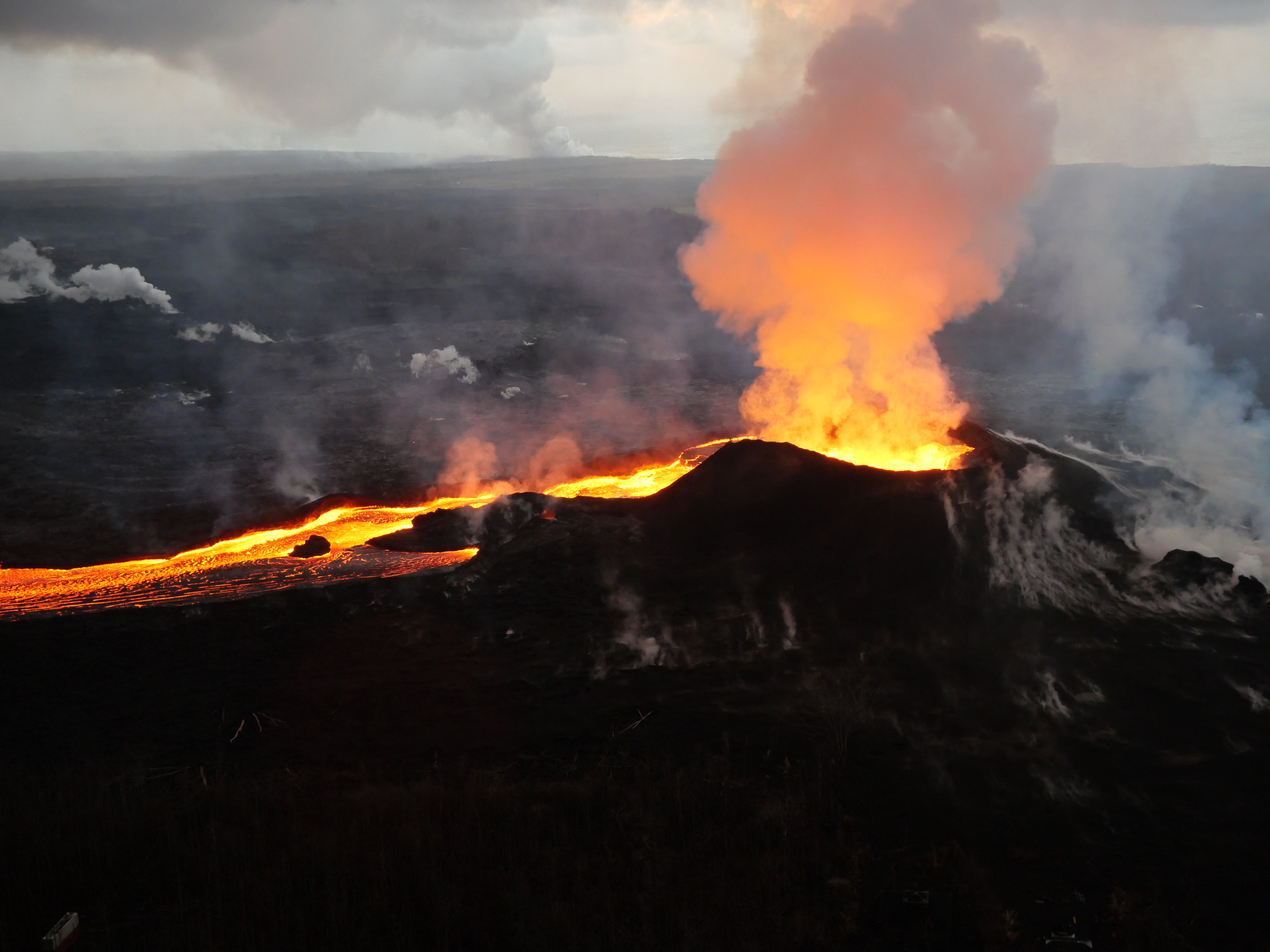
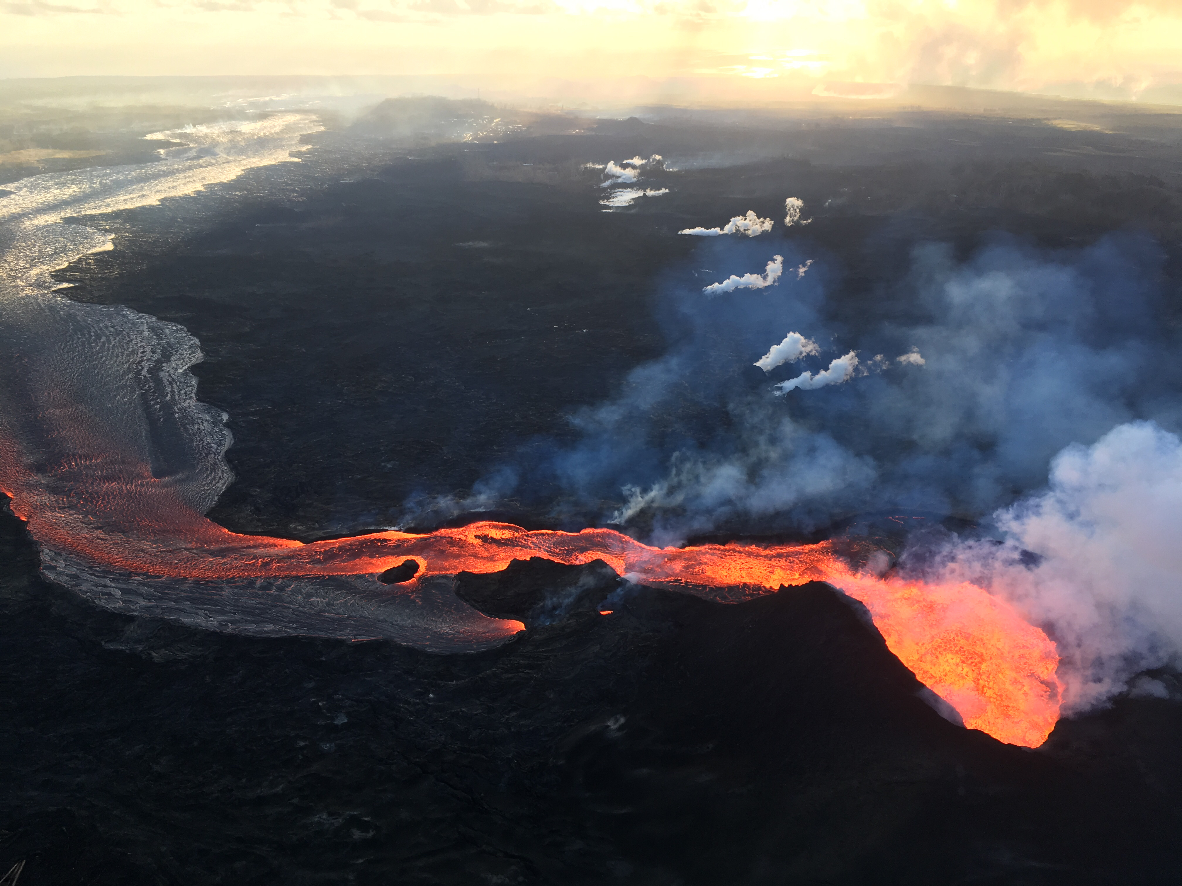
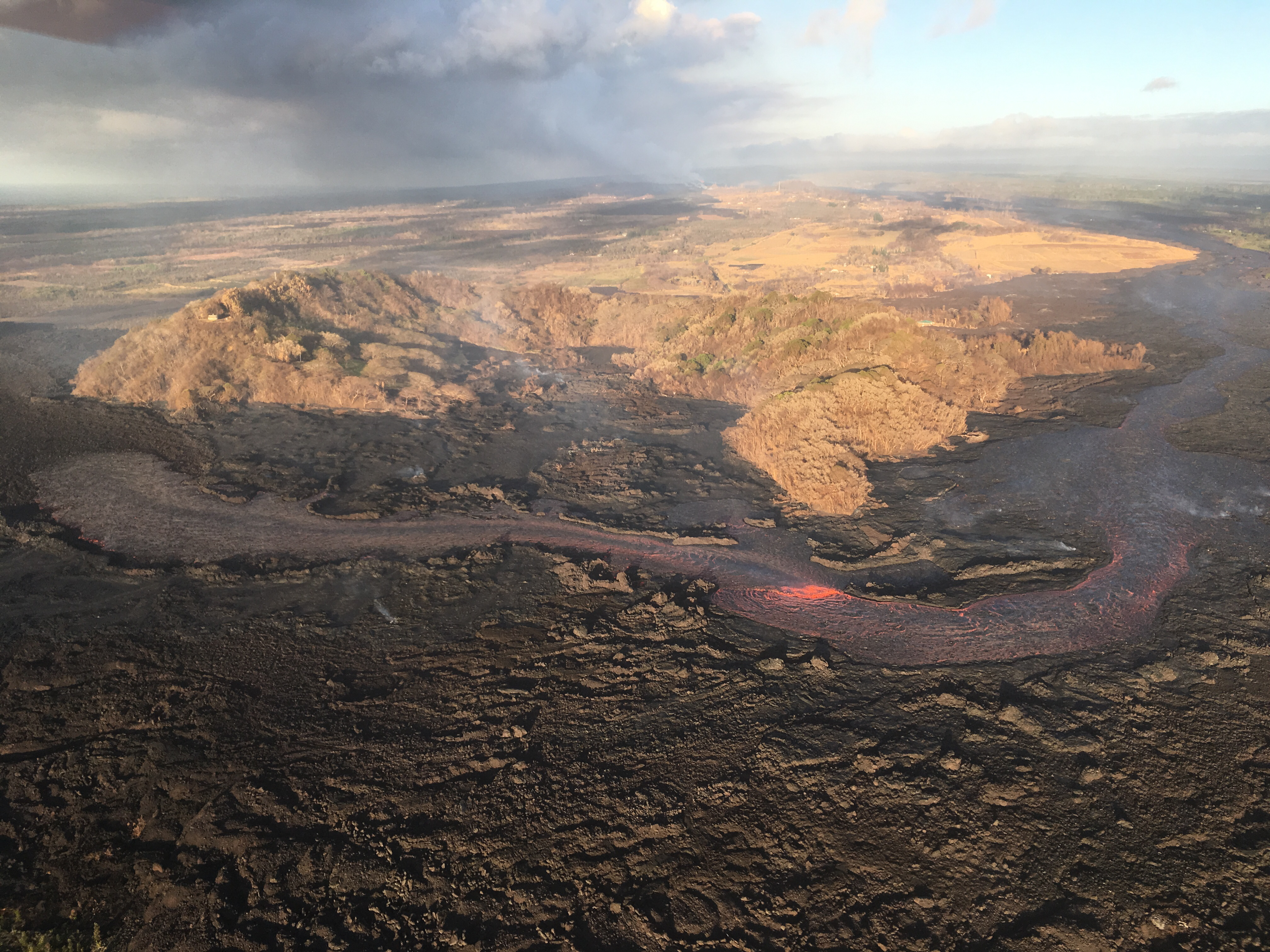
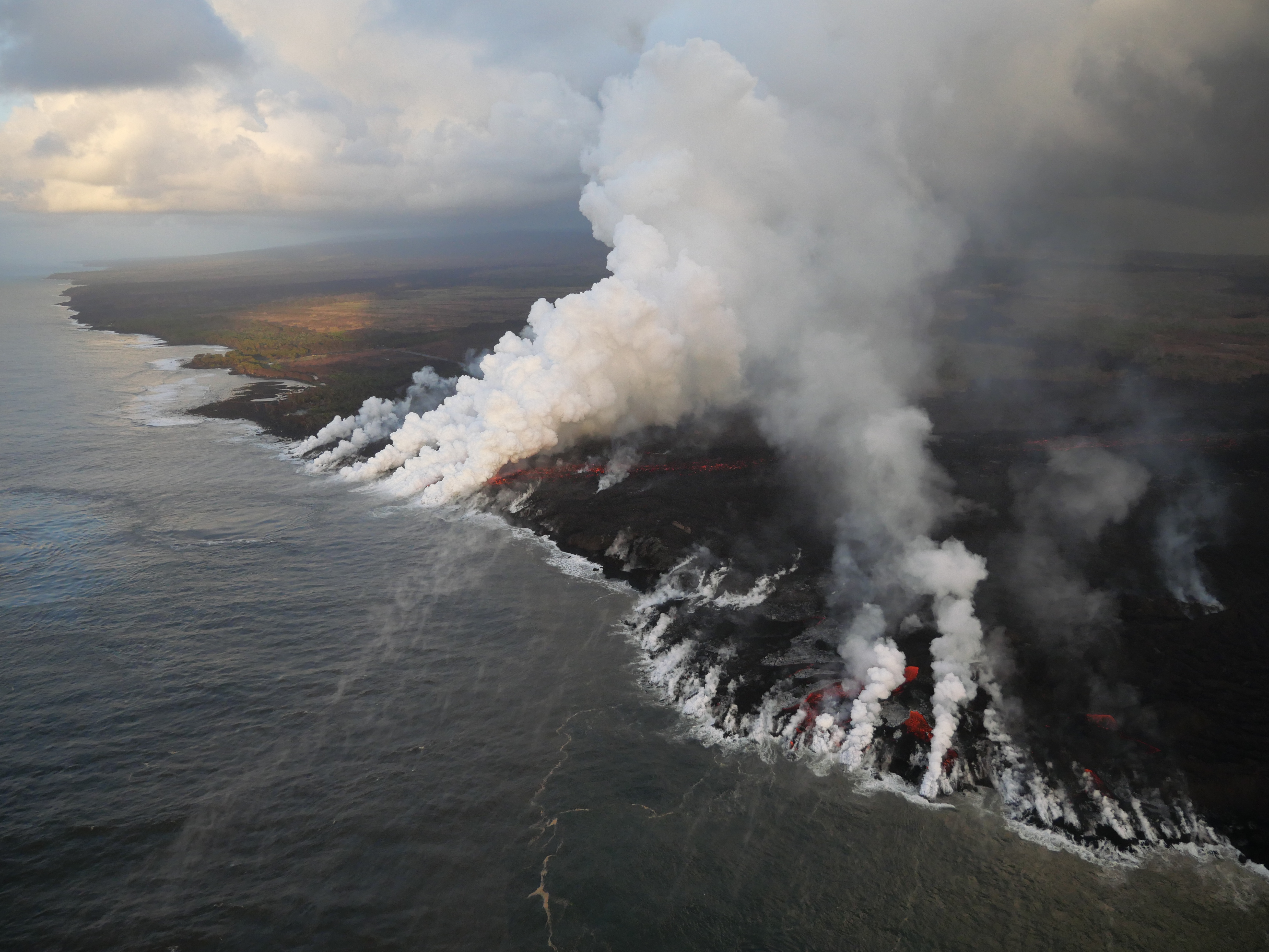
July 17, 2018. USGS: “During this morning’s overflight, USGS scientists captured this image of sunrise above Kīlauea’s lower East Rift Zone. Fissure 8 continues to feed a channelized lava flow that reaches the ocean, forming a large plume at the coast (upper right).” (Full-sized)
Today’s Eruption Summary
And we’re back to routine, except that Fissure 8’s providing a minor puzzle to keep HVO busy. Yesterday it didn’t exhibit the surge behavior that’s been typical after summit collapses for the week or so. Today, nowhere near the time of a collapse event, “surging was noted at the Fissure 8 cone during the [morning] overflight but had stopped by the time ground crews arrived to verify it.” Otherwise, the channel’s lava level was low this morning. No other were fissures active.
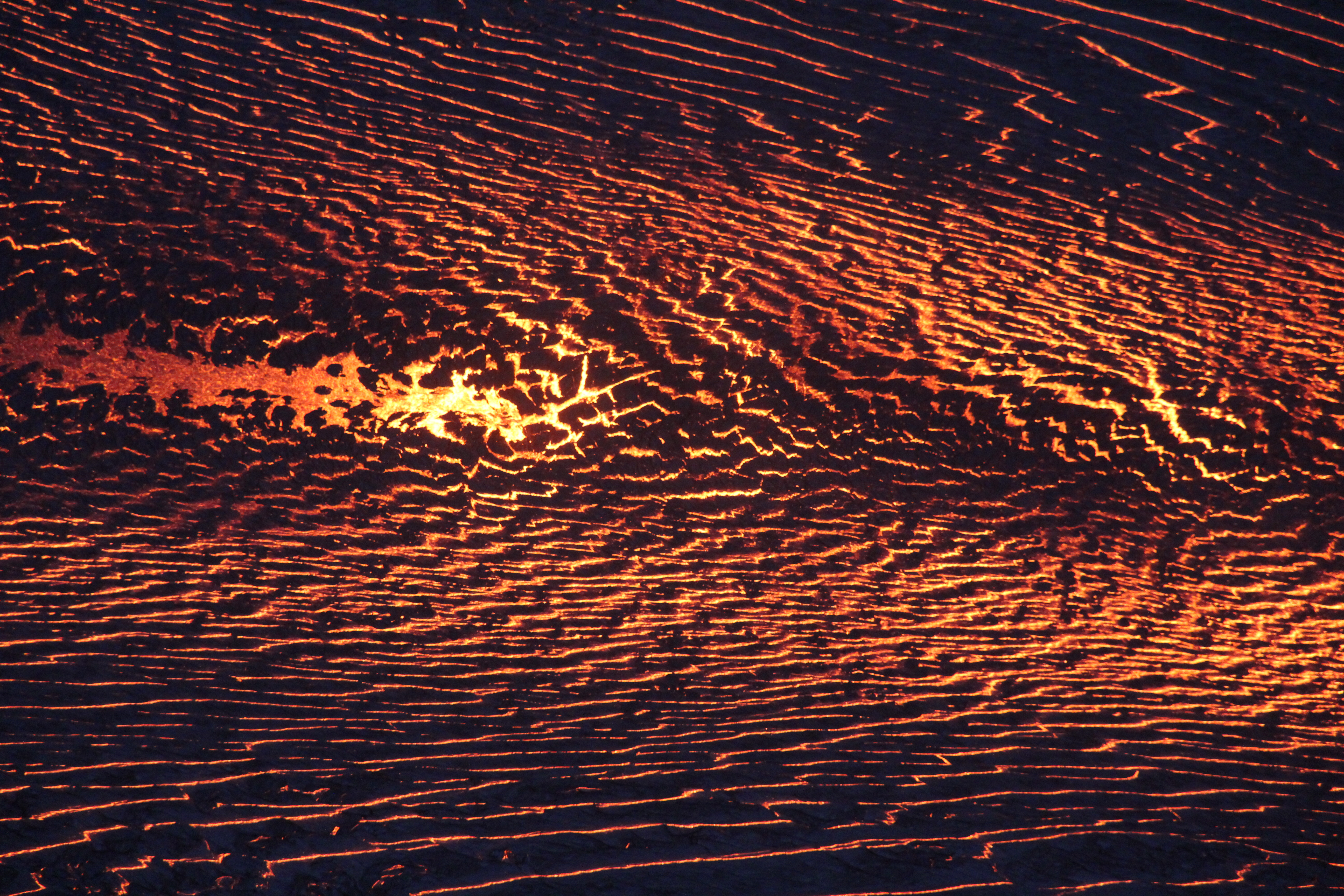
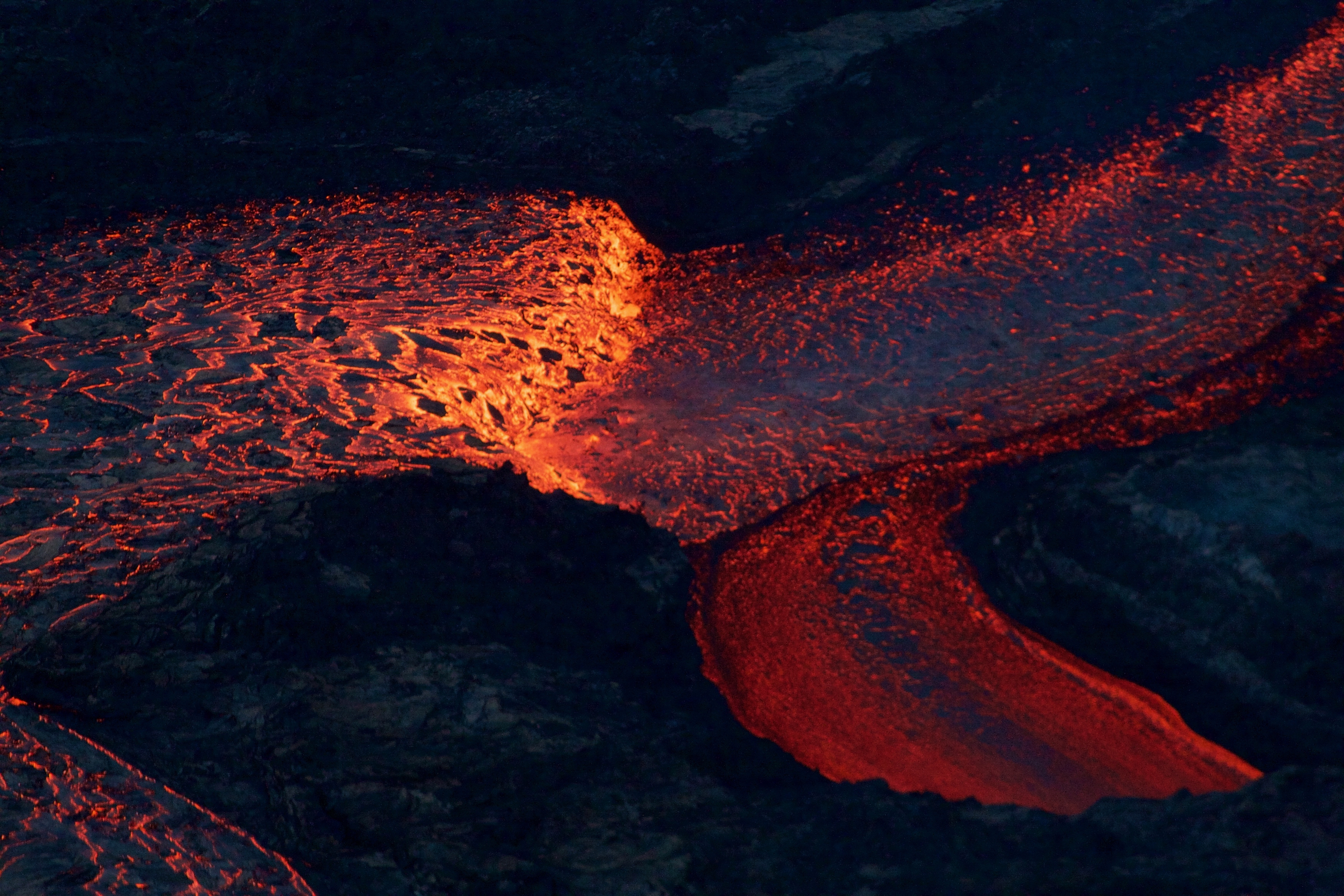
July 17, 2018. USGS: ” During their overflight, scientists used a telephoto lens to photograph the surface of the fissure 8 lava channel. Incandescent lava is visible through pieces of darker crust that forms as the flow surface cools. Note the apparent symmetry on either side of the channel center, where lava flows more quickly than it does along the channel margins—a visual representation of flow velocity across the channel width.” (Full-sized)
Both the strong southern ocean entry and weak “ooze-outs” north along the edge of the lava delta continue. Onshore, the southern margin of the flow front was reported to be half a mile from the Pohoiki boat ramp this morning. Unfortunately, that flow edge has stalled but not stopped, and a DLNR official warned Isaac Hale Park is still within its sights.
July 17, 2018. USGS: “South margin of the fissure 8 lava flow ocean entry. As of this morning, the flow was about 750 m (just under 0.5 mi) from the Pohoiki boat ramp.” (Full-sized)
We’re still awaiting the next summit collapse, which looks like it’s going to thwart HVO’s new “Northeast Caldera Rim” livestream by happening at night.
Speaking of the northeast rim, here’s the July 12 collapse event with sound from that vantage point:
Listen to the sound of rockfall in this short video taken from the NE rim of the Kīlauea caldera during the collapse/explosion event on July 12, 2018. https://t.co/bCQ1FlDr4opic.twitter.com/nvv1IkArHG
The split-second info card at the end says the floor of Halemaʻumaʻu Crater has dropped 450 m (1480 ft). Prior to the current eruption, it was 85 m (~280 feet) deep. So it’s about 1760 feet deep now. (World Trade Center One is 1776.)
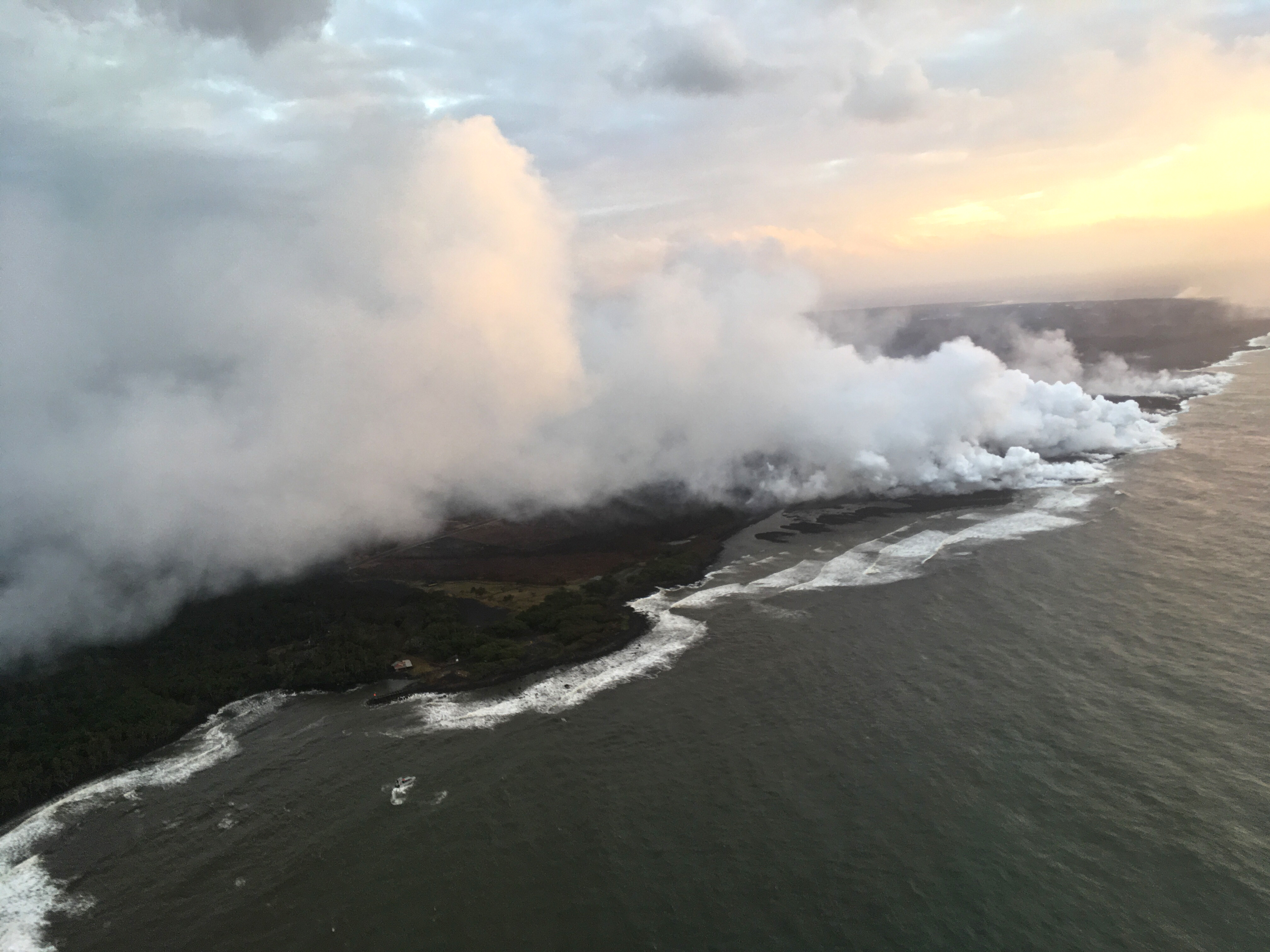
July 16, 2018. USGS: “The active ocean entry along the southernmost margin of the fissure 8 flow is a hazardous area. The interaction of lava and seawater creates “laze,” a corrosive steam plume laced with hydrochloric acid and fine volcanic glass particles that is blown downwind and can irritate the skin, eyes, and lungs. Lava flows entering the ocean can also result in explosive interactions, littoral explosions, that can hurl fragments of molten lava and rocky debris hundreds of meters (yards) inland and seaward.” (Full-sized)
Today’s Eruption Summary
The big news today was a lava tour boat getting pelted by lava chunks from an ocean entry explosion, resulting in burns, bruises, and one broken leg. Next to that, the science of this eruption seems a bit trivial. But this blog is primarily oriented towards the latter, so let’s get volcanology news out of the way first.
The Italian Space Agency released a new CosmoSkyMed radar scan of Kīlauea’s summit. Let’s hope this really is the new northern extent of Halemaʻumaʻu:
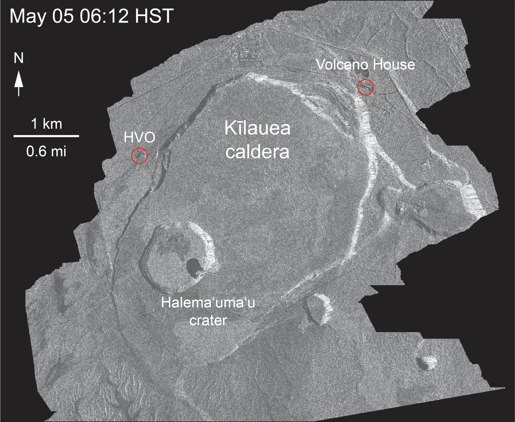
May 5-July 16, 2018. USGS: “Over time, expansion of the summit eruptive vent within Halema‘uma‘u crater and the widening of Halema‘uma‘u itself are obvious. Starting in late May, the development of several cracks outside Halema‘uma‘u is clear, and inward slumping of a large portion of the western, southwestern, and northern crater rim begins. Much of this motion appears to be coincident with the small explosions from the summit that have taken place on a near daily basis since early June. The most recent radar scene, from July 16, shows continued motion along cracks over a broader area of the caldera floor, extending east of Halema‘uma‘u. We expect this slumping to continue as long as the collapse events and overall subsidence persist.” (Full-sized)
This morning, over 24 hours after the previous summit collapse, the lava channel below Fissure 8 was full but not overflowing. Even after today’s 11:42am summit collapse, there was no observed surge— “Nothing notable in the way of overflows.” Last night’s field crews heard Fissure 22 grumbling to itself, but saw no visible signs of renewed activity.
According to Civil Defense this afternoon, the southern edge of the main lava flow has stalled 1 km from Isaac Hale Park / Pohoiki boat ramp. Just north of there, the new ocean entry at Ahalanui is vigorous and dangerous. That’s where @hotseathawaii filmed an offshore explosion four days ago. There were more explosions this morning, “with at least one being quite strong” (USGS).
July 14, 2018. USGS: ” Early morning view of fissure 8 and lava channel looking toward the east. Laze plume from the ocean entry is visible in distance (left of the fissure 8 plume). Geologists did not observe activity from any of the other fissures during this morning’s overflight.” (Full-sized)
Today’s Eruption Summary
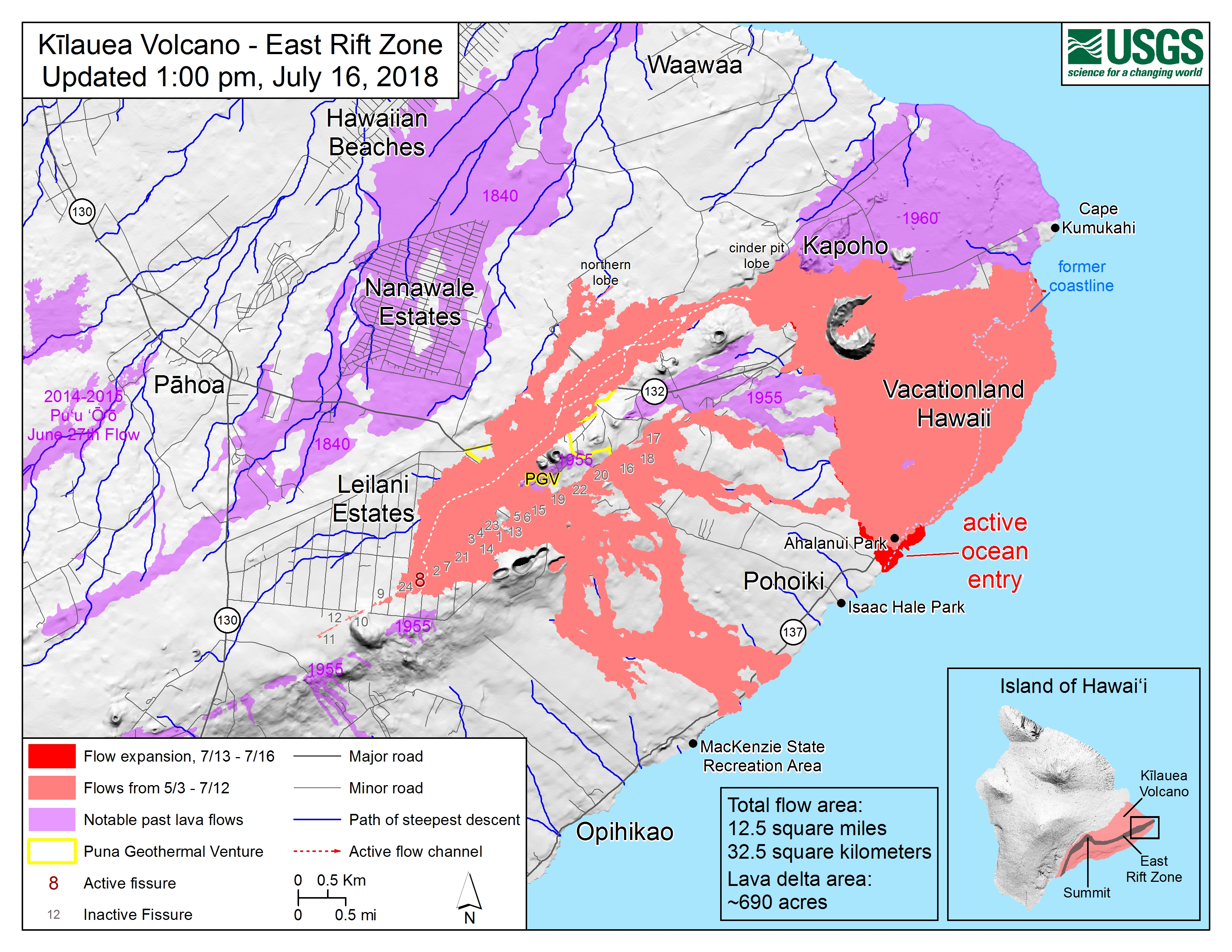
The Lower East Rift Zone eruption has settled back into a routine. Unfortunately, that routine includes the far end of Fissure 8’s lava flow crawling south along the coast, eating landmarks in its path. Isaac Hale Park/Pohoiki boat ramp (see flow map) is next in line. The morning USGS overflight reported that the flow front was about 1km away.
Friday evening, July 13, 2018, 6:00 pm – Kilauea's east rift zone overflight: Lava continues to pour into the sea at…
Fissure 8 continues to erupt into its perched channel, with its volume surging after yesterday’s 7:08pm summit collapse (Mag 5.3) and returning to lower levels by morning. That pulse caused a brief overflow on the east/southeast of the channel a short way downstream from the vent, but it stayed on the apron of previous flows.
The channelized a’a flow west of Kapoho Crater continues to be the main conduit to the ocean and to the active flow expanding southwards along the shore. North of this, lava continues to “ooze out” at various points along the June-early July flow front, whose length now totals 6km (3.7 miles).
July 14, 2018. USGS: “White laze plumes mark locations where lava enters the ocean over a broad area. An open lava channel flows into the ocean at the southern-most plume (middle) near the southern flow margin. The boat ramp at Pohoiki is about 940 m (0.58 mi) farther south of the flow margin. View is toward the west-southwest.” (Full-sized)
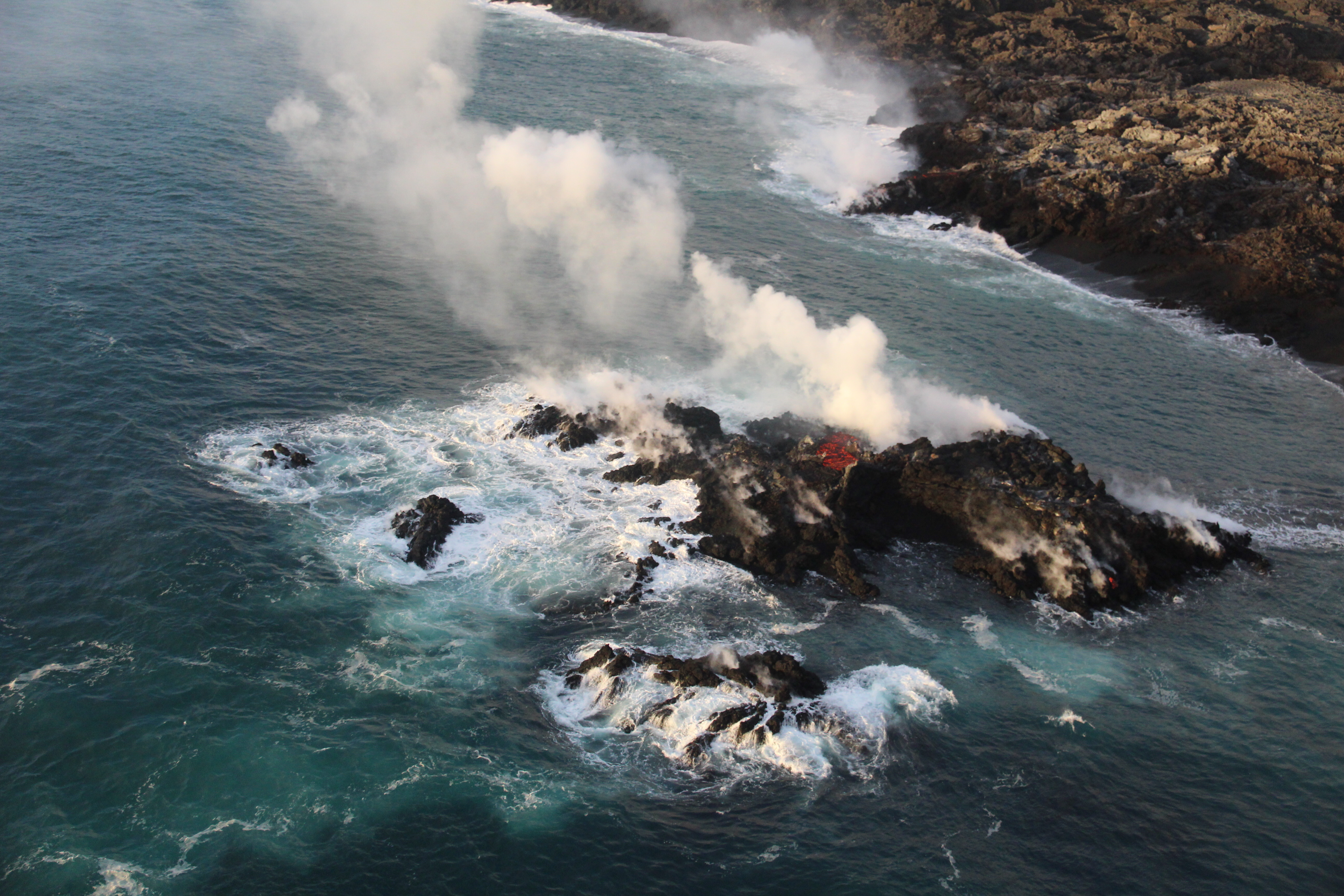
While there’s no sign of activity at any fissures besides 8, the tiny island that popped up just offshore of Kapoho yesterday is still there for now.
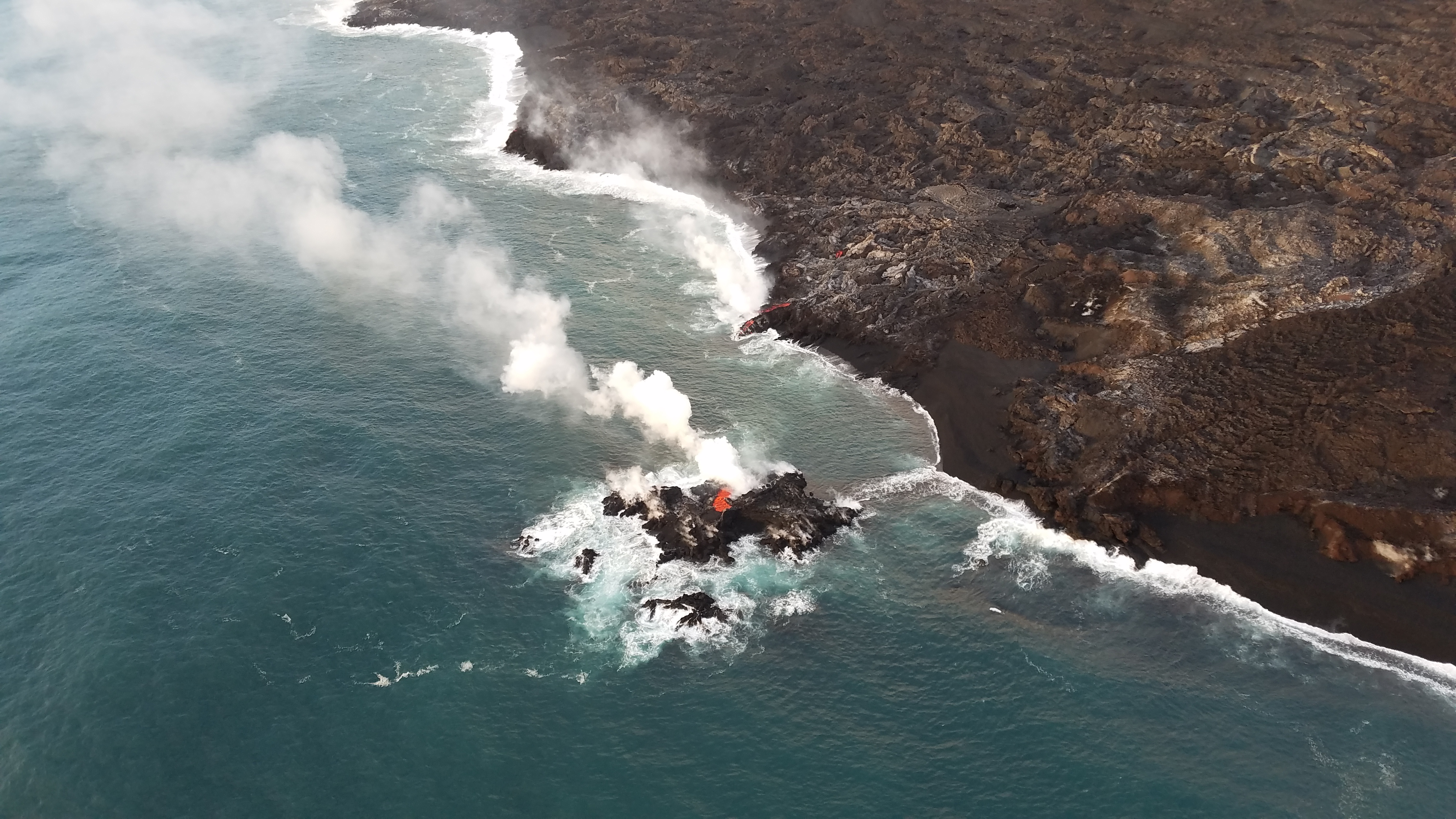
July 13, 2018. USGS: “A tiny new island of lava has formed on the northernmost part of the ocean entry. During this morning’s overflight, HVO’s field crew noticed the island was oozing lava similar to the lava oozing from the broad flow front along the coastline.” (Full-sized)
Today’s Eruption Summary
Fissure 8’s lava flow has settled into its new course, turning right just before Kapoho Cone and proceeding south-southeast to the ocean in a strong channelized a’a flow. Some lava, apparently following the earlier paths (lava tubes, maybe?) to the sea, is still squeezing out of the broad 6km (3.7) mile lava delta to the north of the new ocean entry.
A fascinating footnote: while the northern “ooze-outs” are weakening, a tiny lava island popped up just offshore of them last night, and it is itself oozing lava:
July 13, 2018. USGS: “A closer view of the new “island,” which was estimated to be just a few meters offshore, and perhaps 6-9 meters (20-30 ft) in diameter. It’s most likely part of the fissure 8 flow that’s entering the ocean—and possibly a submarine tumulus that built up underwater and emerged above sea level.” (Full-sized)
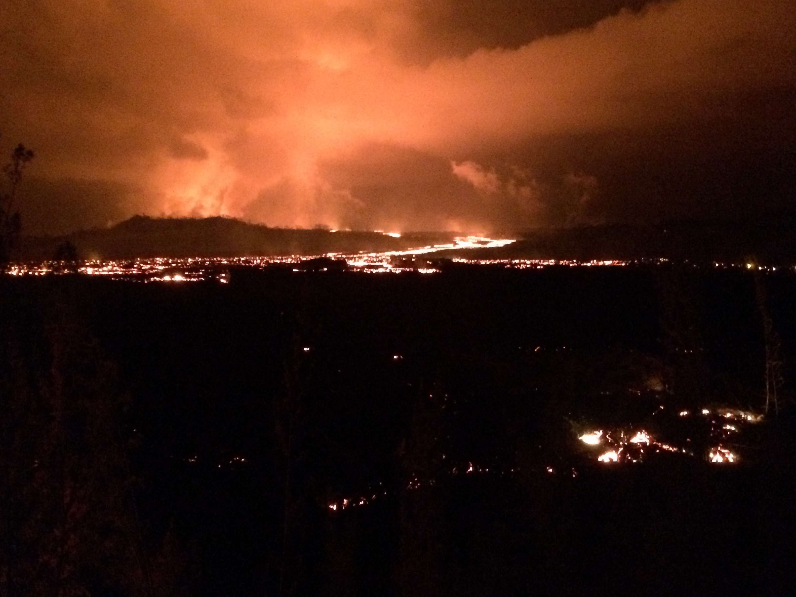
Today’s summit collapse occurred at 7:06pm HST, with the energy equivalent of a 5.3 earthquake, as usual. HVO is setting up a new livestream from Volcano House, but it’s not fully operational yet, so we made do with the ailing HVO webcam today (video clip).
July 13, 2018. USGS: “View of Halema‘uma‘u and Kīlauea caldera just before 8:00 a.m. HST today, as seen from HVO’s observation point near Volcano House. Gusty winds were blowing quite a lot of rock-fall dust, visible both within and along the rim of the crater.” (Full-sized)
It’s been fascinating watching geologists collect data, figure things out, and incorporate these discoveries into their daily Kilauea alerts. Just as the HVO team started predicting the summit’s cyclical collapse/explosions, now they’ve started predicting (or at least watching for) Fissure 8’s lava surges and possible spillovers a few hours after each summit collapse. Sure enough:
Kīlauea Message Fri, 13 Jul 2018 21:53:34 HST: Following the 19:08 HST summit collapse explosion today there was an increase in activity from fissure 8 resulting in channel overflows on the south side of the flow near the vent.
Also, we’ve got a new view of ever-expanding Halema’uma’u Crater in Kilauea’s summit caldera this morning:
July 13, 2018. USGS: “USGS scientists captured this stunning aerial photo of Halema‘uma‘u and part of the Kīlauea caldera floor during a helicopter overflight of Kīlauea’s summit this morning. In the lower third of the image, you can see the buildings that housed the USGS Hawaiian Volcano Observatory and Hawai‘i Volcanoes National Park’s Jaggar Museum, the museum parking area, and a section of the Park’s Crater Rim Drive. Although recent summit explosions have produced little ash, the drab gray landscape is a result of multiple thin layers of ash that have blanketed the summit area during the ongoing explosions.” (Full-sized)
I couldn’t find a comparable aerial photo with the observatory and Jaggar in shot, but this 2009 photo of Halema’uma’u is facing in approximately the same direction. (Look for Crater Rim Rd behind the crater on the left, and note the parking lot obscured by the lava lake’s plume in 2009— lava lake, parking lot, and part of that road collapsed into the crater in June.)
Sadly, yesterday afternoon was the end of Kua O Ka La Charter School and Ahalanui Warm Ponds. The flow that diverted west of Kapoho Crater created a channelized a’a flow all the way to the ocean. There is now a strong ocean entry at what used to be Ahalanui Beach Park. There are still multiple “ooze-outs” along the northern lava flow front spanning former Kapoho Bay— it’s now 6 km, 3.7 miles across— “despite no visible surface connection to the fissure 8 channel.”
[Below: USGS 6am overflight, July 12: Fissure 8 perched lava channel, new diverted channel around Kapoho Crater, Ahalanui ocean entry.]
Speaking of the ocean entry, Bruce Omori of @HotSeatHawaii captured a startling offshore laze/steam/lava explosion just offshore:
Huge underwater explosion from Hawaii eruption. Bruce & Mick don't quite see it and I think the explanation for that is that the GoPro shoots such a wide angle that even though it looks like it is right in front of them, it was likely below their line of sight. pic.twitter.com/otJxmh9TAg
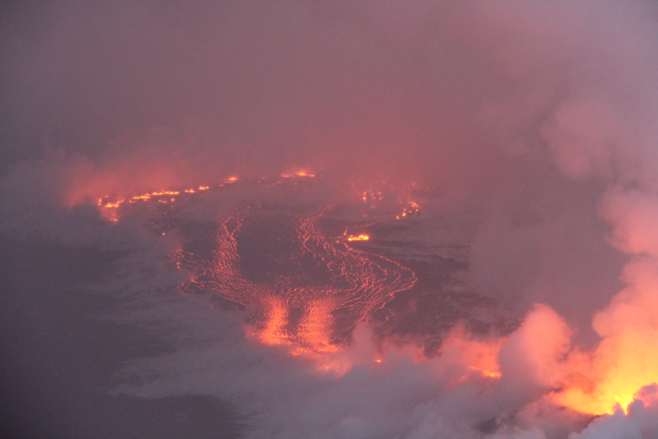
USGS: “View from Bryson’s quarry around 11:45 p.m. HST last night looking uprift past Halekamahina (an older ash cone) to fissure 8, which is creating the glow behind the cone. Bright areas indicate incandescent lava, with the brightest areas showing the trace of the lava channel. A blockage in the channel produced overflows that are seen as spotty incandescence. Lava flows in the foreground are near the base of the quarry cinder pit.” (Full-sized)
Today’s Eruption Summary
The chaos of yesterday has settled down a bit. Stormy weather has moved out, most of the overflows up-channel from Kapoho Crater have stopped, and lava is has returned to the main channel leading to the ocean, although not at the same volume as before. Yesterday’s breakout flow towards Cinder Road stalled last night. As of 4AM this morning, the only overflows still active were on the south (brown) side of the lava channel, including a new side-flow on the west side of Kapoho Crater (ocean is in the background haze):
July 10, 2018, morning overflight. USGS: “Aerial view of Kapoho Crater looking toward the south-southeast. Part of the lava channel became blocked just upstream of Kapoho Crater yesterday, diverting flows to the west and then south around the crater (center right). Lava exiting a crusted section of the channel continued flowing in the channel pathway (lower center to left).” (Full-sized)
It sounds like the southern edge of the ocean entry area has stalled too, giving Ahalanui Pond a respite (although the lava’s very, very close). But the northern side has continued to ooze as well. Today’s report from the mayor’s office said two of the the three remaining Kapoho Beach Lots homes were lost to lava in the past day or so.
There’s still multiple “ooze out” fingers along the edge of the delta in addition to the main channel. And Fissure 22 continues to sputter weakly.
July 10, 2018. USGS: “Fissure 8 and a full lava channel as seen during HVO’s early morning overflight. The visible road is Nohea Street in the Leilani Estates subdivision. Steam generated from heated rain water rose from the tephra deposits and lava flows surrounding fissure 8.” (Full-sized)
As of 10pm HST, we’re still waiting for the next collapse/explosion at the summit. (Should we be calling them explosions any more, or just collapses?)
In the meantime, the USGS has updated the caldera subsidence timelapse from Keanakāko‘i Overlook:
July 9, 2018. USGS: “Lava entering the ocean as seen through steam and rain early this morning.” (Full-sized)
Today’s Eruption Summary
Wild weather, overflows and significant channel reorganization have made the Lower East Rift Zone more interesting today than those living near Bryson’s cinder pit would like.
July 9, 2018. USGS: “This photograph taken during this morning’s overflight shows heavy, localized rain at fissure 8 in Leilani Estates.” (Full-sized)
Sunrise overflights by the USGS and @hotseathawaii spotted a torrential downpour centered directly over the upper lava flow (above). A rain gauge in Leilani Estates measured 9.22″ rainfall at 7am for the past 24 hours; another just a little farther away measured 6″ over the same span. All that updraft, convection and condensation even produced a modest… lavaspout…? captured on video (strong language warning):
The Kapoho end of the LERZ eruption was even more chaotic. Over the weekend, several non-USGS sources had reported that lava was starting to shift back to the south after passing Kapoho Crater, forming a slow-moving flow headed for Ahalanui Ponds (and sparing 3 of the 4 remaining Kapoho Beach Lots houses). This morning, HVO status updates confirmed the change: “The main lava channel has reorganized and is nearly continuous to the ocean on the south side of the flow, expanding the south margin by several hundred meters.” Also, while the ocean entry was still a very broad 2.5 mile front at sunrise, it’s started to coalesce a bit and shift towards the south:
July 9, 2018 (later in the morning; can’t be afternoon because of sun position). USGS: “Sourthern end of the active fissure 8 flow margin north of the Analannui Park [sic], known as the warm ponds. The flow margin is estimated to be about 500 m (0.3 mi) from the park.” (Full-sized)However, blockages in the braided section of the lava river caused further havoc later in the day. HVO’s afternoon status update reported that, “Early this afternoon, observers reported multiple overflows occurring along both sides of the main lava channel, in an area extending from near the ‘Y’ intersection at Pohoiki Road eastwards to an area just west of Kapoho Crater. Overflows on the upper part of the channel did not extend beyond areas previously covered in lava. Overflows further down the channel have reached beyond the flow field, including one flow lobe that is moving northeast from the main channel towards Cinder Rd.”
July 9, 2018. USGS: “The lower section of the fissure 8 lava channel appears to be almost completely crusted over, and the lava level in the channel was lower during this morning’s overflight.” (Full-sized)
[HVO afternoon status update cont’d] “Based on information from ground observers and morning and afternoon overflights, the lower part of the main lava channel has undergone significant reorganization. In particular, the channel that had been open near Four Corners is now mostly crusted over, and plumes from ocean entry are significantly reduced. It is likely this is due to a blockage that formed in the early morning in the main channel upstream of Kapoho Crater. Flow volumes coming out of Fissure 8 remain significant, and it is possible that changes in flow channels will continue to occur in the coming days.”
Meanwhile, up at the summit, it’s business as usual. This morning’s collapse event occurred at 9:20am, registering once again as 5.3:
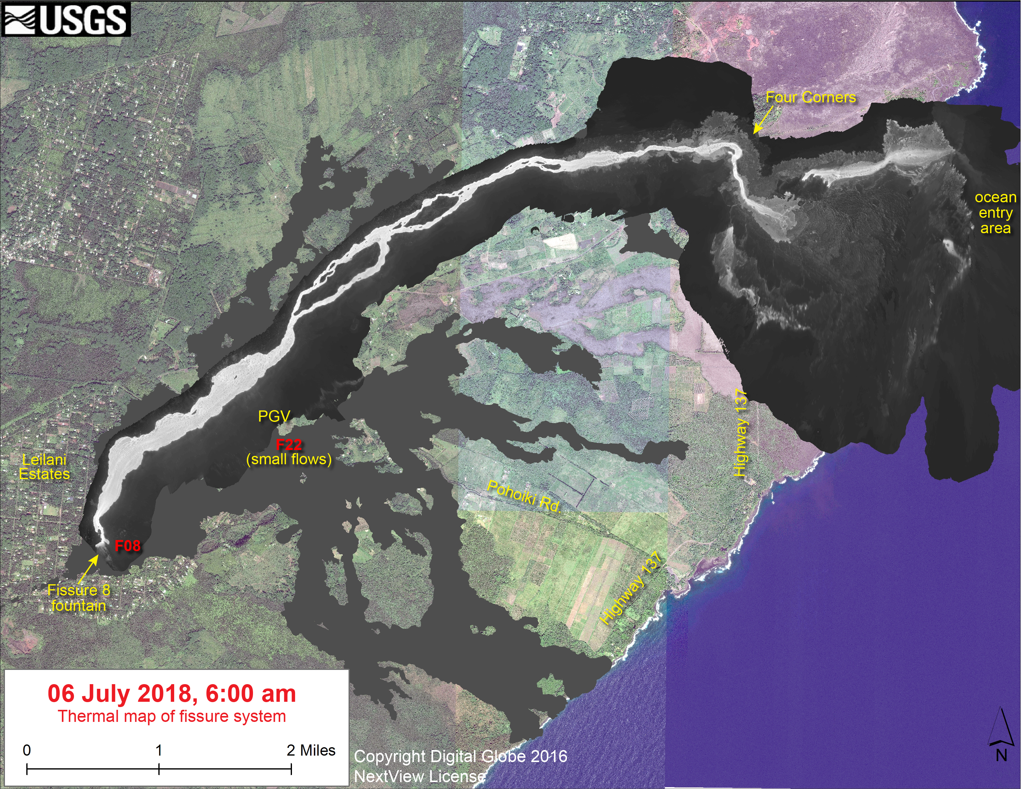
USGS posted yesterday’s thermal map first thing this morning, plus a 2pm map today showing these changes:
The LERZ continues as usual, although there are tantalizing hints that change could be on the way:
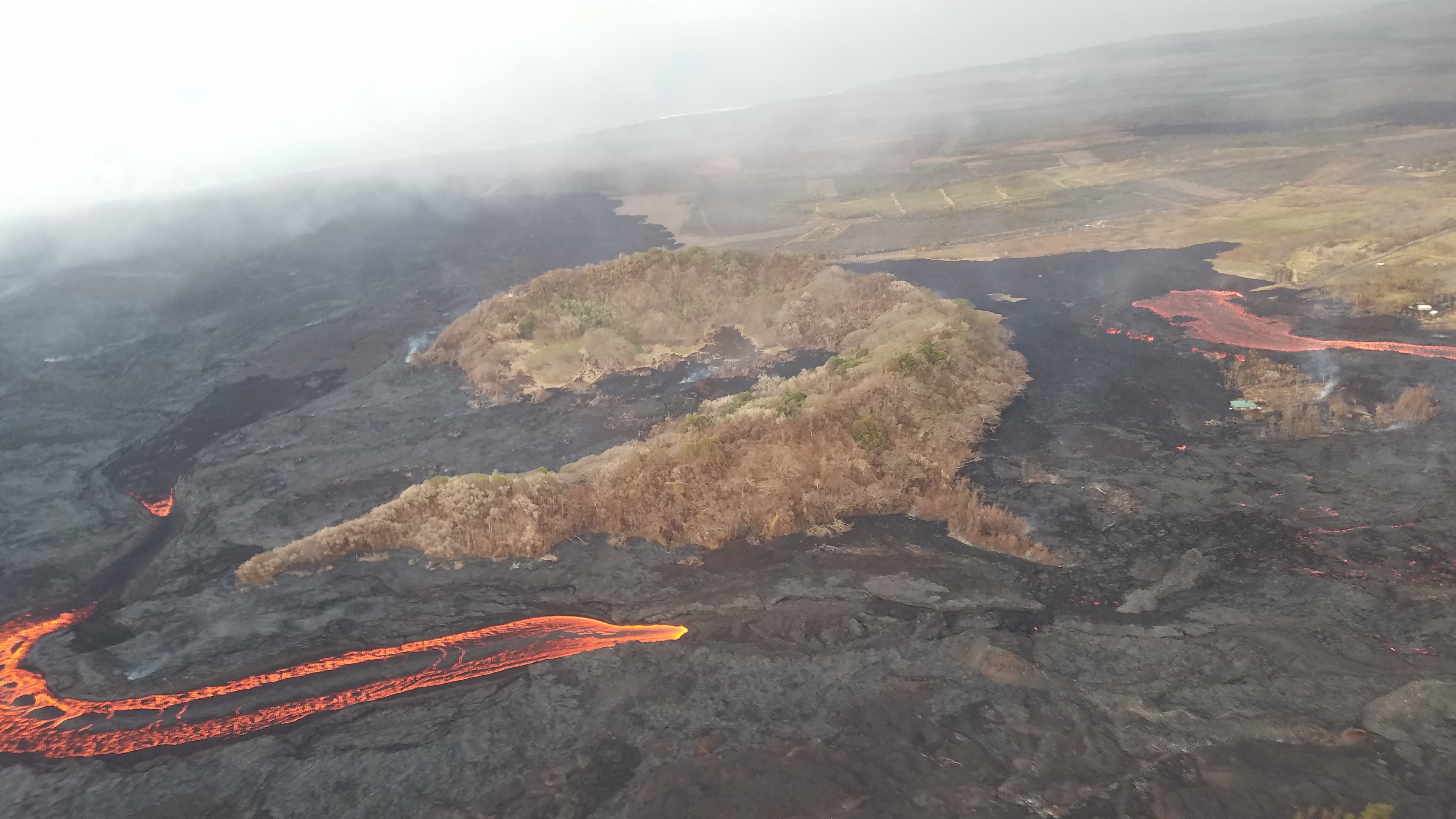
July 8, 2018. USGS: “Fissure 8 (lower right) and open lava channel leading to the northeast. Geologists noted small lava-level fluctuations in the open channel overnight, which indicates intermittent variations in lava discharge from fissure 8. An increase in lava levels was noted about 1.5 hours after the collapse-explosion event at the volcano’s summit at 02:55 a.m. HST. Evidence of a couple of recent, short-lived channel overflows were observed early this morning, but they had not reached the edge of the flow field. The small steam plumes in distance mark locations of fissures that erupted in early May at the beginning of the ongoing eruption.” (Full-sized)
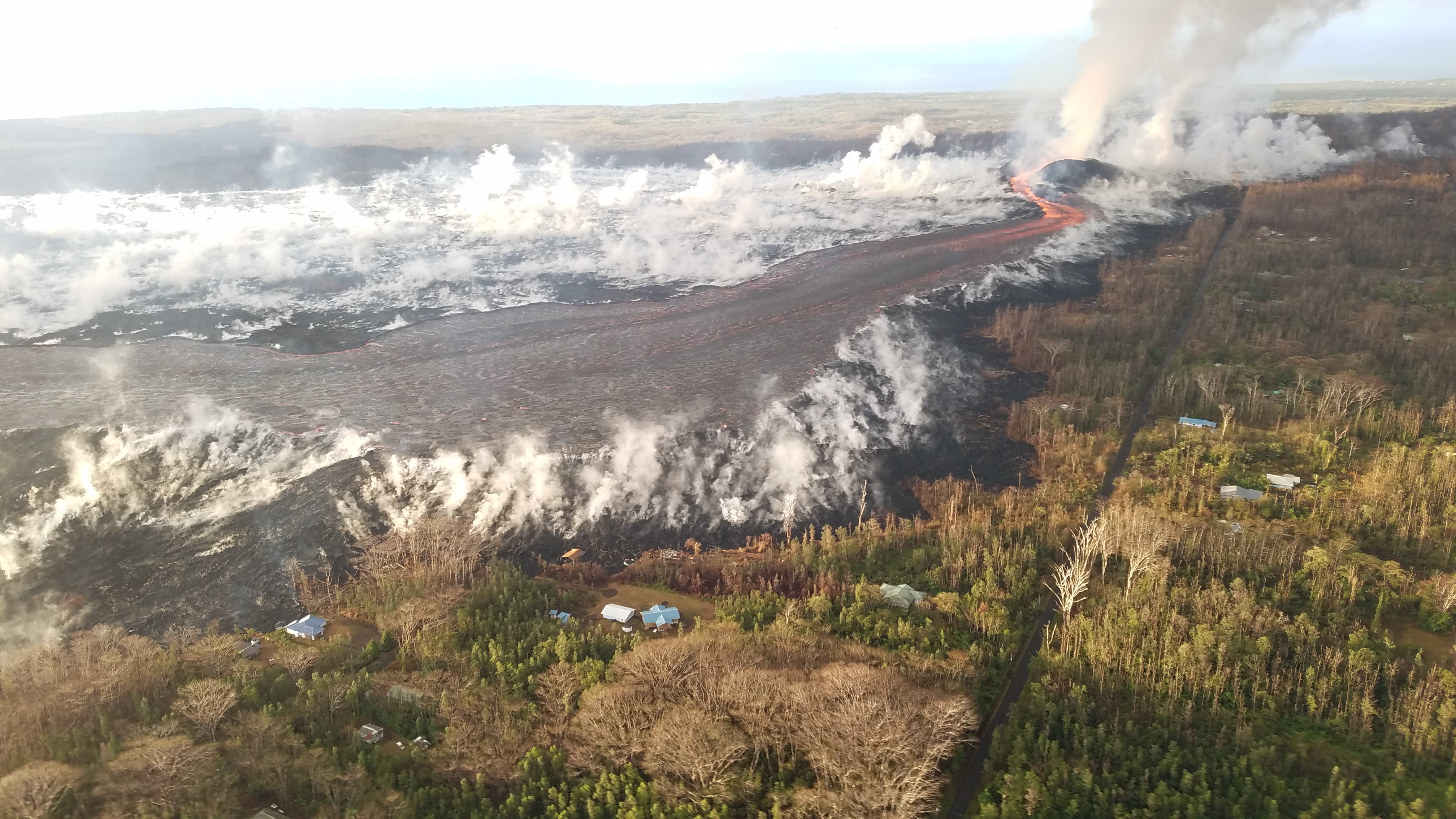
Fissure 8 gushes within its large cone, Fissure 22 continues to spatter weakly. The open lava channel from Fissure 8 now ends about 2km (1.2 mi) from the coast:
July 8, 2018. USGS: ” View of the partially filled Kapoho Crater (center) and the open lava channel where it makes a 90-degree turn around the crater. The open channel no longer directly enters the ocean. Lava flows freely through the channel only to the southern edge of Kapoho Crater (left side of image). Clearly, lava moves into and through the molten core of the thick ‘a‘ā flow across a broad area from both the sides and end of the channel.” (Full-sized)
From the end of the channel, the lava dives under the crust of the slightly older flows that buried Kapoho Bay. It emerges again along a very broad ocean entry:
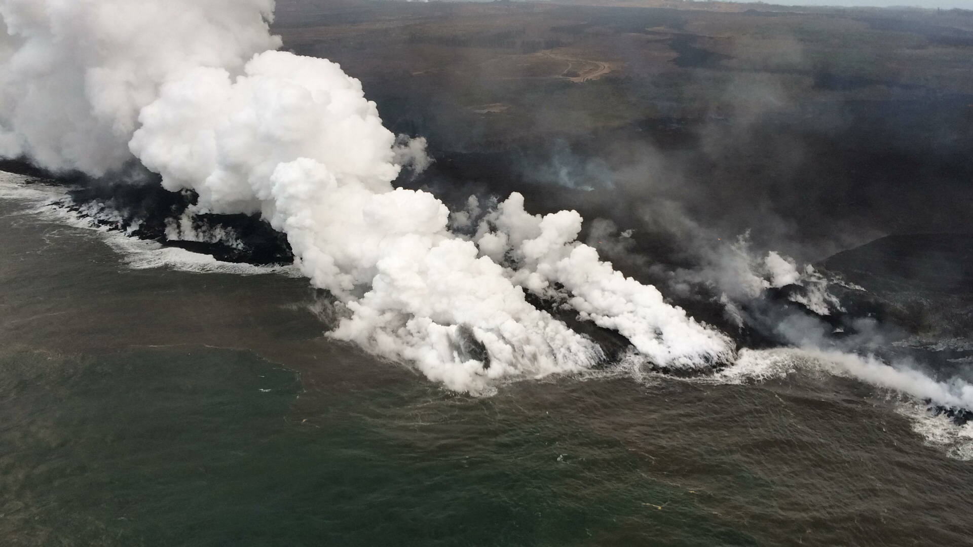
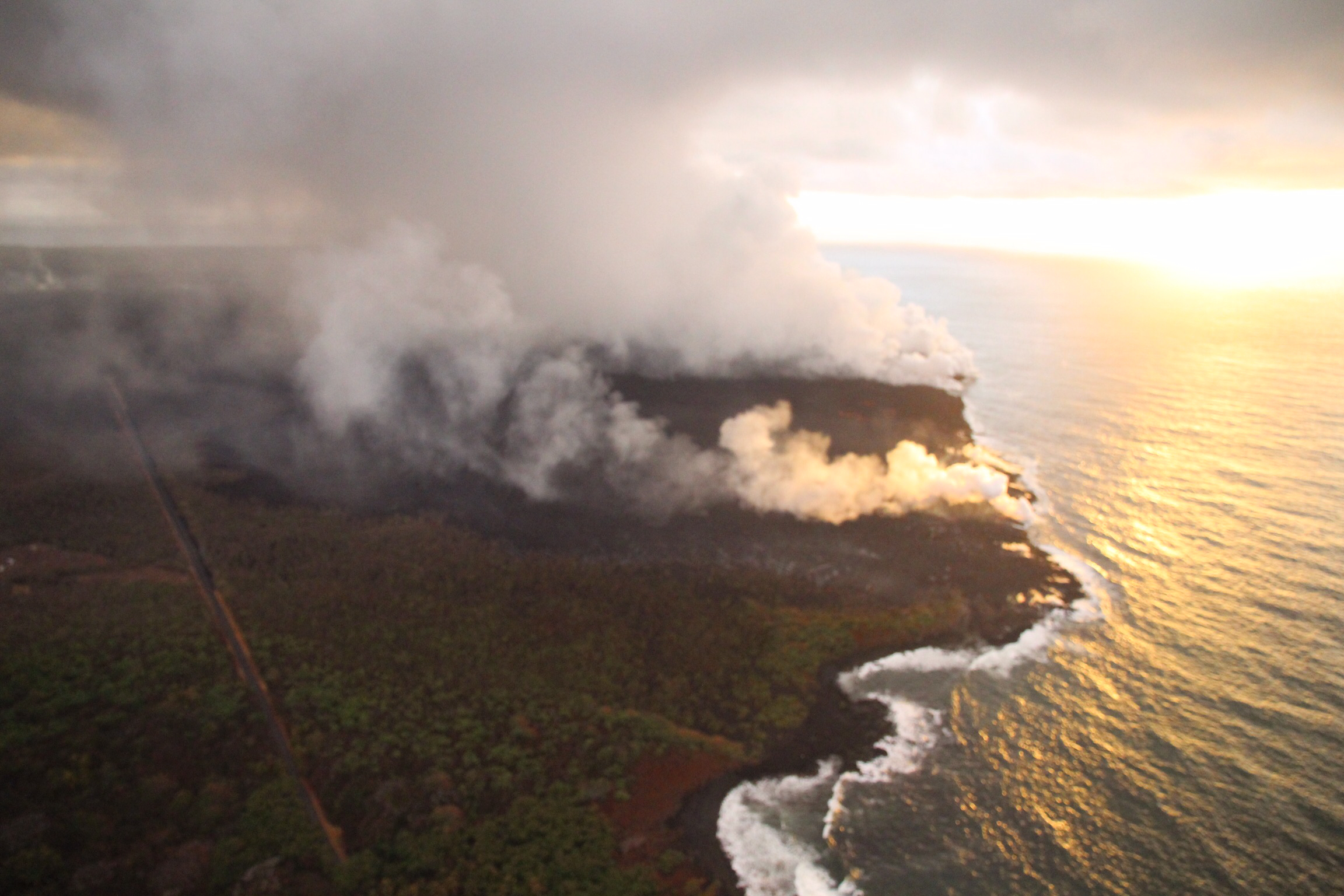
July 18,2018. USGS: “Multiple ocean entries were active this early morning, each contributing to the prominent “laze” plume above the area. Lava moves from the open channel through the molten core of the broad ‘a‘ā flow field to the ocean. Kapoho Crater is at middle right of photo.” (Full-sized)
According to USGS/HVO, the ocean entry is “primarily along the northern section,” as it has been for the past few weeks. However, to judge by today’s @hotseasthawaii overflight, there’s notable ocean entries to the south as well. Besides the lava that reaches the ocean, USGS reported lava “oozing out” to the north and southwest of the main a’a field just inland, as one can see on Friday’s thermal map. A few Kapoho Beach Lots houses are hanging on, threatened by the northern “ooze-out.” The southwestern “ooze-out” — several local photographers have reported an unconfirmed “southern lobe” lava flow— is within a few hundred yards of Ahalanai Warm Pond and Kua O Ka La Charter School:
Screencap from early morning July 8 HotseatHawaii overflight. Ahalanui Warm Pond is just at the end of that straight stretch of Hwy 137, and the school is the light-colored patch just to the right of it. (Full-sized)
Italy’s Cosmo-Skymed satellite sent down another radar image of Kilauea caldera today:
July 8, 2018. USGS: “This animated GIF shows a sequence of radar amplitude images that were acquired by the Agenzia Spaziale Italiana CosmoSkyMed satellite system. The images illustrate changes to the caldera area of Kīlauea Volcano that occurred between May 5 and July 8 at about 6:00 a.m. HST. […] The most recent radar scene, from July 8, shows continued motion along cracks over a broader area of the caldera floor, extending east of Halema’uma’u (these cracks are the scarps seen in recent photographs from the Keanakākoʻi overlook area).” (Full-sized)
July 7, 2018. A brooding Mordor-scape around Fissure 8 during the USGS morning overflight. (Full-sized)
Today’s Eruption Summary
The Lower East Rift Zone continues as usual, more or less. Fissure 8’s fountains remain tucked down in their 180′ cone, sending a river towards Kapoho. However, yesterday’s thermal map shows “the channel flow seems to stall about 2km (1.2 mi) inland of the coast.” Instead of entering the ocean from the channel, it’s oozing out here and there along a wide span of the delta, mostly on the north side. Also, lava is oozing out on both sides of the main a’a field, to the north (still menacing the narrow remnants of Kapoho Beach Lots, and it looks like it’s made a bit of a surface flow there) and southwest.
Fissure 22 is weakly spattering. And as of 9pm HST, we’re still waiting for today’s collapse event at the summit.
Apart from the weather, today was a slow news day for Kilauea watchers. So it’s a good time to catch up on this week’s Volcano Watch, HVO’s weekly column:
July 5, 2018: USGS: “Near the Kapoho Crater, in the area called Four Corners, the lava channel makes a 90-degree bend. After lava exits the bend, it makes a short drop to form a lavafall. A side channel makes a short surface diversion before rejoining the existing channel.” (Full-sized)
Today’s eruption summary
The LERZ eruption continues with minor variations. This morning’s USGS overflight crew observed that Fissure 8’s fountain and lava level in the upper channel appeared to be slightly lower. However, the lava flow rate down at Kapoho Beach Lots —where there were only a few houses left, as of this morning — seems to have picked up slightly. Meanwhile, overflows spilling out from the constricted turn around Kapoho Crater have nearly reached Beach Rd about 0.2 miles north of Four Corners. Lava continues to enter the ocean along a very broad front, mostly on the northern side of the delta.
July 5, 2018. USGS: “Lava enters the sea along the Kapoho coastline, building a delta that is now over 555 acres in size.” ( full-sized )
Fissure 22 is “sporadically spattering,” and its flow may have stalled.
At the summit, today’s collapse/explosion occurred at 1:20 PM HST, registering as a magnitude 5.2. Once again, I noticed rockfalls picking up about a minute before the big shake, although it might be coincidence (they’re happening at other times of the day as well):
The Italian Space Agency has posted a new satellite radar image of Kilauea Caldera, showing the ongoing subsidence across much of the crater floor (you may have to view full-sized version for the animation):
USGS: “This animated GIF shows a sequence of radar amplitude images that were acquired by the Agenzia Spaziale Italiana CosmoSkyMed satellite system. The images illustrate changes to the caldera area of Kīlauea Volcano that occurred between May 5 and July 4 at about 6:00 a.m. HST…Over time, expansion of the summit eruptive vent within Halema‘uma‘u crater and the widening of Halema‘uma‘u itself are obvious. Starting in late May, the development of several cracks outside Halema‘uma‘u is clear, and inward slumping of a large portion of the western, southwestern, and northern crater rim begins. Much of this motion appears to be coincident with the small explosions from the summit that have taken place on a near daily basis since early June. The most recent radar scene, from July 4, shows continued motion along cracks over a broader area of the caldera floor, extending east of Halema‘uma‘u (these cracks are the scarps seen in recent photographs from the Keanakākoʻi overlook area).” (Full-sized)
By the way, if anyone else was confused by recent Hawaii Tribune Herald articles that said SO2 levels had climbed tenfold at the summit, I checked with @USGSVolcanoes, who suggested a minor mixup. That increase is occurring down in the Lower East Rift Zone. At the summit, according to Kyle Anderson during today’s media conference call, SO2 levels have dropped to the level they were before the lava lake first appeared.


