Today’s Eruption Summary
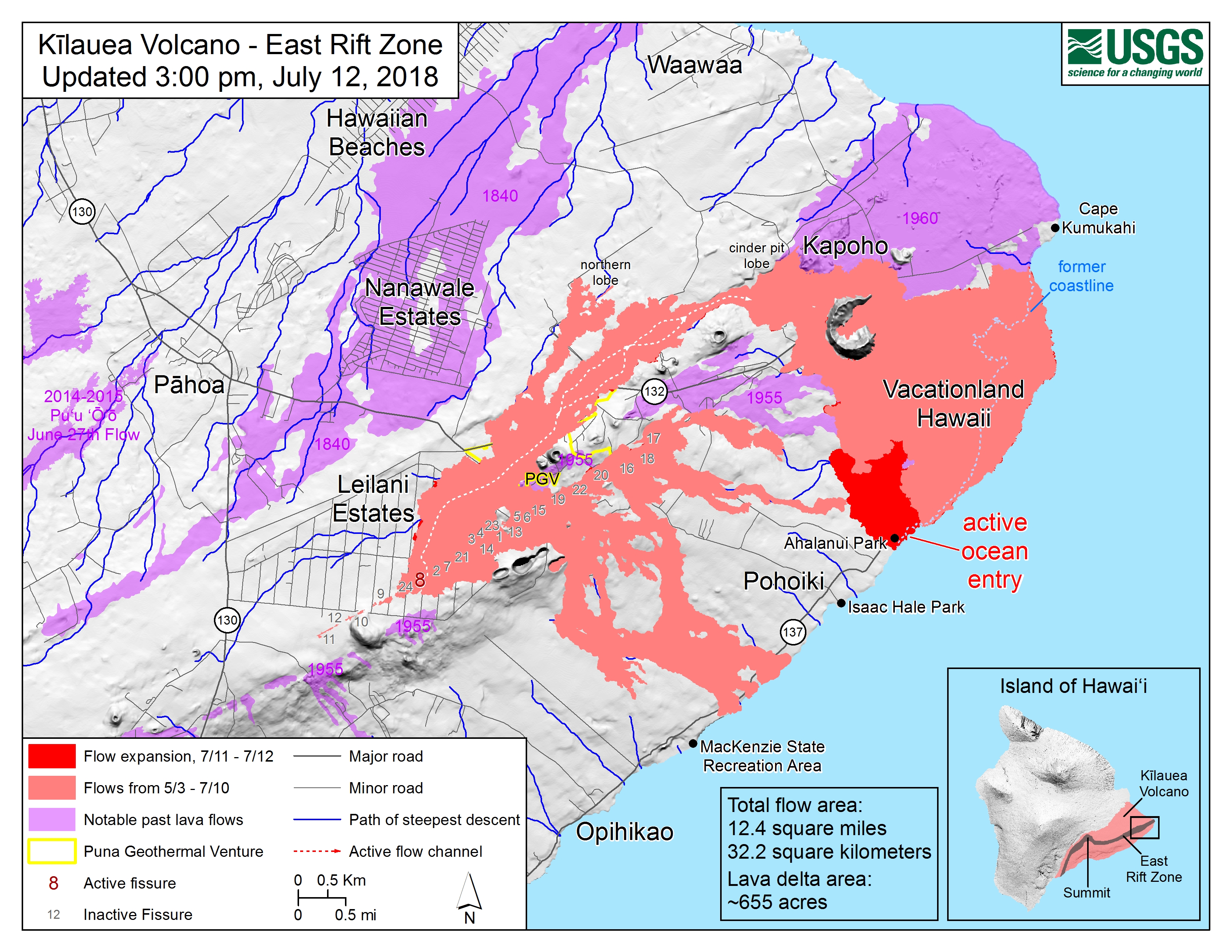
The Lower East Rift Zone eruption has settled back into a routine. Unfortunately, that routine includes the far end of Fissure 8’s lava flow crawling south along the coast, eating landmarks in its path. Isaac Hale Park/Pohoiki boat ramp (see flow map) is next in line. The morning USGS overflight reported that the flow front was about 1km away.
Friday evening, July 13, 2018, 6:00 pm – Kilauea's east rift zone overflight: Lava continues to pour into the sea at…
Posted by Extreme Exposure Fine Art Gallery on Saturday, July 14, 2018
That little island is still there this morning.
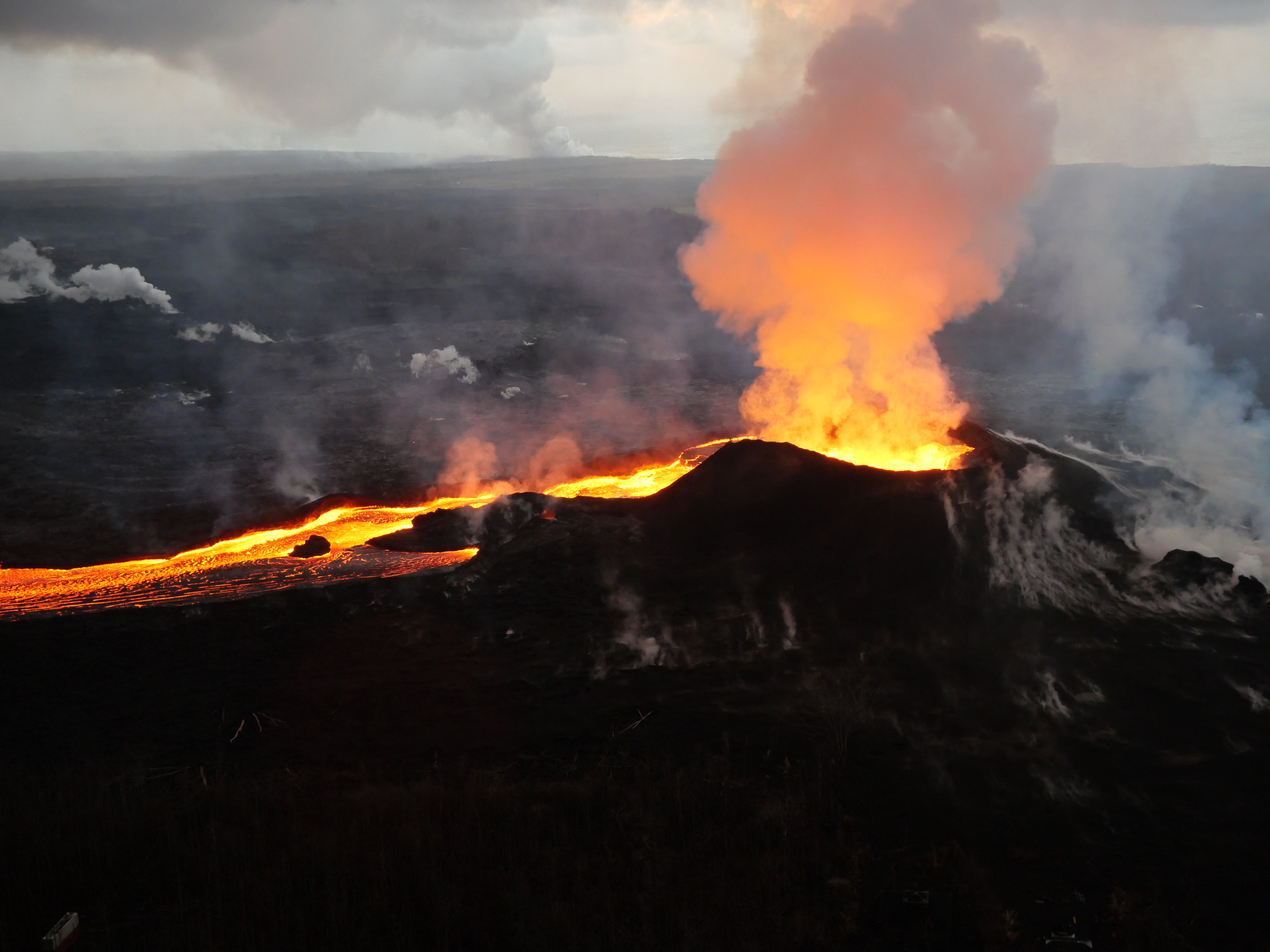
Fissure 8 continues to erupt into its perched channel, with its volume surging after yesterday’s 7:08pm summit collapse (Mag 5.3) and returning to lower levels by morning. That pulse caused a brief overflow on the east/southeast of the channel a short way downstream from the vent, but it stayed on the apron of previous flows.
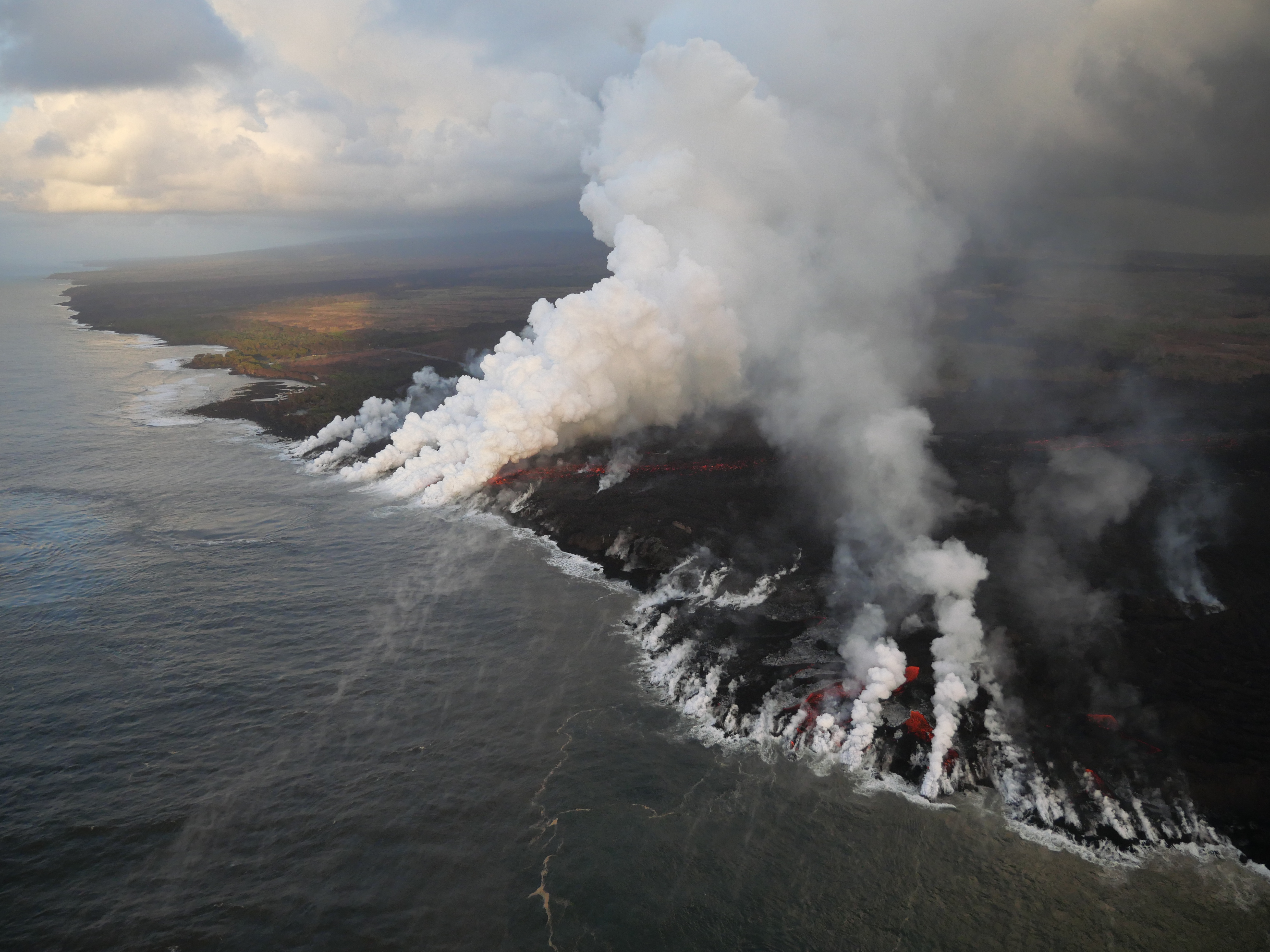
The channelized a’a flow west of Kapoho Crater continues to be the main conduit to the ocean and to the active flow expanding southwards along the shore. North of this, lava continues to “ooze out” at various points along the June-early July flow front, whose length now totals 6km (3.7 miles).

While there’s no sign of activity at any fissures besides 8, the tiny island that popped up just offshore of Kapoho yesterday is still there for now.
Odds & Ends
Heavy rainfall near #Pahoa this evening caused by convection within a plume created by the lava flowing into the ocean. We have a Flood Advisory issued. Anyone in Pahoa have flood reports to share? Please include the date/time and precise location of your report. Mahalo #hiwx
— NWSHonolulu (@NWSHonolulu) July 15, 2018
National Weather Service warned of weekend showers and possible thunderstorms, which can be turbo-boosted by the heat of the lava flow causing updrafts and instability.
Slow news day today, giving me time to catch up on this week’s Volcano Watch column (Hawaiian Volcano Observatory): “Many forms of sulfur are found on Kilauea Volcano”
And while Iain Stewart doesn’t have much to do with Kilauea, except when recording volcano documentaries, I gotta celebrate one of my favorite geologists receiving a well-earned accolade:
.@Profiainstewart has been awarded the Geological Society of America's President's Medal in recognition of his outstanding and sustained efforts in communicating and promoting the geosciences to the international public and scientific community. https://t.co/hBNWdjCJgd pic.twitter.com/2ZAaaM35zd
— Sustainable Earth (@PlymEarth) July 13, 2018
Bonus: he’s the only person I’ve ever heard say Halema’uma’u with a Scottish accent. [Timestamp 1:58 in that video.]
From Local News Media
After a flurry of articles marking the eruption’s 10-week mark, Hawaiian news outlets are taking a weekend break.
- BIVN: “Flood Advisory Issued For Puna Area“
- HTH: “Tiny island likely part of fissure 8 flow” – article also mentions Leilani Estates evacuees may now be eligible for FEMA renters’ assistance even if their homes are still standing
- HSA: “Mayor Kim wants to end Hawaii County’s purchase of land swallowed by lava“
- BIVN (Video & Article): “Hilo Orchid Show Helps With Puna Lava Relief“
- And Dispatches From Volcano has a good essay today on the naming process for Fissure 8, reflecting on how long it took for Pu’u O’o and other past eruption features to receive their official name.
Bruce Omori Friday Evening Overflight
The @HotSeatHawaii gang took a 6pm overflight yesterday. A few photos cross-posted to Bruce’s Facebook page:
Friday evening, July 13, 2018, 6:00 pm – Kilauea's east rift zone overflight: The flow that overran Ahalanui Beach Park…
Posted by Extreme Exposure Fine Art Gallery on Saturday, July 14, 2018
Friday evening, July 13, 2018, 6:00 pm – Kilauea's east rift zone overflight: A tiny island has formed near the north end of the ocean entry in Kapoho, as a subaquatic tube feeds a flow on it.
Posted by Extreme Exposure Fine Art Gallery on Saturday, July 14, 2018
Friday evening, July 13, 2018, 6:00 pm – Kilauea's east rift zone overflight: Fissure continues to rage on, feeding the massive perched channel of lava in Leilani Estates.
Posted by Extreme Exposure Fine Art Gallery on Saturday, July 14, 2018
Friday evening, July 13, 2018, 6:00 pm – Kilauea's east rift zone overflight: The braided channel glows with intensity as night falls over the eruption zone.
Posted by Extreme Exposure Fine Art Gallery on Saturday, July 14, 2018
Friday evening, July 13, 2018, 6:00 pm – Kilauea's east rift zone overflight: Lava exits fissure 8 via a narrow channel, creating a multitude of textures as it transitions into the perched channel.
Posted by Extreme Exposure Fine Art Gallery on Saturday, July 14, 2018
More photos of the tiny island, braided lava channel, Fissure 8 and flow approaching Pohoiki on his lava update blog post for this overflight.
USGS on Social Media Q&A
Q: [Can divers get close enough to film underwater activity?]
USGS: It’s been done with ROVs, but mostly with calmer eruptions in deeper water. At the ocean entry now, the water is still very hot and acidic and there are littoral explosions happening, so it would be very hazardous for a diver.
Q (Mark Landers): This afternoon the lava flowing out of #8 was pulsing wildly, it would rage and splash higher than I’ve ever seen it then go nearly flat. Ever the optimist I think any change is good. I want to believe that it is like the last drops of water flowing out of a hose; some water, some air. Could this be possible?
USGS: Yes, we were documenting swings of ~5 minutes between some waxing and waning of the fissure activity. It’s not clear what this means, although the “last drops from the hose” is a possibility. Eruptions usually end with a whimper and not a bang, so some sputtering is expected during the closing phases of eruption. But eruptions also often turn back on after these sputtering phases, so it’s too early to say what the outcome of this will be.
Q: [So the lava’s flowing west of Kapoho Crater now, bypassing the original channel?]
USGS: It appears so. There is probably still molten material in the original channel that’s making its way seaward – it’s just not visible.
Q: [Can lava “erode” the floor of its channel, or does it just build up its banks and bed?]
USGS: Yes. Lava can thermally erode downward as it flows – that’s a well known phenomenon in lava tube systems.
[Discussion about Kapoho Crater, which USGS say formed 400 years ago]
Q: [A crater that big must’ve had bigger lava fountains than we’ve seen in this eruption, right?]
USGS: Not necessarily – it’s volume and duration more than height that form a big cone. But, fountaining in the fissure eruptions in this area has been much higher in the past, up to 500 m (over 1600 ft)!
Q: [Can the cone grow even if the fountains don’t get taller?]
USGS: As long as lava can spatter up over the edges of the cone, it can add to the cone’s heigh. Right now it’s mostly roiling within the crater, so the growth phase for this cone has paused.
USGS: Indeed, they do. The land does not change hands, regardless of the volcanic activity.
USGS: Yes, the lower channel volume does appear to mean a lower eruption rate, but we don’t think it has any relation to the longer time period between summit collapses, since that is controlled by fault motion at the summit. it may mean that the rate of summit depressurization is decreasing, which would mean lower eruption rates and more time between collapse events… As for a comparison with Pu`u `O`o, the lower East Rift Zone ha erupted about 1/8 the volume of the total Pu`u `O`o eruption. Of course, Pu`u `O`o took 35 years, and the current activity has taken 2.5 months…
Q: [I read that 500 million cubic meters have left the summit. Is that true and how do you measure? And can you measure Fissure 8’s erupted volume?]
USGS: The numbers we get in both places are a little squishy. At the summit, we determine the volume change by looking at the change in topography (basically, before minus after). That number is around 500 million cubic meters. At the lower East Rift Zone, we use a combination of topographic change and lava flux in the channel to estimate something in the same range. but there is a lot of uncertainty since, for example, we don’t know the depth of the channel. It’s a critical set of numbers, but surprisingly hard to get accurate results!
Q: Has it hit the water table yet?
USGS: The lava level at the summit actually dropped below the water table back in mid-May, shortly before the small explosions began from the former summit eruptive vent on May 16.
Q: [Is the summit crater floor dropping a result of lava erupting at Fissure 8? How much could it drop before triggering explosive activity?]
USGS: Summit is collapsing b/c magma that was once stored there has moved laterally into the East Rift Zone. #Halemaumau floor has dropped about 1000 ft since subsidence began. Here’s a document discussing possible hazard scenarios at the summit. https://volcanoes.usgs.gov/vsc/file_mngr/file-184/Summit%20scenarios_7-5-18.pdf …
Q: ISS is passing over Kilauea next week; can you ask someone to take pictures?
USGS: USGS Volcanoes You’d have to ask NASA about that. They’ve gotten some good photos in the past — for example,
It is easy to see the activity on Hawaii’s #Kilauea Volcano from @Space_Station. We hope those in the vicinity of the eruption can stay out of harm’s way. pic.twitter.com/osTn3fH073
— A.J. (Drew) Feustel (@Astro_Feustel) May 14, 2018
We can still see the Earth’s fury from @Space_Station as the lava continues to flow from #Kilauea.
Expedition 56 is thinking of Hawaii as the dynamic Earth continues to evolve. pic.twitter.com/LHCBNQCXN6— A.J. (Drew) Feustel (@Astro_Feustel) June 10, 2018
Nice geeky thread about magma/lava on Facebook….
Dane Dupont: What was the date or fissure that lava from Pu’u O’o was first detected? I remember the was reports about a mix of ‘new lava’ coming from Fissure 17, but heard that was retracted. Just can’t find much about the composition of the lava.
USGS: Actually, Fissure 17 was a weird one — it was erupting a very evolved composition that had clearly been sitting in the rift zone for a long time (older than 1955, which was what we were seeing out of the other fissures). As we recall, the first sign of Pu`u `O`o composition was in mid-May (around May 12 or so) and came from the Fissure 20/22 area, but that part of the story will become clearer once we’ve formally done the full geochemistry on all collected samples.
Charles Gregory: This really makes me wonder how a body of magma can be kept at a liquid temperature for more than half a century without a direct source of heat to offset the slow shedding of heat into the surrounding rocks. Certainly, rock is a ‘good insulator’, but is it really so good that magma can stay liquified for so long? If so, does this explain post-shield-stage volcanism? That is, long after the volcano has been transported away from the hot spot, is it stray near-surface magma bodies being ‘squeezed to the surface’ (or released?) by tectonic events? How close to the surface? How close to the surface as the 1955 magma stored?
Allan Lowe: Where was that drilling done?
Oh look! rumor whack-a-mole is back!
A rather more restrained rumor than the conspiracy theories and scaremongering from earlier in the eruption, however:
Q: Will volcanoes be more active when a lot of planets are lined up on one side of the sun June 19? Also it’s Grand Solar Minimum.
USGS: Planetary alignment has no effect on volcanoes. Even you aligned all the planets, their combined effect would only equal about 2% of the Moon’s gravity, and we already question whether the Moon (which is a lot closer) can have an effect on volcanic activity.
From Other Photographers & Social Media
This is how much it’s raining, #KilaueaEruption and is this way because of the #Volcano #Fissure8 pic.twitter.com/7aGUnqcyqw
— cherie.laiken.king🌻🌻🌻 (@sunflwer1975) July 15, 2018
Image of the new ocean entry by Ahalanui Beach park. Ocean entry slow moving to the south. Currently about 2,300ft from the Pohoiki Bathrooms. Image from Ikaika Marzo. #LeilaniEstates #KilaueaVolcano #Pohoiki pic.twitter.com/YMJwivKyI8
— Dane duPont (@GeoGolfHawaii) July 14, 2018
Slow news day, so I had time to browse Instagram tags. I made myself sad hunting for photos of Pohoiki:
Finally: Distressing report from social media. Ikaika Marzo, if you haven’t been following local news enough to know about this selfless community leader, is a trustworthy source:
I hope Marzo just does what needs to be done, although he’s been pretty good about going through official channels to get permission for his animal rescue efforts from the areas cut off by lava.
Wow, what a grim note to end on. Here’s a coda.
Like hiking in a postcard. Mt. St. Helens was simply outstanding on this sunny Sunday! https://t.co/GnRCnI4YbH #MtStHelens #PNW #wildflowers #volcano #nature pic.twitter.com/XmmsrMx7qp
— myscenicdrives.com (@myscenicdrives) July 9, 2018
… life finds a way.