Today’s Eruption Summary
The LERZ continues as usual, although there are tantalizing hints that change could be on the way:
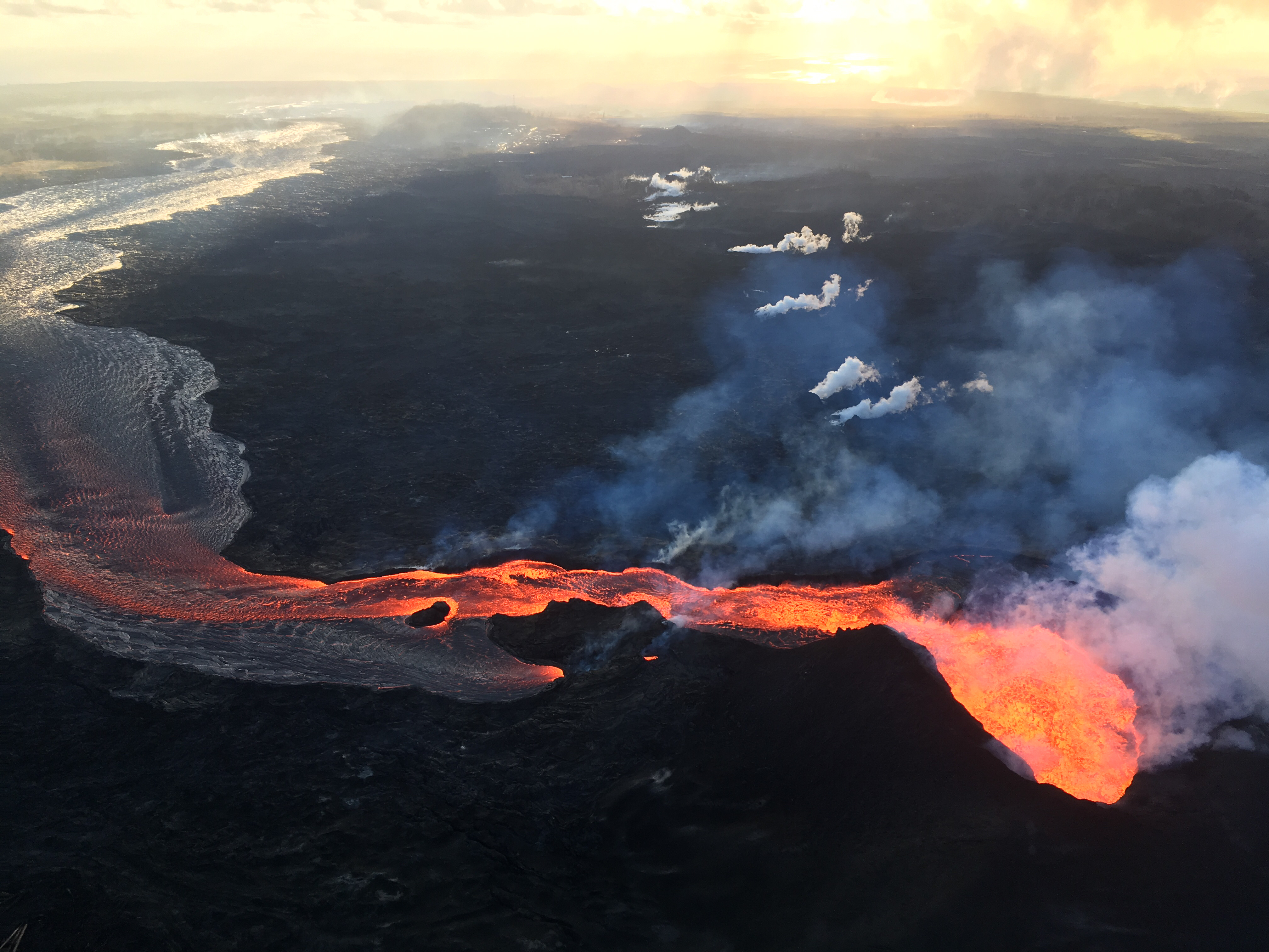
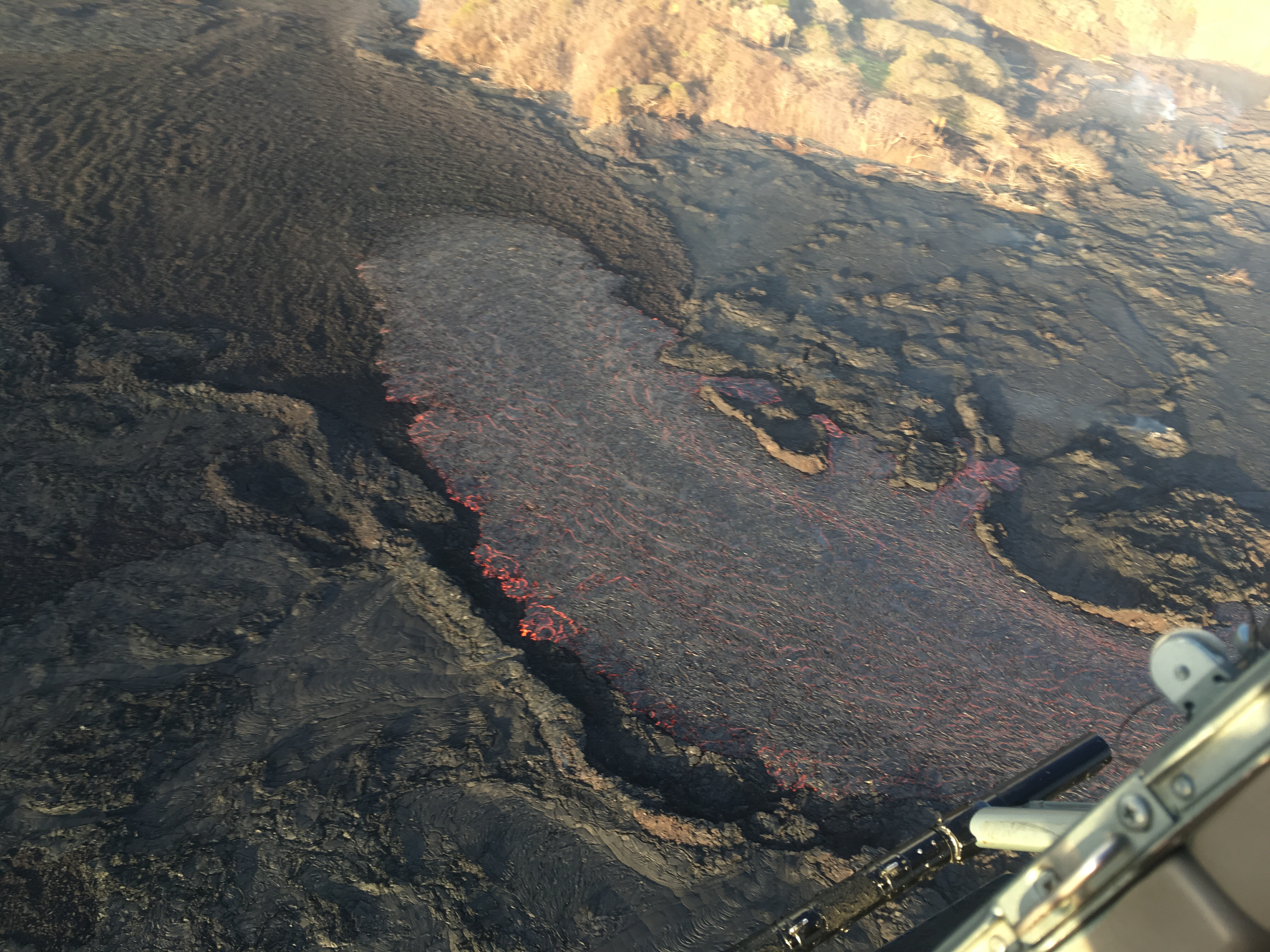
Fissure 8 gushes within its large cone, Fissure 22 continues to spatter weakly. The open lava channel from Fissure 8 now ends about 2km (1.2 mi) from the coast:
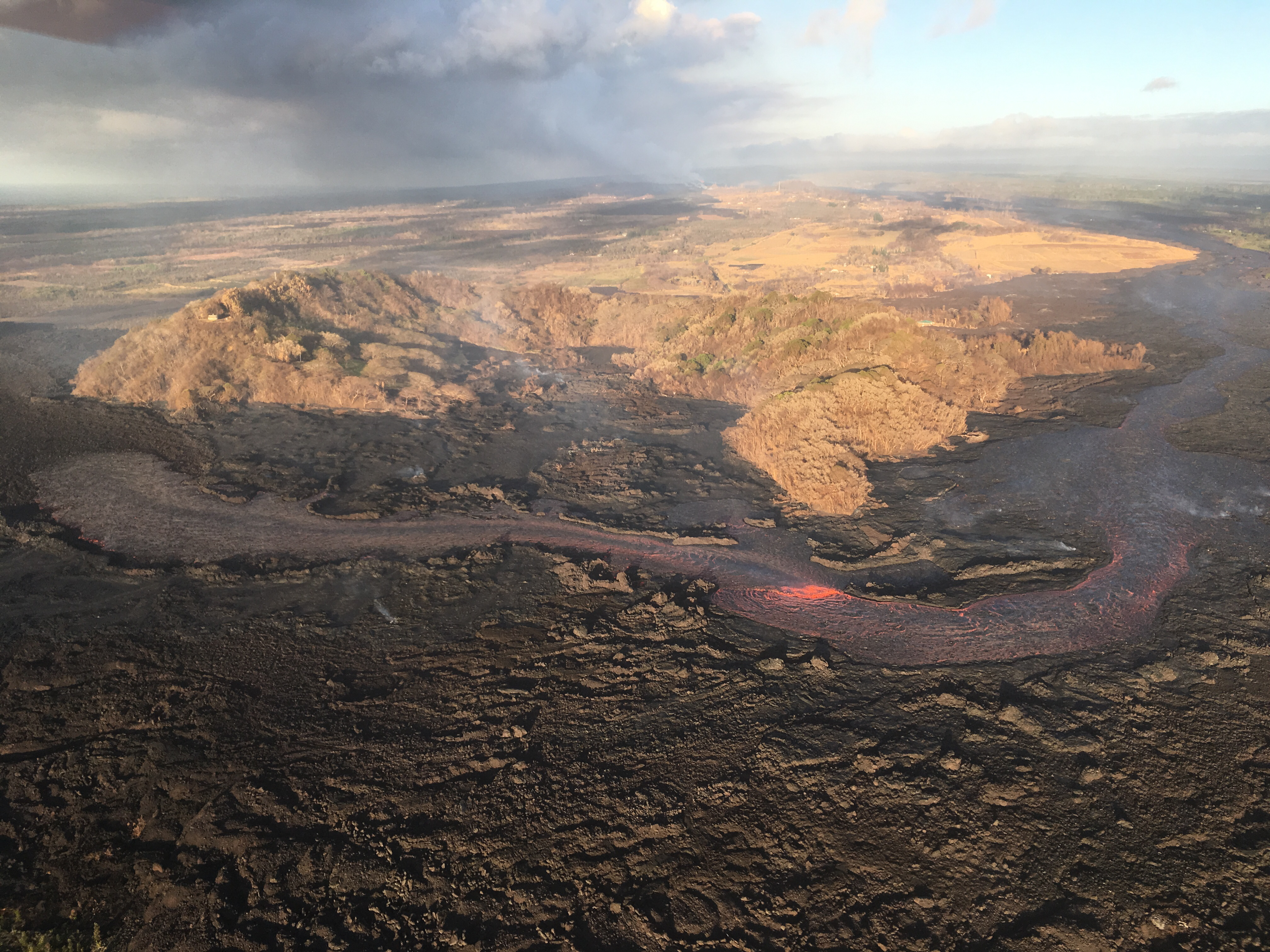
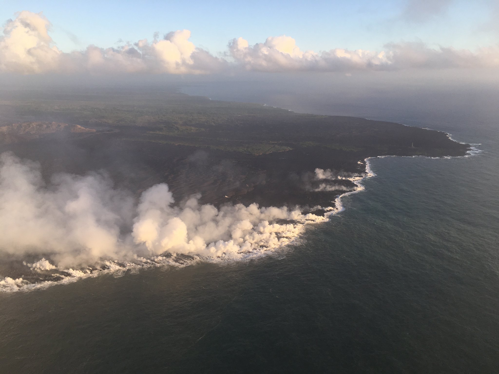
From the end of the channel, the lava dives under the crust of the slightly older flows that buried Kapoho Bay. It emerges again along a very broad ocean entry:

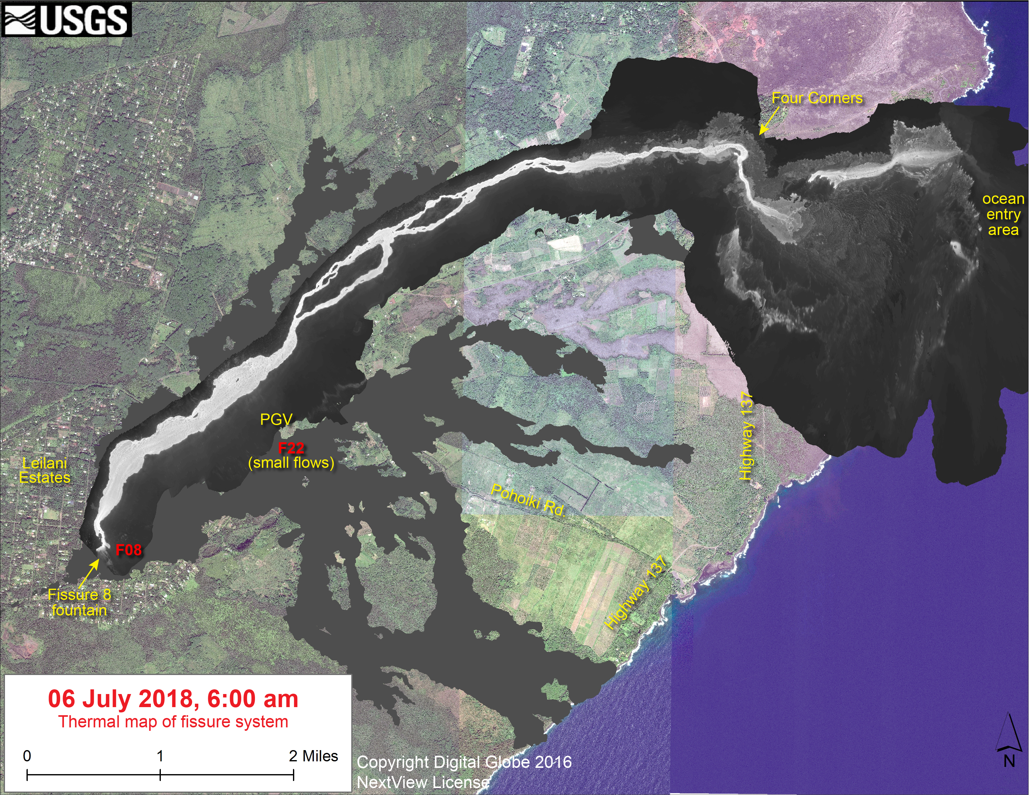
According to USGS/HVO, the ocean entry is “primarily along the northern section,” as it has been for the past few weeks. However, to judge by today’s @hotseasthawaii overflight, there’s notable ocean entries to the south as well. Besides the lava that reaches the ocean, USGS reported lava “oozing out” to the north and southwest of the main a’a field just inland, as one can see on Friday’s thermal map. A few Kapoho Beach Lots houses are hanging on, threatened by the northern “ooze-out.” The southwestern “ooze-out” — several local photographers have reported an unconfirmed “southern lobe” lava flow— is within a few hundred yards of Ahalanai Warm Pond and Kua O Ka La Charter School:
 Screencap from early morning July 8 HotseatHawaii overflight. Ahalanui Warm Pond is just at the end of that straight stretch of Hwy 137, and the school is the light-colored patch just to the right of it. (Full-sized)
The most recent summit collapse event occurred at 2:55am HST, July 8, with an energy release of M5.4.
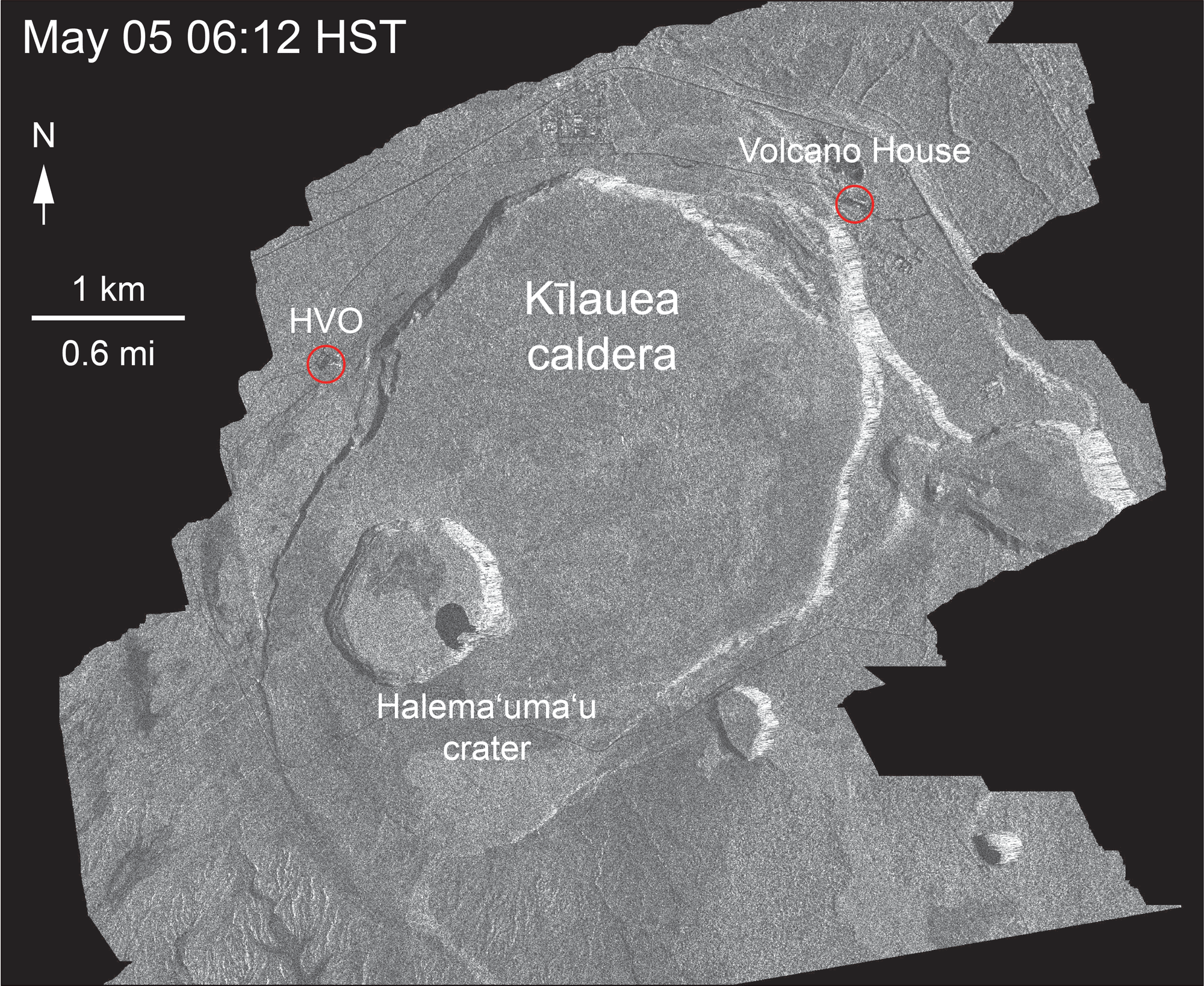
Italy’s Cosmo-Skymed satellite sent down another radar image of Kilauea caldera today:
Mick Kalber overflight video
I keep throwing various names/handles around. Let me recap, since the names have multiplied, although the people haven’t.
Mick Kalber is a videographer (company: Tropical Visions Video) who’s been documenting Kilauea eruptions on Vimeo for years, chartering flights from Paradise Helicopters (who presumably give him a discount). His friend Bruce Omori is a photographer who posts images on his “Extreme Exposure Fine Art Gallery” on Facebook. They record notes about their flights on their Hawaii Lava Update Blog. Recently, they’ve also started livestreaming their flights —I think from a phone camera— at @Hotseathawaii on Twitter. So that’s different kinds of footage from the same chaps, whose near-daily overflights supplement info from official channels.
Got it? Got it. Here’s Mick’s video clips from this morning, and his notes. This video still shows the school and Warm Pond:
From Local News Outlets
- HNN: “Community watches anxiously as lava closes in on Puna charter school“
- HTH: “HVNP staff share volcanic knowledge at astronomy center“
- HSA: “Puna Geothermal Venture faces challenges amid uncertainty“
- HSA: “Residents affected by Kilauea can register and vote at Pahoa Community Center”
- HTH: “Volunteers build additional shelters for evacuees“
- Hawaii247 has posted timelapses from all the HVO webcams for June 28-July 7. (I wish I’d taken more screengrabs from the KE webcam back in June.)
- And Dispatches from Volcano shares a dramatic pair of before-and-afters showing the new downdrop, in the space of two weeks, of Kilauea Caldera. I think the new, greater Halema’uma’u has found its outer perimeter. I hope.
-
VIDEO: The Kilauea lava wiped out one of the largest orchid growers on Hawaii island. Read tomorrow's Star-Advertiser to find out how lava has impacted nurseries on the island. pic.twitter.com/wRzL39sYub
— Star-Advertiser (@StarAdvertiser) July 9, 2018
USGS Q&A on Social Media
Q: Why did Halemaumau lava lake overflow when this started? Besides 6.9 eq.
USGS: Actually, the M6.9 event did not trigger this. Rather, the earthquake was a consequence of the intrusion of magma into the East Rift Zone. Starting in March, we saw pressure building beneath Pu`u `O`o (probably because the lava eruption was slowing, like the hose was kinked). The pressure buildup eventually propagated back to the summit, causing the lava lake to rise and overflow onto the floor of Halema`uma`u in late April. On April 30, the pressure finally caused a barrier beneath Pu`u `O`o to break, and magma began flowing downrift, eventually erupting in the Leilani Estates area. The spreading of the rift zone in response to the intrusion of magma put pressure on the large fault that underlies Kilauea’s south flank, and it moved in a large M6.9 earthquake. We’ve actually seen earthquakes like this before, after other East Rift Zone magma intrusions. Typically they are on the order of M5, but this is a much larger event, so the earthquake was also larger.
Q: MARCH! You started seeing signs in MARCH? But the roads in Leilani started cracking in May! And no one got serious until they were prepared to close the park. I realize we learn as we go but no one saw this coming?
USGS: Yes, that’s when Pu`u `O`o started to inflate. Every other time that has happened (and it has happened often — for example, 1993, 1997, 1999, 2007, and 2011 to name a few or the more significant events), there was a new eruptive vent that formed in the near vicinity of Pu`u `O`o (within about 2 km). We expected something similar to happen this time as well, given the past patterns, and issued a formal information statement along these lines.
Trying to understand why it was the main East Rift Zone conduit that broke open instead of something shallower will be a major theme of future research when we have the time to examine all of the available data. As soon as the eruption began on the lower East Rift Zone and the summit began to deflate, it became clear that summit subsidence and small explosions were a possibility, and the Park and residents of the Volcano community were alerted. The extreme lowering of the lava lake is what prompted closure of the park.
Comment on most recent satellite image of summit (the animated gif showing week-by-week collapse): Does this mean this thing is getting ready for a big one or is it dying out?
USGS: What’s happening now is a big one. But if you mean big explosion, that remains unlikely. The radar animation demonstrates that the caldera continues to collapse, which means that the magmatic system is depressurizing. Large explosions are pretty hard to generate without a source of pressurization.
Q: We’re told magma has withdrawn from Halema’uma’u before and returned, but was there also a collapse like this? This seems different: magma won’t return, but the caldera will fall down.
USGS: The caldera collapse ~500 years ago was much larger than the current one, and lava still eventually came back. This is the way Kilauea works. The stream of magma into the bottom of the volcano is more or less continuous (there are some fluctuations). After an event like this, it might take some years to refill parts of the volcano that have drained, but once that happens, eruptions can begin again.

Q: Based on past events, do we know how long, how big this collapse will be?
USGS: That’s a good question, and a tough one to answer, because we don”t have a direct record of the collapse that happened ~500 years ago (that was much larger, but would at least give us some ideas). There hasn’t been much deepening of late, because rubble infill is compensating for deepening of Halema`uma`u. Overall rates of broader subsidence (outside the collapsing area) at the summit seem down, but the collapse itself is occurring at a pretty constant rate, perhaps “catching up” to the subsurface volume loss.
Q: We know lava will return to the summit sooner or later— how about Pu’u O’o?
USGS: We suspect that Pu`u `O`o is probably done. By the time Kilauea’s magma system recharges, that vent will have been inactive for some time, and it seems hard to believe that it will be able to come back to life.
There’s been a few questions about a distant glow on the Kilauea KE cam.
USGS: We think that some of the glow you can see at night on the KE cam is from fissure 8 in the distance, not anything in the crater. [To more questions] USGS: The summit team has discussed it, and they think that it is well above the caldera rim. NPS is helping check on it, though.
We're looking into that! There has been a lot of noise in the deformation signal from the weather in the past few days, so it's possible that would filter out when the data are processed.
— USGS Volcanoes🌋 (@USGSVolcanoes) July 8, 2018
Q [two different questions, one about possibility of pyroclastic surges— someone said “USGS reported a Kilauea pyroclastic surge could affect up to a 3 mile radius around the point of the surge”, while another reiterated that Kilauea isn’t the same kind of volcano as Krakatoa, St. Helens, etc that produce major pyroclastic explosions. Second question was on the impact of 40,000 tons/day SO2 from LERZ eruption.]
USGS: Good information in all the replies! Surges have happened at Kilauea in the past — most recently in 1790 (this is the event that devastated part of Keoua’s army). They happen when an ash plume collapses under its own weight, so it would require a significant explosive eruption. At this point, we can’t discount such an event, but we do consider it very unlikely because magma continues to drain from the subsurface. Before any such event we expect to see significant changes in deformation, seismicity, gas emissions, and other indicators that would allow such an event to be forecast. As for the 40,000 t/d of SO2 from the lower East Rift Zone, that is a very impressive amount, and is a testament to the eruption rate (more lava means more SO2 — the gas emission rate is proportional to the eruption rate). The acid gases have caused harm to all of the vegetation in the immediate vicinity of the eruptive vent and contributed to vog that is being detected as far away as Guam. People with respiratory issues have long had problems with vog on the Big Island, so the problem has been a persistent one.
Q: Noticed a recent 3.1 earthquake, shallow and uprift, just south of vents 9 and 10. Does this mean anything?
USGS: A single earthquake or two is not too much cause for concern given all of the magma pumping through the system. It becomes more concerning when there is a swarm of small earthquakes that might indicate persistent pressurization (there should also be some rift zone deformation if pressure is increasing).
Q: Any correlation between subsidence at summit and variations in lava flow in LERZ?
USGS: Good question. We can see evidence for a surge, or a pressure pulse (we’re not sure which), in tilt data from the area of Pu`u `O`o. But we don’t see surges from the eruption site that are related to the collapse events. It might be that any such surges are too smeared out to be detectable at the eruption site.
USGS: Impossible to know if it is one giant tube or many. Probably it branches, much like the channel above.
Q: Any sign of a lava bench like the one that happened in 2016 [lava from Pu’u O’o eruption]?
USGSVolcanoes: We haven’t seen any collapse events to speak of — the delta seems remarkably stable — but delta collapses are very random. We don’t have a good means of forecasting those (which is part of the reason why ocean entries are so hazardous).

[Update on HVO livestream problems.]
USGS:The problem is unfortunately more complex than just a network issue at HVO. It appears to be more widespread and beyond our direct ability to fix. We’re trying to work with others to resolve the problem, but still don’t have a timeline. We use that camera too, so we’re anxious to repair the issue also.
Tim Grooms on Facebook [crediting because i’m not just giving general gist of questions; these are pretty detailed comments]: Fernandina [Galapagos volcano, 1968 collapse mentioned in this week’s Volcano Watch]. has a much shallower water table, right? That is why there were some nice pyroclastic surges during the collapse? As for Kilauea at this point and looking over all the information I can find via legitimate studies and wonderful information y’all provide, this could be a long term subsidence event like the one that caused the massive lava flows and formation of the large caldera. To get a caldera collapse like this it takes some serious work to get that rock to start moving down those faults (from what I have read). Also, do you know much more about the size and depth of the actual intrusion? I can only imaging a fraction is being erupted at the surface. In my mind, at this point this can be considered a huge eruption/ intrusion event for any volcano of this type?
USGS: Yes, in fact, there was a lake within Fernandina’s caldera at the time of the 1968 collapse. As for the intrusion, that originates 2-3 km beneath the summit and is at least 2 km below the ground out to the eruption site, where it shallows to reach the surface. Parts of the East Rift Zone have spread apart by 4 meters to accommodate the intrusion.
You’re right — this is a huge eruption/intrusion for any basaltic volcano.
Tim Grooms: On the inflation/deflation trend [at the summit] that has it leveling out on the rim could this also mean the faults are locking up and subsidence on the larger faults is having a tough time? Could this lead to a much larger collapse because magma is still withdrawingfrom the summit area but the outer faults are not adjusting to the change in pressure underneath? Is another large earthquake possible along the décollement zone to adjust to all of this?
USGS:We actually haven’t seen any motion along the larger caldera rim faults. If there were lots of stress building on those faults, we might expect to see a change in the pattern of earthquake activity. As for the decollement, there is always a possibility of an earthquake there (that doesn’t require any “push” from the magmatic system). Hopefully the M6.9 dissipated a lot of the stress on that fault, but future large earthquakes there can’t be discounted.
From Photographers & Social Media
I usually can’t bear to dig very far into the #kilauea tag on Twitter because of all the conspiracy theorists and spam, but today I got farther than usual and found some interesting things.
Kilauea Volcano🌋 lava flows near #Kapoho and Vacationland Hawaii #Hawaii #USA🇺🇸 07 July 2018 Naturalized SWIR/VIS #Copernicus #Sentinel-2A🛰️ Full-size: https://t.co/JSYsOEDw85 More images: https://t.co/2DcP6zVeAD #KilaueaVolcano #volcano #Kilauea pic.twitter.com/7IlPKIFGAB
— Pierre Markuse (@Pierre_Markuse) July 8, 2018
Here is the most recent true colour Sentinel 2 image of the #KilaueaEruption (07/07/2018) overlaid on an image pre-eruption (29/03/2018). The new 2.2km² erupted land area has been highlighted in red, with Kapoho bay completely filled. #Kilauea #Hawaii pic.twitter.com/qtj8nuBe9O
— Ross (@RossVolc) July 8, 2018
My first gig as a new @uhmanoa employee and I get to head to sea with a @NSF RAPID funded group from @WWU, @RiceUniversity, and @Scripps_Ocean on the RV KOK to map the plume behind Kilauea off Hawaii! They are deploying a acoustic rosette now and then we head to this! pic.twitter.com/DiWEfOxyHT
— Angelicque white (@aeawhite) July 8, 2018
With @GeologyWWU students Kevin Lally and Lena Gibbs, about to set sail for Kilauea volcano. Plan is to drop ocean-bottom seismometers offshore and learn about the seismicity of the submarine flank. @WWU pic.twitter.com/Ngzq0KptpN
— Jackie Cap-A (@geophysichick) July 8, 2018
The steel plates here over the volcanic cracks are 105-170 degrees. Drivers must go slow, drive with windows up, and may not stop anywhere around these steaming cracks in the road from #KilaueaEruption on #Hawaii 130 between #Pahoa & #Kalapana pic.twitter.com/mkna4mls1a
— the Weatherboy (@theWeatherboy) July 8, 2018
Earlier this week, subsidence from #KilaueaEruption near the summit caldera on #Hawaii 11 created a 5' wide by 20-30' deep hole there. Workers put a steel plate over it & fully reopened Hwy 11. This is between the closed @Volcanoes_NPS entrance & the road to Volcano Golf course. pic.twitter.com/6ZRUuKIhmV
— the Weatherboy (@theWeatherboy) July 8, 2018
Highway 130 on #Hawaii is open for now. Large, hot steaming cracks opened up on this road as part of the #KilaueaEruption. Workers put steel plates over the largest cracks so that people could travel from #Pahoa to #Kalapana. Notice dead vegetation near cracks. pic.twitter.com/veA2vSgN8e
— the Weatherboy (@theWeatherboy) July 8, 2018
Despite numerous repairs to this stretch of Highway 11 near @Volcanoes_NPS, we noticed dozens of new cracks along the road, w/some getting larger. We also noticed patches of slumping. W/ongoing earthquakes & daily 5.3+ seismic event, expect ongoing change here. #KilaueaEruption pic.twitter.com/zsSTDlxcah
— the Weatherboy (@theWeatherboy) July 8, 2018
Hawaii roads aren't a stranger to #KilaueaEruption destruction. This is a lonely sign on a weed covered roadway known before as Highway 130. It was severed by lava flows in 1980s & 1990s near Kalapana, which itself was nearly entirely wiped out then. pic.twitter.com/4jC0f6GAqt
— the Weatherboy (@theWeatherboy) July 8, 2018
Kīlauea fissure 8 last week pic.twitter.com/uYQ8fs2tNT
— Pieter (@Damsteegt) July 9, 2018
Today’s sunrise in Kapoho displayed a new ocean entry to the south, closer to Warm Ponds, (Ahalanui) half mile away. Let’s hope Pele spares this part of our coastline … 🙏. Please check out our eruption relief fund for local affected families here: https://t.co/Bs7A5w1o0c pic.twitter.com/JZ0Pblc2ff
— Demian Barrios (@thelavachaser) July 8, 2018
Another view…The new ocean entry is getting close to the hot ponds. Still pretty far at least 1/3 mile, but a little close for comfort ….
.
.#thelavastruggleisreal #thelavaeffect #hawaiilavaohana #leilanieruption #kapoho #pohoiki #lava #lavachaser #demianbarrios #hotponds pic.twitter.com/jDjJuF9H4W— Demian Barrios (@thelavachaser) July 8, 2018
A collection of aerials I captured from the Big Island of Hawaii a month back. Documenting the Kilauea Volcano & the Fissure 8 Lava river flowing into the Ocean creating some incredible laze. https://t.co/fu0bgBvjeS #hawaii #Kilauea #eruption #VolcanoWatch #LetHawaiiHappen pic.twitter.com/P5eG7uzBNB
— Toby Harriman (@tobyharriman) July 9, 2018
Nice little blog post:
I just published “The Glow in the Sky — Living on Kilauea” https://t.co/FGDm2Di5x6
— Misha Hogan (@writermisha) July 8, 2018