Today’s Eruption Summary
The big news today was a lava tour boat getting pelted by lava chunks from an ocean entry explosion, resulting in burns, bruises, and one broken leg. Next to that, the science of this eruption seems a bit trivial. But this blog is primarily oriented towards the latter, so let’s get volcanology news out of the way first.
The Italian Space Agency released a new CosmoSkyMed radar scan of Kīlauea’s summit. Let’s hope this really is the new northern extent of Halemaʻumaʻu:

This morning, over 24 hours after the previous summit collapse, the lava channel below Fissure 8 was full but not overflowing. Even after today’s 11:42am summit collapse, there was no observed surge— “Nothing notable in the way of overflows.” Last night’s field crews heard Fissure 22 grumbling to itself, but saw no visible signs of renewed activity.
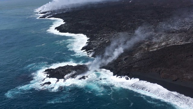
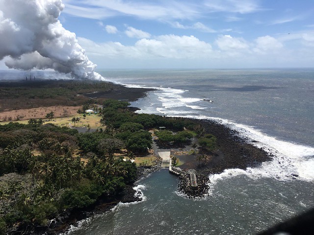
According to Civil Defense this afternoon, the southern edge of the main lava flow has stalled 1 km from Isaac Hale Park / Pohoiki boat ramp. Just north of there, the new ocean entry at Ahalanui is vigorous and dangerous. That’s where @hotseathawaii filmed an offshore explosion four days ago. There were more explosions this morning, “with at least one being quite strong” (USGS).
(The summit collapse was M 5.3 again. The livestream is still ailing, but even so it captured rockfalls, camera shake, and the earthquake’s progression from far to near in the field of view.)
July 16 Map of Active Lava Flows
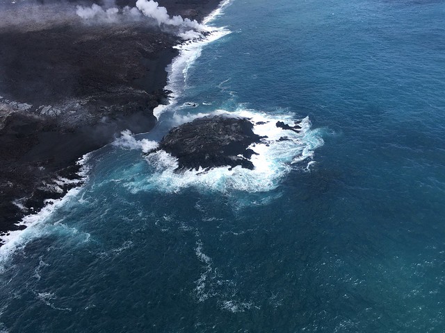
Lava delta is up to 690 acres, by the way. “Tiny no-longer-island” is next to the c in “former coastline.”

1 PM USGS Media Conference Call
The Q&A session for today’s press briefing, of course, included questions about ocean entry explosions. Starting at 3:00:
HC Fire Dept July 14 Overflight
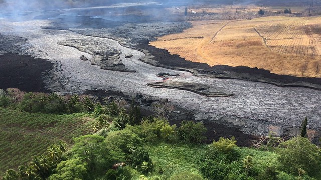
These are out of date already, but Civil Defense posted a small photo album from HCFD’s overflight two days ago. A few excerpts:
Pohoiki boat ramp / Isaac Hale Park:
And one of the lava channel shortly before it hangs a right towards the ocean:
On Saturday, F8 was brewing pyrocumulus clouds right over the upper channel that kept both the Fire Dept and USGS’ thermal mapping team away.
From Other Geologists
- Erik Klemetti of Rocky Planet blog— and everybody— are talking about “Lava Bombs from Ocean Entry Injure 22, Damage Boat in Hawaii”
- Sandatlas entry on “Volcanic Bomb” with lots of photos of these semi-molten lava projectiles after they’ve solidified, so you can get a better sense what they are.
From Local News Outlets
So yes, about that boat. Noisy explosion warning at the beginning:
Note that the explosion shown here, originally posted by Ikaiko Marzo whose boat was farther away, was a second, similar explosion that happened a minute or so after the one that hit Shane Turpin’s boat.
- HTH: “23 injured after lava explodes onto tour boat“
- KHON2 TV report: “Investigation underway after lava bomb injures 23 on tour boat” Warning: scary footage, more for sounds (screaming, sounds of lava coming down)
- KHON2 TV report: “Regulations on lava tours in the lava safety zone”
- BIVN (16-minute video and article): “DLNR Holds Press Conference on Lava Boat Incident”
- HSA: “Conditions ripe for explosions as Kilauea lava enters ocean”
- HSA: “‘Lava bomb’ through rough of tour boat injures 23 off Hawaii island“
- HCB: “Lava Flies Through Roof of Tour Boat, Injuring 23“
- HNN: “23 injured after explosion hurls ‘basketball-sized’ lava bomb onto tour boat”
- HSA: “Photos of tour boat damaged by ‘lava bomb’ on Hawaii island“
- KITV: “Coast Guard, DLNR investigate lava tourism agency after boating accident”
- HNN: “How close is too close? Coast Guard issues important reminder for boaters”
- KITV: “What is the future of lava tourism?”
- HTH: “HVO: Lava about half-mile from Isaac Hale Park“
- BIVN (Video and article): “FEMA Issues Message on Rental Assistance Denials” which is about as clear as mud, IMO
- “Dispatches from Volcano” notes that the deformation seems a little less. Maybe.
- And oh, by the way, West Hawaii Today reports, “Season’s first tropical cyclone could form ESE of Hawaii Island”
Bruce Omori – 6am Overflight today
Bruce’s Lava Updates blog post today has the usual mix of professional photos and observant commentary, including one part of the braided lava channel that’s dried up. Here’s a few of the photos cross-posted to Facebook:
Monday, July 16, 2018, 6:00 am – Kilauea's lower east rift zone overflight: Fissure 8 continues to effuse lava at a rapid rate, feeding the 8 mile long channelized flow to the sea.
Posted by Extreme Exposure Fine Art Gallery on Monday, July 16, 2018
“Overhead view of the massive ‘a‘a flow that covered Ahalanui Beach Park and Kua o Ka La Public Charter School”:
Monday, July 16, 2018, 6:00 am – Kilauea's lower east rift zone overflight: An overhead view of the massive ‘a‘a flow…
Posted by Extreme Exposure Fine Art Gallery on Monday, July 16, 2018
Pohoiki with ocean entry behind it:
Monday, July 16, 2018, 6:00 am – Kilauea's lower east rift zone overflight: Southward expansion of the flow field at…
Posted by Extreme Exposure Fine Art Gallery on Monday, July 16, 2018
Drained braided channel:
Monday, July 16, 2018, 6:00 am – Kilauea's lower east rift zone overflight: A view looking west, toward fissure 8, showing the braided channel section that has emptied of lava in the lower right.
Posted by Extreme Exposure Fine Art Gallery on Monday, July 16, 2018
Monday, July 16, 2018, 6:00 am – Kilauea's lower east rift zone overflight: A view of the dried up river bed of a section of the braided channels.
Posted by Extreme Exposure Fine Art Gallery on Monday, July 16, 2018
Monday, July 16, 2018, 6:00 am – Kilauea's lower east rift zone overflight: The tiny island that formed off of the Kapoho coast has transitioned into a peninsula, and continues to bleed a small amount of lava.
Posted by Extreme Exposure Fine Art Gallery on Monday, July 16, 2018
USGS on Social Media
By the way, it looks like USGS has their new summit livestream up, although they haven’t announced it yet. Check back when it’s daylight.

[Q: Please explain how/why that ocean entry explosion happened this morning?]
USGS: The interaction of hot, molten lava flowing into cool seawater causes pulsating “littoral explosions” that throw spatter (fragments of molten lava) and pieces of solidified glassy lava (black sand, Pele’s hair, limu o Pele) high into the air. Ocean entry littoral explosions can create hazardous conditions both on land and at sea, because the lava fragments can be thrown far inland, as well as seaward.
[Same question on Twitter: Please explain the ocean explosion today?]
USGS: If fluid lava flows directly into the ocean without crusting, it flash-boils the water and causes steam explosions. These are called ‘littoral’ explosions (where land and water meet), and can fragment lava and produce characteristic rooster-tail-shaped plumes.
[Q: Is that how black sand is formed?]
USGS: Yes, that can be a mechanism for forming black sand. Small areas of it are visible in many places along the ocean entry.
Q: Will it [the sand] last?
USGS: Some may last, but some may not. You can read about ocean entry processes here: volcanoes.usgs.gov/observatories/hvo/hawaii_ocean_entry.html…
Q: [How long does it take lava from Fissure 8 to reach the ocean?]
USGS: That’s a really good question, and we don’t know! We can’t easily follow surface features all the way to the ocean, and that would only give us a surface velocity – likely things are moving faster below the crust in places. Also, velocity is variable along the channel.

Q: [Is the lava still liquid as it reaches the sea or crusted over?]
USGS: Some of the lava river is still fluid, and some has crusted over. The southern ocean entry is probably the most fluid right now, and the northern one only fluid at certain spots along the flow front.
Q: Some Fissure 8 fluctuations don’t seem to be connected to summit collapses. Have you tested the lava’s gases to see if some of it’s coming from Big Island volcanoes other than Kīlauea?
USGS: Yes, everything continues to be coming from Kilauea’s summit area. This sort of “sputtering” is pretty common from eruptive vents. Frankly, it was the sustained flow for so long (weeks!) that was the stranger phenomenon. There is no lava coming from any of the other 23 vents in the system.
Q (Mark Landers on FB): Dear USGS volcanoes, about the recent pulsating of the lava that seems to be connected to summit eruptions.
Why might we be seeing this now but not during the last two months?
When the channel waxes and wanes does it go down below the levels we have seen lately or does it just look that way because of the surge?
USGS: It seems like the lava level actually goes down to below what we’ve become used to (if one can ever become used to such a thing). As for why we might be seeing the surges now, one possibility is that prior to the last few days, the magma conduit form the summit was full, and so could not sustain any pulses in activity (since it was already at maximum capacity). If there is a little head space in the conduit now, perhaps because there is slightly less magma overall, then there would be “room” in the conduit to see a surge/lull. That’s one thought, anyway, but we’ve got lots more data to look at to try to understand exactly what is happening.
[Another by the way: I try to avoid reposting people’s words/content unless they’ve (a) posted it on social media that allows me to embed it and leave control of their content to them or (b) it’s a public domain source like USGS. So I tend to summarize/paraphrase questions just enough to provide context for USGS responses. But if the question’s too complicated for me to summarize, I either embed the Tweet (again, that leaves control of content to the owner, since they can delete it), or, for Facebook, which doesn’t allow embedding/linking to individual comments, I cite their name.]
The eastern portion of the caldera is also subsiding. Slumping is visible here, but deformation via this radar animated gif. See deformation data here: https://t.co/4lgmc7uVX3
White is in area called "sulphur banks" – from long-lived steam rising through & altering rocks.
— USGS Volcanoes🌋 (@USGSVolcanoes) July 17, 2018
Q: Any activity from Puʻu ʻŌʻō?
USGS: Pu‘u ‘Ō‘ō has been very quiet since the significant collapse of its crater floor on April 30. Here is a view into the crater during an overflight on July 13, 2018.

Q: [In the radar animation, it looks like the caldera collapse is moving west to east. What could be causing that?]
USGS: It does look that way, and we think that might be because the main storage was centered beneath the east part of Halema`uma`u. And because things were “deeper” on the west side of the caldera (where Halema`ma`u was located), things “slid” east. Or something like that… This will be another element that gets more attention once we have more time to fully study the sequence.
Q: [Is the amount of deformation in line with the size of the summit reservoir? What would happen if the deformation blocks the conduit feeding magma down to the LERZ?]
USGS: Yes, the amount of collapse of the summit in terms of volume (basically the volume of “missing” topography) is in line with the side of the magma reservoir that existed at shallow levels before this sequence began. But the magma is draining from the bottom of the reservoir, so it’s unlikely that it will be blocked by what is happening above it.
Q: [How much more collapse is expected, based on the size of the reservoir?]
USGS: We don’t have precise knowledge of the volume of the shallow summit magma reservoir (it’s a surprisingly hard thing to constrain), but do have a good estimate that it is about 1 cubic kilometer, give or take (probably not all of that is molten). The collapse thus far exceeds 0.5 cubic kilometers, so there’s probably more collapse to be had, although we don’t know exactly how much.
Q: Has Kīlauea’s height decreased?
USGS: Yes, but not by that much (in a relative sense) — the summit might have decreased by 2 feet or so.

Q: What’s the explanation for this plot? [Data from one of the USGS deformation sensors]
USGS: These GPS data, which show the distance change across the caldera, suggest that the overall subsidence rate of the summit is slowing. Neither of these stations is within the downdropping area of the caldera, so it reflects the broader subsidence (the dropping area is still going down pretty consistently — station CALS shows this well). We’re starting to see this on several sites that are in the summit region but not located in the inner caldera, and are watching to see if it stays a consistent trend or if the broader subsidence picks up again.
Q (Jennifer Geraghty): Can someone please check the West Rim sensors?? There is very weird activity showing on it, since the M5! All other sensors are quiet, but there is a regular pattern of lines on the West Rim sensor.
Followup: This was happening from right after the M5 – 11:42 am until ~ 12:48 pm. Then the sensor went back to looking normal. It was extremely weird. Do you have an explanation of what I was seeing?
USGS: We asked one of the HVO seismologists about the signal you noticed. The suspicion is that the shaking from the collapse event sent the mass within the seismometer out of alignment, causing an instrumental artifact. The sensor gradually returned to normal and is now operating okay (but it should be releveled to make sure everything is properly aligned and that this doesn’t happen again). This overall volcanic event is so extreme that it is impacting some instruments in our networks in interesting and unforeseen ways. But you made an important primary observation — that none of the other sensors showed the same signal. This is the same principle we use when looking at signals from various monitoring data, and is one reason why we install so many sensors. That way, if one sensor goes down (for whatever reason), our ability to detect changes isn’t compromised.
Q (Tim Grooms): is the new caldera a surface expression of the shallow magma storage area that has fed Halema’uma’u for all these years? The subsidence is not showing other areas of proposed summit storage that I have read about in recent studies. Is the area that is subsiding a complete representation of shallow storage that was under the summit since the last series of collapses? I guess after any large caldera collapse it is quite the process to rebuild a shallow area of storage that becomes feeder for future summit eruptions. Could this mean the larger caldera was formed when there was time for the system to build a much larger shallow storage system, hence a much larger eruption of lava?
USGS: That’s exactly our interpretation — that the new collapse structure is basically reflecting the geometry of the shallow magma storage area that had been feeding the summit lava lake. We’re not seeing major collapse over other storage areas because those are deeper and larger. Watching the shallow storage area regrow over time will teach us a lot about how magma accumulates and is stored. As for the bigger caldera, that might have been associated with a more complete draining of the entire magma storage system, rather than just the upper part
From other photographers / Social media
We've confirmed that our meteorologist reporting from Hawaii on the ongoing #KilaueaEruption was not injured in this morning's boat accident involving a littoral explosion. Our team member uses the Ohana from Kalapna Cultural Tours for video/pics & NOT the boat involved today. pic.twitter.com/HKPSGk1WWB
— the Weatherboy (@theWeatherboy) July 16, 2018
Wonder how close those lava boats get to the #KilaueaEruption ocean entry on Hawaii? We shot this video/pictures of Lava Ocean Tour's "LavaOne" and "HotSpot", which was involved in this AM's littoral explosion event. @MilekaLincoln @USCGHawaiiPac pic.twitter.com/4qb0Y8xIgO
— the Weatherboy (@theWeatherboy) July 17, 2018


