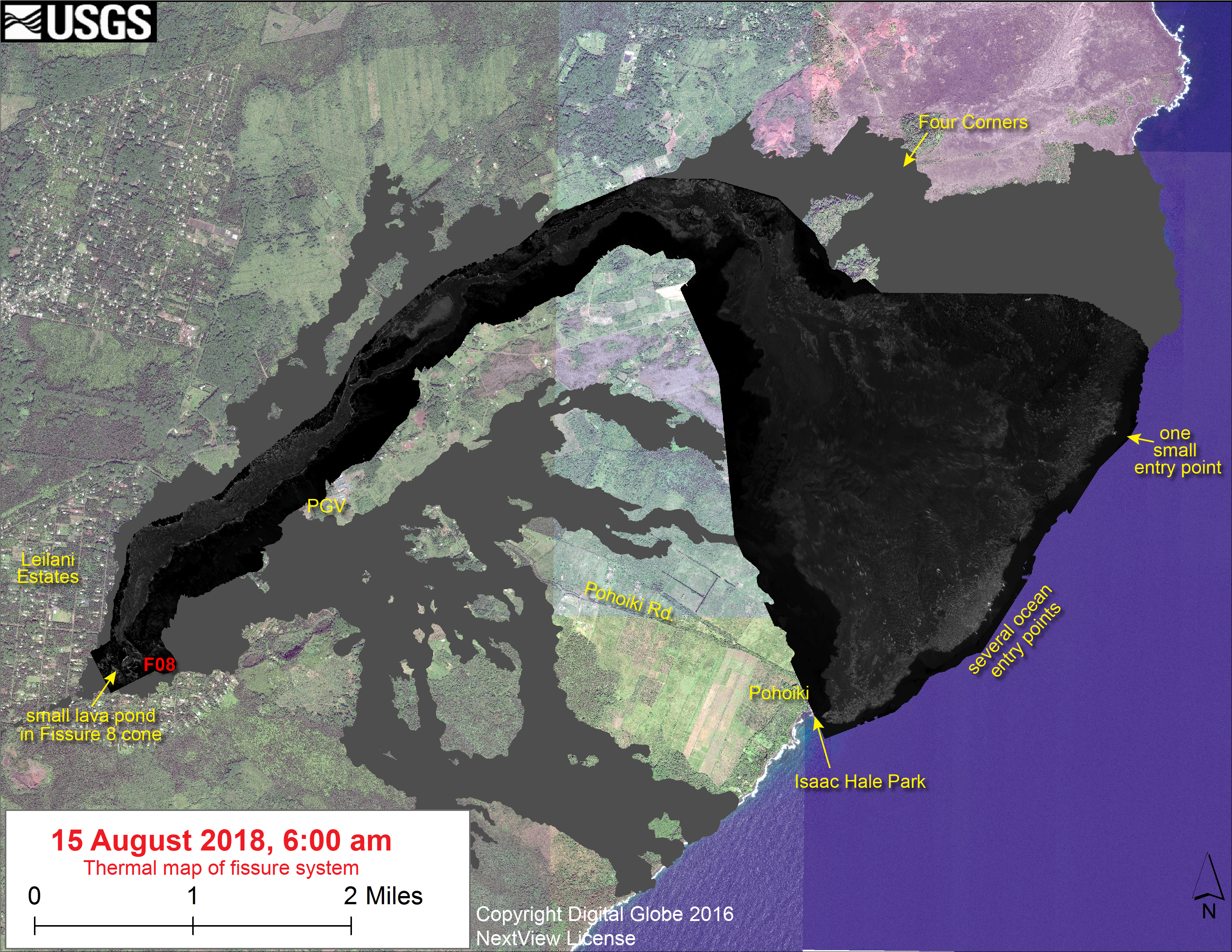
Lull in activity at Kīlauea Volcano continues; 3D computer model shows structure of fissure 8 cone; small lava pond crusting over. https://t.co/RLX9MRJI8V pic.twitter.com/CutF2PzHck
— USGS Volcanoes🌋 (@USGSVolcanoes) August 17, 2018
This Week’s Eruption Activity
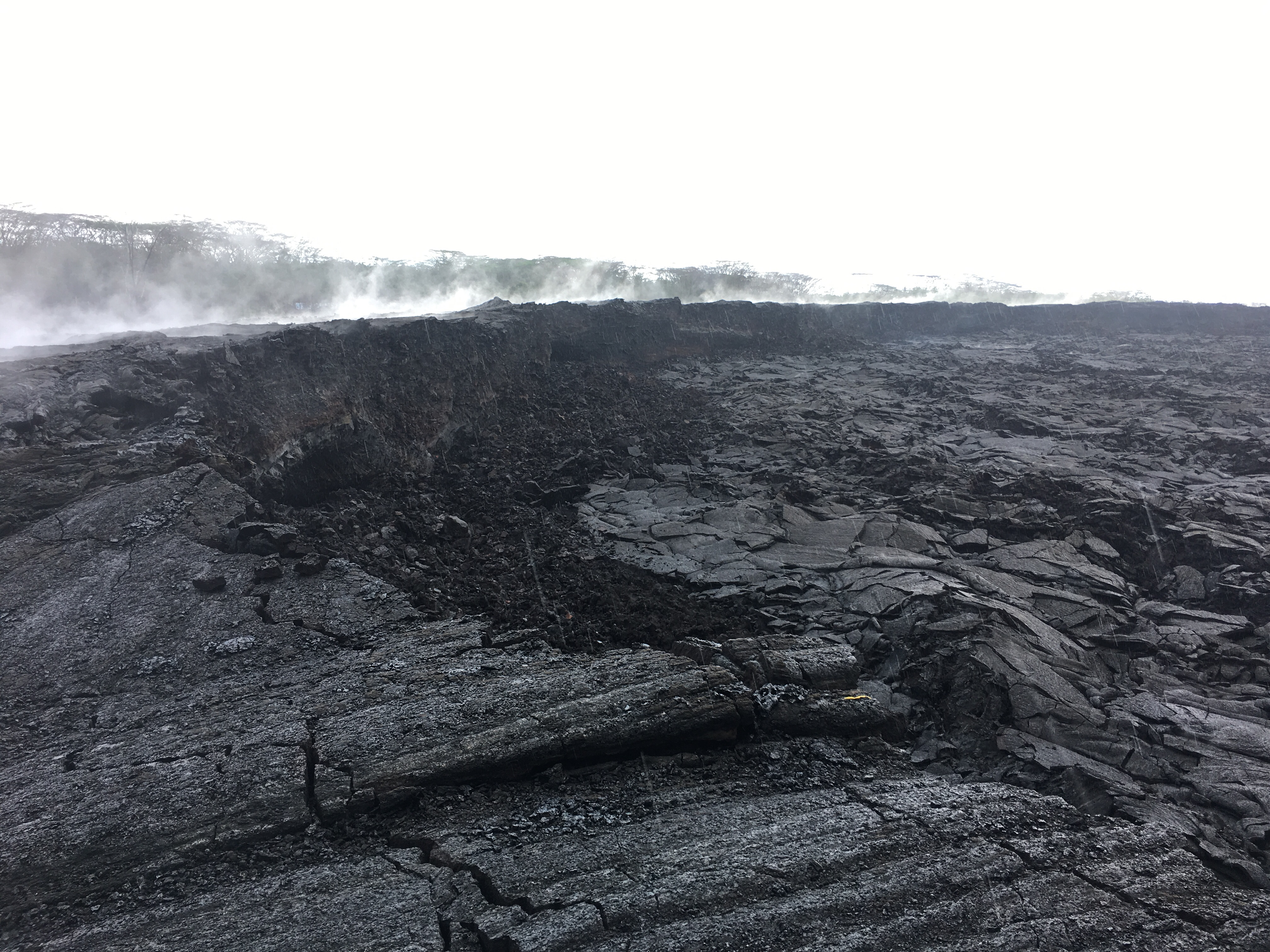
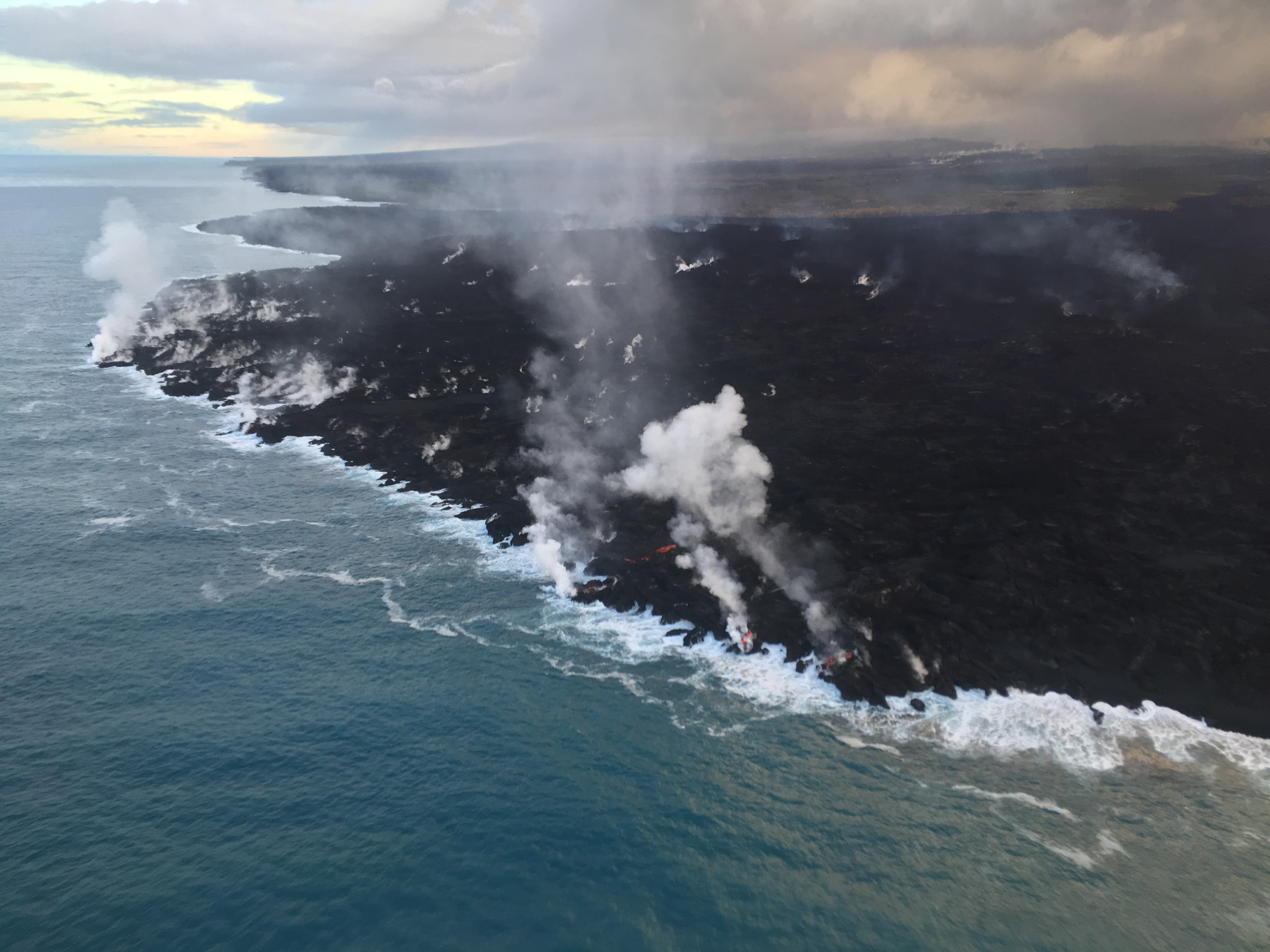
Negligible. There’s a few residual bits of lava oozing into the ocean at Ahalanui. Otherwise, there’s not much going on at the summit or LERZ.
[In case Tweet above isn’t showing, here’s the 3D Fissure 8 video on HVO website.]
In light of the reduced eruptive activity at Kīlauea Volcano over the last several days, HVO is lowering the Alert Level for ground based hazards from WARNING to WATCH. This change indicates that the hazards posed by crater collapse events (at the Kīlauea summit) and lava flows (Lower East Rift Zone; LERZ) are diminished. However, the change does not mean with absolute certainty that the LERZ eruption or summit collapses are over. It remains possible that eruption and collapse activity could resume.
[…]
Remarks: Background and Prognosis
Kīlauea Volcano has remained quiet for well over a week now, with no collapse events at the summit since August 2. Except for a small, crusted-over pond of lava deep inside the fissure 8 cone and a few scattered ocean entries, lava ceased flowing in the LERZ channel on August 6. Sulfur dioxide (SO2) emissions rates at the summit and LERZ are also drastically reduced (the combined rate is lower than at any time since late 2007).
It remains too soon to tell if this diminished activity represents a temporary lull or the end of the LERZ lava flows and/or summit collapses. In 1955, similar pauses of 5 and 16 days occurred during an 88-day-long LERZ eruption. During the Mauna Ulu eruption (1969-1974), a 3.5 month pause occurred in late 1971.
HVO will continue to record detailed visual observations and scrutinize incoming seismic, deformation, and gas data, looking for evidence of significant movement of magma or pressurization as would be expected if the system was building toward renewed activity.
Also on Friday, the National Park Service issued a media release and gave select local media a guided tour of the summit. Lots of info, and worth seeing:
This Week’s USGS Photos From Summit to Sea


USGS Report at Tuesday Pahoa Meeting
HVO Scientist-in-Charge Tina Neal gave a rundown of the “lull” in this eruption on August 14:
Transcript: “Everyone is interested in whether this eruption is really over, or if this is just a pause. And the bottom line is we just can’t answer that question with certainty yet. It’s typical for eruptions to wax and wane, and sometimes stop. In the recent history, Kilauea has had eruptions that have paused for 16 days and come back rather vigorously. And in the Mauna Ulu days, there was a pause of 3½ months before the eruption returned. So it’s very difficult to call this eruption over.
“That said, what we look for is basically monitoring data that’s showing no sign of magma accumulation or significant movement underground. And right now, that is the case in lower Leilani. We’re seeing very few earthquakes, no deformation.
“But we are still seeing very high-temperature cracks. Some of the cracks in the western Leilani area have been changing in the last week, expanding a little bit. So we’re not quite sure what that means, but it could still mean that magma is fairly shallow and still moving around, and the dike is not completely inactive. So we’re watching that carefully. Our crews are going in and measuring the cracks and checking temperatures quite frequently.
“So, we did see seismicity in the early part of this eruption as the dike was breaking the surface. And then we saw it again when it moved a little bit downrift, you may recall. Since then, it’s been a very seismically quiet part of the rift zone, and that’s probably because the vents were open, the dike had reached the surface, and it wasn’t breaking a lot of rock— and that’s what causes earthquakes.
“So in point of fact, if it were to resume activity at any of the fissures right now, we don’t expect necessarily a lot of earthquake activity. What we will see is tremor, which is the movement of magma. The other thing we should see is an infrasound signal. And that’s from our stations down there that are looking at these signals that travel through the air that point back toward sources of lava emission.
“Deformation, we may not see any change in those signals either right now, because again, the dike was to the surface. It opened the ground. It doesn’t have to do a whole lot to come back to the surface. What we’re really looking for instrumentally is sign of pressurization, and maybe uprift pressurization, if pressure begins to build. So, while I won’t rule out that we’re going to see earthquakes and deformation before the next— before a resumption, it may not happen.
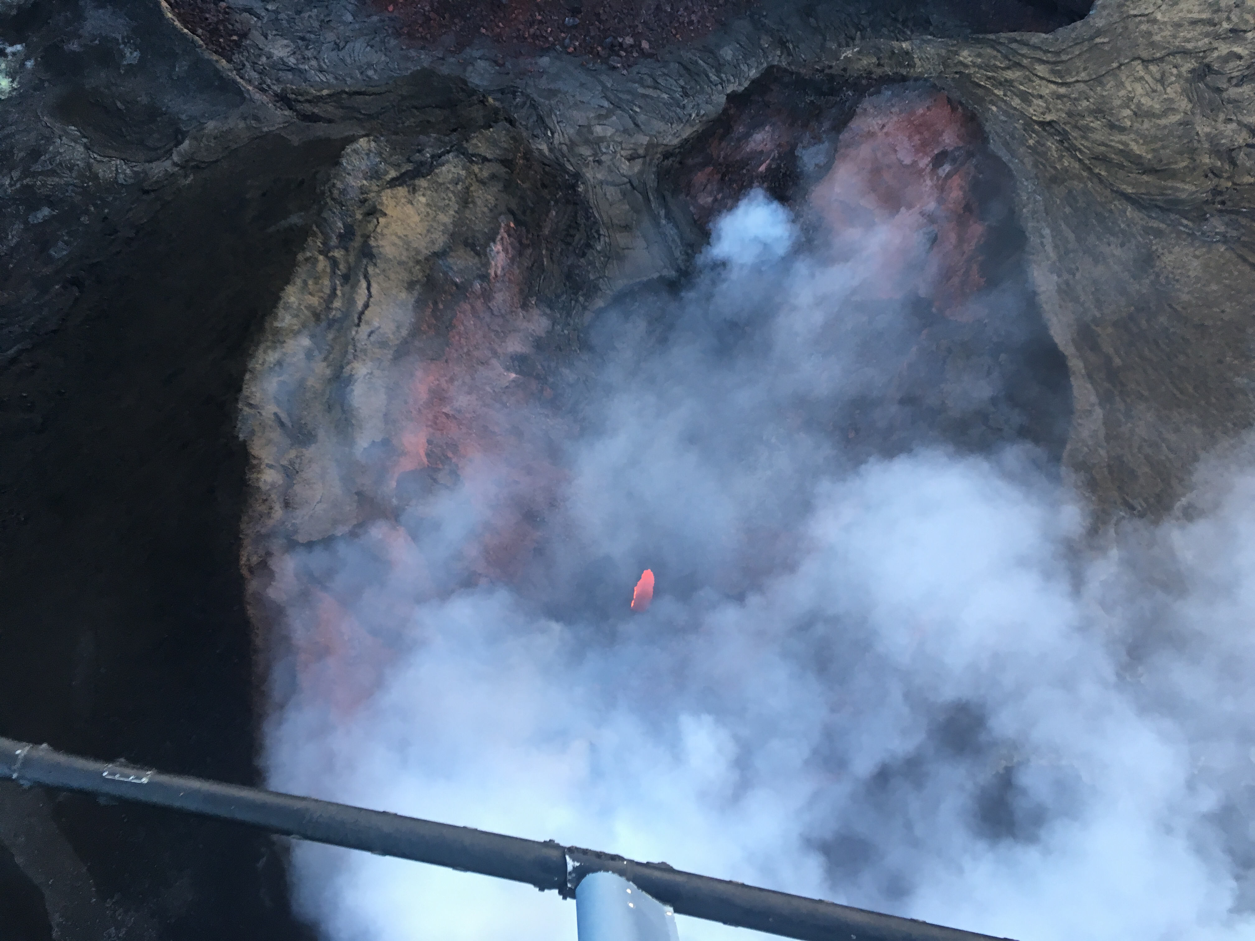
“Fissure 8 is, of course, hidden from view unless you really fly right over it. And today our unmanned aerial system flew over the vent late in the afternoon, looked down— there still was an active puddle of lava inside the crater. I’m estimating it’s 15 or 20 feet across. It’s not very big, but you can see lava moving and bubbling.
“Gas levels are way down. I think our recent measurements are well below 1000 tons per day. There is still gas coming out of Fissure 8— and that’s typical if there’s lava at the surface— and some of the adjacent fissures.
“So as the vents cool down, and water gets involved, you start to produce more H2S, so that’s probably why people are smelling it. And remember the human nose is extremely sensitive, so, smelling H2S at extremely low levels. There was a time when the gas emissions from Pu’u O’o went up very briefly. And now they’re back down to what they’ve been for a long time. But tomorrow— I said the other day that really, right now, Kilauea is putting out less SO2 than we’ve seen in a long time, certainly in 10 years.
“So, yesterday on our helicopter assessment, we did see fingers of lava still pouring— oozing into the ocean. And so that’s just the lava flow draining. It was a very large volume lava flow that was active, so it’ll take a little while for all that liquid interior to slowly seep out and solidify.”
[Q: Any comments on Pohoiki, what we’re seeing there, amazing geology?]
“It is amazing geology in motion, sedimentary geology. The last picture I saw, I think, showed the sandbar had built out across the entire mouth of the harbor. And so that’s sand that was developed and is being developed up-current to the east, by where these lava flows went into the ocean. And that could be a sedimentation pattern we see for a long time.”
[Q: Could that possibly ever become a warm pond?]
“The pond that has been created by the sandbar? I don’t know. I know that nearby there was a warm pond. And if there are warm springs coming in there, I suppose it could, but I’m not aware that there are springs leaving that little part of the coastline.
“We’re still monitoring the volcano very closely. We’ve got field crews there during the day. At night, we’re on call. We’ve got someone down at Civil Defense still from 6 in the morning until 10 at night, watching the data very carefully. So we’re ready to react very quickly if something happens. And I think that’s just another point I’d like to emphasize, is that a resumption of activity could happen very quickly. So that’s one reason we’re staying vigilant. And people who are in the area should always stay posted about what’s happening and be ready to move quickly.”
Aug 16 Mick Kalber Overflight Video
Very clear view down into Fissure 8 around timestamp 2:00. Also a little time spent checking out borders of flows and surviving houses just beyond them:
Bruce Omori’s Aug 16 Photos
Observations on this overflight plus 16 photos posted on his Facebook, including:
Thursday, Aug 16, 2018, 6:00 am – Kilauea's lower east rift zone overflight: The tiny island is once again an island again. 🙂
Posted by Extreme Exposure Fine Art Gallery on Thursday, August 16, 2018
Thursday, Aug 16, 2018, 6:00 am – Kilauea's lower east rift zone overflight: A wide view of the stretch of new coastline, with the dwindling ocean entry.
Posted by Extreme Exposure Fine Art Gallery on Thursday, August 16, 2018
Thursday, Aug 16, 2018, 6:00 am – Kilauea's lower east rift zone overflight: The braided channel severely affected the…
Posted by Extreme Exposure Fine Art Gallery on Thursday, August 16, 2018
Thursday, Aug 16, 2018, 6:00 am – Kilauea's lower east rift zone overflight: Just a tiny bit of glow was visible…
Posted by Extreme Exposure Fine Art Gallery on Thursday, August 16, 2018
Rest of Bruce’s photos and notes here.
From Other Scientists
- Eric Klemetti of Rocky Planet Blog reviews the state of the eruption in, “Is the Kilauea Eruption Winding Down?”
From Other Official Agencies
According to @USGSVolcanoes "It is too soon to tell if this change represents a temporary lull or the end of the LERZ eruption and/or summit collapse activity." What we do know is the summit of Kīlauea is forever changed. Check out this map of fault lines and subsidence. pic.twitter.com/t1zKxTOo5D
— Hawaii Volcanoes NPS (@Volcanoes_NPS) August 16, 2018
On Thursday 8/16/18, Hawaii Civil Defense issued what may be their final alert for this eruption:
At this time, the following access policies and restrictions are in effect:
- The entire flow field, including all fissures and lava features, is extremely dangerous and remains off limits.
- Highway 137 roadblock near MacKenzie State Park and Highway 132 roadblock between Nanawale and Lava Tree State Park remains closed to the public.
- Properties not destroyed, but isolated by lava on E. Pohoiki Road, Malama Ki Place, Halekamahina Road, and E. Pahoa-Kapoho Road are accessible to residents with Civil Defense authorization only.
- Leilani Estates access is limited to residents. A Civil Defense Access Placard is required to enter Leilani Estates. Property on, and east of Pomaikai Street is in the mandatory evacuation area. For access to this area, residents must make an appointment with Civil Defense for an escort.
- Access to Papaya Farms Road, Noni Farms Road, Railroad Avenue, the Mail Box area, and Cinder Road is limited to residents. A Civil Defense Access Placard is required for these areas.
- Placards are available Monday through Friday at the Civil Defense office in Hilo, located at 920 Ululani Street from 8 AM to 4 PM.
Civil Defense continues to monitor the situation. However, this will be our final daily Kilauea Eruption Update unless activity significantly changes.
On Sunday 8/19/18, Civil Defense issued an advisory for Hurricane Lane, currently Cat 3, 890 miles ESE of Hilo, moving west at 15mph. No watches/warnings have been issued yet by Central Pacific Hurricane Center. A good place for the latest hurricane news is @NWSHonolulu on Twitter.
Mayor Harry Kim’s office has been sharing BigIslandVideoNews and videos from Mick Kalber to keep residents informed. Also recommended:
If you haven't seen this already, KHON2's powerful documentary, Kilauea, Reshaping the 'Aina, is must-viewing. Click for the link: https://t.co/C0oMzNzFkQ
— Mayor Harry Kim (@MayorHarryKim) August 15, 2018
From Local News Media Outlets
- HNN: “As Kilauea eruption cools, officials downgrade volcanic threat level on Hawaii Island”
- HSA: “Volcano alert level for Kilauea lowered to watch”
- HCB: “Lava That Destroys On Land Spurs New Life At Sea”
- HTH: “HVNP to reopen in phases, park spokeswoman says“
- HTH: “Park representatives hold talk story session with Pahoa residents” [discussing future of HVNP park]
- HCB: “As Fire And Lava Diminish, Volcano Village Still Struggles“
- BIVN: (Video & brief article): “Eruption Meeting Held In Pahoa — Q&A Session“
- HTH: “Leilani residents want more transparency in decisions affecting neighborhood“
- HSA: “Big Island residents hopeful pause in Kilauea Volcano flow will last“
- HNN: “Big Island residents want an end to constant ‘disruptive’ drone of helicopters“
- BIVN (Video & brief article): “Passions Flare At Tour Helicopter Noise Meeting”
- HTH: “New panel to be charged with finding solutions to helicopter noise“
- HPR (audio report): “Helping Hand – Hawaii Lava Flow Animal Rescue Network“
- HSA: “Mayor Harry Kim pushes his limits amid Big Island disaster“
- HNN: “Hawaii Volcanoes National Park to host ‘talk story’ sessions for Big Island residents”
- HNN: “As Kilauea settles, Kohala resorts 100 miles away focus on getting back visitors“
- HNN: “Less-visited area of Hawaii Volcanoes sees more activity”
- HSA: “Visitors to less popular areas of Hawaii Volcanoes grow tenfold“
- HTH: “Closure of main part of national park has given rangers more time to improve former ranchlands“
- HSA: “FEMA, SBA assistance deadline for Big Isle residents extended“
- HTH: “County asks lawmakers to mull $680 million disaster recovery plan“
- HSA: “Hawaii island’s $671 million lava-recovery plan needs tough debate“
- HSA: “Lava insurance paying off for Puna geothermal plant owner
- HTH: “Additional lawsuit against insurer filed“
- HTH: “Eruption has little effect on turnout“
Yes, it snowed today in Hawaii. And yes, residents and tourists in the Aloha State should prepare for possible impacts from a hurricane in the coming days. How do you say "wild" in Hawaiian? #HIwx https://t.co/JbPbt4OJdg
— the Weatherboy (@theWeatherboy) August 19, 2018
- And Dispatches From Volcano muses on drop in quakes but urges thoughtfulness, not rushing, to plan rebuilding (and spending tons of taxpayer dollars). Another great comparison map of earthquakes Thursday vs. last month. General reflections on the eruption Saturday, as well as ways to “reset” the park, and a lovely native Hawaiian song with translation to encapsulate how Kilauea’s face has and has not changed.
HVO/USGS On Social Media
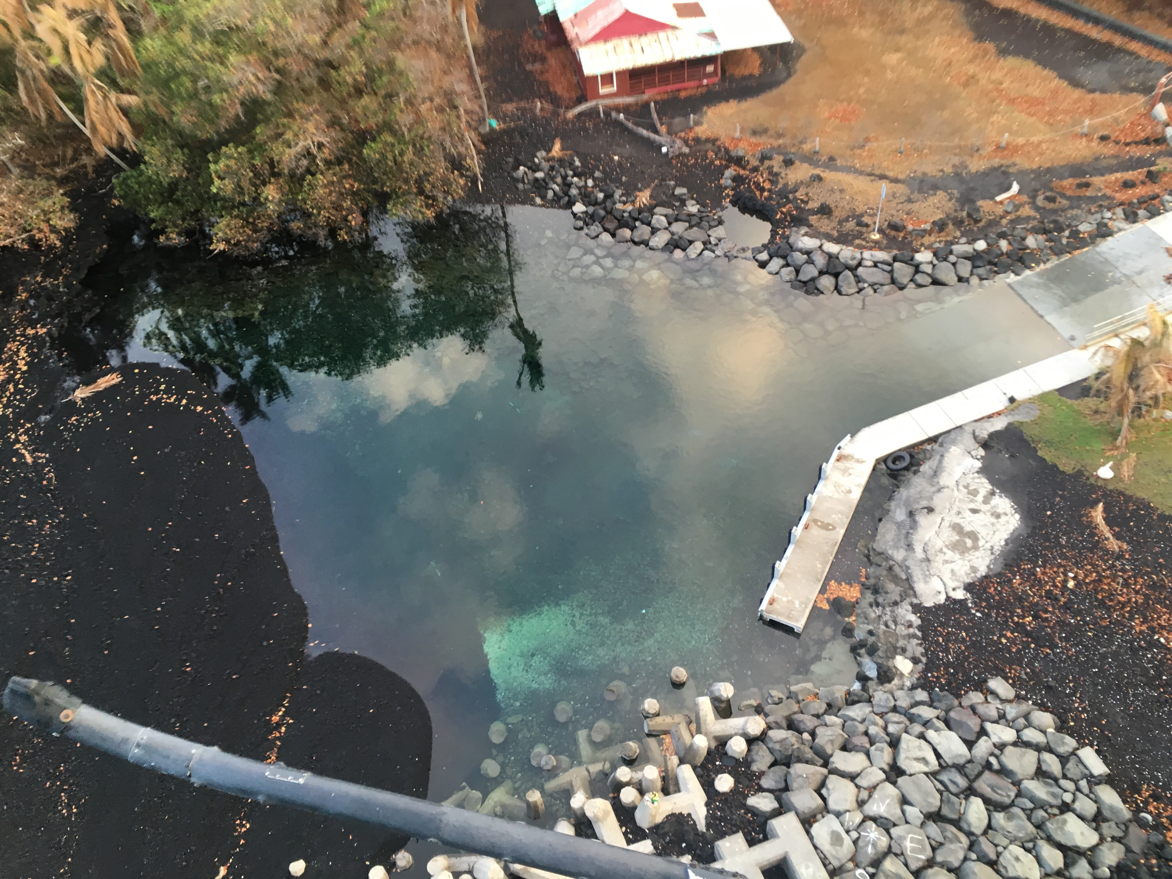
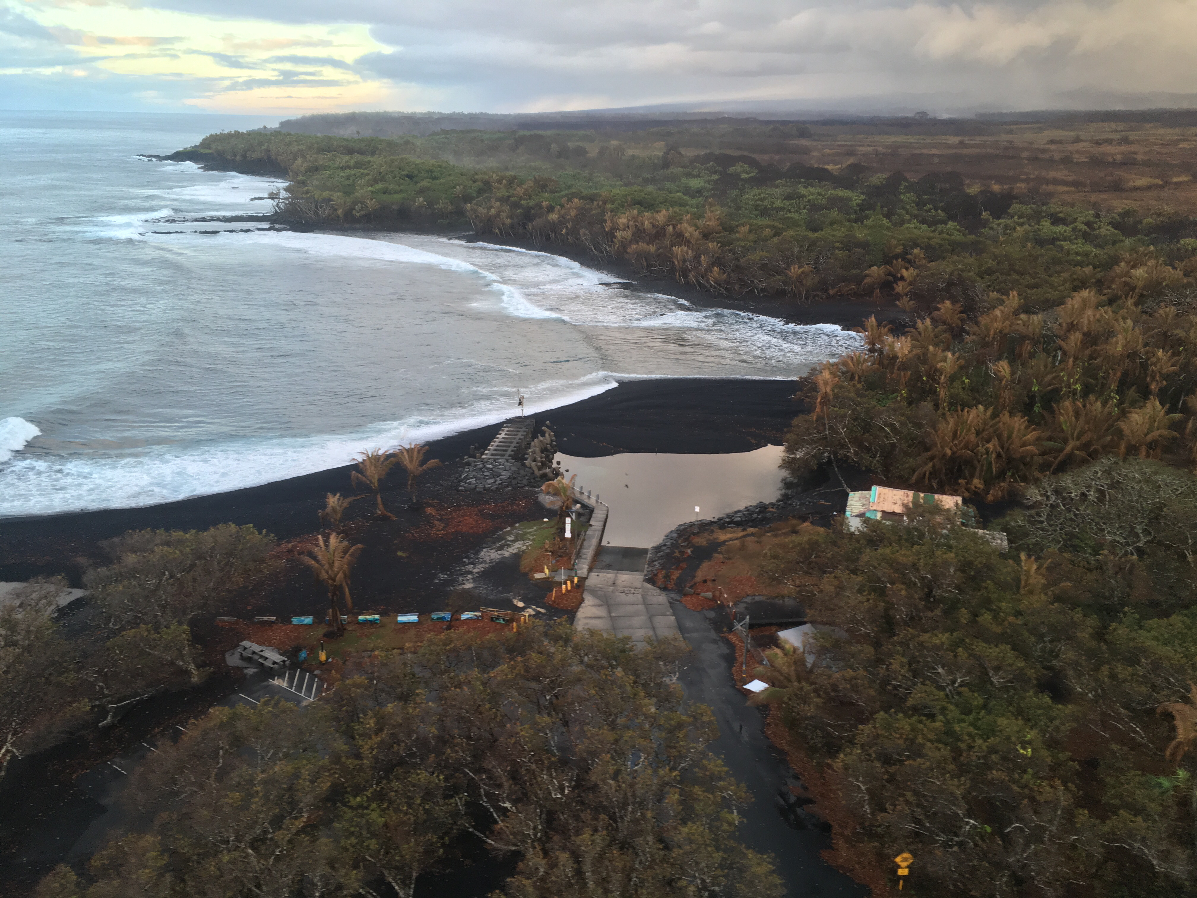
That's a good question! It's not our call, so we don't know. We suppose it depends on how useful the boat ramp still is given that the area is cut off by lava flows. The turtles seem pretty happy to hang out there, though.
— USGS Volcanoes🌋 (@USGSVolcanoes) August 18, 2018
Wow. Apart from a few basic questions like “Is it over?” which you could answer as well as they can, USGS social media hasn’t had much in the way of Q&A this week. Let’s try their Facebook.
Earlier today, USGS: “There is no incandescence in fissure 8.”
[Q: Tiltmeters/GPS monitors seem to be down on HVO website: temporary, or permanent?]
USGS: “There are electrical issues with the servers, but we are working on them. Everything should be back up and running by Monday.”
[Another Q about live feed webcam]
USGS: “The live feed from the old Hawaiian Volcano Observatory building is down. No one has been to the building to restart the system. We hope to get it up and running again.”
[Comment: This must be “a dream” for HVO/USGS scientists!]
USGS: “We are indeed gathering a mountain of data on this eruption, and we’ll be working on it for a long time to come. But while it’s ongoing, we’re also still focused on safety and situational awareness, so we can help Civil Defense and others protect everyone affected.”
[Q: Was there an explosion at Pu’u O’o Friday?]
USGS: “No, there was no explosion at Pu’u ‘O’o. There has been intermittent steaming, which occasionally creates clouds above the vent.”
[Followup: What causes intermittent steaming?]
USGS: “The rocks there are probably still hot, and Pu’u ‘O’o is still connected to Kilauea’s plumbing system. So, it could be a combination of meteoric water and gases from whatever magma is left in the system.”
[Q: HVNP status said eruption could resume at any moment without warning.True?]
USGS: “We do expect to see some seismicity prior to a reactivation of activity, either in the East Rift Zone or at the summit, but it could happen quickly. At the beginning of the eruption, fissures opened (and fissure 8 reactivated) very quickly, and we don’t want to have a situation where people are put in danger by fast-moving lava or more large summit earthquakes. Despite the lull, we’re keeping a close eye on everything and will let everyone know if new activity starts!”
[Q: When the 1971 Mauna Ulu eruption paused, were there any signs it might not be over?]
USGS: “The ~3 month pause occurred during the 1969-1974 Mauna Ulu eruption. In mid-October, the lava lake at Mauna Ulu disappeared from view and observers surmised that the eruption was finished. But, Kīlauea’s summit was inflating as Mauna Ulu hibernated, indicating pressurization of the volcano’s plumbing system. Around February 3, 1972, lava began to enter the summit crater of Mauna Ulu. In the next 2 days, lava spilled from the crater into the trench, moved to the east end of the trench, and entered the lava tube into ‘Alae Crater. The Mauna Ulu eruption had resumed. During the next 15 months, lava frequently spilled on the surface from the overflowing crater lake, building the shield higher. The eruption ended July 22, 1974.” https://volcanoes.usgs.gov/volcanoes/kilauea/geo_hist_mauna_ulu.html
More From Local Photographers
Andrew Richard Hara has a slideshow of 10 great LERZ photos from August 16:
Go to his instagram to see the rest here (hover over photo to get “next” arrow)