June 6: Summit Explosions Explained (And Predicted!)

USGS/HVO photo of Fissure 8, spatter cone and rainbow, June 6.
Today’s Eruption Update:

Last night, USGS scientist Steve Brantley explained the current eruption in an informative 10 minute talk. I transcribed it as a separate post, but here’s a rough summary: Magma heading down to the Lower East Rift Zone is causing the summit to deflate. Deflation is causing a pattern of more and more earthquakes over 30-50 hours until the summit releases the strain with an explosion, accompanied by an ash cloud.

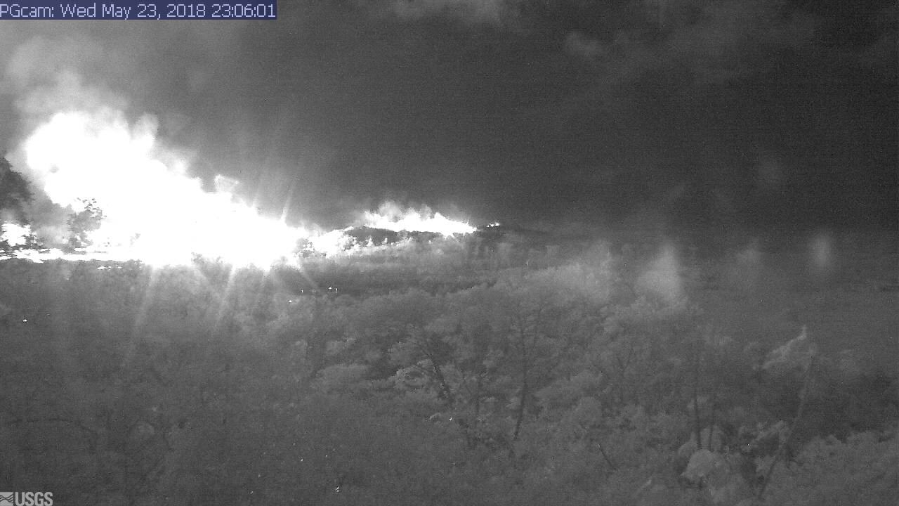
Sure enough, there was an M5.6 explosion and 10,000 foot ash cloud at 4:32pm. HVO’s Twitter account had a great impromptu Q&A session about it (see below).

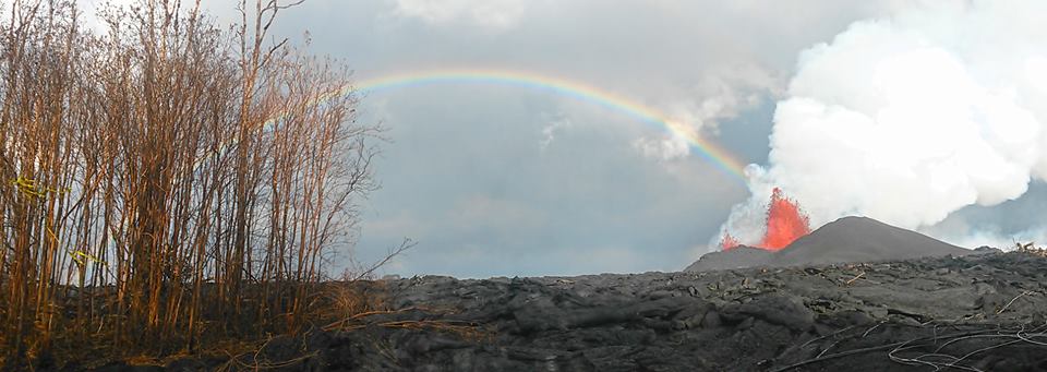
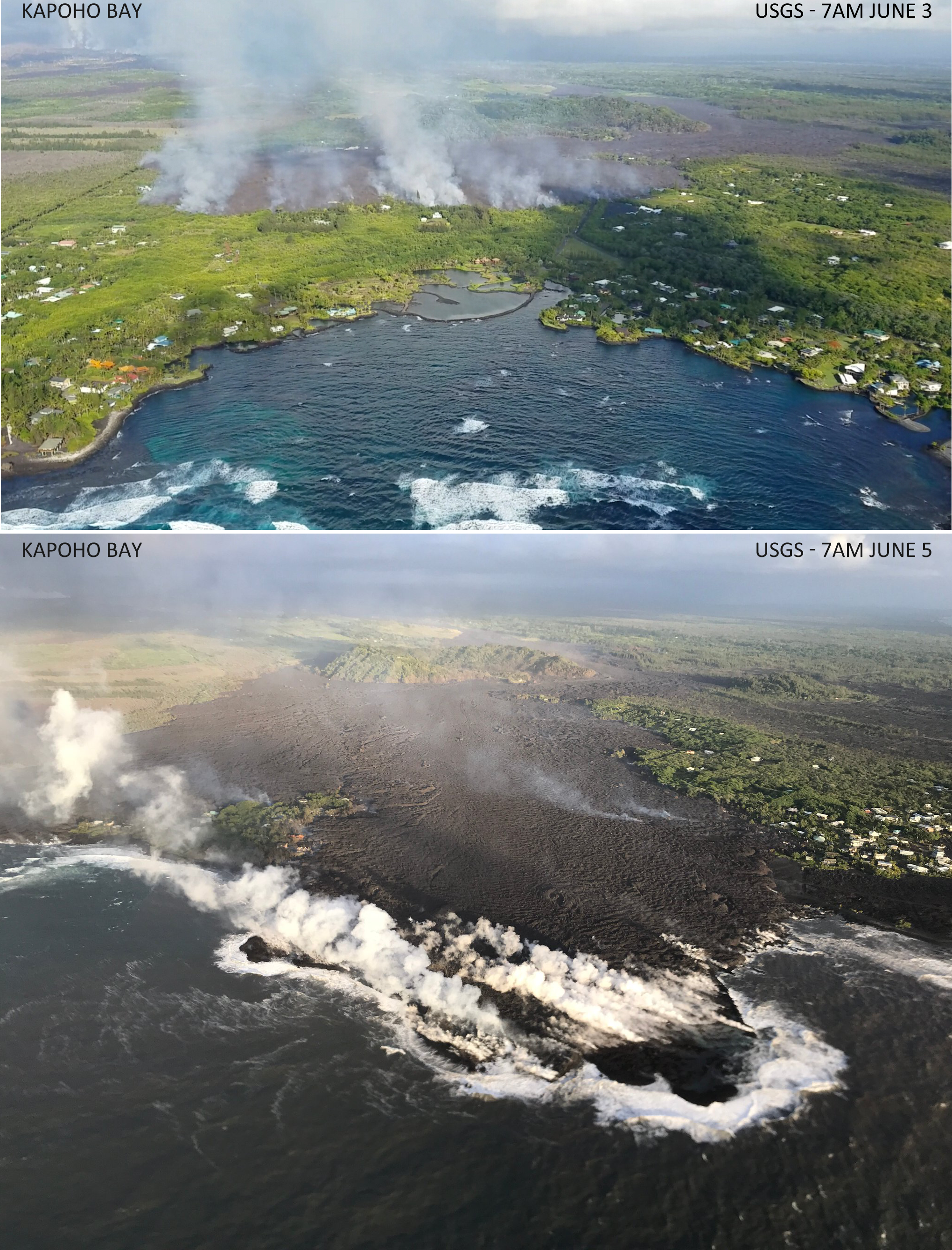
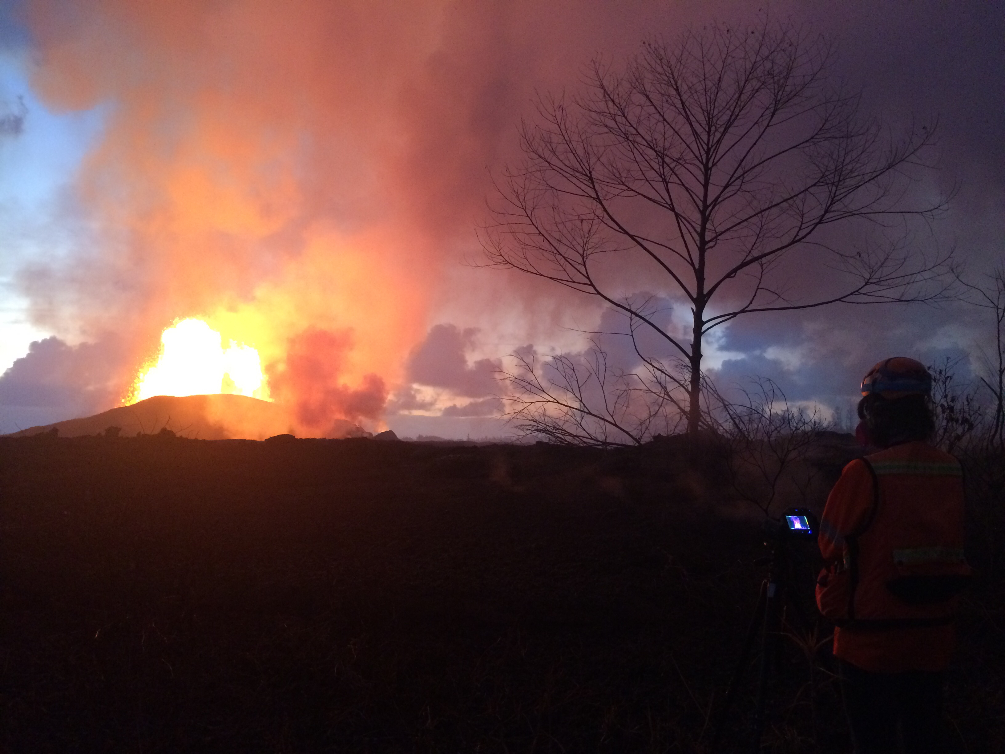
Meanwhile, down in the Lower East Rift Zone, Fissure 8 shows no signs of slowing. It’s wiped out Vacationland and nearly all of Kapoho Beach Lots, and is continuing to create new (crumbly, hazardous) beachfront real estate.

USGS has also been posting some striking imagery today.

Video description: “HVO’s mid-day overflight on June 5 shows ongoing partial collapse of Halema‘uma‘u at the summit of Kīlauea Volcano. To the north of the former visitor Overlook parking area (closed in 2008) is the site of the former lava lake—now a deep hole piled with wall-rock rubble. The western portion of Halema‘uma‘u has moved down and toward the center of the crater as new cracks form on the caldera floor to the west. Kīlauea’s summit continues to subside due to withdrawal of magma towards the volcano’s East Rift Zone.”

They’ve also posted drone footage of Fissure 8 lava flow on June 3. Houses give a sense of scale:

(Link to video description)

Here’s this morning’s USGS helicopter overflight of Fissure 8:

More images, lots of great geology info below the cut. But first, a 2-minute USGS briefing, since we skipped yesterday’s:

Continue reading June 6: Summit Explosions Explained (And Predicted!)

June 5: Steve Brantley (USGS) Sums Up Eruption So Far

At a public talk in Pahoa, Hawaiian Volcano Observatory Deputy-Scientist-in-Charge Steve Brantley gave a 10-minute talk on the 2018 Kilauea eruption sequence so far.

I was going to summarize it in my June 6 Kilauea daily digest. However, it’s so useful I’ve transcribed it in full below.

The full community meeting is archived here, with Steve Brantley’s presentation starting at 44:30. BigIslandVideoNeed has excerpted it below, but they don’t usually show the slides he was showing. I’m going to be putting those back in, matching or approximating the photos he selected.

Steve Brantley, HVO/USGS: “Good evening and thank you for coming out tonight. […]

Continue reading June 5: Steve Brantley (USGS) Sums Up Eruption So Far

June 5: Kapoho Bay Is No More

Today’s Eruption Summary:
Kapoho Bay Before and After filled with Lava
USGS overflights of Kapoho Bay, morning of June 3 and June 5.

Lava reached Kapoho Bay on Saturday night, around 10:30. By Tuesday morning, it was Kapoho Point. There were hundreds of homes here, plus farms, tidepools, and marine life.

There’s really not much more one can say.

(See Mick Kalber’s observations/notes for this video)

There was another small predawn ash explosion up at Kilauea’s summit, where we can now watch the changes to Halema’uma’u Crater (see below). HI Civil Defense, the Dept. of Health and EPA have set up a new network of sensors to monitor and report air quality in realtime, which should help the rest of the island.

But Vacationland and Kapoho Beach Lots have now followed the 1960 village of Kapoho into memory.


Of course, that’s not the whole story for today. There’s new images and videos, USGS updates and info, articles on the eruption’s impact from local Hawaiian news outlets, and eyewitness reports and reactions on social media. So here’s the usual daily roundup of Kilauea eruption news.

Continue reading June 5: Kapoho Bay Is No More

June 1: Halema’uma’u Exposed

Today’s Eruption Summary

Fissure 8 continues to pump out vast amounts of lava, although it’s slacked off a tad from yesterday’s 260-foot display. One of its fingers burned a building or two at PGV. Other lobes closed in on Kapoho throughout the day, touching Highway 132 again half a mile north of Four Corners at 3:30. Fissure 18, which has been sending a flow east and down towards the ocean, has pretty much stalled apart from some small breakouts. Authorities were ordering Kapoho-area residents out today before lava cuts their only remaining road to the rest of the island.

Update: just as I was about to hit post.

(That’s a photo of Four Corners, which is the intersection of  Hwy 132 & 137. Apparently the lava’s started using 132 as a shortcut again.)

The summit has been steaming and vogging away, but the overlook vent has now been choked with debris falling from its walls. Ash explosions have nearly stopped since the 11am May 30 ash eruption that rose 12,000 ft.  Scientists are trying to figure out whether this means the main explosive phase is finished, or whether it’s going to build up enough pressure to blow out the clog. (That said, the crater has not “fallen quiet,” as many non-Hawaiian news stations claimed today. According to @NWSHonolulu, there was a minor “burp” of ash just after 1:30pm.)

Fantastic Kilauea Photo Gallery

@cheaptarts pointed me to photographer Andrew Richard Hara’s amazing Kilauea Instagram. A couple examples:

20180522 @ 03:30 HST – Methane field flames simmer in new cracks from Fissure 15 and 19 open up on the southeastern side of PGV, burning a State of Hawaii warehouse next to Pohoiki Road. Slow moving pahoehoe begins to approach PGV land at a crawl. . If you are worried about PGV, please remember that there are 23 fissures that have and emitting HF, H2S, and SO2 gases throughout this entire eruptive series. I'm not an expert by any means, but I try to remind myself that the gases that could be released at PGV are already being released into the atmosphere as we speak, outside of PGV's property. . For those who are wondering, I have official permission to be documenting this area. All areas that I have documented throughout this eruptive series have been through approved with legal access. Please kokua and do not attempt to trespass in areas unless official approval has been granted. . Many areas are now becoming inaccessible and the majority are dangerous due to volcanic hazards. . My respect and best wishes go out to the neighborhood of Leilani Estates, Lanipuna Gardens, and the areas within and between Kapoho. . #leilani #lava #pohoiki #lanipunagardens #bigisland#lavaflow #hawaii #geology #fissure #volcano @hawaiinewsnow

A post shared by Andrew Richard Hara (@andrewrichardhara) on

20180529 @ 15:30-19:30 HST – Fissure 8 on Luana Street . Moderate southwest trade winds shifted gaseous plumes of smoke and gas while Pele’s hair, light fragments of cinder, and reticulate showered from the skies up to five blocks (up to Alapai Street) in radius F8’s eruptive site. F8 generated massive channels of lava extending partially east and north over older flows on Luana Street. Nearby, F24 sputtered glimpses of orange lava a few feet in the air and is unlikely to be contributing any major part in F8’s aggressive effusion rate. Massive bodies of new pahoehoe lava beds radiated an intense amount of heat, keeping ambient temperatures consistently within ~90°F at our location. . All areas that I have documented throughout this eruptive series have been through approved with legal access. Please kokua and do not attempt to trespass in areas unless official approval has been granted. The majority of my efforts are without pay and all expenses are out of pocket. The content shared is being shared without cost to our local news networks for community awareness and support. Some footage does help to pay a very small portion of my expenses. . Many areas are now inaccessible and the majority are dangerous due to volcanic hazards. . My respect and best wishes go out to the neighborhood of Leilani Estates, Lanipuna Gardens, and the areas within and between Kapoho. My heart especially goes out to all of my friends who have lost their homes in this fissure eruption. I am at a loss of words. _____ #leilaniestates #eruption #bigisland #helicopter #hawaii #aerial #volcano #lanipunagardens @hawaiitribuneherald @hawaiinewsnow @natgeo @milekalincoln @bruceomori

A post shared by Andrew Richard Hara (@andrewrichardhara) on

Pretty, huh? Okay, let’s get down to the day’s Kilauea news, views, and eruption information:

Continue reading June 1: Halema’uma’u Exposed

May 31: One Month On

It’s been exactly a month since the first lava started emerging from fissures in Leilani Estates on May 3. And what a month it’s been.

USGS Caption: Crews make visual observations of activity at fissure 8 around 5:30 am HST. Fountain heights this morning continue to reach 70 to 80 m (230 to 260 ft above ground level. The fountaining feeds a lava flow that is moving to the northeast along Highway 132 into the area of Noni Farms Road. Full-sized)

The Lower East Rift Zone (LERZ) eruption has built in intensity by stages. Earthquakes, cracks, fissures, toxic gasses, spattering lava, larger and longer lava flows, and increasingly voluminous fountains have slowly engulfed two subdivisions and the forests and fields of lower Puna. They’ve heaped up acres of spatter ramparts, thick lava flows, overflowing ponds and rivers creeping down to the ocean. They’ve emitted a’a and pahoehoespatter and lava bombs, Pele’s Hair and Pele’s Tears, tephra/pyroclasts and cinders, vog, laze, and glowing blue flames.

Meanwhile, Pu’u O’o on Kilauea’s shoulder drained and died after a historic 35-year-long eruption. The summit lava lake in Halema’uma’u Crater followed suit, draining away more gradually but no less dramatically, with rockfalls and earthquakes and clouds of ash rising as high as 15,000 feet. Downwind communities are suffering from its ash and vog. The threat of steam explosions sending rocks flying half a mile has forced the closure of Hawaii Volcanoes National Park. That, coupled with jittery tourist cancellations, has struck almost as big a blow to the rest of the Big Island as lava has done to a few square miles of Puna.

The USGS and Hawaii Civil Defense have done a herculean job of monitoring, informing, warning, and moving people out of harm’s way in this fast-moving and complex natural disaster. And locals are rallying as best they can to support one another.

Today’s Eruption Summary

Kilauea’s still pulling some (alas, not all) of its punches. Early Wednesday morning, Fissure 8’s lava flow was surging towards Four Corners in sprints up to 600 yards an hour, causing emergency officials to go door to door ordering emergency evacuations. Luckily, it’s slowed, although it’s still inching towards the last remaining road in and out of Puna. People have had two precious days to go back and rescue pets and possessions before the lava cuts them off.

Meanwhile, the summit today was steaming with minor ash explosions. The USGS just released another drone survey of Halema’uma’u filmed May 26:

See caption on USGS website, and compare with drone footage of May 21.

USGS STATUS UPDATE: MAY 31 9:30 AM

Continue reading May 31: One Month On

May 31: 6PM Eruption Update – Conference Call

Normally I tuck the USGS media conference call into my digest for the day, but my notes are so long I decided to put this in its own post.

Summary: Eruption is continuing with no signs of stopping. Wendy Stovall gives all kinds of geeky tidbits about temperatures, heights, where the magma is coming from, plumbing system of Kilauea. She emphasizes that Kilauea receives a “continuous supply of magma from the deep mantle” thanks to its mantle plume. Scientists are starting to discuss calling this a new eruption, but their focus right now is on collecting data and getting info to Civil Defense.

Full notes (sorry they’re a little rough, but you’ve got the gist) below cut:

Continue reading May 31: 6PM Eruption Update – Conference Call

May 23: Blue Flames? Now You’re Just Showing Off

Kilauea’s chief resident has found another way to amaze and/or injure people reckless enough to get too close to her redecorating:

I had a hunch the Lower East Rift Zone webcam would be interesting tonight. I wasn’t disappointed:

I see what they mean about the Leilani fissures further west (uprift, towards the camera) reactivating today.

Edited to add: Yikes.

It’s 11:06 PM in Hawaii; second screengrab an hour or so later.

I was about to hit post, when I saw erstwhile reporter Mileka Lincoln and her crew posted this. Wow.

(recorded just an hour ago at time of this post.)

Now, let’s have the evening roundup of poignant news, amazing views, and interesting science…

Continue reading May 23: Blue Flames? Now You’re Just Showing Off

May 23: USGS Presentation on Puna Lava Eruption So Far

Tuesday evening, USGS Volcanologist Steve Brantley gave a  presentation in Pahoa High School. A lot of it is fairly simple, recapping the eruption for residents of Puna. I’ve covered most of what he does in previous posts. But there are a few new tidbits.

His takeaway is worth seeing if you don’t read/watch the rest:

…until that balance is reached, or something else changes, we expect magma to continue moving from the summit reservoir into the rift zone and further down into the Lower East Rift Zone. So that suggests that we’re in it for the long haul. We don’t know how long this eruption’s going to last, but for now, it looks like it’s just going to continue.

Full transcript below the cut.

Continue reading May 23: USGS Presentation on Puna Lava Eruption So Far

May 22: Reactivated Fissures Near Geothermal Plant

News media have finally gotten wind of Civil Beat’s livestream. Some have gotten the homeowner’s permission to film broadcasts on the same porch, so you may hear them if you tune in. At other times, the homeowners or friends they’ve let use the house stop by. It’s surreal yet oddly comforting to hear the homey noises of people, a pet parkeet (?), and wild chickens outside while towering, terrifying yet magnificent lava fountains boom and chuff.

As for the big picture, we’re starting to settle into a routine with Kilauea’s ongoing double eruption:

(1) Lava in Lower East Rift Zone

  • Lava fountains/flows in the Lower East Rift Zone continue vigorously, claiming more land and displacing more residents in Lower Puna.
  • Some fissures stop, but others reactivate. See HVO maps for what’s active.
  • Coast guard, police are trying to keep spectators away from lava entry into ocean; toxic “laze” plume from lava/seawater interaction is dangerous.
  • Puna residents are concerned about lava now encroaching on Puna Geothermal Venture site, because PVG’s lack of transparency and tardiness in capping wells has not been reassuring. (see HNN reporter Mileka Lincoln’s brief, damming synopsis). Lava-breached wells might emit toxic hydrogen sulfide.
  • Leilani Estates, where fissures started, doesn’t have much erupting now but cracks in some roads are now chasms (photo).
  • Lava is now faster, hotter, more voluminous due to clearing out old lava from 1955 that was pooled under rift zone; now it’s fresh lava from drained Pu’u O’o.

(2) Kilauea Summit Ash Explosions

  • Minor ash explosions continue intermittently at Kilauea’s summit crater, Halemau’ma’u. Between explosions, white plume of steam seen on webcams.
  • This morning, another ash explosion, 10,000 foot cloud, 3:30 AM. Here’s this morning’s Civil Defense ashfall warning with advisory for Kau.
  • See NWSHonolulu on Twitter for ashfall advisories.
  • We don’t know if crater has ejected more “ballistics” (flying rocks) since USGS scientists aren’t risking personnel by entering the possible “flying rocks” zone. Right now they’re working from a temporary base of operations in Hilo.
  • Hawaii Volcanoes National Park remains closed, not only to keep public out of range of flying rocks, but because of earthquake damage to trails and some park structures. These need to be assessed/repaired.
  • Park Rangers have set up in Hilo Bayfront to educate public about this historic eruption.

Oh look, another hazard from lava entering ocean: WATERSPOUTS.

And even when fissures don’t spout lava, they can still be dangerous: