Eruption Summary: the Lull continues
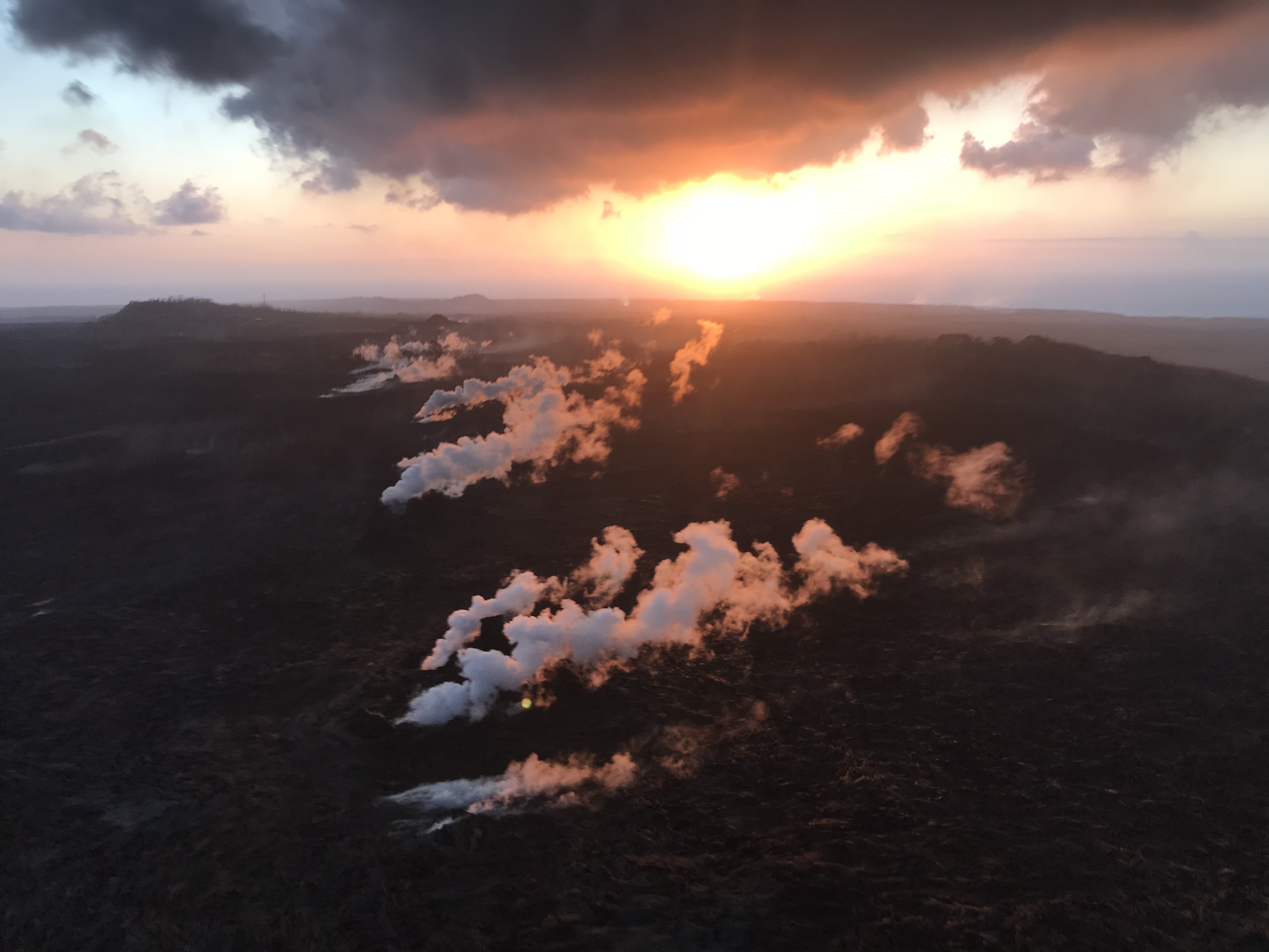
Fissure 8 is still emitting a gas plume, and lava circulates weakly within the cone. Residual lava is still draining into the ocean near Pohoiki. Gas emissions at the summit, Pu’u O’o, and even the Lower East Rift Zone are low.
[This post is a followup to yesterday’s, where I reviewed HVO news, photos and videos from the past week. Here, I’m covering everything else: local news media outlets, images/videos from local photographers, and a week’s worth of good Q&A from HVO/USGS on social media.]
Miscellaneous SCIENCE-y news
- Link to article mentioned in tweet below: “UH investigating effect of Kīlauea eruption on ocean microbes and ecosystem”
🌋 A rapid response team of scientists from @SOESTnews returned from a four-day expedition to investigate the effects of the #Kilauea volcanic eruption on marine life near Kapoho on Hawaiʻi Island and the surrounding areas. Learn more here: https://t.co/yPfl8lcayn #UHMResearch pic.twitter.com/Ye0bTj6vhy
— University of Hawaii System (@UHawaiiNews) August 13, 2018
Timelapse of Kilauea Caldera Aug 2-9
August 12 LERZ Overflight
The latest from the @HotSeatHawaii gang. Mick Kalber’s August 12 video shows a few fingers of red lava dribbling out of the delta, and Pohoiki’s new sandbar which is currently blocking the boat ramp, but that can be moved. There’s a quick sweep over the weakly steaming fissures of the LERZ and a glimpse into Fissure 8’s cone, and then they tried to take a distant look at Kilauea’s summit:
Here’s Mick’s observations from this flight.
Bruce Omori posted photos of the same flight on Facebook, including:
Thusday, Aug 9, 2018, 6:00 am – Kilauea's lower east rift zone overflight: Lava was still active in the area in front…
Posted by Extreme Exposure Fine Art Gallery on Monday, August 13, 2018
Sunday, Aug 12, 2018, 6:00 am – Kilauea's lower east rift zone overflight: Gases still rise from the line of fissures,…
Posted by Extreme Exposure Fine Art Gallery on Monday, August 13, 2018
Fissure 8 shrouded in its gas plume (cold early morning air causes more condensation, here and at the summit):
Thusday, Aug 9, 2018, 6:00 am – Kilauea's lower east rift zone overflight: A view looking down into fissure 8, and a shrinking lava pond within.
Posted by Extreme Exposure Fine Art Gallery on Monday, August 13, 2018
They also took a quick trek up to Puʻu ʻŌʻō!
Thusday, Aug 9, 2018, 6:00 am – Kilauea's lower east rift zone overflight: Pu‘u ‘O‘o looks entirely different from before this eruption…
Posted by Extreme Exposure Fine Art Gallery on Monday, August 13, 2018
And took a distant peek at Kīlauea, steaming Halemaʻumaʻu and the smoky flanks of Mauna Loa, where the Keauhou brushfire was burning:
Thusday, Aug 9, 2018, 6:00 am – Kilauea's lower east rift zone overflight: A steam plume rises from Halema‘uma‘u and…
Posted by Extreme Exposure Fine Art Gallery on Monday, August 13, 2018
11 more photos in this album here.
Other videos/photos posted by Mick and Bruce earlier this week: August 9 overflight video, and 55 photos from Paradise Helicopters’ August 1 animal rescue mission (i.e. airlifting cattle over a lava river).
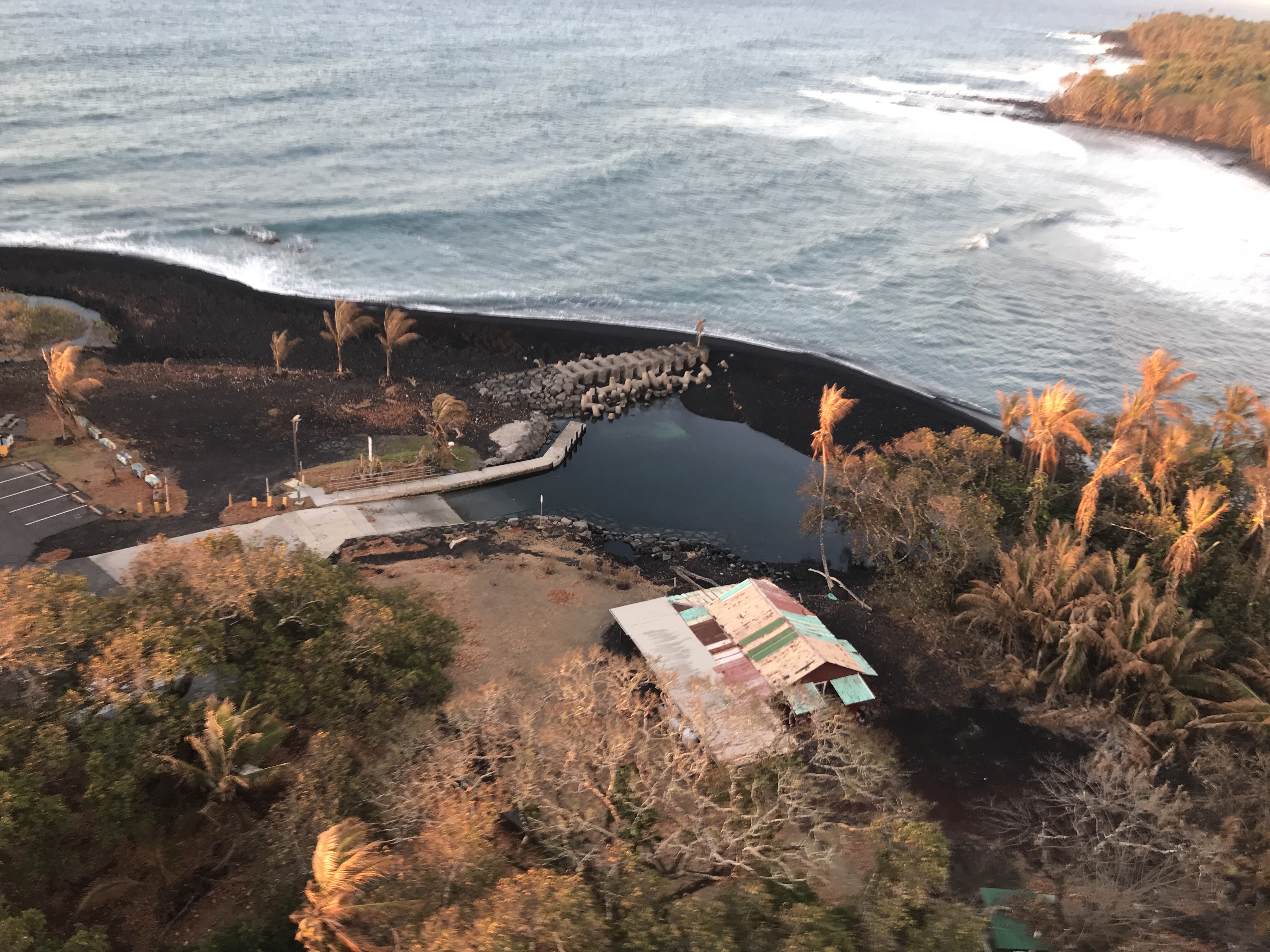
See also morning and evening overflight views today of delta and new shoreline posted by photographer Scott Wilson on Facebook.
From Local News Media
Hurricane Hector didn’t do much more than cause minor discombobulation, as far as I can tell: there were news articles about what it might do, but not much news when it actually passed. Local elections last week were the main news. But the volcano is still news even when it’s relatively quiet:
- HSA: “Eruptive activity remains low at Kilauea summit and East Rift Zone”
- HNN: “Kilauea sulfur dioxide emissions hit lowest levels since 2008“
- HTH: “Pohoiki boat ramp ‘totally blocked by sandbar'”
- BIVN (Aug 7): “Eruption Lull Discussed by USGS Hawaiian Volcano Observatory”
- HTH: “Keauhou Ranch fire now 80 percent contained, officials say”
- BIVN: “Mauna Loa Brush Fire 80 Percent Contained” That’s from today (August 13). See also Aug. 9 article on beginning of fire.
- HNN: “Lava ponds observed in the fissure no. 8 cinder cone”
- BIVN: “Major Hurricane Hector Passes Hawaii To The South“
- BIVN: (Video & article): “Eruption Lull Discussed By USGS Hawaiian Volano Observatory” audio from Aug 6 media briefing
- HNN: “Officials still don’t know when damaged Hawaii Volcanoes National Park may reopen”
- BIN: “Community Meetings on Future of HVNP”
- BIVN (Video and article): “Fissure 8 Naming Process Supported In Council Testimony”
- HSA: “Big Isle must face economic threats”
- BIVN (Video and article): “Puna Residents Impacted By Eruption Deliver Emotional Testimony“
- HNN: “Big Island plans to request $550M for disaster recovery“
- HSA (editorial related to previous headline): “Political snits snarl recovery from Big Isle eruption disaster”
- HTH: “Bad blood in Puna: Ousted councilwoman cries foul” I include this because the eruption influenced Puna’s local election. See also another side of the story:
- HCB: “Newly Elected Council Members Face A County In Turmoil”
- BIVN (Video & article dated Aug. 8): “VIDEO: Special Session Ask For Eruption Relief Discussed At Council”
- HSA: “SBA has approved $25M in Kilauea disaster-related loans”
- HNN: “A charter school whose campus was lost to lava starts a new school year”
- HSA: “Big Island jewelry artist finds new start after Kilauea eruption“
- HSA: “Volcano House reservation doesn’t mean hotel is open”
- KITV: “Bike Volcano: one business still in high demand despite lava flow”
- HPR: “App Connects People With Housing During Emergencies“
- HSA: [Newspaper subscribers only]: “Teachers, students face a new normal in lava-ravaged areas”
#LeilaniEstatesEruption #KilaueaVolcano LATEST: Amazing footage taken by #AndrewDunn of @HawaiiLava captures #Pohoiki boat ramp & Isaac Hale Beach Park still standing with incredible new coastline features; USGS UPDATE👉🏽 https://t.co/zhiiujuJco @HawaiiNewsNow #HINews pic.twitter.com/uVipb3eMKH
— Mileka Lincoln (@MilekaLincoln) August 14, 2018
- Not-so-local-Mashable posted a good article on how Fissure 8 will be named, giving an account of how Puʻu ʻŌʻō was named (which was somewhat controversial, so it’s be done differently this time).
- Dispatches from Volcano posted a nice annotated aerial photo of Kilauea’s new summit (with wildfire going in the background), a few observations on seismicity and fresh views into Fissure 8 on Thursday, and photos from various webcams on Friday (Aug 10). Also, reminding us that this eruption is not over, he linked to the USGS/HVO wrap-up report on the 1955 Kapoho Eruption, from which we may be able to draw some lessons (including the “pauses”.
USGS Social Media Q&A
Old film reels capture 1955 Kīlauea Volcano #LERZ eruption. See lava fountains, spatter cones, steaming cracks, ocean entry – a historical perspective on this active volcano. https://t.co/CfMaxhoYAX
— USGS Volcanoes🌋 (@USGSVolcanoes) August 10, 2018
Q: [How thick is the ash deposited by this eruption around Halemaʻumaʻu Crater?]
USGS: It’s a maximum of 5.5 cm (~2.2 in) near the crater, and thins as you move toward the edges of the ashy area.
Q: [What is now considered Halema’uma’u?]
USGS: It’s the entire depression within the caldera. Halema’uma’u has changed size in the past as well, but it’s still kept the same name. It would be too complicated to start referring to all the past crater outlines by separate names, especially since they’ve been covered up by lava!
Q: [Could larger crater result in larger lava lake, leading to larger eruptions?]
USGS: There could be a larger lava lake, yes. However, the size of the lake doesn’t necessarily control the size or duration of the eruptions in the Rift Zone. The lava lake is just the very tip of the conduit – there’s much more magma in Kilauea’s shallow storage.
Q: Is it true that most of the gas emissions are water vapor?
USGS: “Yes. It’s somewhere in the realm of 2/3 or more of the gas emitted from volcanoes.”
USGS: “Out of the top four [gas emissions] (water vapor, carbon dioxide, hydrogen sulfide, and sulfur dioxide), only hydrogen sulfide is flammable.”
Q: [Any idea what caused temporary SO2 emissions increase at Pu’u O’o last week?]
USGS: We’ve been thinking a lot about that and it could simply be that the system backed up a little bit as the eruption began waning in the LERZ. No firm conclusions have been made yet.
[Question on FB about gas emission levels.]
USGS: SO2 emissions from the summit, Pu῾u ῾Ō῾ō , and the Lower East Rift Zone are all at low levels. LERZ emissions on August 5-6 were ~ 200 tons/day; Pu῾u ῾Ō῾ō emissions on August 6-7 were 200-300 tons/day, and Summit emissions when last measured on July 19 were around 100 tons/day. This SO2 release represents the lowest SO2 emitted from Kīlauea for over a decade.
[Anxious comments on FB by resident asking for more frequent monitoring of gas emissions at summit, which now have to be done by drone and are very sensitive to wind conditions.]
USGS: We understand your concern. The overall output of SO2 from the volcano is very low. SO2 is released from magma when it is very close to or erupting from the ground surface, this is why current emissions are so low. There is no magma near the surface at the summit right now. So even though we’ve not been able to get instruments out to measure since July 19, there would be other signs of magma movement to the surface like earthquakes and ground deformation. (Mia Henry – yes, the emissions do indicate change) We are cross correlating many data streams and will get more gas measurements as soon as winds permit. We remain very committed to ensuring people are made aware of volcanic hazards.
[More anxious comments, concerns about debris choking vent and explosive eruptions.]
USGS: We did see emissions at Pu’u ‘O’o start up again after several months of very little activity, but the levels (200-300 tons/day) are still quite low. Overall, emissions at the volcano as a whole are the lowest they have been in a decade. While this might imply that magma is being prevented from degassing freely, it may also reflect a decrease in magma supply to the system. That’s why we combine our gas monitoring with the seismic and deformation measurements, so we’re not relying on any one indicator. At the moment, all is quiet, but we’re keeping a close eye on things just the same!
[Same person again asks for more frequent SO2 readings.]
USGS: It’s absolutely beneficial to monitor gas levels as often as possible, but it’s not our only indicator of renewed activity. We are also carefully watching the seismicity (which would indicate magma movement) as well as deformation (which would indicate an influx of new magma). At the moment, our ground crews in Puna (who wear gas badges) have detected very little sulfur dioxide anywhere in the fissured area.
Sulfur does indeed leave yellow deposits, but in this eruption it’s been more commonly observed in spots where the gases are decreasing in temperature. That allows the native sulfur to sublimate on the surrounding rocks rather than escape directly to the atmosphere as sulfur gas.
Q: [Why have SO2 levels dropped in LERZ?]
USGS: Magma needs to be very near the surface in order to outgass SO2. There’s just not much near the ground in the LERZ anymore that has a lot of SO2 left in it.
Q: [Television newscast claimed Highway 11 had dropped 3 feet. Subsidence?]
USGS: There has been some subsidence, but it’s because the earthquakes at the summit caused the fill beneath the road to settle (and in a couple of cases fall into old lava tubes). It’s an engineering issue rather than significant fault movement.
Q: [Request for more photos of damage to HVO building.]
USGS: We’re limiting the number of staff who are allowed to visit HVO, and their mission in the past weeks has been to move as much equipment and gear out of the observatory as possible. It’s been rough for HVO’s scientists who have had to leave their professional home, and we prefer not to spend a lot of time showing off the damage to the building.
It probably wouldn't. Here's a discussion of the topic from 2014: https://t.co/HTl5n84cGF
— USGS Volcanoes🌋 (@USGSVolcanoes) August 8, 2018
[Q: Someone on FB asked whether anything bad happened with Hurricane Hector making landfall near Kilauea.]
USGS: The hurricane passed south of the island without making landfall, and there were no serious weather effects. Our field crews reported the expected rain and wind before they paused operations on Wednesday.
Q: [Why are you causing this a “pause”?]
USGS: “Because fissure eruptions in this area have paused in the past (see the 1955 eruption, which had 5 and 16 day pauses: https://volcanoes.usgs.gov/volcanoes/kilauea/geo_hist_1955.html … ). Unless time elapsed and monitoring evidence lead us to believe it’s more than that, we consider this a pause.”
Q: [So are you basing “pause” assessment on current data or past eruptions?]
USGS: We generally don’t comment on data that’s still being reviewed. At the moment, we’re treating this as a pause for safety’s sake – given how fast fissures opened and inundated properties at the beginning of the eruption, we don’t want to give the all-clear too early.
Q: [How do you know when eruption is really over?]
USGS: In 1955, two pauses of 5 and 16 days occurred during that 88-day-long LERZ eruption. This could be a pause, or, it’s also possible that the slowdown reflects the end of the eruption. It’ll take days, possibly weeks, to determine with certainty.
[Same question asked a few days earlier]
USGS: Because past eruptions have had pauses, we would want to see a pretty long period where there was no significant seismicity at the summit or in the LERZ, no more deformation indicating magma movement, less SO2 output, and no more collapse or explosive summit activity.
Q: [Fissure 8 stopped because collapses stopped, or the other way around?]
USGS: That’s a question we’re still working out. The collapse was driving pulses of magma downrift, but it was ultimately a response to the draining of magma from the summit (not the other way around).
Q: [Why do eruptions slow, pause, pick back up?]
USGS: In some cases, it’s due to magma supply at the eruption site. For example, the summit didn’t necessarily drain everything all the way down the East Rift Zone all at once, which could mean that some magma is still moving through the system and has yet to erupt.
USGS: Blockages in the system could also cause a pause, like clogging a pipe. Unfortunately, we can’t see underground, so we don’t know if it’s either of those things – or neither.
Q: [How can you tell there’s magma at summit when it’s not visible?]
USGS: We use three main monitoring sources: gas type (more SO2), earthquake locations (magma cracks rock when it moves through a volcano), and deformation (the summit changes shape when magma inflates it).
Q: [If pause is due to blockage, would seismicity increase?]
USGS: Blockages would probably show up more in deformation than they would in seismicity. Much of the seismicity in the lower East Rift Zone was due to migrating lava cracking rock as it opened pathways for flow; once flow paths were established, seismicity decreased.
Q: [Presumably there are tiltmeters in LERZ; why isn’t data available on website?]
USGS: Actually, we don’t have any tiltmeters in the lower East Rift Zone. Prior to the eruption, what few tiltmeters we had were vandalized, and since installation of tiltmeters is not an easy task, we were not able to install any around the eruption site. Instead, we monitor the lower East Rift Zone with a combination of GPS (available on the monitoring site) and satellite radar. Neither dataset shows any inflation in the area of the fissure system.
[Q: Is lava pond in F8 below original ground level?]
USGS: The lava pond may be at a depth near the pre-eruption ground surface – we are working on some models this weekend.
[Q: What’s the red in F8 cone?]
USGS: The UAS Team also did a thermal overflight and some of the “red” is residual heat from the hot magma fountains.
Q: [What’s left where the inactive fissures are?]
USGS: There are cracks, holes, small lava cones, and in some places sulfur deposits. The fissures themselves usually have some kind of pile-up of lava around them.
Q: [How much more will lava encroach on Isaac Hale Park / Pohoiki boat ramp? ]
USGS: That’s a question of lava supply to the flow front, and how long it lasts now that fissure 8 is inactive – or, if other fissures reactivate. Beyond that, we really can’t say.
Q: [All that lava entering ocean now is just residual from before F8 shut off supply to channel a week ago?]
USGS: Yes. There really has been a lot. Think about how long the entry at Kapoho was active even after lava channel moving to the north around Kapoho Crater was diverted to the west side of the crater.
Q: [Which way does sand move on Big Island?]
USGS: The trade winds and longshore current are currently pushing the sand and rock fragments slowly toward the southwest.
That's within the possible behavior of a fissure, yes, but it could also just resume the activity we've seen in previous weeks (lava flowing into a channel).
— USGS Volcanoes🌋 (@USGSVolcanoes) August 13, 2018
Followup Q: [For years?]
USGS: “Potentially – Pu’u ‘O’o, for example, erupted for years before the current period of activity. However, this could also be similar to previous fissure eruptions, which ended after several months.”
[I’m pleased to see the recent XKCD cartoon making the rounds get an honorable mention]
Absolutely we did. It's pretty accurate!
— USGS Volcanoes🌋 (@USGSVolcanoes) August 7, 2018
Rumor Whack-a-Mole
[Comment by someone on HVO’s FB page confidently predicting lava will erupt “above Hwy 130” at the next full moon, never mind the eruption’s been going over 3 months, and predicts “an explosive eruption closer to the coast.” I include this only because USGS quashes the moonphase fallacy.]
USGS: While tides may have a very minor effect on seismicity, the phases of the moon are a purely visual phenomenon and have zero influence on eruptions. There is currently no sign of significant inflation or deflation in any part of Kilauea’s plumbing system, and we do not expect to see any explosive activity on the rift. Fissures, while they can fountain, are not explosive, and the explosions that have occurred at the coastline are due to the interaction of very hot lava with cold seawater.
A FEw More Photos from Social Media
Andrew Richard Hara posted ten outstanding overflight photos of the LERZ on a clear day (August 9), but you’ll have to follow the link to Instagram and hover your cursor over the first photo to go forward/back and see the rest:
Sadly, the third photo in that batch clearly shows the footprint of John & David’s burned house (the lava rooster house) next to the cell tower.
Now, some video clips from the past week taken down at the coast: