August 2, 2018. USGS: “During this morning’s overflight, HVO geologists used a telephoto lens to capture this image of the fissure 8 cone. Activity within the vent was low, with small bubble bursts in the eastern part of the vent and low lava fountains on the western side. The fountains occasionally threw spatter onto the west rim of the cone (right).” (Full-sized)
Today’s summit collapse came at 11:55 am HST, energy equivalent of an M 5.4. Once again there was a cluster of high M3 foreshocks in the ten minutes or so beforehand, so that there was already some suspended dust from rockfalls.
Northeast Rim livestream cam was stuttering today, but still dramatic.
Also note that HVO’s Fissure 8 webcam was damaged by a brushfire Tuesday and ceased working. In fact, right now it’s stuck on the last photo it took.
While checking on the main webcams page, I caught a lovely time of the evening up at the summit. From the ones that are working:
Former Overlook Vent cam, now pointed at a sheer cliff above where it used to be. (Full-sized)HVO Panorama cam. All of these from about 6:40 pm HST. (Full-sized)Halema’uma’u wide angle webcam. (Full-sized)
And speaking of photos, I took a night off, and come back to find HVO posted a ton of good photos! Which I shall mirror here so they’re easier to find after they’ve “fallen off” that Photo & Chronology page.
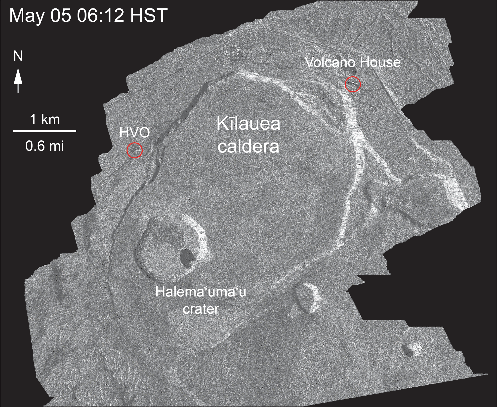
Most importantly, a new frame from the Cosmo-Skymed satellite radar animation:
Aug 1, 2018. USGS: “This animated GIF shows a sequence of radar amplitude images that were acquired by the Agenzia Spaziale Italiana CosmoSkyMed satellite system. The images illustrate changes to the caldera area of Kīlauea Volcano that occurred between May 5 and August 1 at about 6:00 a.m. HST.” (Full-sized
Accompanying text with this animation: “Over time, expansion of the summit eruptive vent within Halema‘uma‘u crater and the widening of Halema‘uma‘u itself are obvious. Starting in late May, the development of several cracks outside Halema‘uma‘u is clear, and inward slumping of a large portion of the western, southwestern, and northern crater rim begins. Much of this motion appears to be coincident with the small explosions from the summit that have taken place on a near daily basis since early June. The most recent radar scene, from August 1, shows continued motion along cracks over a broader area of the caldera floor, extending east of Halema‘uma‘u. We expect this slumping to continue as long as the collapse events and overall subsidence persist.”
More Kilauea Summit Photos Aug 1-2
I think HVO/Jaggar Museum are visible on the right caldera rim if you zoom in; this must’ve been taken from the Volcano House overlook.
August 1, 2018. USGS: “A panoramic view of Kīlauea’s summit, with remobilized ash (blown by wind) in the sky above Halema‘uma‘u.” (Full-sized)August 1, 2018. USGS: “Closer view of the dust cloud above Halema‘uma‘u, created by wind stirring up ash deposits on the south side of the crater.” (Full-sized)
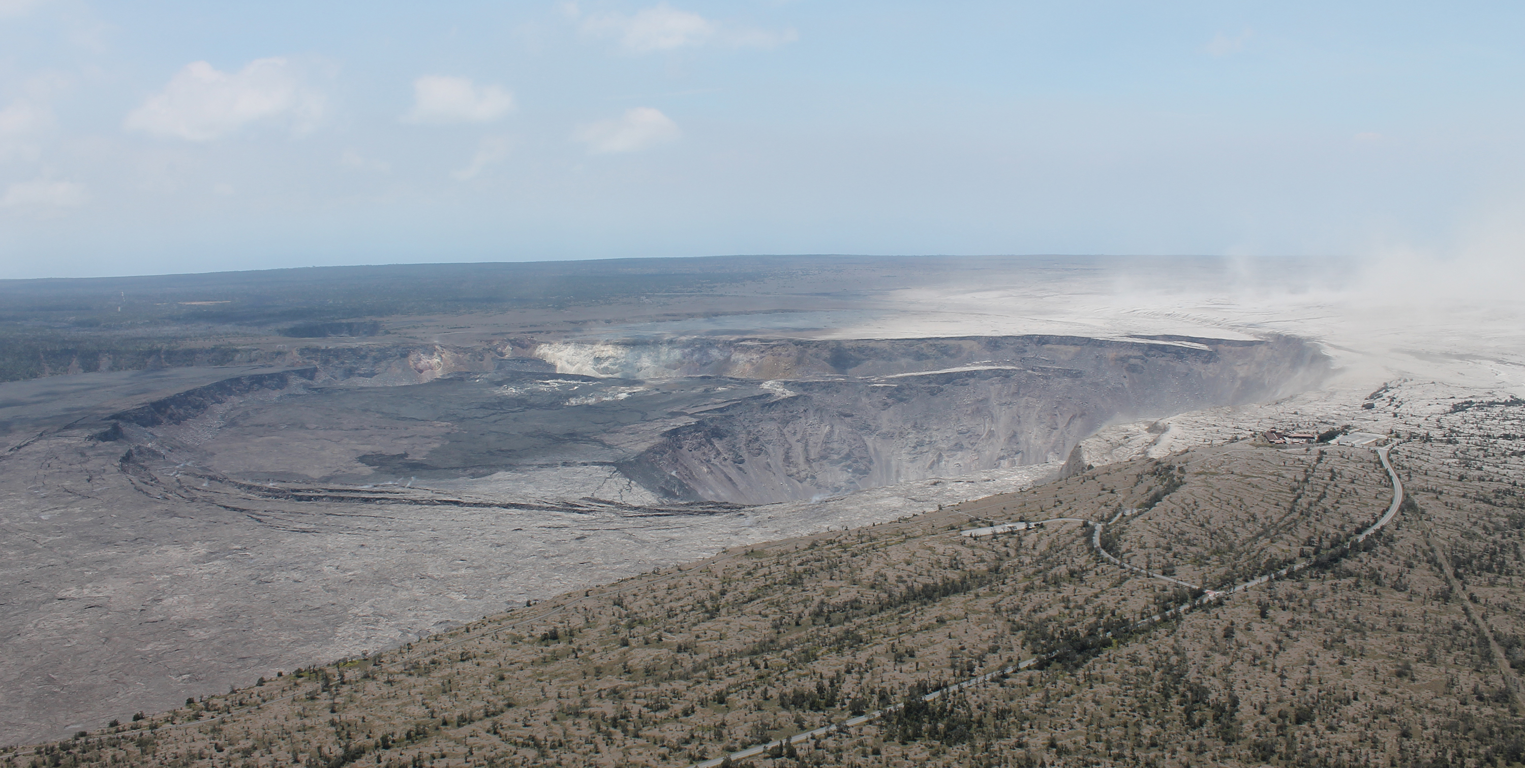
Beauty shot of the newly-remodeled caldera.
USGS: “An aerial view of Kīlauea Volcano’s summit taken on August 1. A section of Hawai‘i Volcanoes National Park’s Crater Rim Drive and the road leading to the Kīlauea Overlook parking area are visible at lower right. HVO, Jaggar Museum, and the museum parking area are visible at far middle right. A down-dropped section of the caldera floor can be seen to the left of Halema‘uma‘u, a crater that continues to grow. On the caldera rim (upper right) light-colored ash deposits from explosions in May are stirred up by brisk winds, creating a dust cloud that’s blown downwind.” (Full-sized)USGS: “Then and now. It has proven difficult to exactly match past and present views of Kīlauea’S summit to show the dramatic changes in the volcanic landscape, but here’s our latest attempt. At left is a photo taken on November 28, 2008, with a distinct gas plume rising from the vent that had opened within Halema‘uma‘u about eight months earlier. At right is a photo taken on August 1, 2018, to approximate the 2008 view for comparison.” (Full-sized)
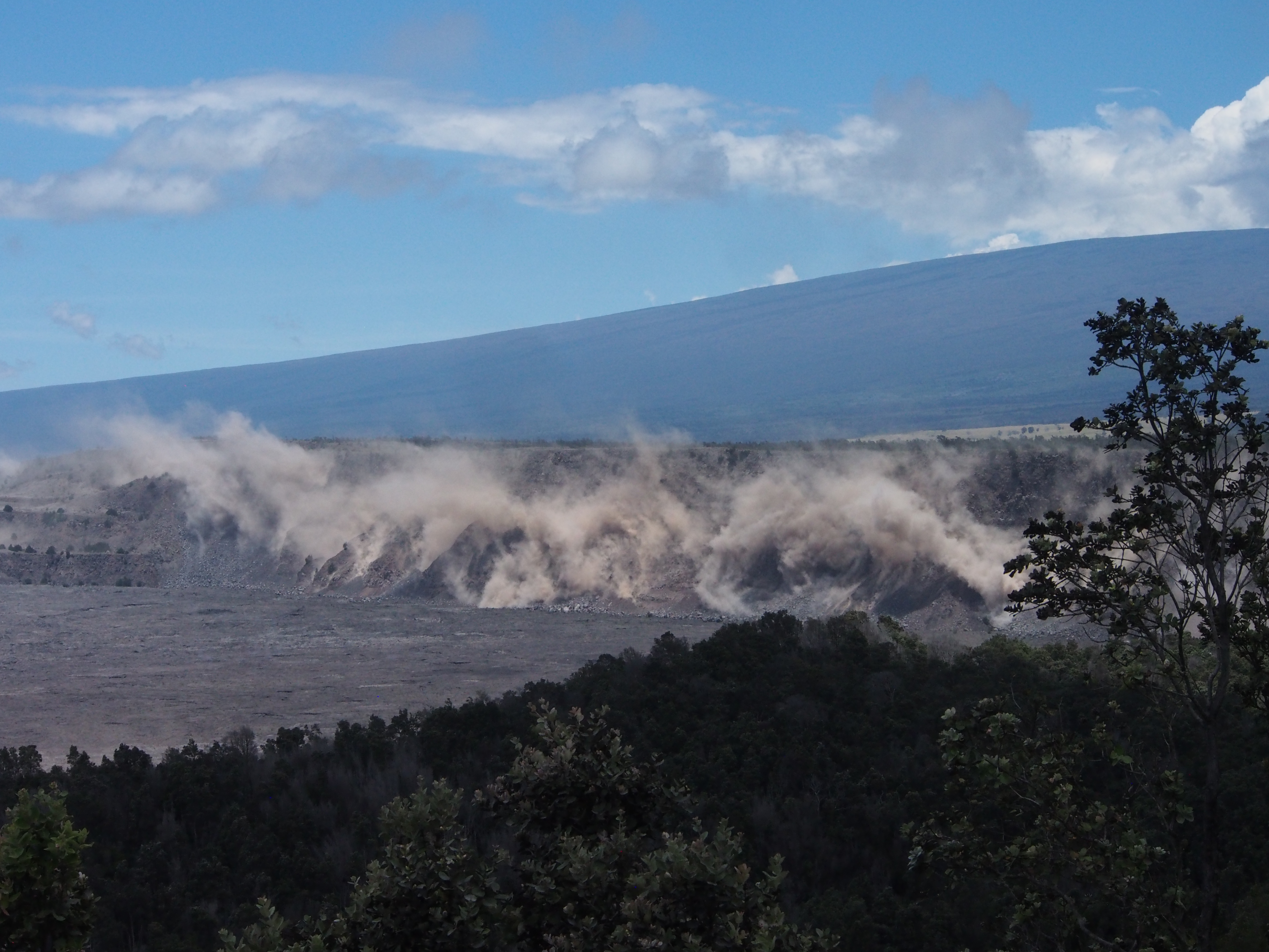
And another view of today’s summit collapse.
August 2, 2018. USGS: “Rockfalls along Kīlauea’s caldera walls are common during summit collapse events. This image, taken just after today’s 11:55 a.m. HST collapse, shows dust rising from rockfalls along Uēkahuna Bluff.” (Full-sized)
Meanwhile, down in the LERZ…
Fissure 8 / Lava Photos Aug 1-2
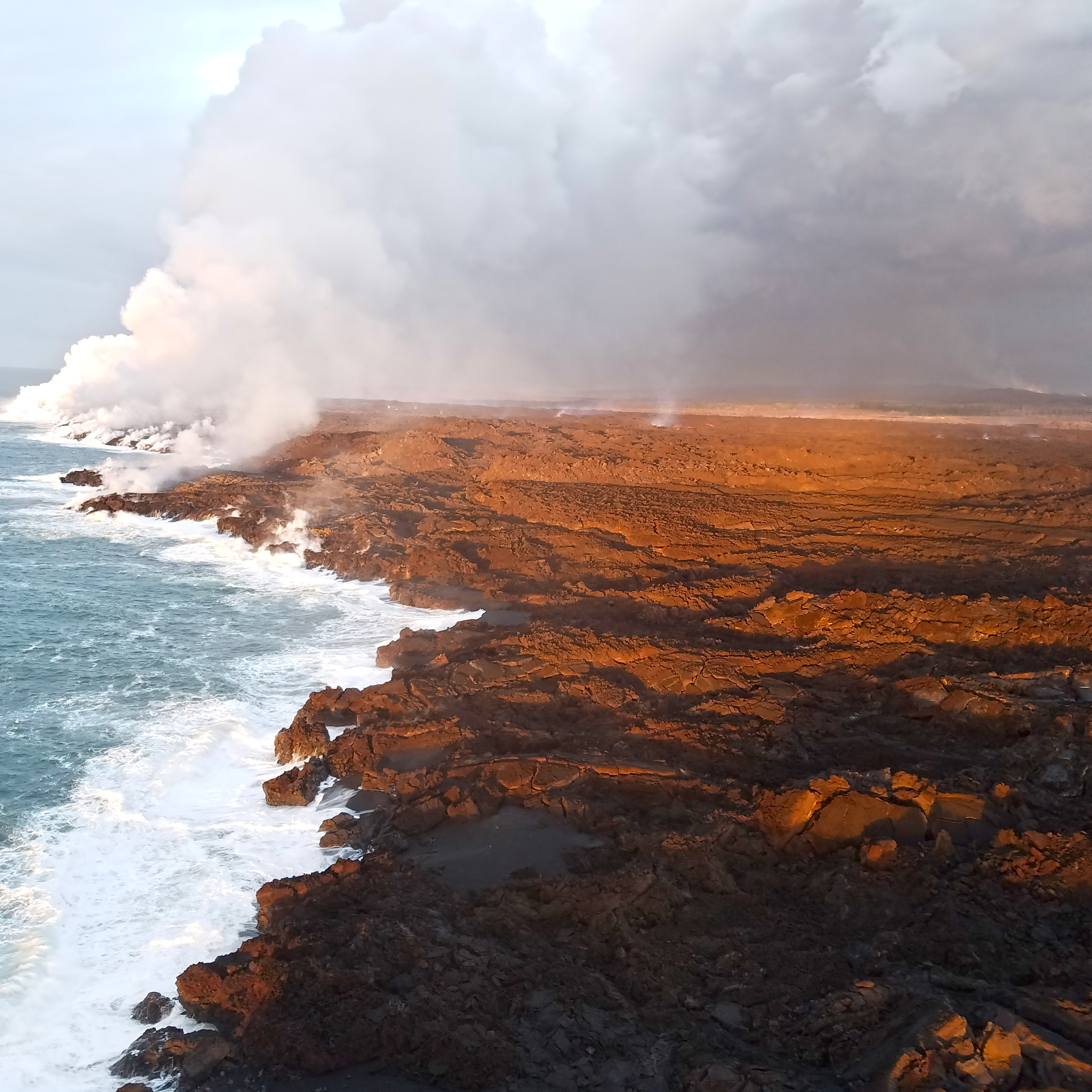
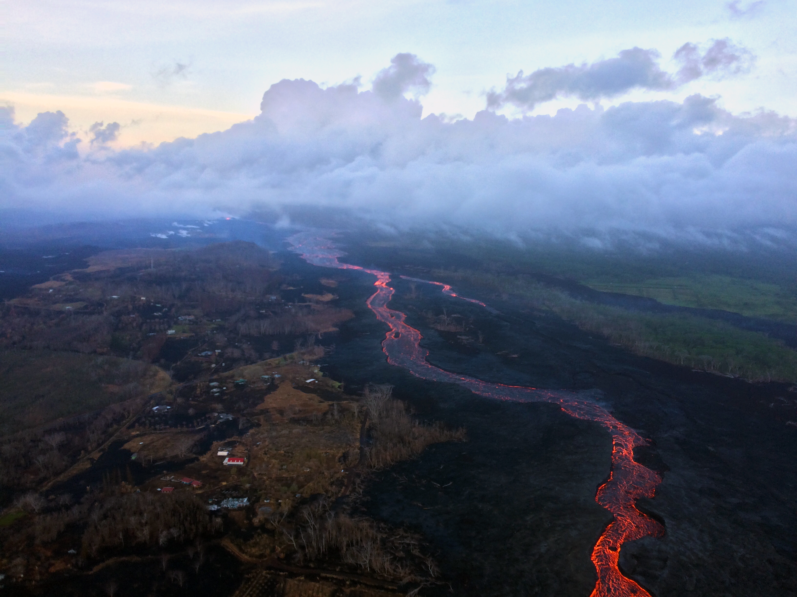
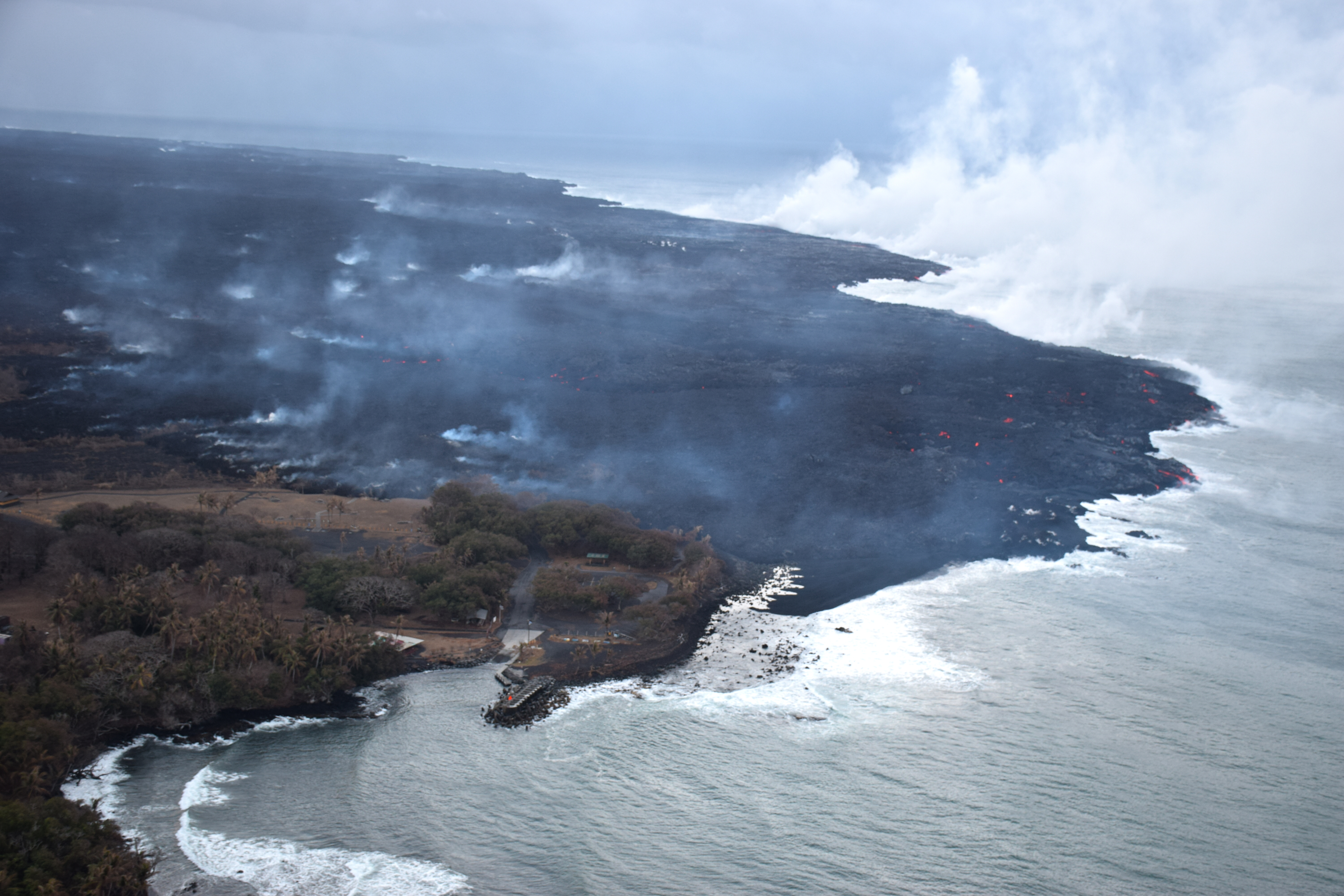
August 1, 2018. USGS: “Aerial view toward the southeast of the fissure 8 lava channel. Overflows have formed a pool of lava at the channel bend just west of Kapoho Crater (vegetated cone at left).” (Full-sized)August 1, 2018. USGS: “Early morning aerial view toward the southwest of the ‘a‘ā flows along the coast. Plumes of laze along the broad ocean entry flow front are near the former Ahalanui Beach Park.” (Full-sized)August 1, 2018. USGS: “Aerial views of Isaac Hale Beach Park. The westernmost ocean entry is overriding lava flows that entered the area last week.” (Full-sized)
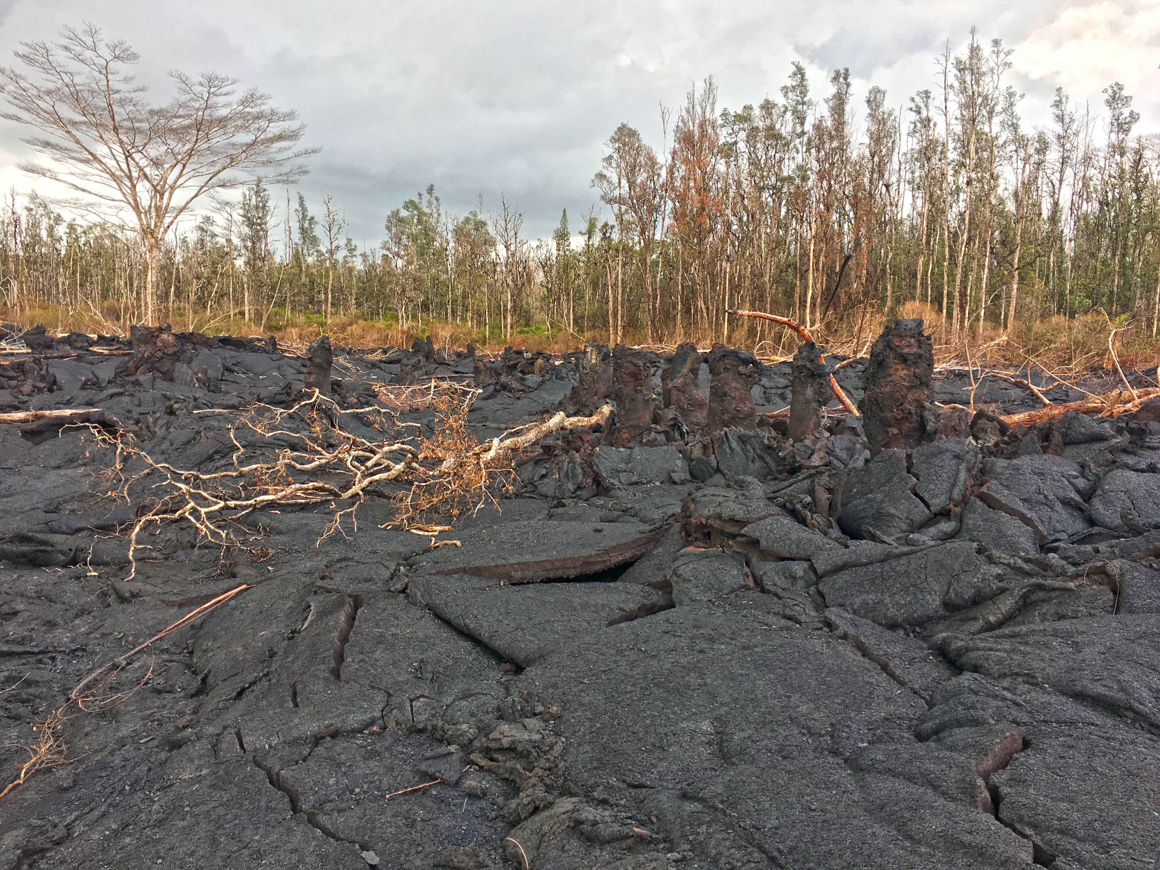
New Lava Tree Park?
August 1, 2018. USGS: “Lava trees, shown here in a fissure 8 flow, are formed when lava inundates a forested area and surrounds the tree trunks. Lava cools against the trunk, forming a column of rock and eventually burning the tree. As the lava flow deflates, the rock surrounding the trunk is left standing above the flow surface, forming a “lava tree” and showing the high-stand of lava that flowed through the area.” (Full-sized)August 2, 2018. USGS: ” An early morning aerial view (looking west) of the fissure 8 lava channel. Downstream of the vent, the channel splits to form a “braided” section in the lava channel, and, this morning, the north (right) arm of the braided section appeared to be partially abandoned. Lava was still visible in part of the northern braid, but the lower section was only weakly incandescent. During today’s overflight, lava within the channel generally appeared to be at a lower level than in previous days.” (Full-sized)
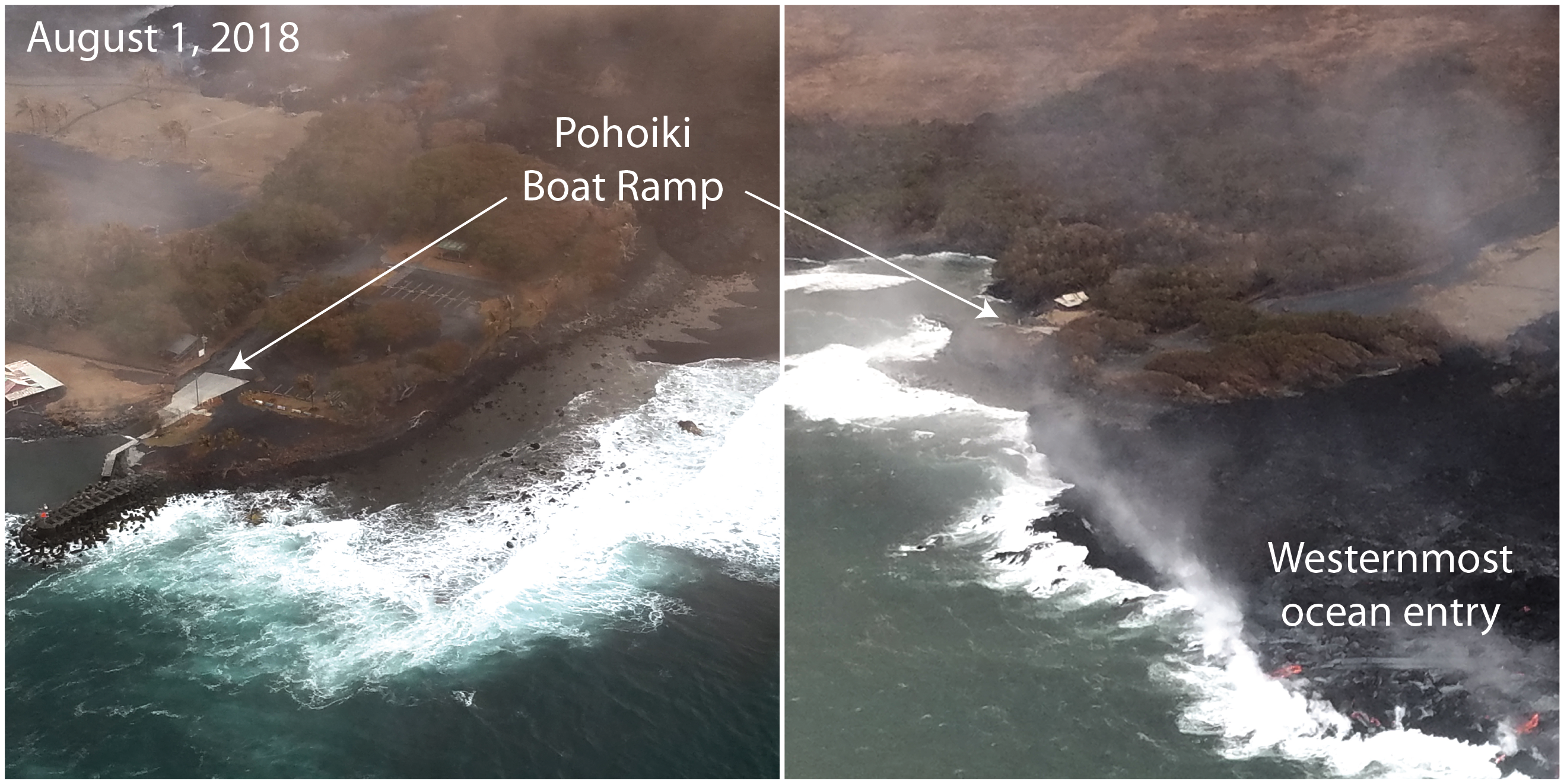
Zooming in on full photo, you can see bits of red lava peeping out behind Isaac Hale Park.
August 2, 2018. USGS: ” During this morning’s overflight, the ocean entry laze plume was being blown offshore, allowing this fairly clear view (looking northeast) of the Pohoiki boat ramp at Isaac Hale Beach Park. Incandescent (glowing red) spots of lava can be seen within the flow field beyond the boat ramp. HVO geologists also observed a few oozes of lava on or near the western flow margin, but all appeared weak as of 6:00 a.m.” (Full-sized)
Update on tiny no-longer-an-island, and a new vocabulary word:
August 2, 2018. USGS: ” On July 13, we posted an image of a tiny “island” forming just offshore of the Kapoho ocean entry. Today, that feature—likely a submarine tumulus of lava that built up underwater and emerged above sea level—is no longer an “island.” It now looks more like a peninsula, attached to the coast by a black sand tombolo, a sandy isthmus, creating a feature known as a “tied island.” Whether or not it will withstand wave erosion over time remains to be seen.” (Full-sized)
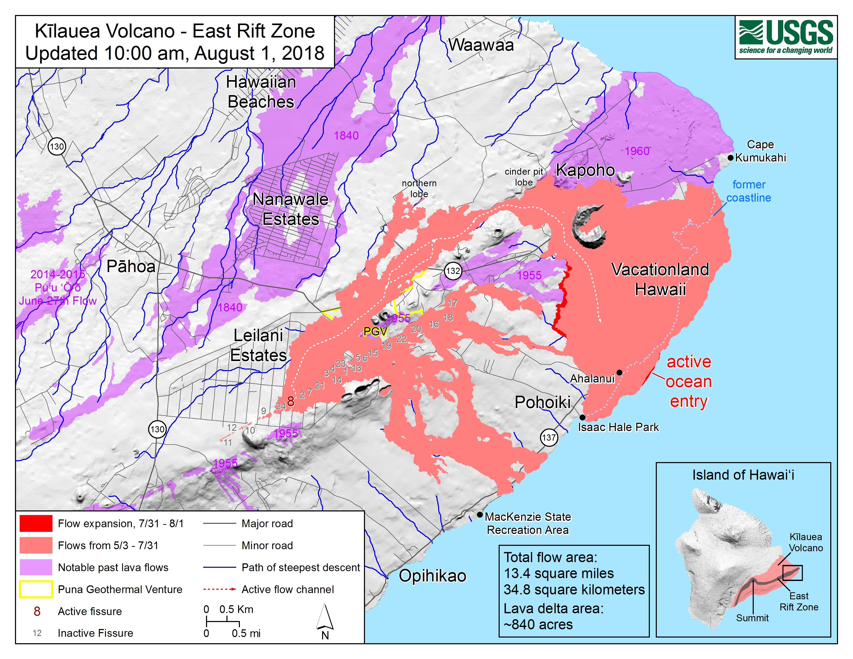
August 1, 2018. USGS Map of LERZ as of 10 am. (Full-sized)
I’m going to do a full scour of news websites and social media this weekend, but I note that with the new format at the Tuesday evening Pahoa community meetings, there was no Steve Brantley USGS slideshow.
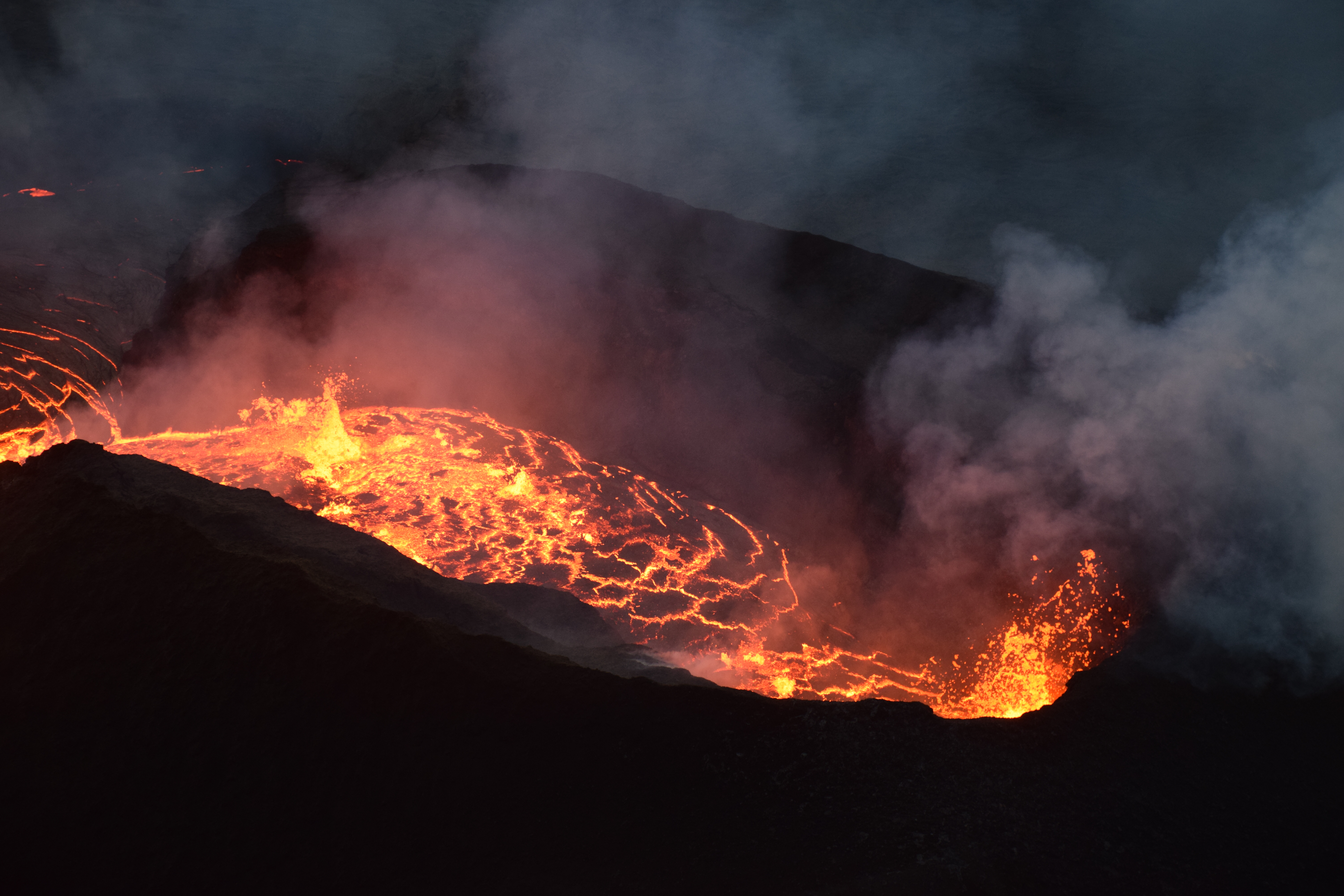
Thursday, Aug 2, 2018, 6:00 am – Kilauea's lower east rift zone overflight: A view of the activity closest to Pohoiki. Note the flow on top of the original ‘a‘a, building up its height even more.
Thursday, Aug 2, 2018, 6:00 am – Kilauea's lower east rift zone overflight: Fissure 8 feeds lava into the perched channel, while the other inactive fissures vent gases.