Today’s entry is going to be a challenge, because my computer chose a holiday to go pau. Arthritis and dodgy vision versus voice dictation and tablet — who will win?

Today’s eruption summary
The LERZ eruption continues pretty much as usual, with a few minor embellishments to keep field crews on their toes.
Today’s HVO update noted that Fissure 8 “has been pulsing with more vigorous output in 1-3 minute bursts.” When asked for clarification, USGSVolcanoes replied, “No true indication of change.” F8 continues to send lava downriver to Kapoho, where lava is oozing out along most of the broad front and encroaching on Kapoho Ag and Beach Lots properties.
Fissure 22 continues to spatter intermittently and produce a short, sluggish flow:
Wednesday, July 4, 2018, 5:45 am – Kilauea's east rift zone overflight: Fissure 22 continues to spatter bits of lava…
Posted by Extreme Exposure Fine Art Gallery on Wednesday, July 4, 2018
…and it still looks like a kid’s science experiment. (It’s hard to tell from overhead, but it’s a perfect steep-sided cone.)
Remember how the lava channel clogged up temporarily around the bend at Kapoho Crater yesterday? It’s still having problems:

I lucked out this morning and caught @HotSeatHawaii ‘s sunrise overflight live, which offered a good view this. Part of the lava is going wide instead of making the sharp turn, though it joins back up around the bend. (More photos below.)
Today’s summit collapse/explosion occurred at 10:19 AM HST. The view was fairly clear today, and the rockfalls were spectacular:
USGS Update With Steve Brantley
Steve Brantley’s Tuesday evening slideshow at Pahoa Community Meeting:
My transcript posted here.
More USGS Photos
The USGS tweeted these fireworks to celebrate the Fourth of July:


But while celebrating a holiday, we shouldn’t forget those who can’t celebrate in their own back yards right now:

Last but not least, Halema‘uma‘u is beginning to establish a sort of Grand Canyon rugged beauty.

Today’s Kīlauea collapse/explosion before & after:
Here's a casual view into #kilauea 'daily drop' on July 4. (Made using HVO KECam snapshots.) pic.twitter.com/m0qdzyZXpt
— Turo Lindqvist (@turolle) July 4, 2018
From Other Agencies
Aloha, Adam! Our recent eruptions at the Kilauea summit have not had lava associated with them- only gases, ash, and other volcanic particles. Our radar can detect the ash plume generated by these eruptions. These radar images are from an eruption on 6/1/18. #KilaueaVolcano #hiwx pic.twitter.com/WRKPxek8fG
— NWSHonolulu (@NWSHonolulu) July 4, 2018
Image processing to make certain IR and visual data stand out:
Update: Eruption from #KilaueaVolcano observed by the latest #Sentinel2 imagery on 2 July 2018
– SWIR image shows a distinct pyrocumulonimbus cloud that looks like with the SO2/HCl/H2O plume from the lower east rift zone according to @theWeatherboy @bodyboarder22 pic.twitter.com/Ndg5HKM36e
— BigData Earth (@BigDataEarth) July 3, 2018
From Local News Outlets
- HSA: “Homeowners whose properties are undamaged by lava but off-limits continue to live without closure”
- HSA: “Lava-Related restrictions lifted for suffering Kalapana“
- HTH: “ Lava-fueled storm produced more than 1,000 lightning strikes“
- HTH: “Lava task force pau; more homes lost“
- HNN: “Lower Puna resident: “Are we safe?” Looting remains concern
- BIVN: “VIDEO: Residents Question Civil Defense At Public Meeting“
- BIVN: “VIDEO: Highway 130 Reopening Discussed By Officials“
- An “exploquake” report and a few fresh photos from: “Dispatches from Volcano“
USGS on Social Media
#HappyFourthOfJuly to you all! Thank you for following so closely, asking great questions, and being curious about #science! #Kilauea #Fissure8 overnight put on a show for drone footage and #geologist observers. #KilaueaEruption #KilaueaErupts #FourthofJuly #IndependanceDay pic.twitter.com/QzKUvaaPmC
— USGS Volcanoes🌋 (@USGSVolcanoes) July 4, 2018
The amount of people on the planet is growing – more people living in volcanic areas. And because of this, more people are impacted by volcanoes & the information age permits news to travel. So simply, the media coverage – volcanoes are simply in the news more frequently now.
— USGS Volcanoes🌋 (@USGSVolcanoes) July 4, 2018
That area just outside the southeastern edge of the fissure 8 cone has been there for since early June. It seems to be about the same size and is an area where lava pools and then flows into the channel.
— USGS Volcanoes🌋 (@USGSVolcanoes) July 4, 2018
The ocean entry and delta can be a very unstable place. It's not floating, but it can be perched on top of rubble from fragmenting flow edges that can collapse and cause the delta to slump. https://t.co/FvZkPRWhv2
— USGS Volcanoes🌋 (@USGSVolcanoes) July 4, 2018
The delta has had days where no extension has occurred, and days when there's been a lot of extension. We've been working on figuring out how much of it is active on the seafloor, but we don't think the changing flow front activity is a sign of anything slowing down.
— USGS Volcanoes🌋 (@USGSVolcanoes) July 4, 2018
There are pressure waves being released from within the ground just below the ground along the southern crater margin. The pressure waves are distinct and are detected via infrasound.
— USGS Volcanoes🌋 (@USGSVolcanoes) July 5, 2018
USGS Facebook (all comments follow that post):
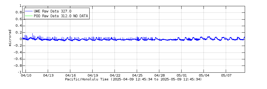
Q: Could you please discuss the changes of the tiltmeter at the summit since July 1st? It looks as if the motion has completely flipped 180 degrees. I heard that the sensor was re-positioned or re-calibrated. Is that true? Maybe it was turned upside-down?🤣 Please help us understand why it looks so different.

[Other FB member says they “changed instruments from an analog tiltmeter to a digital one.”]
USGS: Yes. We switched the tilt data to a different instrument. Thanks Rebecca Zabel Hatch. UWE was flaky and wasn’t really telemetering data consistently, so we switched to the digital UWD. Tilt drifts slowly down in the time between Type A explosive events then rockets back up during the Type A pressure release.
Q: In livestream it looks like white bluff in distance on left reacts first, then crater. Consistent with earthquake map showing the epicenter toward the south. Where are the epicenters of these explosive events, generally?
USGS: They are consistently located along the boundary at the south wall of the crater.
Q: About what duration are these 5+ events?
USGS: Approximately 4 seconds for this one.
In answer to several people asking for pics of F#22…
USGS: This is a photograph from yesterday evening. Fissure 22 is the one fuming and the flow is the darker area to its right. PGV can be seen on the right side.

From Photographers / Social Media
Just a reminder that those cruises to Hawai’i still offer lava viewing, even if the park is off-limits:
Mick Kalber’s overflight vid for this morning isn’t up yet, but here’s some of Brian Omori’s photos
from that same trip:
Wednesday, July 4, 2018, 5:45 am – Kilauea's east rift zone overflight: The textured surface of the channel exiting fissure 8 is mesmerizing, to say the least!
Posted by Extreme Exposure Fine Art Gallery on Wednesday, July 4, 2018
Wednesday, July 4, 2018, 5:45 am – Kilauea's east rift zone overflight: A closeup of the interior of fissure 8's pu‘u, as it discharges lava with vigor.
Posted by Extreme Exposure Fine Art Gallery on Wednesday, July 4, 2018
Wednesday, July 4, 2018, 5:45 am – Kilauea's east rift zone overflight: A leafless, lifeless tree still remains standing near the edge of fissure 8's periphery on Luana St, in Leilani Estates.
Posted by Extreme Exposure Fine Art Gallery on Wednesday, July 4, 2018
Tephra on colored roofs:
Wednesday, July 4, 2018, 5:45 am – Kilauea's east rift zone overflight: Downwind of fissure 8, these homes are covered in a thick layer of tephra, blanketing roofs and property with the cinder-like material.
Posted by Extreme Exposure Fine Art Gallery on Wednesday, July 4, 2018
Here’s the mess that’s piled up at the turn around Kapoho Crater:
Wednesday, July 4, 2018, 5:45 am – Kilauea's east rift zone overflight: A blockage of the channelized flow as it rounds…
Posted by Extreme Exposure Fine Art Gallery on Wednesday, July 4, 2018
Same spot, closeup:
Wednesday, July 4, 2018, 5:45 am – Kilauea's east rift zone overflight: A massive overflow of the channelized flow…
Posted by Extreme Exposure Fine Art Gallery on Wednesday, July 4, 2018
Wednesday, July 4, 2018, 5:45 am – Kilauea's east rift zone overflight: Another view of the overflow of the lava…
Posted by Extreme Exposure Fine Art Gallery on Wednesday, July 4, 2018
Kapoho:
Wednesday, July 4, 2018, 5:45 am – Kilauea's east rift zone overflight: A view looking west at what remains of Kapoho beach and farm lots. 🙁
Posted by Extreme Exposure Fine Art Gallery on Wednesday, July 4, 2018
Fire and water on the 4th:
Wednesday, July 4, 2018, 5:45 am – Kilauea's east rift zone overflight: An approximately 2 mile wide flow front enters the sea at Kapoho, forever altering the coastline and shape of the island.
Posted by Extreme Exposure Fine Art Gallery on Wednesday, July 4, 2018
Of course, some volcano photographers dug out past highlight reels for the 4th.
Unlike any fireworks I’ve ever seen🎇 #LeilaniEstatesEruption #KilaueaVolcano UPDATE: I took this video in #LeilaniEstates on May 6 from Luana St. The heat, the sound, the mana was unlike anything I ever imagined I’d experience in my life; USGS LATEST👉🏽 https://t.co/nIsnKxSww3 pic.twitter.com/A8trzvxY2m
— Mileka Lincoln (@MilekaLincoln) July 4, 2018