Fissure 8 gushes on unchallenged and unchanged, while Fissure 22 — remember the chief subject of Lavacam?— has started spattering 50-80m and sending out a modest lava flow headed NE along the edge of previous flows.
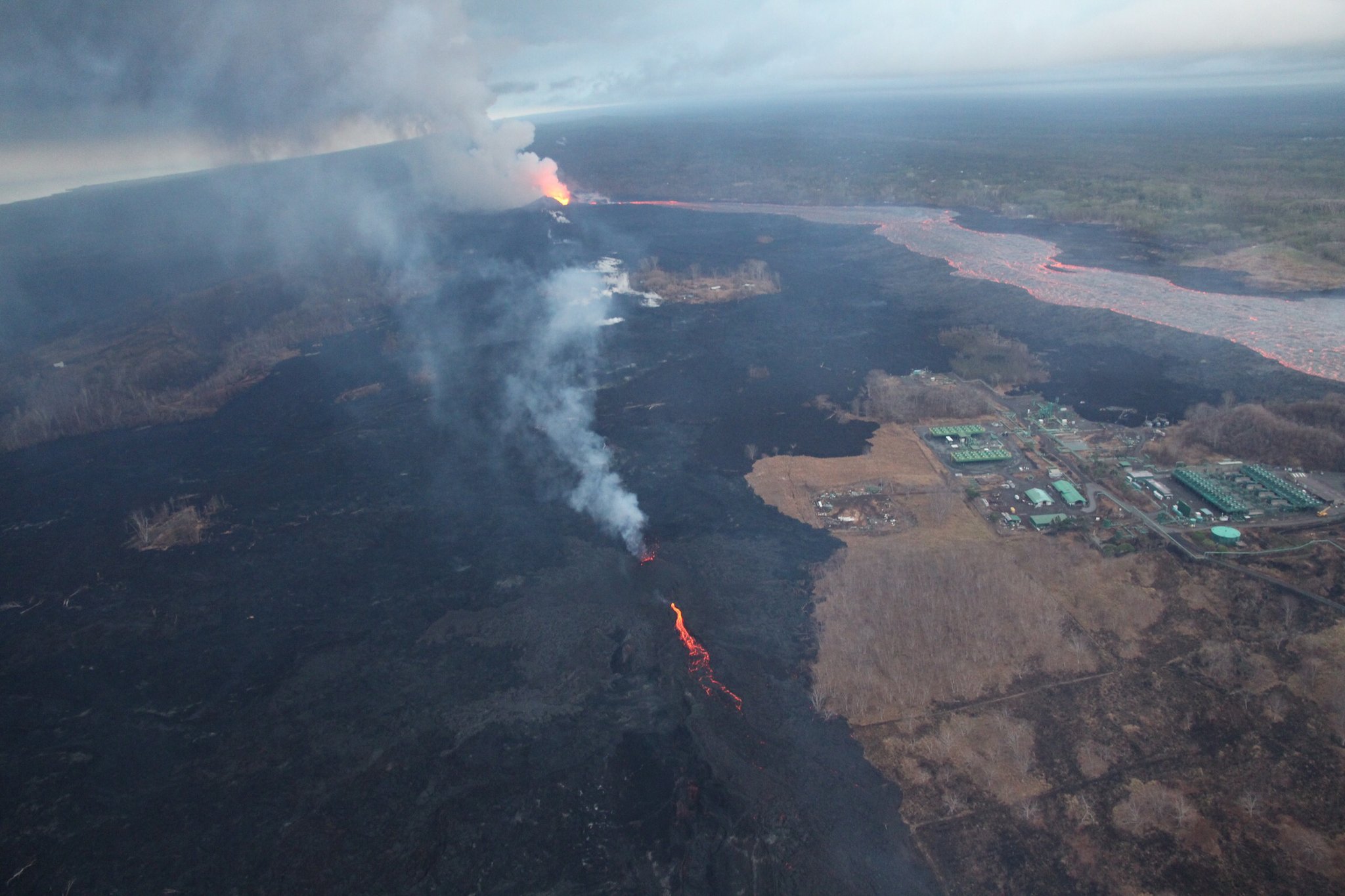
Down at the coast, lava continues to ooze out from under much of the northern part of the delta along a broad front, with “pasty” lava squeezing out in several places along Kapoho Beach Lots.
As of 8:30pm 11pm HST, I’m waiting for confirmation of the next summit collapse/explosion.
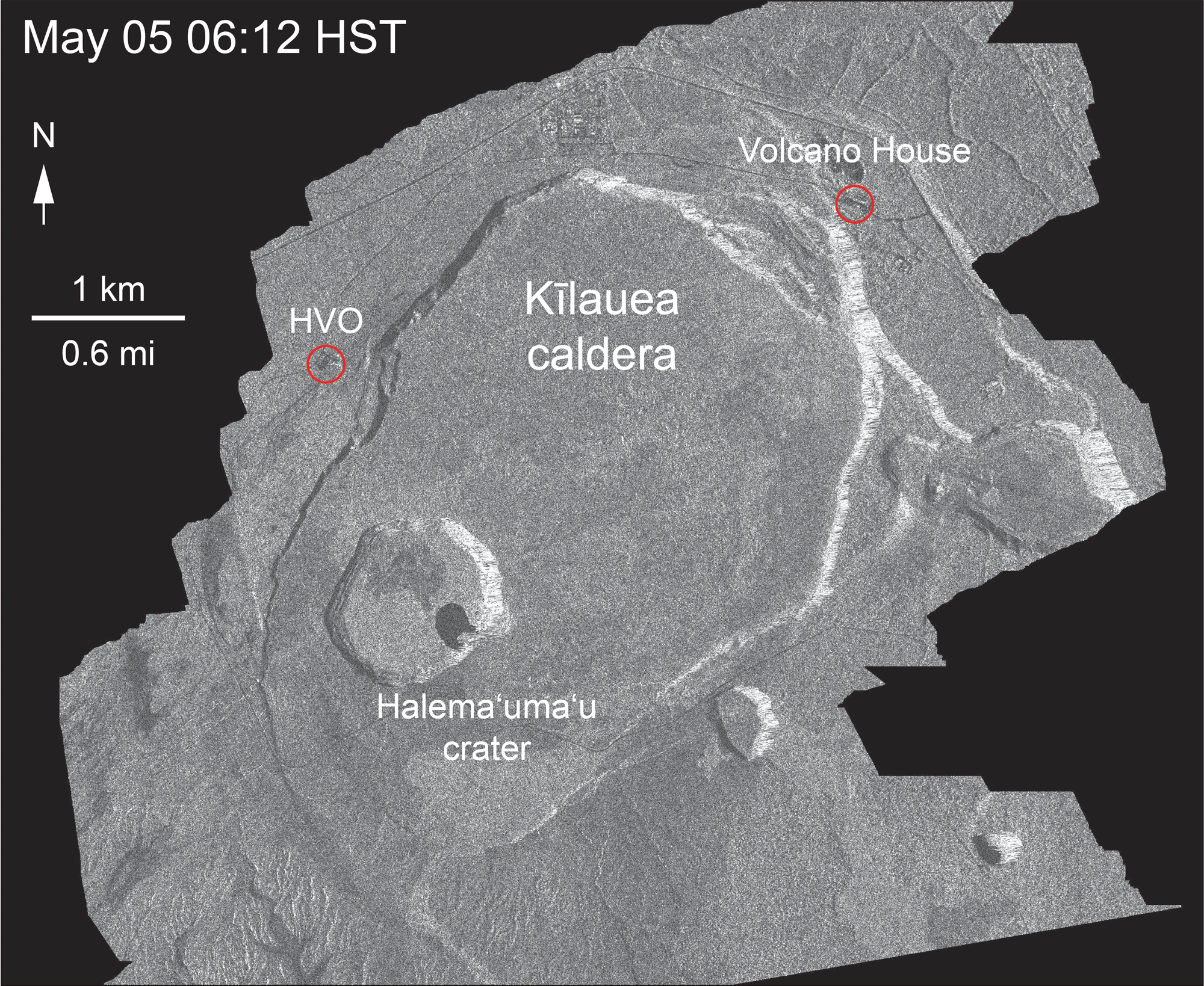
Besides Fissure 22 reactivating in earnest, the news today is that new digital elevation maps and satellite images give us a clear view of the subsidence of Kilauea Caldera around Halema’uma’u, which has begun to show in livestream and webcam views lately.
First of all, USGS seismologist Kyle Anderson posted this color-coded slide of caldera ground deformation in his Thursday evening talk:

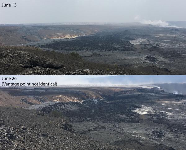
Next, the Italian Space Agency’s trusty Cosmo-Skymed satellite has sent us another radar survey of Kilauea. Even though I’d observed dramatic subsidence of the caldera floor in recent livestream and webcam images, the last frame of this animation made me gasp:
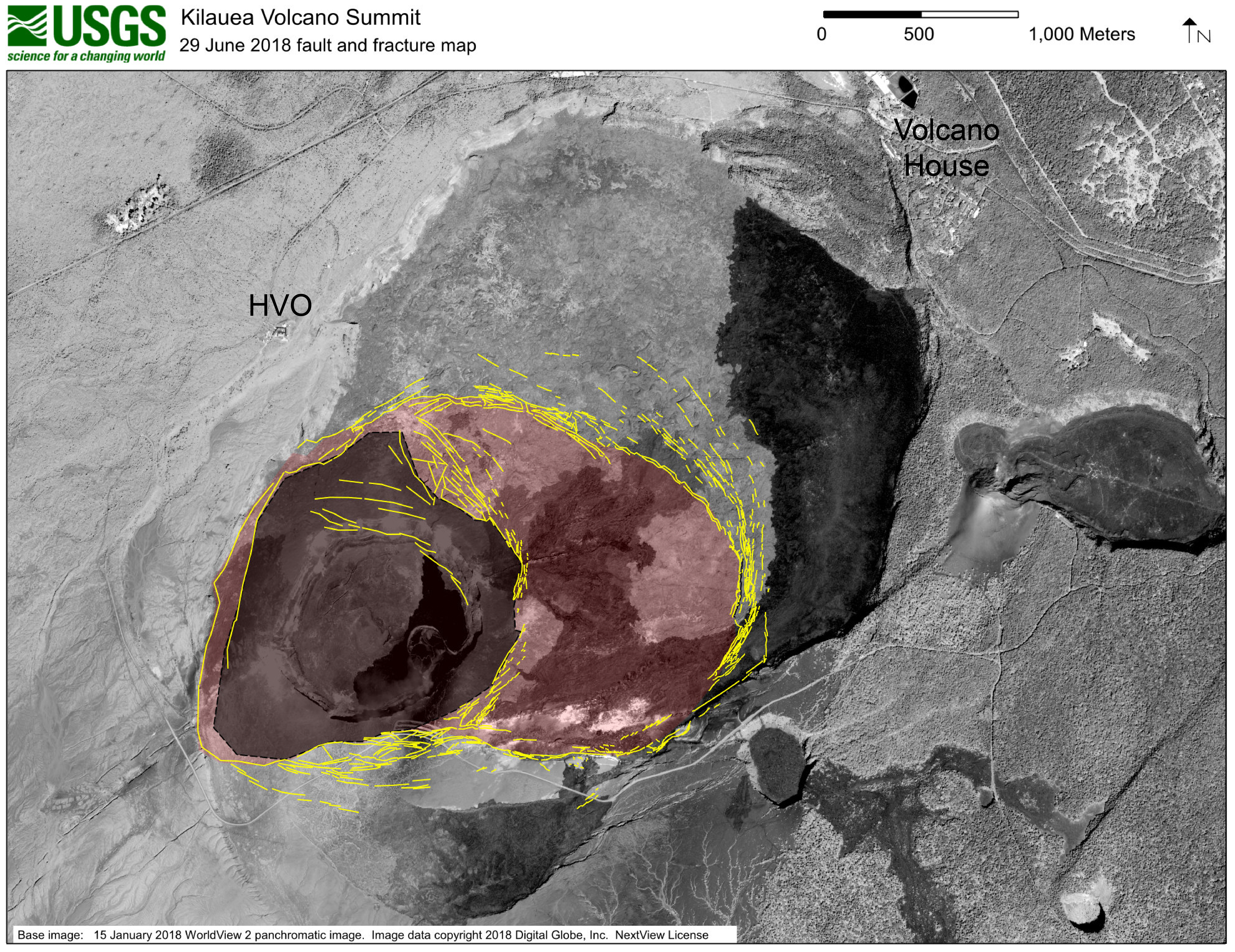
Last but not least, the USGS posted this map of the fracturing around Halema’uma’u. Note that the diagram is projected onto a satellite photo of the pre-May caldera, so there’s a ghostly image of the Halema’uma’u we remember in that dark gray area.
So there you have it. Who would’ve thought the draining of the lava lake, which was minuscule compared to the whole summit caldera, would’ve had a domino effect this large?
The rest of this post is a fairly sparse weekend roundup of a few news stories, videos and photos, plus of course the usual science geeking with USGS. Which leaves you time to browse the USGS Thursday evening talk I transcribed today!
From Local News Outlets
- HSA: “Ban on new construction in lava zones proposed“
- HTH: “Tremors change life in Volcano: With no end in sight, stress levels rise”
- HTH: “Pu’uhonua o Puna, other volunteers supporting evacuees with aloha”
- HSA: “Micro-housing shelters dedicated for displaced Lower Puna residents“
- BIVN (Video): “Lawmakers Ponder Future of Puna in Forum“
- And Dispatches from Volcano is back with another post musing on the changes from summit to sea.
Mick Kalber Overflight and lava report
See Mick’s overflight notes today accompanying this video.
USGS Q&A on Social Media
Q: What’s the estimated size and depth of the magma chamber?
USGS: There are at least two magma storage areas beneath Kilauea’s summit. The shallower is ~1.5 km below the center of the caldera and we believe houses about 1 cubic kilometer of magma. The summit subsidence is centered on this reservoir, which has probably drained to a large degree (hence the collapsing caldera floor). The second reservoir is 3-5 km down and is probably about 10 cubic kilometers in volume. We’ve seen some minor depressurization of this reservoir, but nothing like what has happened in the shallower storage area.
Q: How do you determine the magma chambers’ sizes/depths?
USGS: The locations are determined from geophysical measurements — mostly seismic and deformation results. The volumes are based on models of how those reservoirs behave over time, and they are more tentative than the locations. Determining absolute magma storage volumes has always been problematic in volcanology.
[I notice the USGS usually (but not always) says “magma storage area,” since recent research suggests it may be a network of dikes, sills and tunnels more like a bird’s nest structure than a tank.]
Q: Is it possible and safe to drill into the magma chamber?
USGS: It’s not really realistic. First of all, the site is a national park, and also a sacred place to many. Second, the expense would be enormous. There has been some effort to drill into magma chambers, most notably in Iceland.
Q: What’s the estimated depth of the collapse now?
USGS: The deepest part of the collapse is almost 400 meters [1312 feet] below the former floor of Halema`uma`u crater!
Q: What are the chances of a lava eruption at Kilauea’s summit?
USGS: During this eruption, not very likely, unless it’s in the form of ash. Much of Kilauea’s shallow magma has drained into the Rift Zone, and if it follows the pattern of past eruptions, it could take years for it to return to the summit (and form a new lava lake).
Q: What are the chances this event “caps” Kilauea?
USGS: Pretty much zero. Magma continues to enter the volcano from the hot spot, so once this event is over, the volcano will begin to refill and eventually the summit will start to reinflate. This is the sort of thing that has occurred after past summit down drops, although the current one is admittedly much more impressive than any that have occurred over the past 200 years.
Q: Can we expect more groundwater steam explosions like May 17?
USGS: We think that those explosions have largely run their course. In fact, data collected during this sequence of events suggests that the explosions were driven by decompression of the magma, since there was a lot of magmatic gas released with each explosion (we wouldn’t expect that if it were just water-hot rock interactions) — one of many things we’ve learned from this eruptive activity. But the magma seems to have lost it’s potential to drive these sorts of explosions (the vent area is also plugged), and the earthquakes now are associated with collapses of the caldera floor.
Q: When magma returns to the summit, will it have to find/create a new summit magma storage area?
USGS: Good question. The lower reservoir should remain stable, given that it is much larger and has not drained that much. But we don’t know how the site of the upper reservoir (now largely drained) will react. That will be something we watch very closely, to see if we can detect a new magma chamber forming in the act!
Q: What’s the big dark area on the nw side of the caldera floor in the “fault and fracture map”?
USGS: That’s the 1974 lava flow. It’s fresh, so has a darker coloration than the older flows of the caldera floor.
Q: Has the foreground in the livestream/webcams subsided?
USGS: It hasn’t really subsided by much — the bluff upon which HVO sits has dropped by about half a foot. That’s actually quite a lot, but nothing compared to the rest of the caldera.
Q: What did the coastline look like before the 1960 Kapoho eruption?
USGS: There’s a nice series of maps in Wikipedia that show the development of the 1960 flow over the ~month of that eruption: https://commons.wikimedia.org/wiki/Category:Maps_of_K…
From Photographers/Social Media
By the way, Bruce Omori (Extreme Exposure), Mick Kalber, and Paradise Helicopters have created a Twitter channel called @HotSeatHawaii where they livestream their overflights via Periscope:
#hawaii #eruption overflight with @Paradisecopters https://t.co/kpopLRBO92
— Hot Seat Hawai'i (@HotSeatHawaii) July 1, 2018
I don’t know how to figure out their flight schedule, but I assume it’s early morning Hawai’i time. One can watch the archived videos later. I have to admit, I’m content to browse Bruce Omori’s still photos and Mick Kalber’s edited highlights videos, but I’m old-fashioned.
Over one month and 25+ collapse/explosion events later, Kilauea is still following the same pattern pic.twitter.com/loKrn9nxzr
— Jascha Polet (@CPPGeophysics) July 2, 2018
A great cartoon was created by @USGSVolcanoes that explains this pattern in Kilauea summit seismicity and deformation pic.twitter.com/UysYgtU5ga
— Jascha Polet (@CPPGeophysics) July 2, 2018
Nice #sunrise from the summit #USGS #Jaggar #halemaumau #Hawaii #hvnp #hppa #volcano #Kilauea #lava #KilaueaVolcano #LeilaniEstates #BigIsland #eruption #Kapoho #火山 #噴火 #ハワイ #SundayMorning pic.twitter.com/Q1rn2FOBW3
— lavapix.com (@lavapixcom) July 1, 2018
“Kipuku” means an area of the pre-eruption ground isolated by lava flows on all sides. It’s usually a hill sticking up out of lava flows like an island:
The large houses kipuka's days could be over soon if fissure 22's cone keeps growing #USGS #Jaggar #halemaumau #Hawaii #hvnp #hppa #volcano #Kilauea #lava #KilaueaVolcano #LeilaniEstates #BigIsland #eruption #Kapoho #火山 #噴火 #ハワイ #SundayMorning pic.twitter.com/1qVeDlDgsC
— lavapix.com (@lavapixcom) July 1, 2018
That’s the Lower East Rift Zone cam. Hard to believe it looked like this just over a month ago:

[I haven’t seen any announcement from Civil Defense to that effect, save that “lava loiterers” are cited in mandatory evacuation zones, but then, I’m not there.]
1,500 degree molten lava hitting 78 degree water and magically creating land. (this is not in slow motion) pic.twitter.com/cd9WW85cmt
— matthew gray gubler (@GUBLERNATION) July 2, 2018
Meanwhile, in the rest of Hawai’i, life goes on:
Nice day Kona side. Minimal #vog #Jaggar #halemaumau #Hawaii #hvnp #hppa #volcano #Kilauea #lava #KilaueaVolcano #LeilaniEstates #BigIsland #eruption #Kapoho #火山 #噴火 #ハワイ #SundayMorning pic.twitter.com/fYWDXCUCsY
— lavapix.com (@lavapixcom) July 2, 2018