August 27: After Fire, Flood (Hurricane Lane)

August 22, 2018. USGS: “Parts of Kīlauea’s caldera floor are now a jumble of down-dropped blocks and surface cracks. HVO field crews carefully hiked along Crater Rim Drive yesterday to verify the locations of USGS benchmarks (lower left), which will be used for additional geophysical work that will help document the recent summit changes. The view is to the northwest with one flank of Mauna Loa visible in the distance (upper right).” (Full-sized)
Weekly Eruption Summary

After a busy few months, Kilauea continues to rest with only a pilot light on, so to speak. This week’s big news was that Hurricane Lane passed offshore of the Big Island on Thursday through Saturday, causing extensive flash flooding. But there’s still a little news to report on the dying (?) embers of Kilauea’s 2018 eruption.

On Friday morning, the Hawaii County Fire Department observed a small lava pond still visible deep in Fissure 8’s cone. For most of the week, there was no visible activity apart from a few small jets deep in the cone throwing weak spatter on Monday morning:

August 20, 2018. USGS: “This morning, USGS scientists flying over fissure 8 noticed a change in the vent from yesterday. Gas jets were throwing spatter—fragments of glassy lava (light gray deposits)—from small incandescent areas deep within the cone. This activity is an indication that the lower East Rift Zone eruption may be paused rather than pau (over).” (Full-sized)

The sputtery jets proved to be temporary:

August 21, 2018. USGS: “Southward facing aerial view of the fissure 8 cone. The two small areas of incandescence, gas jetting, and spatter from yesterday photograph appeared crusted over today.” (Full-sized)

Down at the ocean at Kapoho, there were a few weak dribbles of lava continuing to drain out of the delta at the beginning of the week:
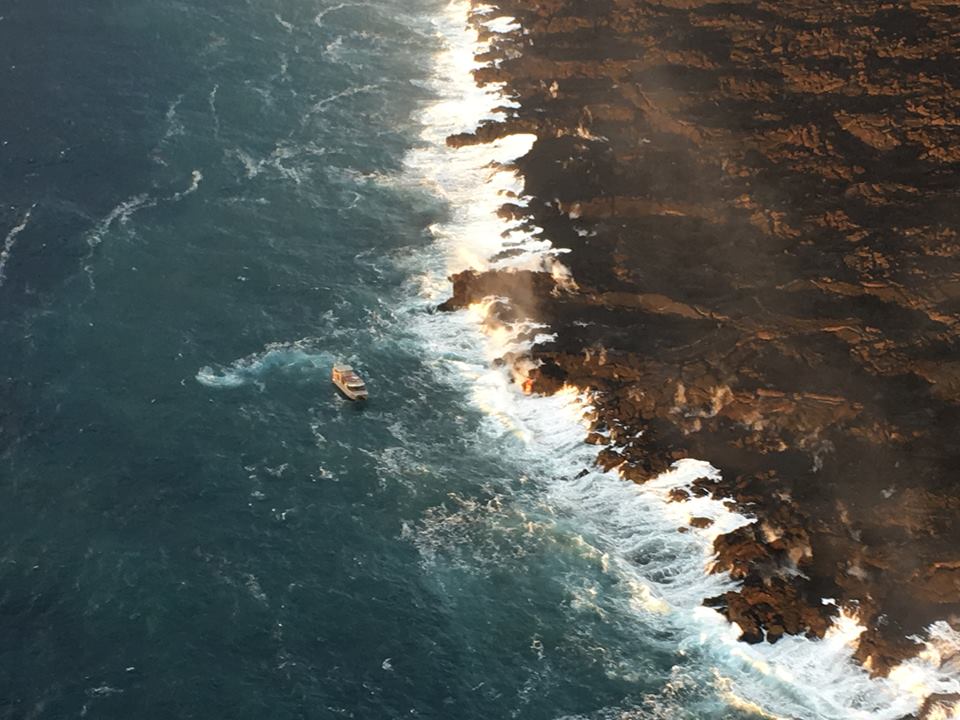
August 20, 2018. USGS photo of residual lava entering ocean, posted on their facebook page here.

Sulfur dioxide emissions continue to be very low both at the summit and the coast. In fact, on Tuesday, they dropped too low in the Lower East Rift Zone for instruments to measure, although not too low for highly-sensitive human noses to detect.

Video from August 17 posted on the 20th— full-sized version here.

Heavy rain from Hurricane Lane on Friday and Saturday put a hold on USGS overflights and field observations and knocked out a few sensors on the east side of the island. But Kilauea’s extensive sensor network means there was no gap in volcano monitoring, and field crews were on call just in case.

The hurricane had no impact on the volcano apart from heavy rainfall hitting hot rocks and turning to steam in Pu’u O’o’s crater and on the not-yet-cooled lava flows of the LERZ. There were some reports of local white-out conditions from this steam. Rain may also have triggered a few rockfalls at the summit.

The other big Kilauea news this week is that Hawaii Volcanoes National Park has set a target reopening date for September 22, aiming to reopen at least the Visitor Center and (they hope) some kind of viewing area from which visitors will be able to see the new, larger Halema’uma’u Crater. They’re also hoping to open Volcano House, but they need to check the stability of the cliffs on which it stands.

USGS Volcano Watch

Whoops! I think I missed last week’s edition. This is Hawaiian Volcano Observatory’s weekly column with photos and in-depth information on some aspect of Kilauea.

Continue reading August 27: After Fire, Flood (Hurricane Lane)

July 19: USGS Media Conference Call

Thursday 1 pm USGS briefing to media. Most important part of briefing:

Full 1/2 hour audiofile here.

  • Leslie Gordon, USGS Public Affairs
  • Janet Babb, geologist, USGS/HVO
  • Patricia Nadeau, geochemist, USGS/HVO
  • Jessica Ferracane, Hawaii Volcanoes National Park
  • Matthew Foster, meteorologist, NWS

Janet Babb, Kīlauea Update: Good afternoon, everyone.

On the Lower East Rift Zone, Fissure 8 is still active. It continues to erupt lava into the perched channel that extends down on the west side of Kapoho Crater and feeds lava into the ocean. This morning, the main ocean entry was a little bit west of Ahalanui, with the flow margin about 500 meters, or 0.3 mile, from the Pohoiki boat ramp. There’s still some weak ocean entry points to the north of this main entry over near the Kapoho Bay lobe of lava where there were some weak, wispy plumes there. The flow front along the ocean, along the coast is still about 6 kilometers wide or 3.7 miles wide. On the Lower East Rift Zone, the sulfur dioxide emissions remain high, and the ocean entry hazards include the laze plume, as well as the possible hydrovolcanic explosions, what we referred to on Monday as “littoral explosions.” Hydrovolcanic is a little more intuitive word to explain the lava-seawater interaction.

Up at the summit, as we speak earthquakes are occurring at a rate of about 25-30 per hour as the volcano builds up to the next collapse event [this phonecall at 1 pm, collapse came at 4:33 pm.] The previous collapse event weas at 1:28 am July 18, so it’s been about 36 hours. We are within that time interval where we typically see these collapses occur. At the summit, the sulfur dioxide emissions are low. We’ll be posting some new photos and a new map shortly after this media call. That’s all.

Continue reading July 19: USGS Media Conference Call

July 9: USGS Morning Conference Call

Oh good. Tina Neal herself dropped by today (I think she did some of the early ones, but she’s been understandably busy).

Here’s my transcript of this morning’s 11AM media briefing with USGS, NHS, NPS.

  • Tina Neal, USGS, Scientist-in-Charge of HVO
  • John Bradenburg, NHS
  • Jessica Ferracane, Public Affairs, HVNP
  • Janet Babb, USGS/HVO

Tina Neal, HVO: Good morning, everyone. Just to give you an update on what’s going on at Kilauea Volcano. In the Lower East Rift Zone, the effusive eruption of lava continues with little significant change from the last few days. The Fissure 8 spatter cone continues to produce a pretty vigorous river of lava in an open channel that heads to the northeast and then turns southeast, then enters the ocean about 8 miles downflow.

One of the interesting things observed by our field crews during the overflight this morning is that the channel system in the lower portion of this lava flow where it ends up into the ocean has gone through some changes. And this is an interesting phenomenon, reorganization, that we’re trying to understand. It appears at times that the channel is very vigorous all the way to the ocean, and at other times it sort of diminishes and just becomes a broad, rubbly front. As of this morning, the channel was mostly on the southern side of the flow, and the margin of the flow is expanding a little bit to the south. So there’s some very interesting channel dynamics going on in this lava flow in the lower portion that really doesn’t [act??] its behavior as it spreads out and enters the ocean.

Continue reading July 9: USGS Morning Conference Call

June 25: USGS Media Conference Call (Transcript)

[This is my own unofficial transcription. Audio file here. I’ve transcribed USGS, NPS, NWS speakers word-for-word, apart from “good morning/thank you” pleasantries. I’ve paraphrased/summarized questions from media.]

  • Leslie Gordon, Public Affairs, USGS
  • Mike Zoeller, Center for the Study of Active Volcanoes, UHI
  • Jessica Ferracane, Public Info Officer, Hawaii Volcanoes NPS
  • John Bravender, meterologist, NWS

Here’s the 3-minute “highlight reel” edited digest:

Transcript of full 20-minute call:

Continue reading June 25: USGS Media Conference Call (Transcript)

May 4: First Full Day of Eruption, 6.9 Earthquake

Friday was a busy day. Starting before sunrise, more fissures erupted (USGS night video). Here’s a USGS video of Fissure 3: first cracks, then steam, and eventually lava spatter.

At 12:33PM. a magnitude 6.9 earthquake knocked out power to some customers, agitated the summit lava lake (video clip), sent up yet more ash from Pu’u O’o (video clip), and caused minor local sea level fluctuations (Good article: Honolulu Star-Advertiser). Also see informative HVO Volcano Watch photo essay.

Below: Interview of HVO geologist Jim Kauahikaua, prior to 6.9 quake. Big Island Video News added lava footage from David Corrigan, Mick Kalber, Ikaika Marzo.

Excerpts from above interview:

Continue reading May 4: First Full Day of Eruption, 6.9 Earthquake

March 19, 2018: Ten Year Anniversary of Lava Lake in Halema’uma’u Crater

Today marked the ten-year anniversary of the opening of the “Overlook Vent” lava lake within Halemaʻumaʻu Crater at the summit of Kīlauea Volcano.

2008 and 2018 views of the “Overlook vent” lava lake within Halema’uma’u Crater.

From March 19 post of HVO’s Photo & Video Chronology archive:

Today marks the 10th anniversary of the eruption within Halema‘uma‘u at the summit of Kīlauea Volcano. When thevent first opened on March 19, 2008, it formed a small pit about 115 feet (35 m) wide. Over the past decade, that pit (informally called the “Overlook crater”) has grown into a gaping hole about 919 feet by 656 feet (280 x 200 m) in size. Click on the above webcam images to watch the growth of Overlook crater over the past 10 years.

That post also shared a slideshow of the lava lake’s formation and widening over a ten-year period:

Timelapses of Kīlauea Summit, Week of March 19

These were taken from HVO’s webcams, which at the time had been capturing images of the caldera and lava lake (“Overlook Vent”) every ten minutes for years. They give you a sense of what “normal” was for Kīlauea prior to the start of this eruption:

Views into the lava lake from two webcams that were some of the first casualties of this eruption:

At the time, there was no summit livestream.  Webcams were plenty to keep up with the day-to-day fluctuations.

USGS Video: History of Lava Lake (20 minutes)

Dr. Matt Patrick (USGS) reviews the ten year history of the overlook vent lava lake. Around 8:55 the camera pans around to show the entire lake and other parts of Halemaʻumaʻu Crater. These are some of the last views of it prior to changes in May 2018.

Wind noise makes him a little hard to hear. The USGS also posted this video on their own multimedia library. Since their server sometimes times out, let me include the transcript below.

Continue reading March 19, 2018: Ten Year Anniversary of Lava Lake in Halema’uma’u Crater