June 1: Changes to Halema’uma’u Crater

A relatively clear day, May 31, finally allowed the USGS to get good, detailed drone footage of changes at the summit.

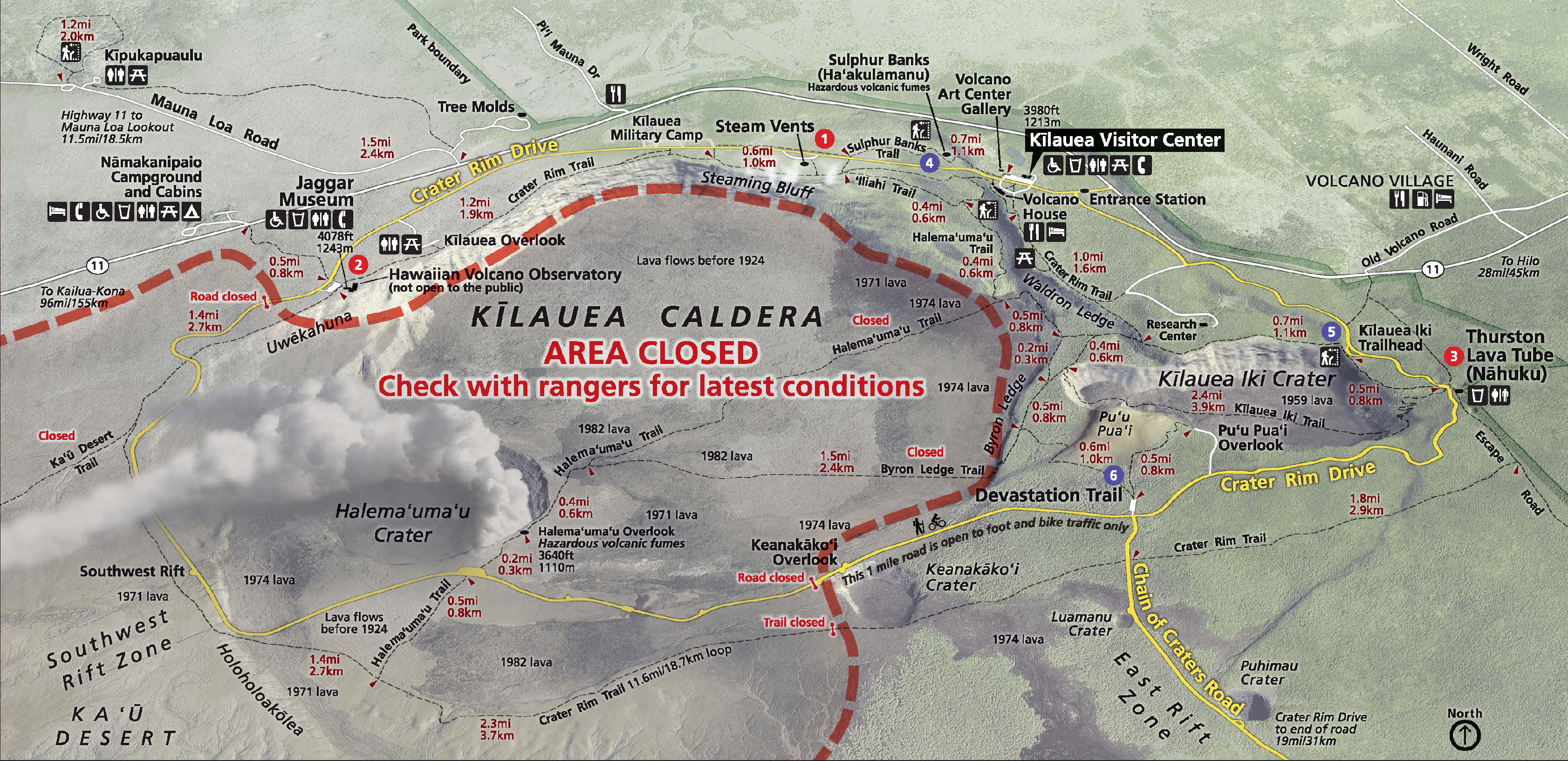
To orient you on the crater-within-a-crater-within-a-crater (Park Map):

  1. Kilauea Caldera is the megacrater, 2×3 miles across, on whose cliff walls are perched the Hawaiian Volcano Observatory, Kilauea Visitor Center and Volcano House.
  2. Halema’uma’u is a crater on the floor of Kilauea Caldera, about 2500 x 2900 feet. It held a lava lake in the 1800s, but drained and exploded in 1924, after which it was quiet for most of the 20th century.
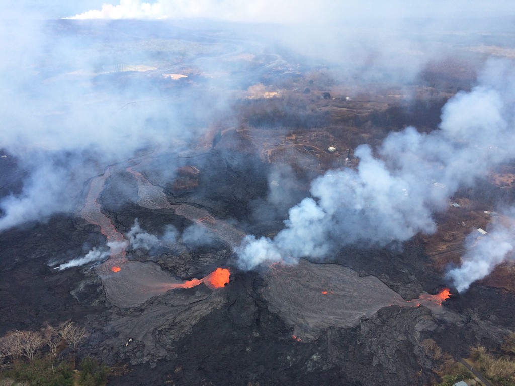
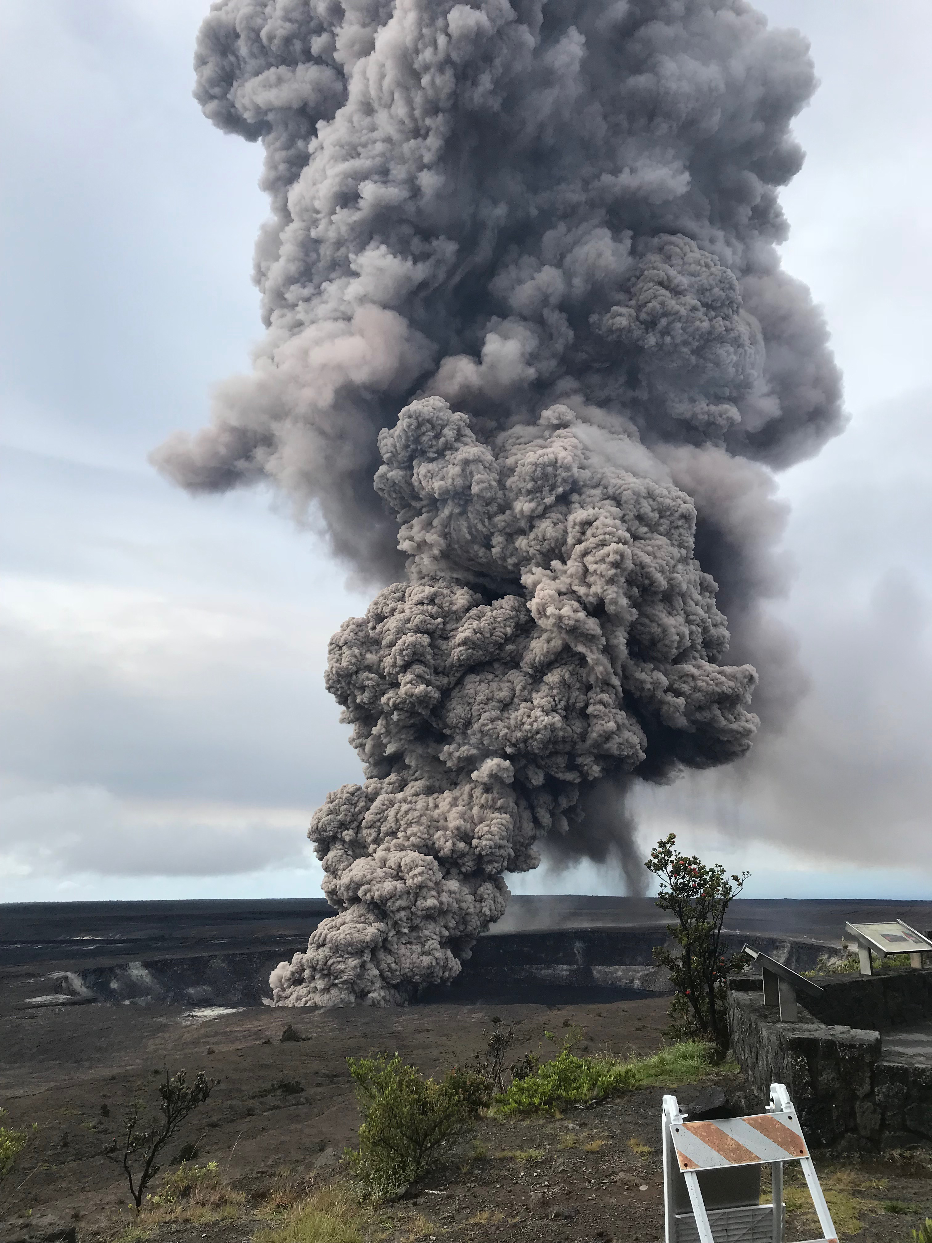
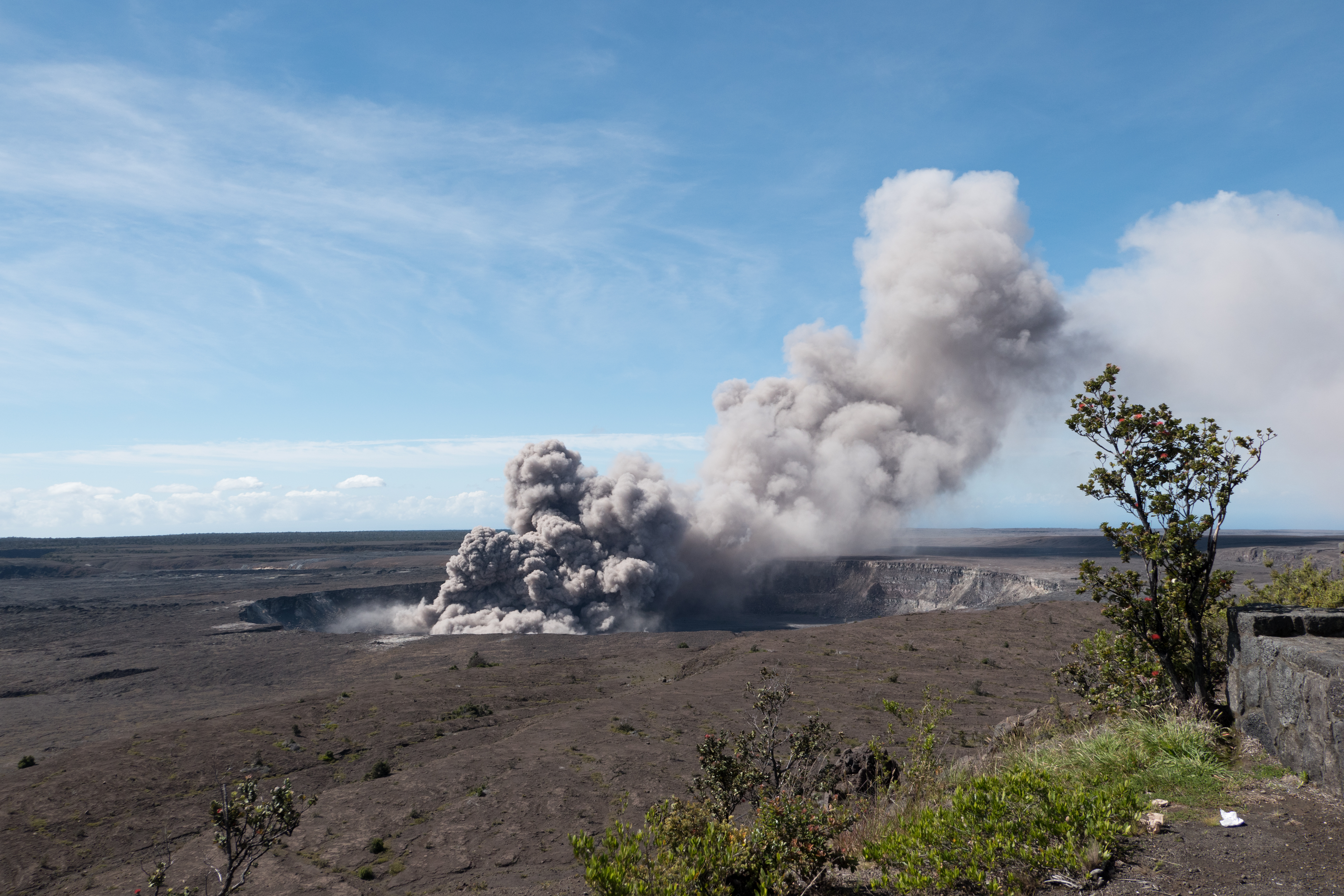
  3. The Overlook Vent was a crater on the floor of Halema’uma’u containing a lava lake from 2008 until May 2018. It drained and has been exploding with steam and ash since the beginning of May. Rockfalls from its sides have enlarged it:
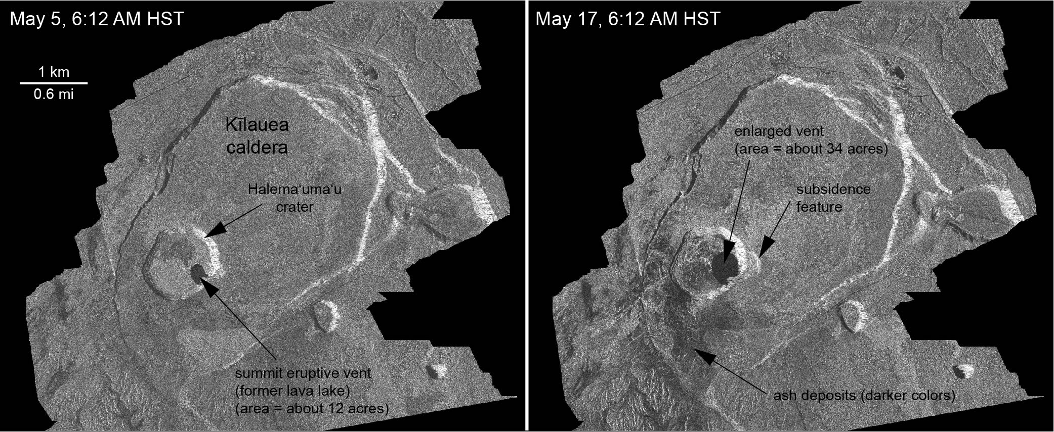
changes at kilauea’s summit, May 2018

May 5-29, USGS animation using radar data from Italian Space Agency’s Cosmo-SkyMed satellite:

May 23-31, new radar imagery shows more recent changes. The USGS caption notes that not only has the overlook vent widened, but also Halema’uma’u Crater:

USGS Animation of recent changes at Kilauea’s summit, radar images taken by Italian Space Agency’s Cosmo-Skymed satellite.


Below, a compilation of video footage of Halema’umau and its lava lake in August 2016. Go to timestamp 2:10 for a good view of Halema’uma’u Crater with the Overlook Vent’s lava lake inside. Compare that with the May 31 video above. The black area is lava that overflowed onto the floor of Halema’uma’u when the lake’s level was high.

Halema’uma’u crater and its lava lake in 2016 (USGS).

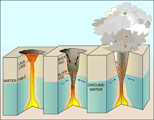
Note: the “Overlook Vent” was named after the old Halema’uma’u Overlook, because that’s the side where the lava lake vent opened in 2008. There used to be a parking lot and viewing area on Halema’uma’u’s crater rim where visitors could look down into it. In 2008, the Overlook area was closed to visitors, because whenever there was a rockfall into the lake it tended to do THIS:

May 25: End of the Road for Leilani Estates?

It looks like the coup de grace for Leilani Estates, or at least its eastern part.

USG Photo, May 25, noon overflight. Fissures 6 (left) and 13 (right) send lava flows south that join and flow down to ocean (white laze plume in distance). Note metal roof(?) embedded in lava at lower left. [Full-sized]
Three weeks ago Leilani’s streets were lacerated by fissures, battered by lava spattering from cracks, and blocked off by ponderous flows that seldom traveled far from their source. But that was a slow-motion disaster. Most fissures were active only a few hours. While a few unlucky residents lost homes in the first wave, most were able to return and collect vital possessions, or even risked dangerous fumes to stay.

Last week, the main lava activity shifted east, downrift, overrunning smaller Lanipuna Gardens, threatening the PGV geothermal plant, and inundating fields and woods where homes were more scattered.  “Hotter, fresher” magma arrived last Thursday with a roar, spurting in several-hundred foot fountains and flooding forests with rivers of fast-moving pahoehoe lava. On Saturday night, these channels reached the ocean.

It was only a reprieve. A few days ago, the fissures that had given Leilani grief began reactivating. The group of fountains monitored by HCB’s livestream began to subside as uprift vents pilfered their magma supply.  Leilani’s reinvigorated vents poured out so much lava they created a pond, as well as sending new flows down to the sea. And through people’s houses:

Today, more streets were buried. Firefighters went door-to-door urging the last holdouts to flee before lava reaches them. Even parts of lower Puna not yet menaced by lava were ordered to leave before their remaining escape routes are cut off. Just in case, authorities have sent in the Marines.

82 structures lost. A two mile stretch of fissures in a residential area is pouring out an astonishing 40-60 cubit feet per second. And yet only 3.4 square miles have been covered by lava in this eruption, on an island of over 4000 square miles. But that doesn’t make it any easier for those affected.

Below, a roundup of Friday’s images, videos, USGS news, and reports from local news stations.

Continue reading May 25: End of the Road for Leilani Estates?

May 24: USGS Acquires Drones, Leilani Estates Acquires Lava Lake

Before this, the main thing USGS was using drones for was LIDAR, but today’s Photo & Multimedia entry on HVO’s website provides drone footage for both the summit steam/ash plume and Leilani/Puna lava flows.

SUMMIT ERUPTION:

This video was filmed on May 21, 2018, with a UAV (unmanned aerial vehicle). Limited UAV flights above the hazardous Kīlauea summit area, which is currently too dangerous for geologists to enter for ground observations, are conducted with permission from the National Park Service. […] At Kīlauea Volcano’s summit, a nearly continuous plume of gas and steam billows out of the Overlook vent and drifts with the wind. Explosions are occurring about two times a day, producing ash that rises to a height of between 8,000 to 10,000 feet above sea level. Small ash emissions occur more frequently. The larger explosions produce ash that is blown downwind, and trace amounts have fallen in nearby communities.

Addendum: there was a 6PM 10,000 foot ash explosion & plume this evening (Civil Defense photo, USGS video), sending ash southwest.

PUNA LAVA ERUPTION:

This footage is from an Unmanned Aircraft System (UAS) hovering near fissure 22 during the overnight hours of May 22, 2018, and looking down on the fountaining fissure complex. The view rotates upward (to the south) to track channelized lava as it flows toward the Pacific Ocean, about 3 mi (5 km) away. The ocean entry is in the distance, recognizable by a small plume. The USGS National Unmanned Aircraft Systems Project Office is assisting with remote data collection and mapping of lava flows and hazards…

HVO’s Photo & Multimedia blog also posted impressive Hilo Civil Air Patrol aerial photos of the lava rivers from yesterday, as well as an image of Fissure 22 taking a nap (it’s still going but lower today on Civil Beat’s Livestream) while the fissures west of it (and uprift) that activated yesterday inundated Leilani Estates.

As an aside: people keep posting ridiculous rumors, so the USGS had to reassure everybody that Mauna Loa is NOT erupting.

Latest video this evening from HNN reporter Mileka Lincoln:

Earlier in the day… welcome to the Leilani Estates Lava lake. (warning: noisy)

The residents are being absolute champs in coping with this. Here’s another video clip of the lava lake with the homeowner whose home is just outside of it. They’re very philosophical, realizing they took a gamble, which is more mature than some of the people criticizing them for taking a chance on a place that hasn’t had an eruption in about 60 years. And they’re helping one another.

Oh, my mistake. It’s a lava pond.

Mick Kalber’s helicopter overflight video today does a great job of showing the “pond,” the fissures headed from there past the geothermal plant, and the lava rivers flowing south from those fissures towards the ocea.

USGS Updates, News Roundup, And More Vivid Videos:

Continue reading May 24: USGS Acquires Drones, Leilani Estates Acquires Lava Lake

About the 1790 Kilauea Eruption

Here’s a summary and primary sources collected by HVO geologist Don Swanson on a 1790 explosive episode of Kilauea.

Also see USGS factsheet, “Explosive Eruptions at Kilauea, Hawai’i?” compiled prior to the 2018 eruptions. Diagram from this page:

3-part diagram: at left, a full lava lake with a long chimney of magma supplying it from below; in the middle is the same lava lake with the lava level dropping way down the chimney, below the water table, so that the upper walls of the chimney are cool enough for groundwater to seep in. Rocks falling from the chimney's walls are starting to choke it. The third and last phase of the diagram shows that groundwater has heated to steam and built up pressure below the rockfall until it builds up enough steam to shoot the blockage straight up out of the chimney.
USGS Diagram Explaining Cause of Steam Eruptions

The factsheet notes that “Many of Kilauea’s pre-1924 explosive eruptions that produced significant ash deposits probably happened when the volcano’s summit crater was so deep that its floor was below the water table, letting ground water seep in to form a lake.

If I’m understanding correctly, they’re saying that bigger explosions may happen when there’s a lake of water, i.e. more fuel to create steam.

Edited to add: HVO’s page outlining the history of Kilauea Caldera also goes into past explosive episodes. Final paragraph:

“Having pieced together the recent geologic past of Kīlauea, scientists conclude that the volcano will eventually return to a long period of mostly explosive activity, just as it did around 1500 CE. This future explosive period will probably accompany a significant decrease in the magma supply rate and be initiated by collapse of a new caldera to the depth of the water table, which today is about 615 m (2015 ft) below the present high point on the caldera rim. For now, effusive eruptions dominate Kīlauea.”

Note: that’s a new caldera, the much larger basin containing Halema’uma’u crater within it, and the vent that’s erupting ash explosions right now was a small lava lake covering only part of the floor of Halema’uma’u. Orders of magnitude different in terms of size. Also, changing the location of the active vent doesn’t mean the magma supply inside is dropping.

May 9-10: USGS Warns of Possible Steam Explosions

Attention shifted back to the summit on May 9, when a 3.1 earthquake set off a rockfall that agitated the lava lake and sent up a 6000-foot poof of ash (video clip National Parks site):

Rockfall into Halema’uma’u lava lake sends up plume of ash, 8:27 May 9.

Rockfalls caused poofs of ash like this even back when the lava lake was full, but that was more than usual. (See also USGS video from May 7, when lava lake was still visible, showing how falling rocks agitate it).

However, that was just a teaser. The big news was the dropping lava lake…

…prompted HVO to issue its first warning about steam explosions if the lava dropped below the water table.

Hawaii Volcanoes National Park closed Friday May 11 as a precaution, since the lava lake was projected to reach the water table sometime that day. For the next few days it continued to send up a white plume of steam and/or ash clouds when rocks from the sides of the chimney fell in:

[USGS] May 11, 9:12 AM: second ash explosion
On steam (phreatic) explosions:

Continue reading May 9-10: USGS Warns of Possible Steam Explosions

May 5: Pu’u O’o, Before and After

Screencaps from Mick Kalber flyover videos April 28 and May 4(?) as noted by @ReelNewsHawaii on Twitter.

Apr 30: Pu’u O’o Crater Collapse

The floor of Pu’u O’o collapsed in stages starting at 2PM in the afternoon and evening of April 30. Poor weather, fog and clouds obscured the view, but the thermal webcam positioned on Pu’u O’o’s  north rim captured it. Timelapse April 28-May 1:

This isn’t the first time it’s collapsed. Here’s a regular webcam timelapse movie of Pu’u O’o’s crater floor collapsing on March 5, 2011.

So there’s a chance the lava may return.


April 30: Halema’uma’u Lava Lake Before It Dropped

Amateur video of Halema’uma’u lava lake in Overlook Crater, taken by Jeffrey Brown on April 30, 2018.

The week before, the summit had been inflating and the lava lake had been overflowing, as seen on this USGS timelapse video of Halema’uma’u Crater April 25-26.

Map of Halema’uma’u and Kilauea Summit, because it’s a little confusing:

Continue reading April 30: Halema’uma’u Lava Lake Before It Dropped

Apr 28: Pu’u O’o Lava Lake

Pu’u O’o: What it looked like just before it collapsed. See also this USGS timelapse movie of Pu’u O’o’s crater lava lake from March 20-April 18, and a blog post with a few good flyover photos on April 29.

(Pu’u O’o is a large vent on Kilauea’s shoulder that’s been erupting since 1983. See USGS / HVO photo history of the Pu’u O’o eruption.)