June 27: Farm Animals Airlifted

Prelude

Here’s an excellent 13-minute retrospective of Kilauea’s eruptions from the early 20th century right through June 25, 2018.

Now back to the present.

Today’s Eruption Summary
USGS: “At 10:41 p.m. HST on June 26, after approximately 25 hours of elevated seismicity, a collapse explosion occurred at the summit producing an ash-poor steam plume that rose less than 1,000 ft above the ground surface before drifting to the southwest. The event was captured by an HVO webcam in moonlight (plume in bottom of photo), located in the HVO observation tower.” (Full-sized)

It’s 11:30pm HST, and it looks like today’s “collapse explosion” is going to happen tomorrow. Are the explosion spacing themselves out more now?  Too early to tell. There has been always some variation in their timing, despite the fact that it feels like we’re watching a magmatic equivalent of Old Faithful.

View of Fissure 8 cone and lava channel from USGS morning overflight. (Full-sized)

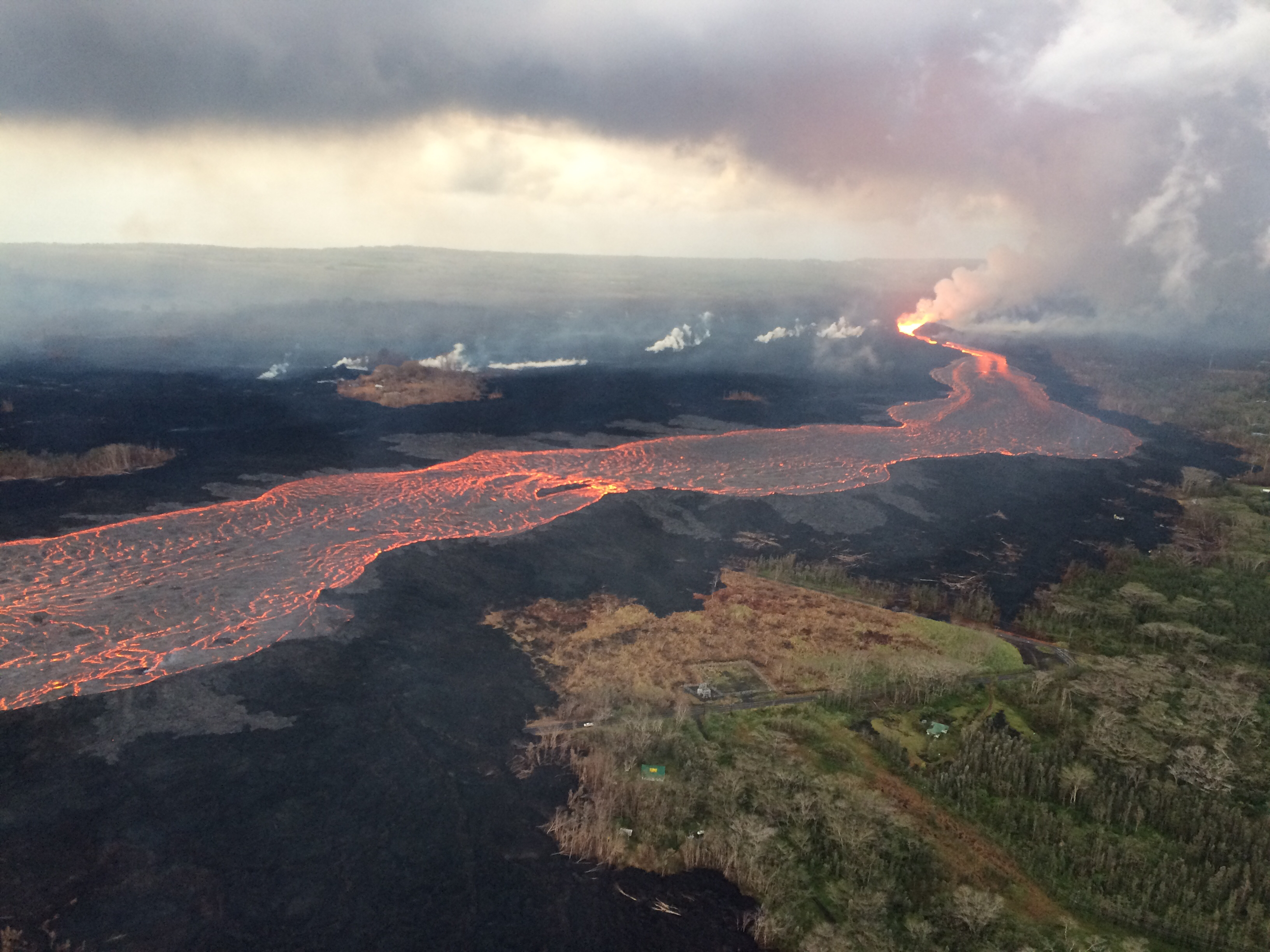
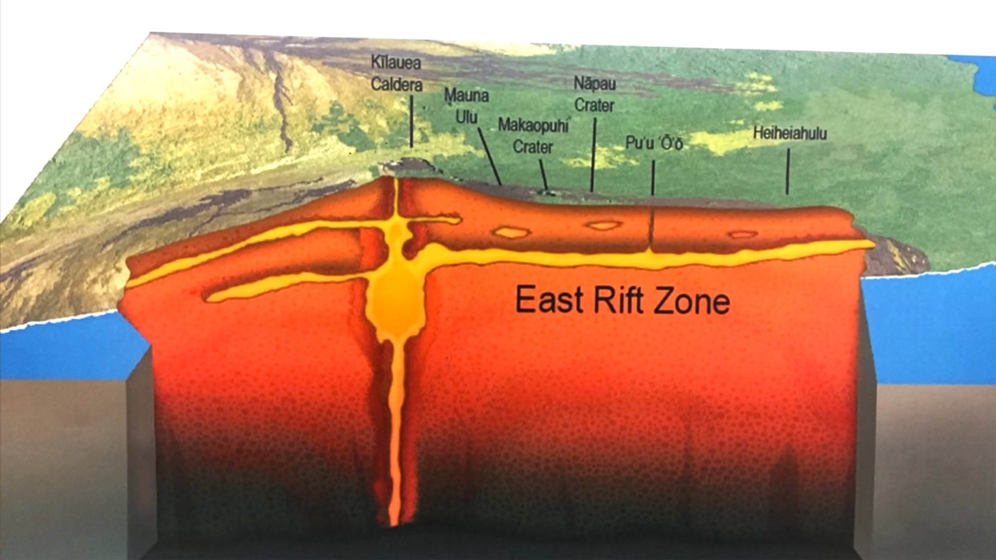
Meanwhile, Fissure 8 continues exactly what it has for— what, a month now? Fountains contained within its 180-foot spatter cone continue to pour out an 8-mile river of lava. Occasional spillovers near the head of the river usually don’t go past the margin of previous flows in this eruption. Fissure 22 is once again showing “incandescence” and pushing out small, short lava flows.

The ocean entry area fans out across a 1-km stretch of coast, but the bulk of the lava is dumping into the sea from Fissure 8’s main channel. Unfortunately, the northern margin of the lava flow has reactivated, too, pushing further into what’s left of Kapoho Beach Lots community.

USGS on Twitter: “Morning overflight revealed northern margin of flow field at the coast is oozing fresh #lava at several points in the area of #KapohoBeachLots. Small channel overflows feed short #pahoehoe flows.” (Full-sized)

USGS: “Lava continues to enter the sea along the southern Kapoho coastline. Lava enters the ocean primarily through an open channel, but also along a 1-km (0.6 mi) wide area. Also visible in the image (center right) is an area at the northern margin of the flow field that is oozing fresh lava at several points in the area of Kapoho Beach Lots.” (Full-sized)

And that’s about it. Except that even with status quo, there’s some unusual sights and itoday. Such as this literal “Lava boat”:

Continue reading June 27: Farm Animals Airlifted

June 12: Steve Brantley (USGS) Weekly Talk on Eruption

I didn’t realize I’d missed one of Steve Brantley’s excellent 10-minute slideshow presentations at the weekly Puna Community Meetings. This one took place on Tuesday, June 12 at Pahoa High School.

I learn something from every one of these talks, which sum up Kilauea eruption activity of the past week in a way that’s easy for the general public to understand without talking down to them.

Video of meeting is archived here. Steve’s presentation starts at timestamp 42:10. Where possible, I’ll be including images in my transcript which match his slides.

(Steve Brantley is a USGS geologist, deputy-scientist-in-charge of Hawaiian Volcano Observatory.)

Transcript

Hello everybody. Thank you for coming out again and thank you for your perseverance. I’ll show a couple slides of what’s been happening down in this part of the neighborhood and end with some slides of the summit area, which continues to change very dramatically.

Cutaway Diagram of Kilauea Volcano, adapted from USGS Characteristics of Hawaiian Volcanoes. (I’ve adjusted text and drawn arrow to match Steve Brantley’s slide in his presentations.)

So this is  the overview slide I’ve showed for the past few times. It gives you the overall picture. It’s an image, cartoon, from the summit area all the way out to the eastern tip of the island. The summit area here [under “Kilauea Caldera” label], eastern tip [down by “Kapoho Crater”], with a cross section showing you the general picture of the magma reservoir system from the summit of the volcano down through the East Rift Zone and into the Lower East Rift Zone.

Continue reading June 12: Steve Brantley (USGS) Weekly Talk on Eruption

Pele’s Path: Eyewitness to History

HawaiiNewsNow has had the most in-depth and on-the-ground local coverage. Wednesday night they aired a half-hour documentary, Pele’s Path: Eyewitness to History.

Hawaii News Now – KGMB and KHNL

It’s a day by day look at how this has unfolded for the shaken residents of Puna, for the state officials scrambling to address this fast-moving crisis, and for those who are front-row witnesses to the power of nature at its most destructive… and yet beautiful.

May 23: USGS Presentation on Puna Lava Eruption So Far

Tuesday evening, USGS Volcanologist Steve Brantley gave a  presentation in Pahoa High School. A lot of it is fairly simple, recapping the eruption for residents of Puna. I’ve covered most of what he does in previous posts. But there are a few new tidbits.

His takeaway is worth seeing if you don’t read/watch the rest:

…until that balance is reached, or something else changes, we expect magma to continue moving from the summit reservoir into the rift zone and further down into the Lower East Rift Zone. So that suggests that we’re in it for the long haul. We don’t know how long this eruption’s going to last, but for now, it looks like it’s just going to continue.

Full transcript below the cut.

Continue reading May 23: USGS Presentation on Puna Lava Eruption So Far