Prelude
Here’s an excellent 13-minute retrospective of Kilauea’s eruptions from the early 20th century right through June 25, 2018.
Now back to the present.
Today’s Eruption Summary
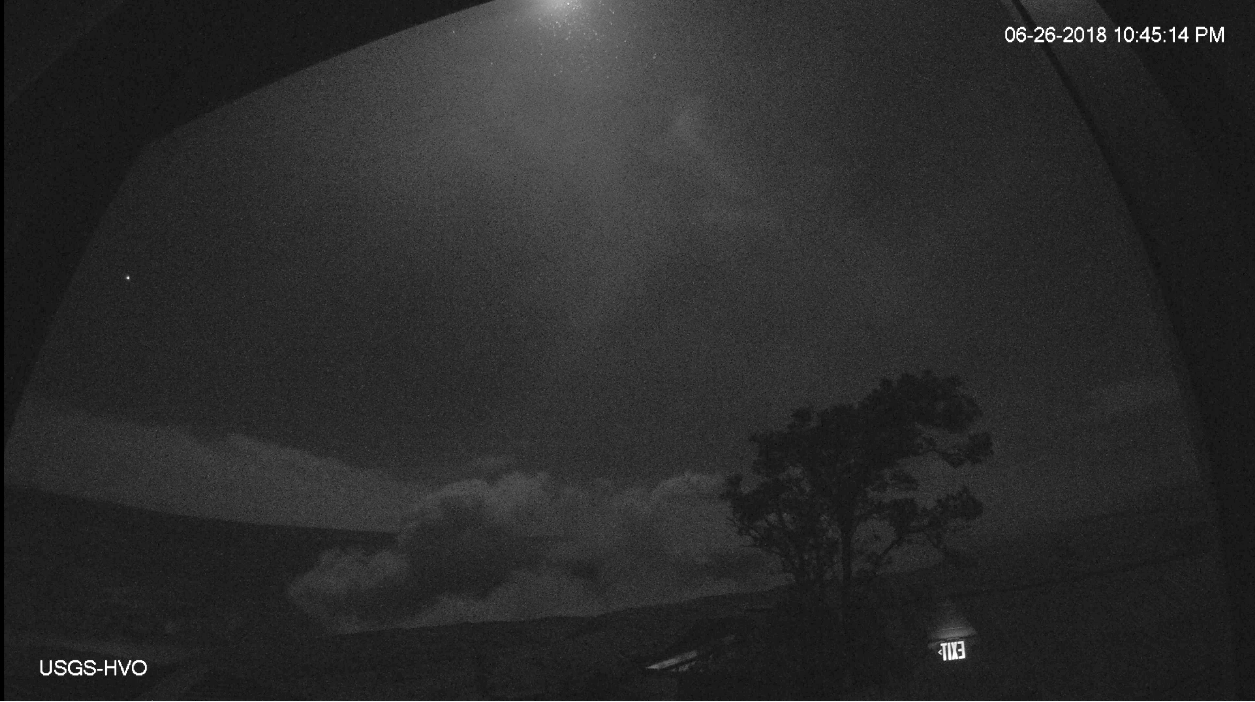
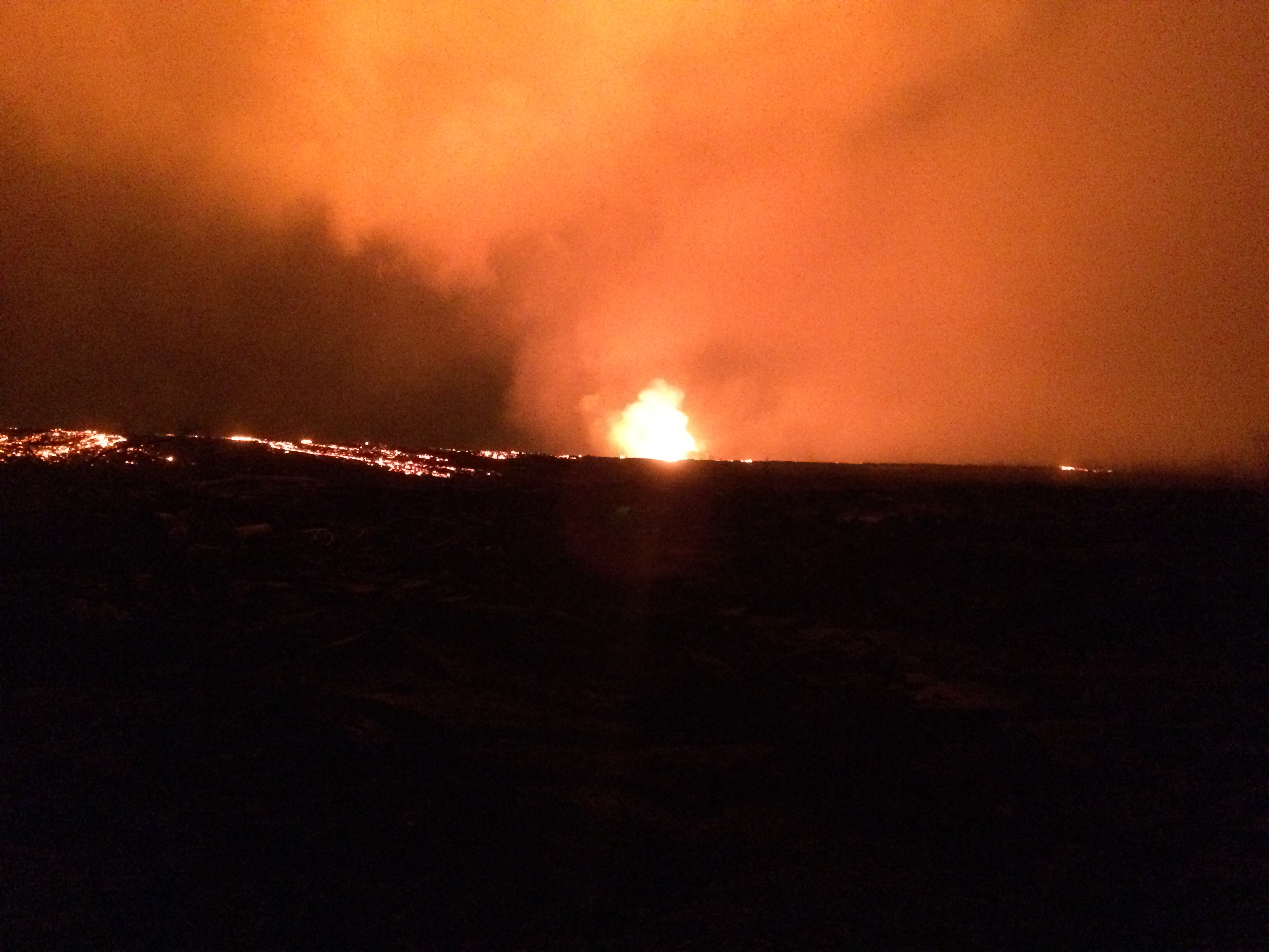
It’s 11:30pm HST, and it looks like today’s “collapse explosion” is going to happen tomorrow. Are the explosion spacing themselves out more now? Too early to tell. There has been always some variation in their timing, despite the fact that it feels like we’re watching a magmatic equivalent of Old Faithful.
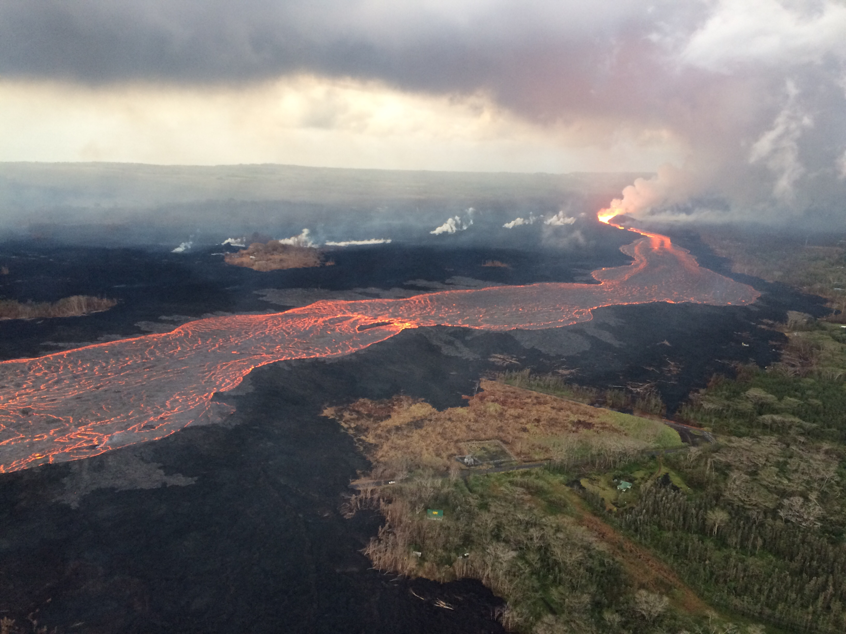
Meanwhile, Fissure 8 continues exactly what it has for— what, a month now? Fountains contained within its 180-foot spatter cone continue to pour out an 8-mile river of lava. Occasional spillovers near the head of the river usually don’t go past the margin of previous flows in this eruption. Fissure 22 is once again showing “incandescence” and pushing out small, short lava flows.
The ocean entry area fans out across a 1-km stretch of coast, but the bulk of the lava is dumping into the sea from Fissure 8’s main channel. Unfortunately, the northern margin of the lava flow has reactivated, too, pushing further into what’s left of Kapoho Beach Lots community.

Eruption Update for June 27 at 4PM. Due to active lava near houses in Kapoho, access by residents is not allowed. No additional houses have been destroyed at this time.
— Mayor Harry Kim (@MayorHarryKim) June 28, 2018

And that’s about it. Except that even with status quo, there’s some unusual sights and itoday. Such as this literal “Lava boat”:
#LeilaniEstatesEruption #KilaueaVolcano LATEST: #IkaikaMarzo captures the phenomena that USGS has named a “lava boat”. Watch as it makes its way down the #Fissure8 lava river in Kapoho and then breaks apart 😳 https://t.co/66DxdlXUzZ @HawaiiNewsNow #HINews pic.twitter.com/bAQK1uYyJh
— Mileka Lincoln (@MilekaLincoln) June 28, 2018
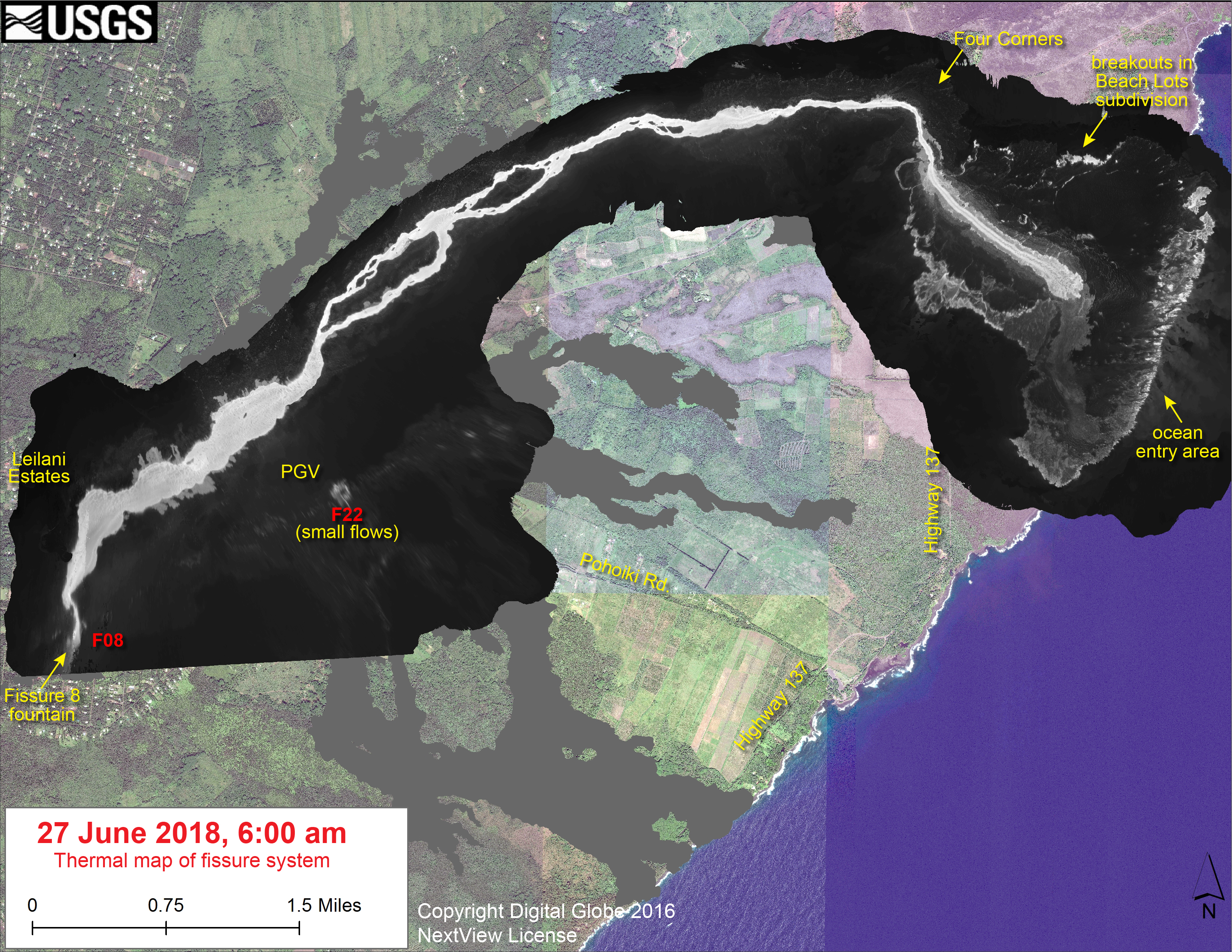
Today’s Lava Field Map
USGS FAQ on summit earthquakes
- They haven’t announced this yet, so they’re probably passing it around for final review and tweaks, but look what I just found buried on the HVO website, uploaded yesterday:
Frequently Asked Questions About Kilauea’s Summit Earthquakes
USGS Q&A on Social Media
Another reassuring comment on the ongoing collapse events: “This has happened many times before at Kilauea (see https://volcanoes.usgs.gov/volcanoes/kilauea/geo_hist_summary.html ). While different kinds of explosive activity are associated with a very deep caldera, we’re not anywhere near that point yet.”
Q: You say the “Overlook vent” [lava lake] is gone. Looks like Halema’uma’u is gone, too.
USGS: “Not just yet. Halema’uma’u is still visible as a nested crater within the larger Kilauea Caldera.”
Q: If the caldera drops another 200 meters, would an acidic boiling lake form in the bottom?
USGS: When this occurs at other volcanoes, it’s usually in ones that have not had active eruptions at the surface in some time. At Kilauea, which is still very hot in the shallow subsurface, that water would likely boil away before it had a chance to form a lake.
Q: If summit explosions are “ash poor,” then what’s in them?
USGS: The recent plumes have been largely composed of rockfall debris (ground-up rock fragments from the walls of the crater). Earlier in the explosive eruption sequence, we were seeing ash that had been fragmented by the explosions themselves.
Q: Will explosive eruptions end if enough rubble collects to cut off groundwater from hot material below?
USGS: At the moment, we’re not sure it’s predominantly groundwater-driven, but we’re still debating what’s driving it. Infilling of the crater cutting off the explosive events entirely is a possibility, but it’s not guaranteed.
Q: Is there a relationship between the material lost at the summit and the amount of lava erupted from the fissures?
USGS: Theoretically, it’s a direct relationship. However, in reality not all the magma from the summit or Pu’u O’o will erupt from the fissures. In this eruption, andesitic lava, which had clearly been sitting around in the rift for a while, erupted early on in the fissure activity.
Q: When was the last eruption of magma from the summit? When is the last time it got taller?
USGS: Since an ‘eruption’ is defined in a very basic sense by lava coming out of a vent, it was technically back in April of this year, when overflows were occurring at Halema’uma’u. As for the last time the volcano got taller, that was around 1000 to 1500 CE: https://volcanoes.usgs.gov/volcanoes/kilauea/geo_hist_summary.html
Q: I have a piece of lava rock that’s very light. Does lava ever harden enough to build on it?
USGS: Yes, much of the lava in Hawai’i is much more dense than the rock you mention (which sounds like it was pumice, a very bubbly and light form of lava). In many places, buildings are constructed direction on top of lava flows that were emplaced only decades before.
In Place of Mick Kalber’s Overflight Video
Paradise Helicopter’s chef lava pilot was busy with a tricky rescue operation today: airlifting livestock! There’s one surreal image in this video that’s going to stick with me from this eruption:
Accompanying the vid is a short article by Bruce Omori, one of the Paradise Helicopter frequent flyer photographers. He mentions the GoFundMe for KapohoLavaRescue.
From Local News Outlets
- HTH: “Lava expected to reach at least two Kapoho homes today”
- HNN: “Kilauea’s ongoing eruptions are rewriting its past and helping scientists better predict its future”
- BIN: “Ocean Robots Collect Data From Kilauea Flow”
- BIN: “Research on Impacts of Lava Ocean Entry Underway”
- HCB: “Big Island: Puna Residents Set Up This Awesome Center For Volcano Refugees”
- HTH: “Ige’s comments create confusion over possible lava viewing site”
- HNN: “FEMA disburses more than $100K in individual aid to lava evacuees”
#LeilaniEstatesEruption #KilaueaVolcano UPDATE: The most recent image of the #Fissure8 flow taken just an hour ago captures lava encroaching mauka of Kapoho Beach Lots, flanking channel entering the ocean at #KapohoBay @https://instagram.com/p/BkiXnLPg9wk/ @HawaiiNewsNow #HINews pic.twitter.com/kY2Qi74ZQM
— Mileka Lincoln (@MilekaLincoln) June 27, 2018
From a Not-So-Local News Outlet
Sierra Club: “Coral Reefs Lost to Kilauea Eruption”
This article is a week old, but it covers some wildlife impacts I haven’t seen mentioned elsewhere.
Photographers and Social Media
It's good to be back in Leilani Estates, got back last night. Fissure 8 is simply overwhelming. #LeilaniEstates #Kilauea pic.twitter.com/9wQxzdRr5H
— Dane duPont (@GeoGolfHawaii) June 27, 2018
What’s left of a neighborhood in the Leilani Estates area from the destruction of what the Kilauea Volcano and the Lava Flow coming from Fissure 8 has caused.
Link in profile bio to support the local community.#natgeo #natgeotravel #pegasusaerials #ha… https://t.co/SFxVSdoUxc pic.twitter.com/pw0SGiQRsX
— Toby Harriman (@tobyharriman) June 28, 2018
Here’s those earlier lava flows to the ocean from before Fissure 8 took off, crossing Kalapana-Kapoho Rd just SW of Mile Marker 13:
Posted by Andrew Hara on Tuesday, June 26, 2018
Volcanic sky a couple of nights ago. Win this print July 1st – Check bio for how to win 🤙 tag some friends below 👍
.
.
.#hawaii #volcanic #volcano #art #lavaart #instagood #instalike #kilauea #bigisland #paradise #leilaniestaes #pahoa #eruption #poi… https://t.co/0QEx9ZqB9r pic.twitter.com/QULWb0n5uj— PoinaView 观点看法official (weibo) (@PoinaView) June 28, 2018
When not documenting cowlifting, Bruce Omori took a swing past the coast to check on today’s flow expansion.
Wednesday, June 27, 2018, 5:45 am – Kilauea's east rift zone overflight: A stunning amount of lava enters the sea at…
Posted by Extreme Exposure Fine Art Gallery on Wednesday, June 27, 2018
In addition to the usual dramatic overflight photos, Bruce Omori posted several photos of the new breakouts today with streets labeled. There’s more like these:
Wednesday, June 27, 2018, 5:45 am – Kilauea's east rift zone overflight: Active flows once again threaten homes and property in the Kapoho farm and beach lots.
Posted by Extreme Exposure Fine Art Gallery on Wednesday, June 27, 2018
Wednesday, June 27, 2018, 5:45 am – Kilauea's east rift zone overflight: Lava once again threatens homes and property…
Posted by Extreme Exposure Fine Art Gallery on Wednesday, June 27, 2018
Wednesday, June 27, 2018, 5:45 am – Kilauea's east rift zone overflight: A section of the channelized flow that has begun ponding, and overflowing its edges, sending lava laterally.
Posted by Extreme Exposure Fine Art Gallery on Wednesday, June 27, 2018
Wednesday, June 27, 2018, 5:45 am – Kilauea's east rift zone overflight: With clouds forming before our eyes over the…
Posted by Extreme Exposure Fine Art Gallery on Wednesday, June 27, 2018
Wednesday, June 27, 2018, 5:45 am – Kilauea's east rift zone overflight: The massive channelized flow has isolated the…
Posted by Extreme Exposure Fine Art Gallery on Wednesday, June 27, 2018
Wednesday, June 27, 2018, 5:45 am – Kilauea's east rift zone overflight: Fissure 22 remains active, as light spattering was observed as we hovered over the river.
Posted by Extreme Exposure Fine Art Gallery on Wednesday, June 27, 2018
Wednesday, June 27, 2018, 5:45 am – Kilauea's east rift zone overflight: Love this perspective of the channel. 🙂
Posted by Extreme Exposure Fine Art Gallery on Wednesday, June 27, 2018
Last but by no means least, I’ve been enjoying Brian Lowry’s volcano photography on his own website for many years.
New blog post & images from my last few helicopter charters over the eruption area https://t.co/Ai9s5HJN6q #halemaumau #Hawaii #hvnp #hppa #volcano #Kilauea #lava #KilaueaVolcano #LeilaniEstates #BigIsland #eruption #Kapoho #火山 #噴火 #ハワイ #wordpress #blog #Wednesday
— lavapix.com (@lavapixcom) June 27, 2018