At a public talk in Pahoa, Hawaiian Volcano Observatory Deputy-Scientist-in-Charge Steve Brantley gave a 10-minute talk on the 2018 Kilauea eruption sequence so far.
I was going to summarize it in my June 6 Kilauea daily digest. However, it’s so useful I’ve transcribed it in full below.
The full community meeting is archived here, with Steve Brantley’s presentation starting at 44:30. BigIslandVideoNeed has excerpted it below, but they don’t usually show the slides he was showing. I’m going to be putting those back in, matching or approximating the photos he selected.
Steve Brantley, HVO/USGS: “Good evening and thank you for coming out tonight. […]
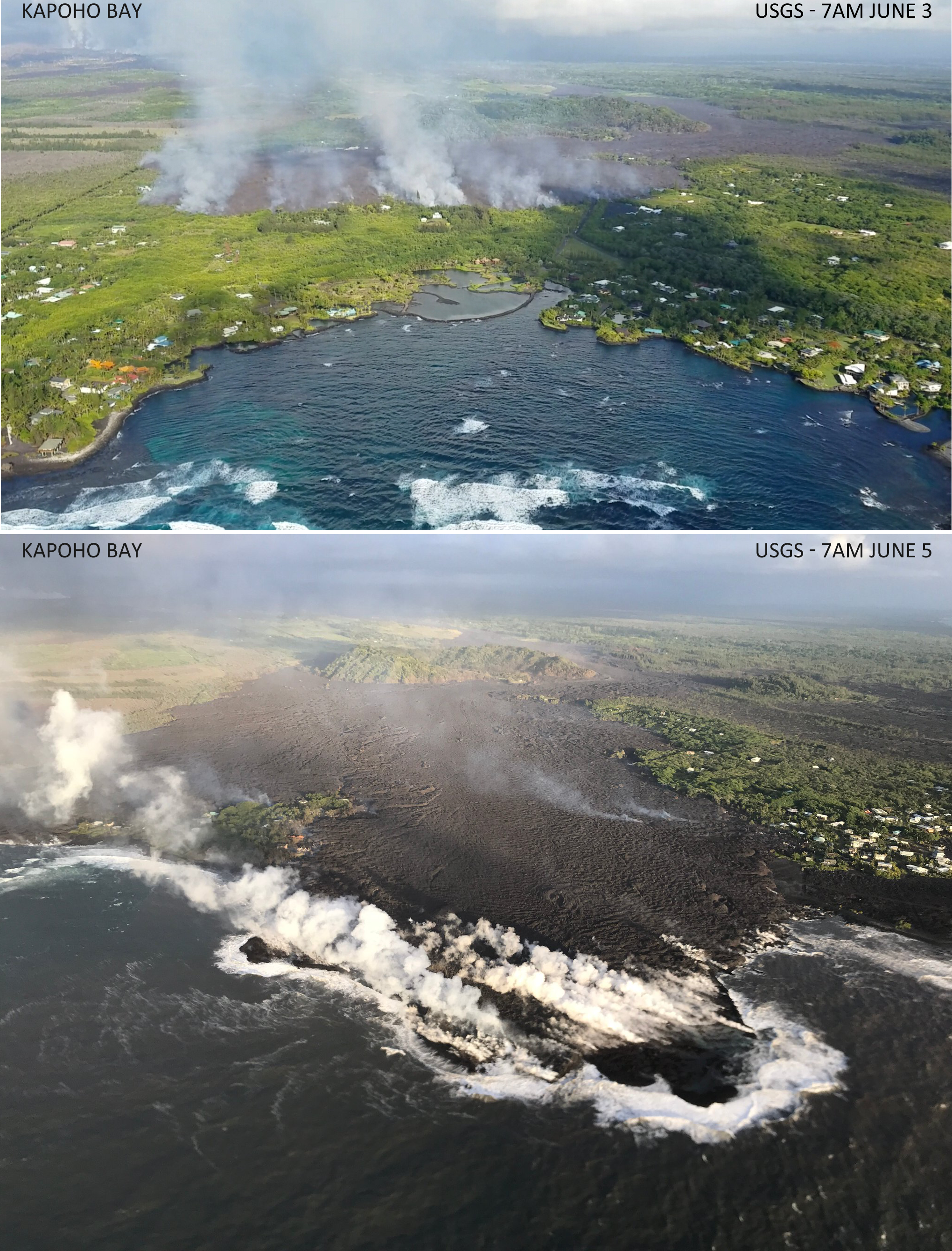
Lava reached Kapoho Bay on Saturday night, around 10:30. By Tuesday morning, it was Kapoho Point. There were hundreds of homes here, plus farms, tidepools, and marine life.
There was another small predawn ash explosion up at Kilauea’s summit, where we can now watch the changes to Halema’uma’u Crater (see below). HI Civil Defense, the Dept. of Health and EPA have set up a new network of sensors to monitor and report air quality in realtime, which should help the rest of the island.
But Vacationland and Kapoho Beach Lots have now followed the 1960 village of Kapoho into memory.
Of course, that’s not the whole story for today. There’s new images and videos, USGS updates and info, articles on the eruption’s impact from local Hawaiian news outlets, and eyewitness reports and reactions on social media. So here’s the usual daily roundup of Kilauea eruption news.
Latest numbers:
Lava coverage ~7.7 square miles, 19.9 square km, 4917 acres.
Janet Snyder, spokesperson from Hawai’i County Mayor’s Office, says at least 117 homes destroyed, but Civil Defense admin Talmadge Magno says probably “a lot more”
Here’s a video clip and two screengrabs to sum up Kilauea’s activity today: a half-mile-wide a’a flow pouring into Kapoho Bay and slowly filling it, while the summit steams weakly after a 5.5 earthquake yesterday.
Screengrabs from the Halema’uma’u and LERZ webcams about 3pm:
Taken from Overlook Vent Wide Angle Webcam, HVO/USGS, Jun 4, 3pm local time. Only light steam.Screengrab from USGS/HVO Lower East Rift Zone webcam, June 4, 3pm. Fissure 8 still fountaining away with broad lava flow issuing to right (northeast), heading down to Kapoho.
ETA: Oh, look. Perfect angle of the sun right now.
Jun 4, 6:20 pm – Nice webcam image from HVO.
Additional info from HVO morning status report: “Local videographers reported that lava entered the ocean at Kapoho Bay at about 10:30 PM HST on June 3. […] A lava breakout is also occurring upslope [north] of the Kapoho cone cinder pit, with active flows about 330 yards southeast of the intersection of Railroad Avenue and Cinder Road.. […]Following the small [M5.5] explosion at about 3:50 PM HST on June 3, earthquake activity at the summit has been low. Inward slumping of the rim and walls of Halema`uma`u continues in response to persistent subsidence. ”
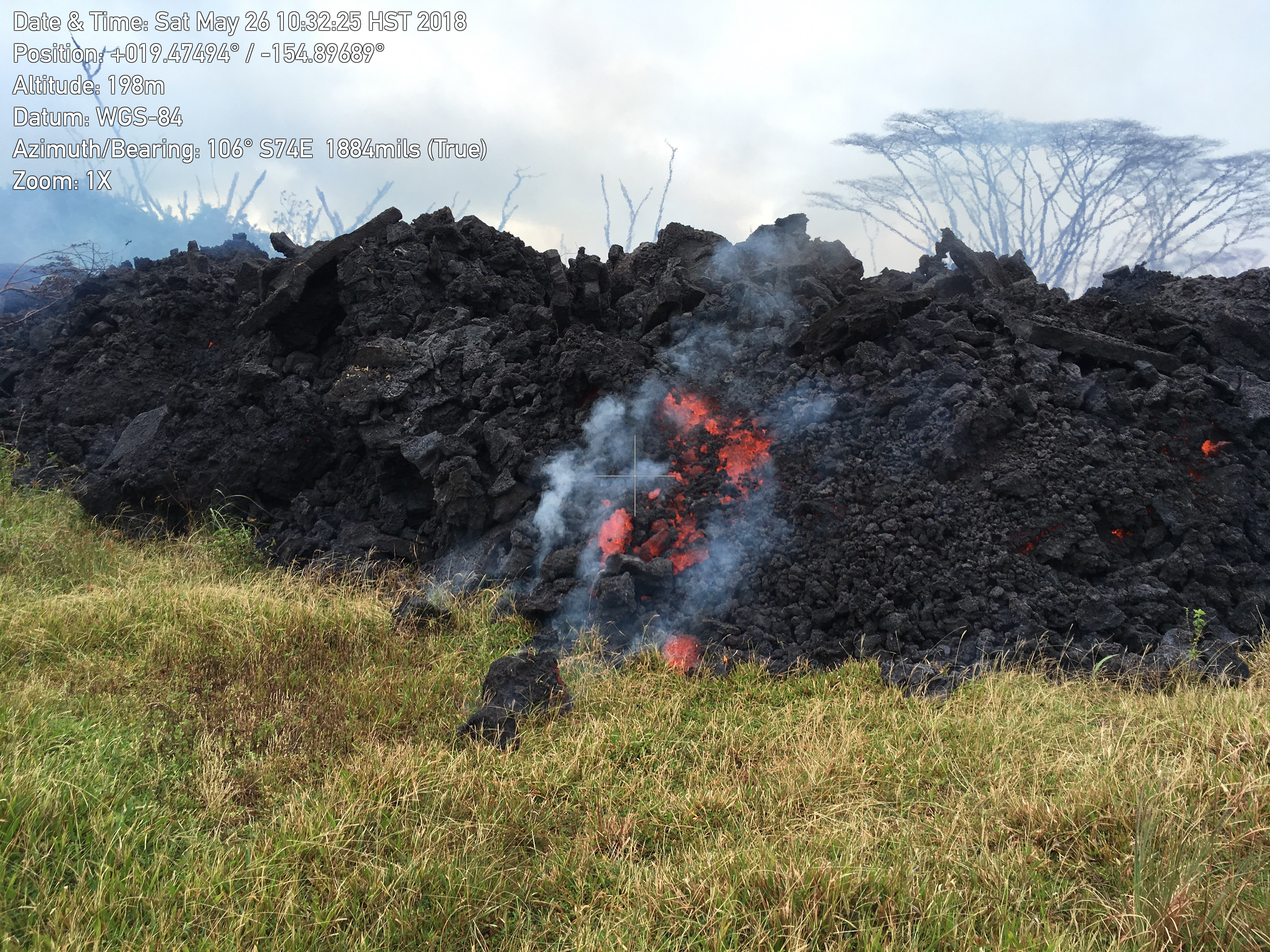
While Kilauea claims homes, possessions, and places people loved— and animals, sadly— it’s a relatively benign volcano (as long asit remains in its lava-gushing“effusive phase”). Its “ballistic rocks” can’t fly much farther than half a mile. Ash and vog hamper quality of life, but aren’t instantly deadly. Its lava moves slowly enough for people to escape. Lava creates new land while it destroys, and it breaks down eventually into fertile soil. While it’s destructive, it’s also beautiful:
This is a "waterfall" of lava pouring into Green Lake that is inside the Kapoho Crater on Green Mountain. The lake…
That’s the life’s blood of a shield volcano like Kilauea. But there’s another kind of volcano I’ve mentioned before: stratovolcanoes like Krakatoa and Mount St. Helens. Their silica-rich, stiff, sticky lava piles up into steep mountains that can bottle up tremendous pressure before letting go. I’m afraid that’s probably what happened in Guatemala today.
Careless news media (even the BBC!) are claiming that a river of lava from volcan del Fuego killed over 20 people and injured dozens more. But all the videos I saw (apart from videos of Leilani Estates passed off as Guatemala) show pyroclastic flows:
Please spare some compassionate thoughts for the Guatemalans caught in this eruption. Most of them probably thought those gray clouds were just (cooled) ash, like what’s irritating Hawaiians living downwind from Halema’uma’u. (No, Kilauea’s not going to do that.)
Today’s kilauea eruption summary
USGS caption: “Photo from 7AM helicopter overflight, hovering offshore and looking up the flowfront. Nearly all of the front was active and advancing; advance rates were estimated at an average of 250 feet/hour (76 m/hr), and as of 7AM the flow was 500 yards (457 m) from the ocean.” (Full-sized)
As for Kilauea, the main news today was fissure 8’s lava flow making its finall approach to the shore through the Kapoho Beach Lots/Vacationland area.
And as if in response to news media headlines claiming it’s “fallen quiet,” the summit woke up again with a whole popcorn-popper’s worth of earthquakes, including a beefy M5.5 in the afternoon and an ash cloud rising to 8,000 feet.
Here’s my daily digest of Kilauea eruption news, including:
Updates/info from the USGS and other geologists
eruption news from Hawaii Civil Defense
Local news stations covering the eruption and its impact
relevant social media posts by informed eyewitnesses
After several days of anticipation, Fissure 8 arrived at last at Four Corners, the intersection of Highway 132 & 137. That gave local residents more time to retrieve their belongs before access to and from the Kapoho/Vacationland area was cut off.
USGS Caption: Northern edge of the fissure 8 flow front on the night of June 1, as it approached the intersection of Highways 132 and 137, known as “Four Corners.” (Full-sized)
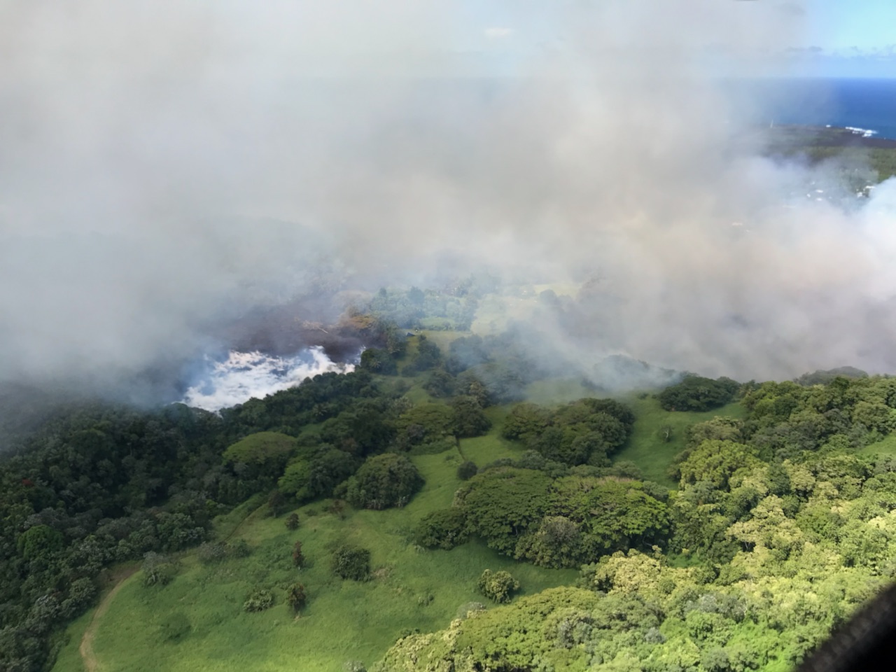
Sadly, while people can evacuate, precious landmarks can’t. Today Green Lake seems to have gone the same way as the Queen’s Bath in Kalapana:
USGS Caption: “As fissure 8 lava flowed into Green Lake, the lake water boiled away, sending a white plume high into the sky—visible from afar between around 11:30 a.m. and 1:30 p.m. HST. This aerial photo, taken a couple of hours later by the Hawai‘i County Fire Department, shows still-steaming lava within Green Lake, located near the intersection of Highways 132 and 137.” (Full-sized)
Kīlauea Message Sat, 02 Jun 2018 20:12:27 HST: F8 flow continues – advancing into Kapoho Crater and through Kapoho Beach Lots. At 10 AM, lava entered Green Lake. By 3PM, HCFD confirmed lake filled & water evaporated. Wide flow front is moving toward ocean.
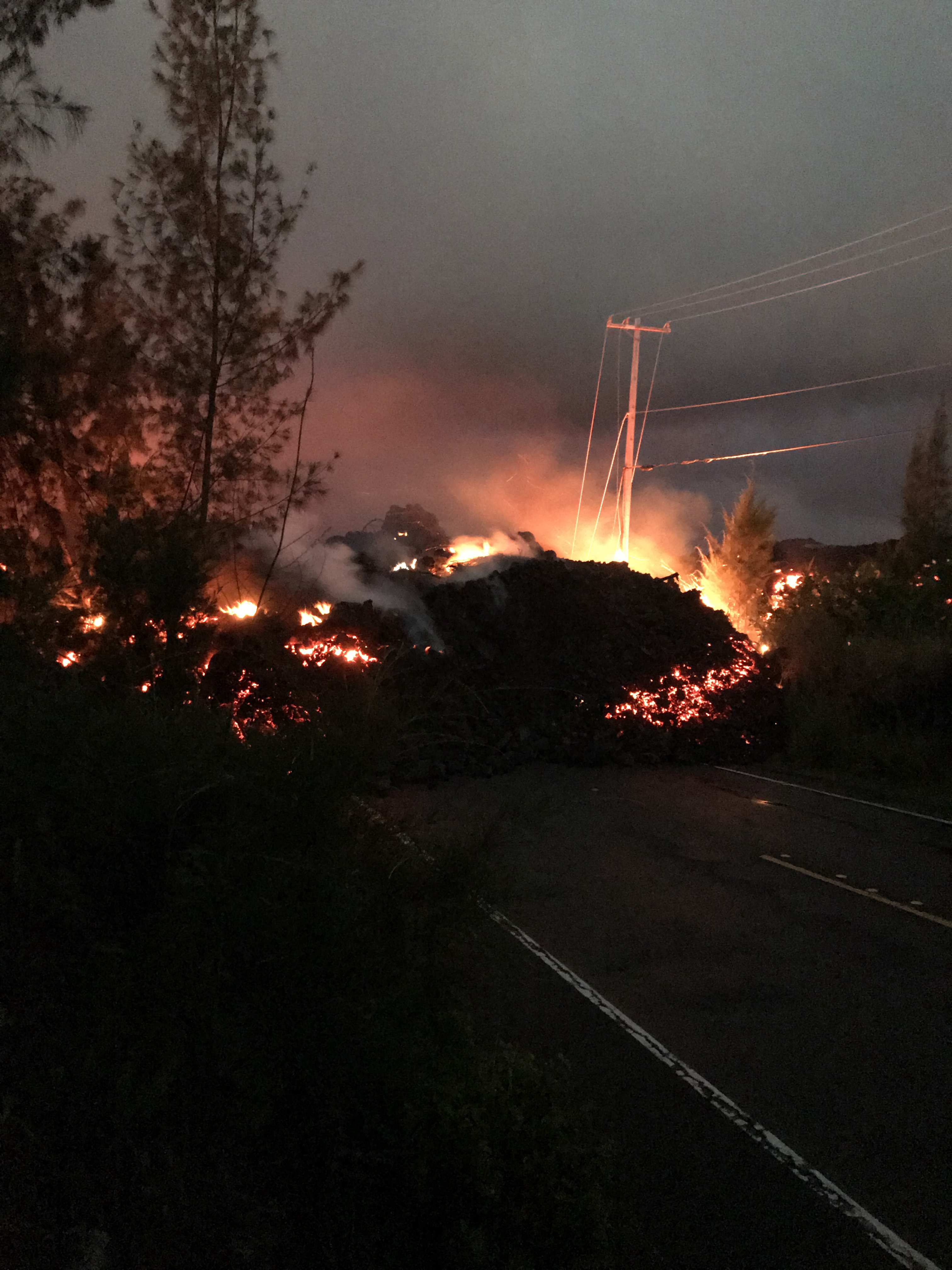
Fissure 8 continues to pump out vast amounts of lava, although it’s slacked off a tad from yesterday’s 260-foot display. One of its fingers burned a building or two at PGV. Other lobes closed in on Kapoho throughout the day, touching Highway 132 again half a mile north of Four Corners at 3:30. Fissure 18, which has been sending a flow east and down towards the ocean, has pretty much stalled apart from some small breakouts. Authorities were ordering Kapoho-area residents out today before lava cuts their only remaining road to the rest of the island.
(That’s a photo of Four Corners, which is the intersection of Hwy 132 & 137. Apparently the lava’s started using 132 as a shortcut again.)
The summit has been steaming and vogging away, but the overlook vent has now been choked with debris falling from its walls. Ash explosions have nearly stopped since the 11am May 30 ash eruption that rose 12,000 ft. Scientists are trying to figure out whether this means the main explosive phase is finished, or whether it’s going to build up enough pressure to blow out the clog. (That said, the crater has not “fallen quiet,” as many non-Hawaiian news stations claimed today. According to @NWSHonolulu, there was a minor “burp” of ash just after 1:30pm.)
A relatively clear day, May 31, finally allowed the USGS to get good, detailed drone footage of changes at the summit.
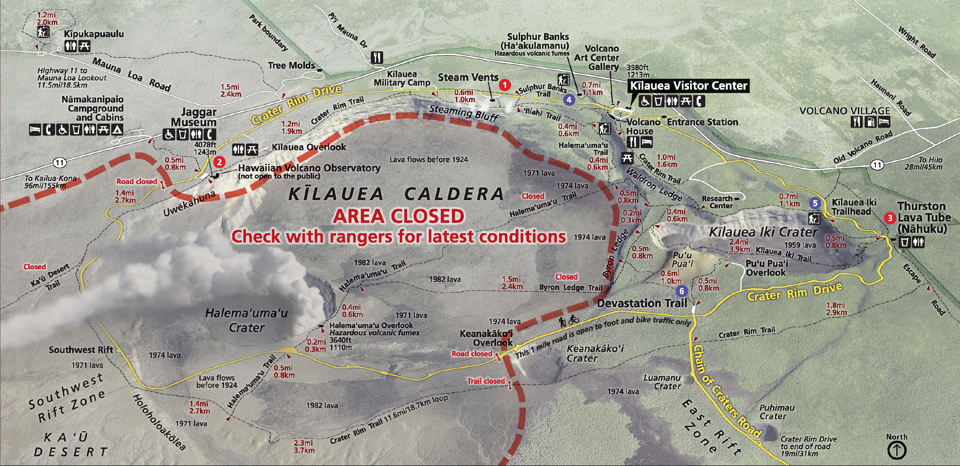
To orient you on the crater-within-a-crater-within-a-crater (Park Map):
Kilauea Caldera is the megacrater, 2×3 miles across, on whose cliff walls are perched the Hawaiian Volcano Observatory, Kilauea Visitor Center and Volcano House.
Halema’uma’u is a crater on the floor of Kilauea Caldera, about 2500 x 2900 feet. It held a lava lake in the 1800s, but drained and exploded in 1924, after which it was quiet for most of the 20th century.
The Overlook Vent was a crater on the floor of Halema’uma’u containing a lava lake from 2008 until May 2018. It drained and has been exploding with steam and ash since the beginning of May. Rockfalls from its sides have enlarged it:
changes at kilauea’s summit, May 2018
May 5-29, USGS animation using radar data from Italian Space Agency’s Cosmo-SkyMed satellite:
May 23-31, new radar imagery shows more recent changes. The USGS caption notes that not only has the overlook vent widened, but also Halema’uma’u Crater:
USGS Animation of recent changes at Kilauea’s summit, radar images taken by Italian Space Agency’s Cosmo-Skymed satellite.
Below, a compilation of video footage of Halema’umau and its lava lake in August 2016. Go to timestamp 2:10 for a good view of Halema’uma’u Crater with the Overlook Vent’s lava lake inside. Compare that with the May 31 video above. The black area is lava that overflowed onto the floor of Halema’uma’u when the lake’s level was high.
Note: the “Overlook Vent” was named after the old Halema’uma’u Overlook, because that’s the side where the lava lake vent opened in 2008. There used to be a parking lot and viewing area on Halema’uma’u’s crater rim where visitors could look down into it. In 2008, the Overlook area was closed to visitors, because whenever there was a rockfall into the lake it tended to do THIS:
It’s been exactly a month since the first lava started emerging from fissures in Leilani Estates on May 3. And what a month it’s been.
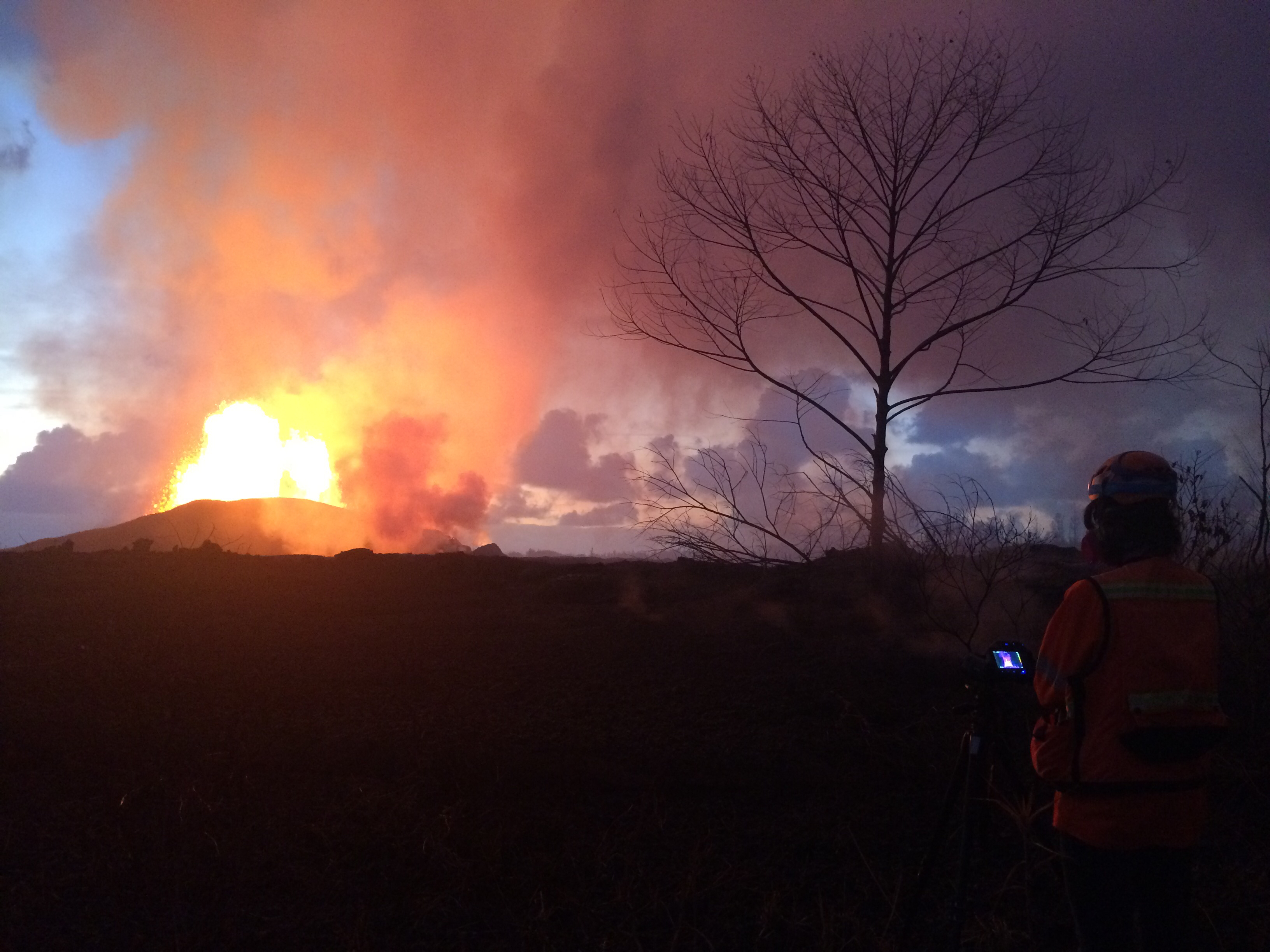
USGS Caption: Crews make visual observations of activity at fissure 8 around 5:30 am HST. Fountain heights this morning continue to reach 70 to 80 m (230 to 260 ft above ground level. The fountaining feeds a lava flow that is moving to the northeast along Highway 132 into the area of Noni Farms Road. Full-sized)
Kīlauea Message Thu, 31 May 2018 14:10:42 HST: As of last night, area covered by lava from Kīlauea LERZ eruption equal to 5.5 square miles (3534 acres). Highest temperature from F8 measured today, 2039 F (1115 C).
Meanwhile, Pu’u O’o on Kilauea’s shoulder drained and died after a historic 35-year-long eruption. The summit lava lake in Halema’uma’u Crater followed suit, draining away more gradually but no less dramatically, with rockfalls and earthquakes and clouds of ash rising as high as 15,000 feet. Downwind communities are suffering from its ash and vog. The threat of steam explosions sending rocks flying half a mile has forced the closure of Hawaii Volcanoes National Park. That, coupled with jittery tourist cancellations, has struck almost as big a blow to the rest of the Big Island as lava has done to a few square miles of Puna.
The USGS and Hawaii Civil Defense have done a herculean job of monitoring, informing, warning, and moving people out of harm’s way in this fast-moving and complex natural disaster. And locals are rallying as best they can to support one another.
Today’s Eruption Summary
Kilauea’s still pulling some (alas, not all) of its punches. Early Wednesday morning, Fissure 8’s lava flow was surging towards Four Corners in sprints up to 600 yards an hour, causing emergency officials to go door to door ordering emergency evacuations. Luckily, it’s slowed, although it’s still inching towards the last remaining road in and out of Puna. People have had two precious days to go back and rescue pets and possessions before the lava cuts them off.
Meanwhile, the summit today was steaming with minor ash explosions. The USGS just released another drone survey of Halema’uma’u filmed May 26:
See caption on USGS website, and compare with drone footage of May 21.
Normally I tuck the USGS media conference call into my digest for the day, but my notes are so long I decided to put this in its own post.
Summary: Eruption is continuing with no signs of stopping. Wendy Stovall gives all kinds of geeky tidbits about temperatures, heights, where the magma is coming from, plumbing system of Kilauea. She emphasizes that Kilauea receives a “continuous supply of magma from the deep mantle” thanks to its mantle plume. Scientists are starting to discuss calling this a new eruption, but their focus right now is on collecting data and getting info to Civil Defense.
Full notes (sorry they’re a little rough, but you’ve got the gist) below cut:


