May 30: Pele Makes A Run For Four Corners

Today’s Eruption Summary

In fact, the current lava eruptions in Puna are as hot as Hawaii’s lava will ever get. “It can’t get hotter than where we are,” Stovall added. “We are pretty much tapping mantle temperatures right now.”

Honolulu Civil Beat

USGS Photo – Caption: “Lava flow erupted from fissure 8, photographed during HVO’s early morning overflight today. The lava channel was estimated to be about 100 feet wide.” (Full-sized)

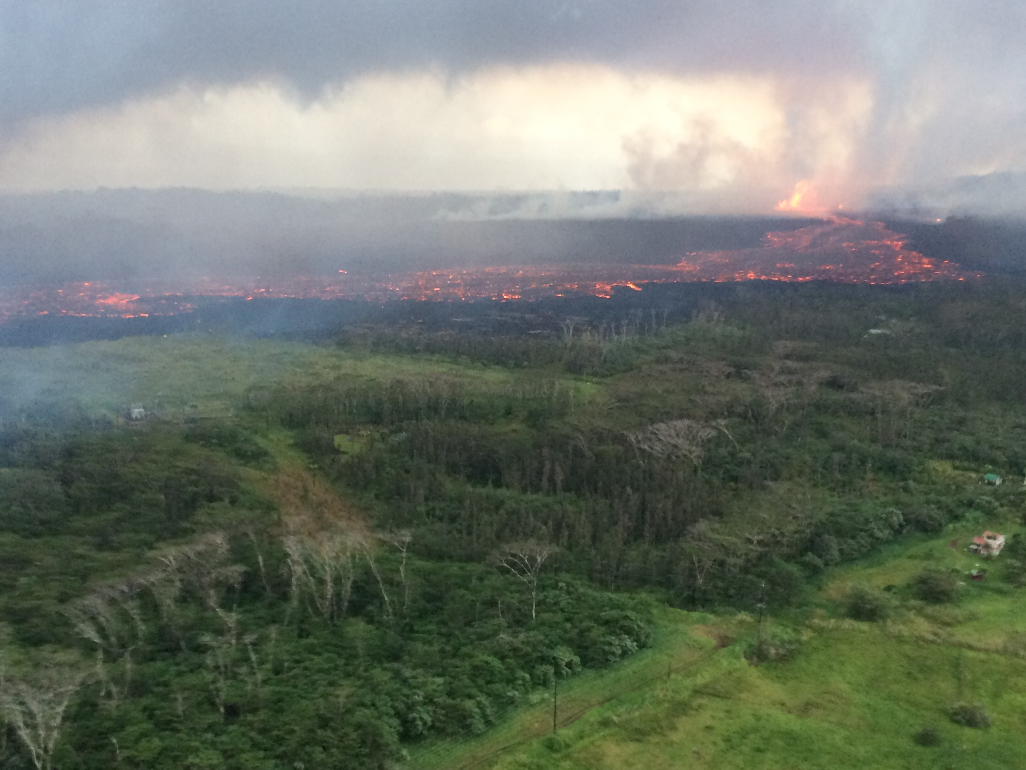
Fissure 8 is beauty & the beast. Since Saturday it’s been pumping out a huge volume of lava, creating pahoehoe and even a’a flows that occasionally surge up to ~600yards/hour. Yesterday its main flow headed NE, skirted the geothermal plant, crossed and followed Hwy 132 for a while, and then started downslope past Noni Farms towards Four Corners, threatening to cut off Kapoho and Lower Puna.

Amazing overflight photo of Fissure 8 and its lava flow taken on May 29 by Hawaii Civil Defense. (Full-sized)

In the early morning hours, officials went door-to-door in the Kapoho area ordering emergency evacuations.  Newly-paved Beach Rd was pressed into service as a one-way evacuation route from Four Corners to Hawaiian Beaches. But it’s a race against time, as the lava is headed for that very road.

[ETA: Mick Kalber’s flyover. He’s always got notes on the video’s page.]

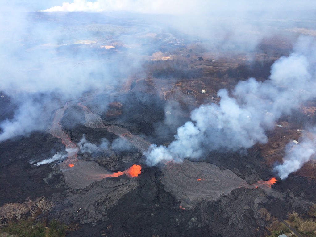
I saw no PGV news today, which is good. The summit produced yet more ash & earthquakes, one a pretty good thump (Mag 5.3 at 10:57am, no tsunami). Meanwhile, Fissure 18 is sending a channelized flow towards Hwy 137, just a little east of last week’s flows to the ocean:
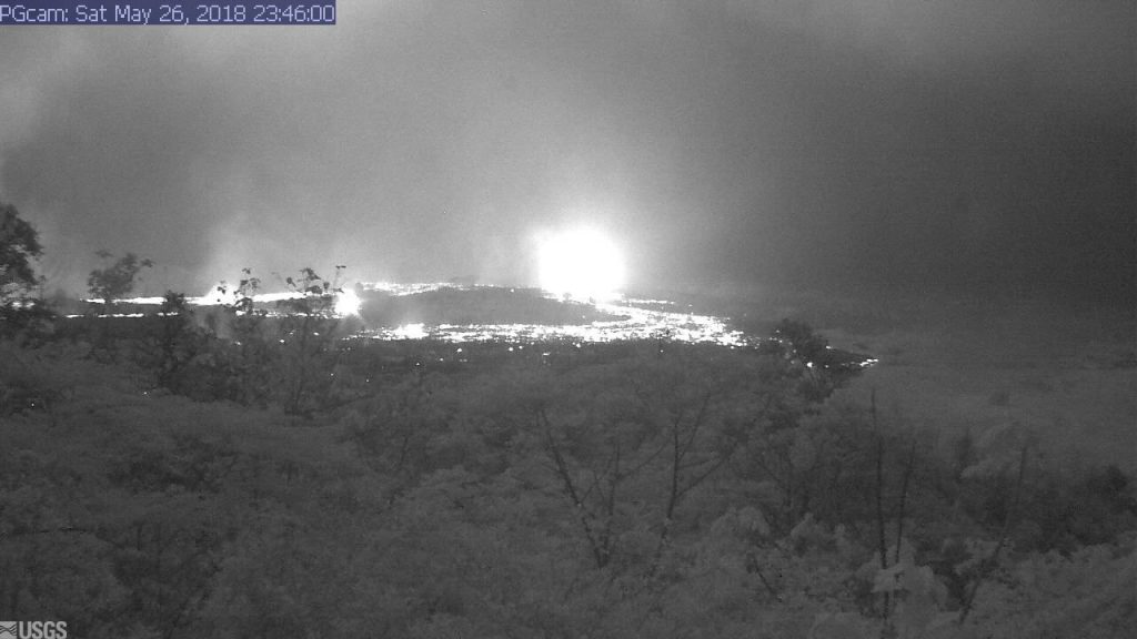
TUESDAY EVENING IN PAHOA: USGS BRIEFING

Continue reading May 30: Pele Makes A Run For Four Corners

May 29: Day of Reckoning for PGV (and LavaCam)

I’m wiped after following events of the last two nights from 3 timezones later— nothing compared to the exhaustion of Puna residents or HVO geologists, I’m sure— so today’s post is going to be less meticulous.

Today’s Eruption Summary

Sunday and Monday nights, the new monster Fissure 8 tossed fragments high in the air that carried onto houses over a mile away: clinkerly bubbly volcanic cinders (also called tephra), fine glass strands called Pele’s hair, and small volcanic glass droplets called Pele’s tears. Authorities warned people to be careful of Pele’s hair, which is basically natural fiberglass, as it can cause skin and eye irritation.

Another spate of vigorous 200-foot-tall fountaining from Fissure 8 last night sent a second fast-moving flow northeast along the edge of Sunday night’s flow, triggering more emergency evacuations and (I’m afraid, haven’t seen any tally) the loss of more homes. At 6:30am Tuesday, civil defense closed Highway 132 near the geothermal plant in anticipation that lava would reach it today. At 3:30PM, the lava did indeed begin to encroach on 132, leaving only one other road still open to Lower Puna.

Before crossing 132, 8’s northeast lava flow marched towards and into PGV property, cut off plant’s main access road, prompted staff to evacuate, and began to burn and cover over buildings and equipment. I believe sensors have been left to monitor the wells. I’m guessing a’a is a better thing to get covered by: it’s somewhat cooler than pahoehoe, and it can’t seep into cracks.

At the summit, ash eruptions and earthquakes continue. A 2am ash eruption was 15,000 feet tall, followed by a 4.5 earthquake. Light winds are sending the ash nw, towards Volcano and Pahala. There’s a meeting at Pahala tonight to discuss vog and ashfall, which is going to be an ongoing problem for these communities however long this eruptive phase lasts. 

At night, the webcam is showing incandescent blocks flung out onto the rim of Halema’uma’u Crater, but we don’t know how big or how many because it’s unsafe for scientists to approach. However, they’re installing a new thermal cam soon that should help them see the blocks. (Source: 11AM conference call) 

Time for today’s roundup of USGS bulletins and info, relevant posts by geologists, images and videos, local news reports, and the eruption through the eyes of social media.

Continue reading May 29: Day of Reckoning for PGV (and LavaCam)

May 28: Rivers of Fire, Lava Livestream is back

Today’s Eruption Summary

About 7PM yesterday, a large pahoehoe flow suddenly burst out and went galloping through Leilani Estates. Civil Defense called for emergency evacuations. Firefighters had to guide one person to safety (with assistance of drone team tracking lava) when the flow covered his drivewayUSGS and Civil Defense reported that vigorous fountains 7 and especially 8 were responsible for the outbreak: fountaining 150-200 feet high, they built up a spatter rampart 100 feet tall and fueled a monster pahoehoe 20-40 feet thick. Speed augmented by the perched lava pond breaching (dam gave way, basically).

You can get a sense of last night’s outbreak from this timelapse of the Lower East Rift Zone webcam over the past few days.

The flows from yesterday slowed and stopped this morning. Most of the day’s activity was fairly subdued, with “only a minor ooze of residual lava” making it down to the ocean. But this evening, fissure 8 and other vents went into overdrive again, pouring out rivers of lava and prompting more emergency evacuations (Civil Defense notice) (HVO/USGS Alert).

Lava livestream

Honolulu Civil Beat is back to let us watch nature’s pyrotechnics from about 2km away and a crucial 200 feet up.

It’s mesmerizing to watch, but a sobering sight as well, knowing homes downstream are burning and some people are in danger. 

I can’t watch now; I have a post to write. Where was I? Continue reading May 28: Rivers of Fire, Lava Livestream is back

May 27: First Well Covered; Emergency Evacuations From Fast-Moving Lava

The dramatic light show I noticed on the East Rift Zone webcam last night was probably from fissure 7, featured on today’s Mick Kalber helicopter flyover (warning: noisy).


(Blog post: Mick Kalber’s observations from this flight)

Most of today’s news is about marauding lava flows in the Lower East Rift Zone, but the ESA just posted another satellite radar image of changes at Kilauea’s summit:


[EDIT] Things got a little TOO exciting this evening, and I kept having to update this post…

Continue reading May 27: First Well Covered; Emergency Evacuations From Fast-Moving Lava

May 27: Lava reaches PGV property

I see from Hawaii NWS that small summit ash explosions continue, probably dusting downwind communities. But events down at Leilani Estates have dominated the news today.

To recap: after much foot dragging and a history of safety violations, Puna Geothermal Venture has not won the confidence of many Puna residents.

But Hawaii Civil Defense also confirms the now-quenched wells are “essentially safe.” The concern is that toxic hydrogen sulfide could be released if lava breaches a geothermal well. PGV worked to secure these wells last week, but they’re flying in 200,000 pounds of clay from California today to contain explosions, so…we’ll see.

#LeilaniEstatesEruption #KilaueaVolcano UPDATE (May 27 at 10:15 AM): Hawaiʻi County Civil Defense agency officials cannot tell me what would trigger a mandatory mass evacuation of the area surrounding Puna Geothermal Venture — despite the fact lava has reached the 40 acres of their operational plant site and is approaching the well field. Civil Defense officials say no wells have been impacted and a team is working to prevent threats from developing. At this time, no hydrogen sulfide has been detected. I asked Civil Defense: “What would trigger a mass mandatory evacuation of the area?” We were sent this response: “If it becomes necessary for public safety. At that point, we will alert the public.” We followed up with these questions: “Can you explain what government officials have determined this threshold to be? It’s obviously not lava inundating PGV property, so can you clarify?” We were told there was no additional information beyond their statement. We have since reached out to the Governor’s office for assistance and have confirmed Gov. David Ige will be returning to Puna this afternoon. At last check at 7:30 AM, PGV spokesperson Mike Kaleikini said the nearest well was about 130 feet away from the lava flow front. “All of the production wells nearest to the lava flow are plugged and shut in. According to HVO scientists, movement is currently stalled. As long as conditions are safe, we will have personnel on site. Primary concern is sulfur dioxide from the eruption and lava coming on site. We monitor for hydrogen sulfide and sulfur dioxide on a continuous basis. There are no hydrogen sulfide emissions from PGV wells,” said Kaleikini. PGV officials maintain they believe they have mitigated the threat of an uncontrolled release of hydrogen sulfide if lava inundates their property and makes contact with their wells. However, PGV officials have conceded they don’t know if hydrogen sulfide is the only possible hazard the community could face if lava interacts with their wells. Stay tuned to @HawaiiNewsNow (Video: Civil Defense)

A post shared by Mileka Lincoln (@milekalincoln) on

UPDATE:  Half hour Press Conference with Gov. David Ige and Tom Travis of Hawaii Emergency Management. The gist: the wells are secure, and they’re being monitored.

Lava covered one well this evening. So far, so good:

Video Clips: Pāhoehoe vs A’a (What’s the Difference?)

If you’ve followed this blog at all, you’ve come across the terms “pāhoehoe” and “a’a.” They’re Hawaiian words borrowed by volcanologists as technical terms for different types of lava. How can you tell which is which?

When I visited in 1986, the joke was that “a’a” is the noise you make when you walk on it, because it’s prickly, and “pāhoehoe” is the smooth stuff. But that’s oversimplified, and it confused me. Some of the old pāhoehoe flows we hiked on near Mauna Ulu seemed pretty bumpy to me.

Pāhoehoe lava is runny, faster-moving, and often described as “ropey.” It’s pretty obvious when it’s spilling into a crater or running swiftly in a river. Sometimes it has ripple marks. At other times, the leading edge slows down and turns blobby. Here’s an excellent USGS video of a pahoehoe front in night and day, May 24-25:

Pāhoehoe moves forward by inflating lobes of lava with fresh new lava from within.

Then there’s a’a lava: a crumbly, chunky mass of what looks like a heap of rocks and gravel and dirt, except it’s red-hot under the outer skin. It moves like a horizontal landslide in slow motion, bulldozing everything in its path:

It advances mostly by chunks tumbling forward off the front.

A’a is usually quite slow. You can outwalk it. In fact, you’d usually have time to pack a small suitcase if it showed up at the end of your street. Whereas when pāhoehoe flows downhill or becomes “channelized,” making itself a smooth chute, you can’t outrun it:

Both kind of lava make crinkly noises, but I think of a’a as “clinkity clankity” lava, whereas pāhoehoe tends to slither.

So now you’ll know how to explain it the next time someone asks, “What’s the difference between pāhoehoe and a’a?”

May 26: Lava Turns Towards PGV

Puna residents watch with a sinking feeling of “I told you so” as a ponderous a’a flow crossed Pahoa Pohoiki Road slightly north of the geothermal plant, inching towards it. Officials think they’ve got the wells quenched  (I notice they quietly dropped the idea of plugging them), and that they’re safe.

Hawaii County photo looking south across Pohoiki Road, geothermal plant bottom left. Photo not timestamped but probably around noon. “Fissures 7 and 21 are feeding an ‘a’ā flow that has advanced to the northeast and this afternoon crossed Pahoa Pohoiki Road onto PGV property, USGS reported.”

Meanwhile, Fissure 7 is causing trouble in all directions; its lava pond has sent another flow “cascading into Pawaii crater” (6:15pm).  Looking at the map, I’m betting that crater is an old vent from a previous fissure eruption just like this one. In addition to fluid/runny pahoehoe flows, some of the longer flows are a’a.

The summit has also been busy today, with three ash explosions reaching the ~10,000 foot height between midnight and dawn, and some reaching “as high as 12-13K‘ [above sea level]” this morning. Reminder: Kilauea is 4009 feet above sea level (asl).

Moving on. I’ve gotten in the habit of checking the Lower East Rift Zone webcam last thing before I post:

USGS webcam of LERZ. Grabbed just before midnight, May 26. Is that a lava flow coming towards the camera?

Next image on the LERZ webcam.

I do believe it is. Has that lava pond broken loose?

Lava tally as of Saturday morning: 41 houses, 82 structures total. A further 37 homes isolated by lava crossing roads. Lava has covered 3.7 square miles/2372 acres so far.

Here’s the usual roundup of the day’s eruption news, astonishing views, and geeky info by geologists:

Continue reading May 26: Lava Turns Towards PGV

May 26: Good Morning, Hawai’i

Strange that something so disruptive can be so beautiful.

Hawaii Volcano Observatory Alert: Saturday at 5AM, the summit crater let off a series of explosions at 5AM sending up an ash cloud 11,000 feet that lingered for 25 minutes. Lighter winds may keep ashfall from today’s explosions mostly within the park, giving downwind communities a respite. [Edit: No such luck. Taller ash explosions today had more range.]

HVO webcam caught a nice glimpse of plume by moonlight (“exit” sign of observatory reflected in lens):

(Camera is picking up a few lights from observatory; note “Exit” sign.)

Sadly, it was not so tranquil-looking down in Leilani Estates, 25 miles away:

May 25: End of the Road for Leilani Estates?

It looks like the coup de grace for Leilani Estates, or at least its eastern part.

USG Photo, May 25, noon overflight. Fissures 6 (left) and 13 (right) send lava flows south that join and flow down to ocean (white laze plume in distance). Note metal roof(?) embedded in lava at lower left. [Full-sized]
Three weeks ago Leilani’s streets were lacerated by fissures, battered by lava spattering from cracks, and blocked off by ponderous flows that seldom traveled far from their source. But that was a slow-motion disaster. Most fissures were active only a few hours. While a few unlucky residents lost homes in the first wave, most were able to return and collect vital possessions, or even risked dangerous fumes to stay.

Last week, the main lava activity shifted east, downrift, overrunning smaller Lanipuna Gardens, threatening the PGV geothermal plant, and inundating fields and woods where homes were more scattered.  “Hotter, fresher” magma arrived last Thursday with a roar, spurting in several-hundred foot fountains and flooding forests with rivers of fast-moving pahoehoe lava. On Saturday night, these channels reached the ocean.

It was only a reprieve. A few days ago, the fissures that had given Leilani grief began reactivating. The group of fountains monitored by HCB’s livestream began to subside as uprift vents pilfered their magma supply.  Leilani’s reinvigorated vents poured out so much lava they created a pond, as well as sending new flows down to the sea. And through people’s houses:

Today, more streets were buried. Firefighters went door-to-door urging the last holdouts to flee before lava reaches them. Even parts of lower Puna not yet menaced by lava were ordered to leave before their remaining escape routes are cut off. Just in case, authorities have sent in the Marines.

82 structures lost. A two mile stretch of fissures in a residential area is pouring out an astonishing 40-60 cubit feet per second. And yet only 3.4 square miles have been covered by lava in this eruption, on an island of over 4000 square miles. But that doesn’t make it any easier for those affected.

Below, a roundup of Friday’s images, videos, USGS news, and reports from local news stations.

Continue reading May 25: End of the Road for Leilani Estates?