Fissure 8’s eight-mile lava river and the summit’s daily explosion have followed their usual pattern of the past two weeks. However, volcanic gas emissions at the Lower East Rift Zone doubled on Saturday compared to the past week, while SO2 emissions from Halema’uma’u are about half what they were before this current eruption started.
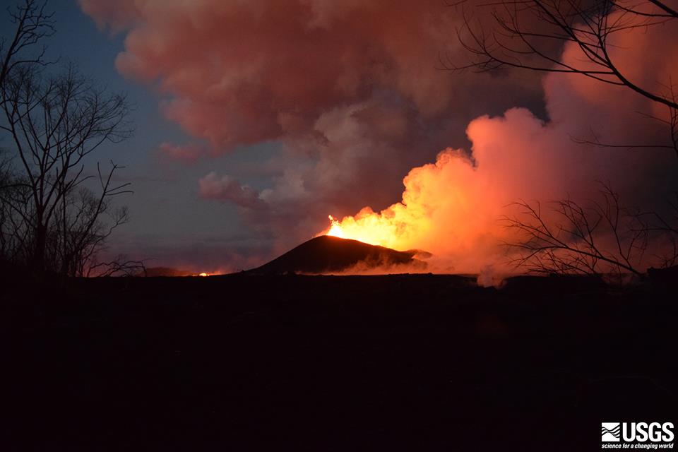
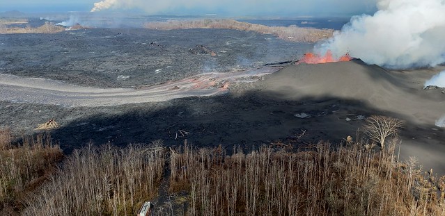
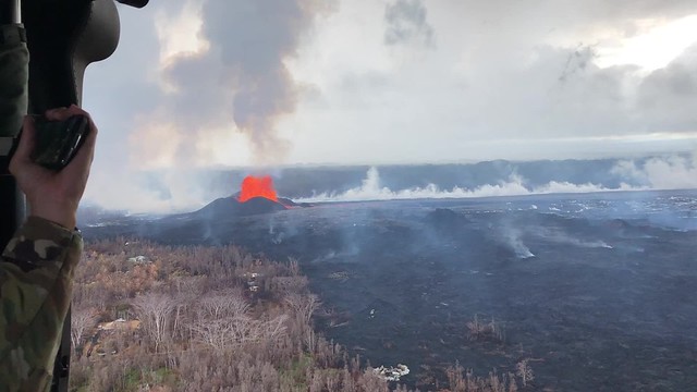
USGS: “The fissure 8 cone and lava fountaining viewed at 8PM HST on June 9 from a location on Kupono Street. The incandescence to the left is lava in the active channel.” BELOW: June 10 Hawaii Fire Department Overflight, ocean entry plume in far distance.
Are those two facts linked? I dunno. I’ll be interested to hear if/when lava samples collected from the Fissure 8 flow start to show signs they came down from the summit instead of Pu’u O’o.
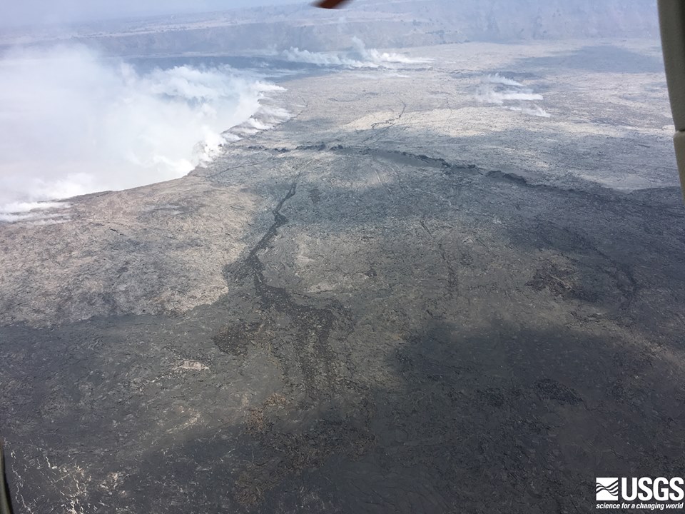
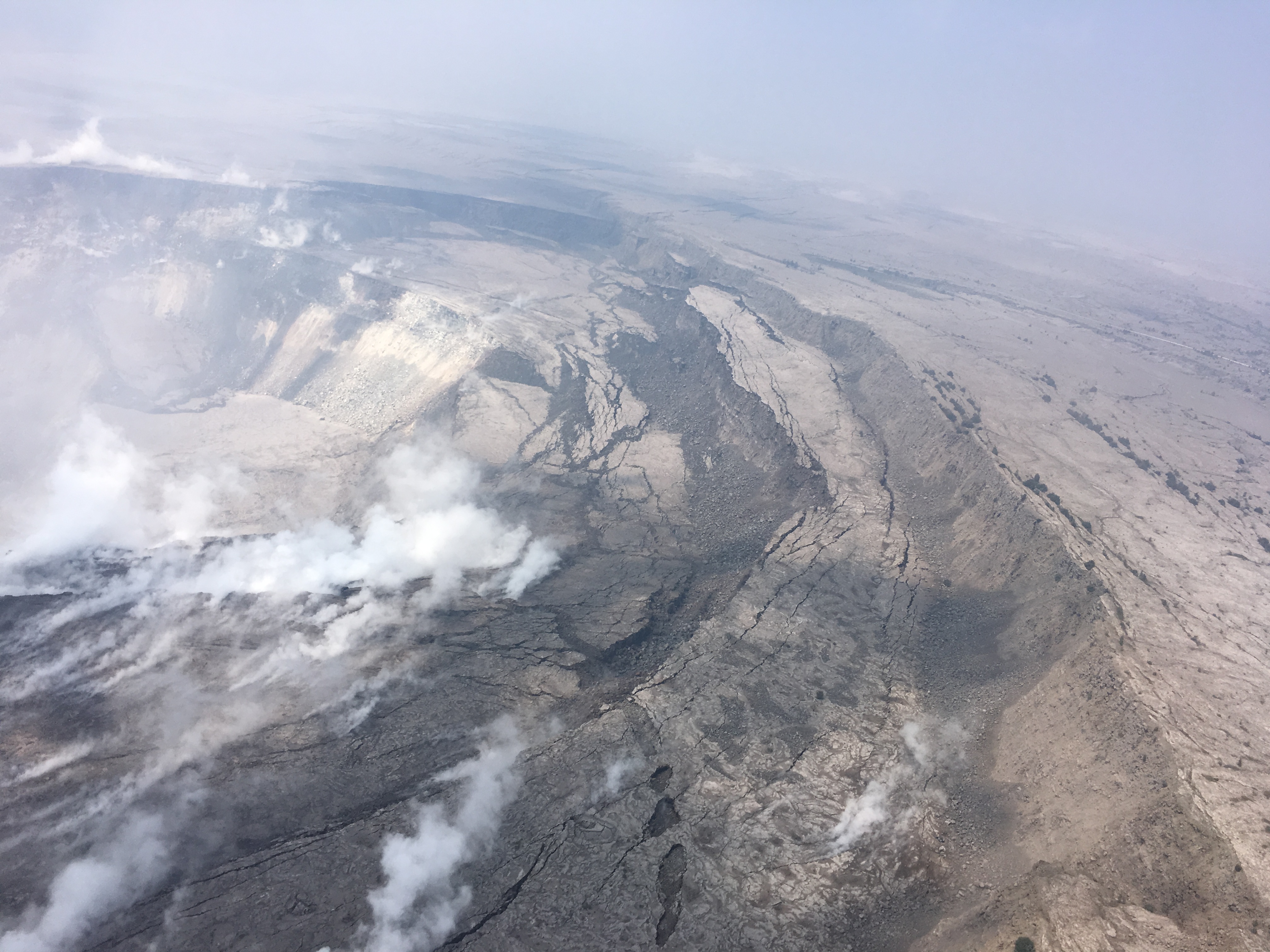
USGS: “The northern rim of Halema’uma’u Crater at Kilauea’s summit on June 9, from the noon helicopter overflight. The floor of the Kilauea Caldera is showing prominent cracking from the ongoing subsidence, and the steaming cracks in the background have been observed for several days now.”
Before-and-After Halema’uma’u 2017 vs 2018
I found a July 2017 screencap from HVO’s panorama webcam, so here’s an animation fading from it to today’s view. Check out the full-sized animation; you can really see how much Halema’uma’u has enlarged.
Be warned, there’s some sad news, especially in the social media section at the end. This is a natural disaster, and it’s hard, even if it provides some amazing visuals and fascinating science as compensation. But they can’t make up for what’s lost.
One gets the sense that crisis mode is giving way to some sort of new normal, as it did during the decades of the Pu’u O’o eruption. Not that one can ever call this normal:
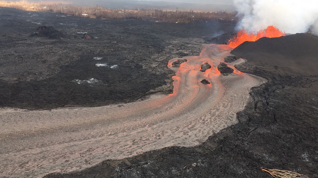
USGS: “Fissure 8 and lava channel in the lower East Rift Zone of Kīlauea Volcano during this afternoon’s overflight, with no apparent slowing in the eruption rate. The lava channel remained incandescent all the way around Kapoho Crater before entering the ocean.” (Full-sized)
Still, public meetings are no longer dominated by talk about lava, fissures, and SO2 so much as how to collect on insurance and find housing. The USGS has dropped weekend video briefings to give its staff a much-needed break (alerts/info are still posted on the HVO website). Hawaiian news outlets are reverting to a more typical news cycle, with only 1-2 new Kilauea updates a day.
At the summit, steam/ash explosions continue their recent pattern. Today’s explosion registered as M5.2 at 4:48am, shaking the village of Volcano; it was felt as far away as Hilo. (Local radar is still out, but the ash cloud was small, less than 10,000 feet, since satellites can spot bigger ones).
Halema’uma’u is looking very ragged around the edges:
USGS: “Cracking and slumping of the Halema‘uma‘u crater walls are clearly evident in this aerial view captured during HVO’s overflight of Kīlauea’s summit this morning. Steam plumes have been rising from within the crater, as well as from cracks adjacent to the crater.” (Full-sized)
In the Lower East Rift Zone, Fissure 8’s fountain has tapered off slightly, down to 130-160ft with occasional bursts up to 200ft, but its lava river is still going strong. As of 6:30am, the new lava delta at Kapoho had grown to 200 acres. An elevated section of the flow near Lava Tree State Park caused some concern this afternoon when it started overflowing its levee, but it settled back into the main channel without a major breakout.
I’m running late tonight, so here’s a somewhat abbreviated weekend edition of USGS info, eruption news, images and videos, including timelapses of the summit and fissure 8 for the past week:
These days, it seems like every time we think the eruption’s settled into a kind of equilibrium, it ramps up its activity in one way or another, so I’m sure this headline will be obsolete by morning.
But for today, Kilauea’s new status quo still holds: increasing numbers of summit earthquakes leading up to an ash/gas explosion (yesterday’s was 5.6); fissure 8 pouring out a river of lava adding new real estates to former Kapoho Bay. Updated count in homes lost jumps to ~600, most during the past week when 8’s wide flow covered shore communities.
“Lava fountaining at Fissure 8 fluctuated with heights varying between 190 and 215 feet. This activity is feeding a lava channel flowing east to the ocean entry in the Kapoho Bay area. The noon overflight found that the delta is about 1.2 mi wide in the Vacationland/Waopae area and observed the flow was expanding northward through Kapoho Beachlots. A large area of upwelling offshore suggests the presence of lava flowing on the ocean floor in that area.” —HVO alert June 7, 4:24 HST
Easterly winds tomorrow may blow more vog, particulates, and Pele’s hair over populated areas to the west.
No significant changes; afternoon overflight grounded due to bad weather; summit seismicity climbing, and a small explosion is expected overnight based on patterns of previous events. pic.twitter.com/qVj0nqn4ge
This is something that hasn’t really come up, and I think it’s important to hear: a frank reply from USGS Wendy Stovall and Leslie Gordon during a media conference call about the psychological impact of this eruption on scientists.
Images, more videos, and info (including science segment of this conference call) after the cut.
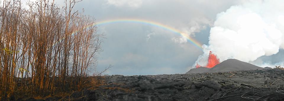
USGS/HVO photo of Fissure 8, spatter cone and rainbow, June 6.
Today’s Eruption Update:
Last night, USGS scientist Steve Brantley explained the current eruption in an informative 10 minute talk. I transcribed it as a separate post, but here’s a rough summary: Magma heading down to the Lower East Rift Zone is causing the summit to deflate. Deflation is causing a pattern of more and more earthquakes over 30-50 hours until the summit releases the strain with an explosion, accompanied by an ash cloud.
Sure enough, there was an M5.6 explosion and 10,000 foot ash cloud at 4:32pm. HVO’s Twitter account had a great impromptu Q&A session about it (see below).
Meanwhile, down in the Lower East Rift Zone, Fissure 8 shows no signs of slowing. It’s wiped out Vacationland and nearly all of Kapoho Beach Lots, and is continuing to create new (crumbly, hazardous) beachfront real estate.
USGS has also been posting some striking imagery today.
Video description: “HVO’s mid-day overflight on June 5 shows ongoing partial collapse of Halema‘uma‘u at the summit of Kīlauea Volcano. To the north of the former visitor Overlook parking area (closed in 2008) is the site of the former lava lake—now a deep hole piled with wall-rock rubble. The western portion of Halema‘uma‘u has moved down and toward the center of the crater as new cracks form on the caldera floor to the west. Kīlauea’s summit continues to subside due to withdrawal of magma towards the volcano’s East Rift Zone.”
They’ve also posted drone footage of Fissure 8 lava flow on June 3. Houses give a sense of scale:
At a public talk in Pahoa, Hawaiian Volcano Observatory Deputy-Scientist-in-Charge Steve Brantley gave a 10-minute talk on the 2018 Kilauea eruption sequence so far.
I was going to summarize it in my June 6 Kilauea daily digest. However, it’s so useful I’ve transcribed it in full below.
The full community meeting is archived here, with Steve Brantley’s presentation starting at 44:30. BigIslandVideoNeed has excerpted it below, but they don’t usually show the slides he was showing. I’m going to be putting those back in, matching or approximating the photos he selected.
Steve Brantley, HVO/USGS: “Good evening and thank you for coming out tonight. […]
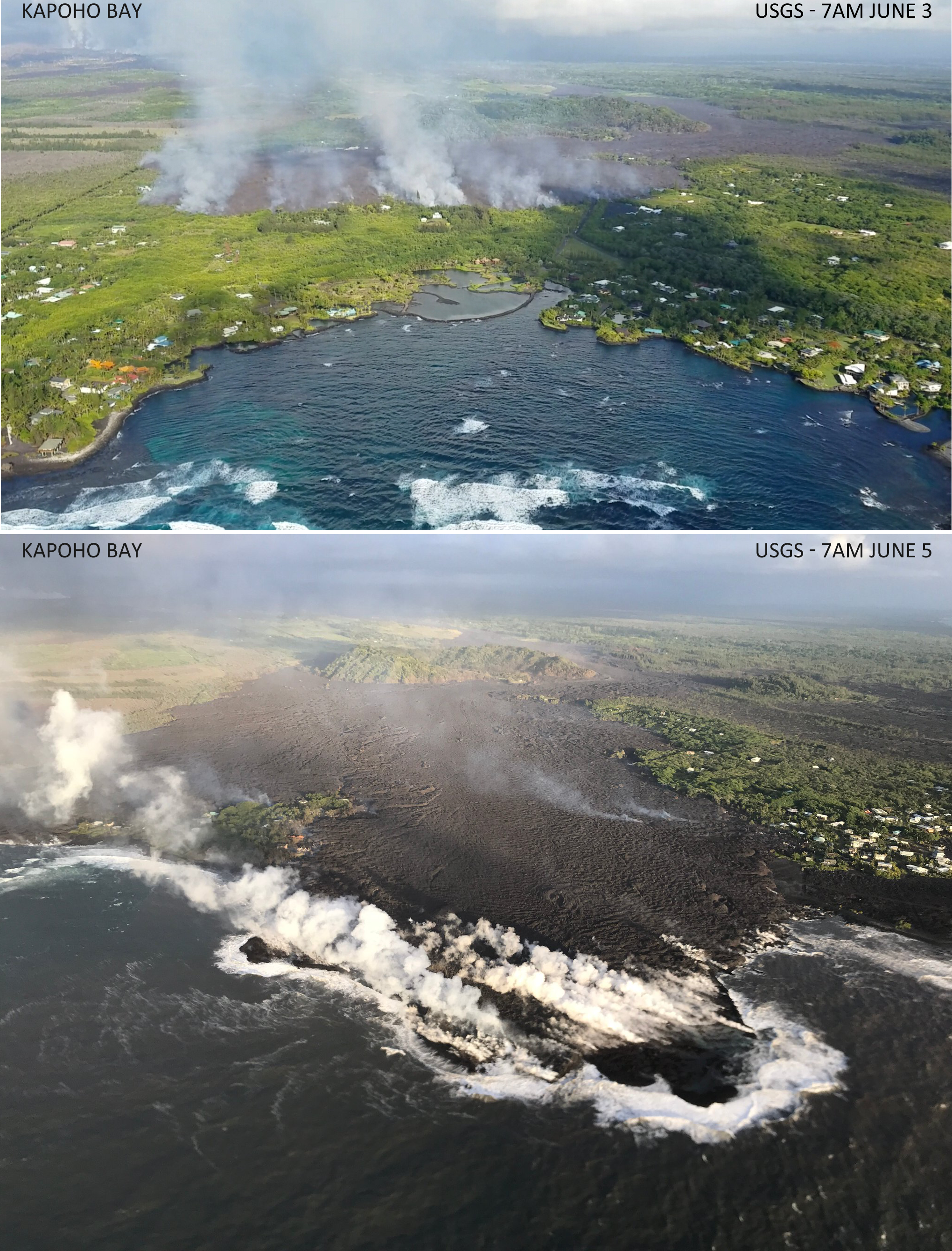
Lava reached Kapoho Bay on Saturday night, around 10:30. By Tuesday morning, it was Kapoho Point. There were hundreds of homes here, plus farms, tidepools, and marine life.
There was another small predawn ash explosion up at Kilauea’s summit, where we can now watch the changes to Halema’uma’u Crater (see below). HI Civil Defense, the Dept. of Health and EPA have set up a new network of sensors to monitor and report air quality in realtime, which should help the rest of the island.
But Vacationland and Kapoho Beach Lots have now followed the 1960 village of Kapoho into memory.
Of course, that’s not the whole story for today. There’s new images and videos, USGS updates and info, articles on the eruption’s impact from local Hawaiian news outlets, and eyewitness reports and reactions on social media. So here’s the usual daily roundup of Kilauea eruption news.
While Kilauea claims homes, possessions, and places people loved— and animals, sadly— it’s a relatively benign volcano (as long asit remains in its lava-gushing“effusive phase”). Its “ballistic rocks” can’t fly much farther than half a mile. Ash and vog hamper quality of life, but aren’t instantly deadly. Its lava moves slowly enough for people to escape. Lava creates new land while it destroys, and it breaks down eventually into fertile soil. While it’s destructive, it’s also beautiful:
This is a "waterfall" of lava pouring into Green Lake that is inside the Kapoho Crater on Green Mountain. The lake…
That’s the life’s blood of a shield volcano like Kilauea. But there’s another kind of volcano I’ve mentioned before: stratovolcanoes like Krakatoa and Mount St. Helens. Their silica-rich, stiff, sticky lava piles up into steep mountains that can bottle up tremendous pressure before letting go. I’m afraid that’s probably what happened in Guatemala today.
Careless news media (even the BBC!) are claiming that a river of lava from volcan del Fuego killed over 20 people and injured dozens more. But all the videos I saw (apart from videos of Leilani Estates passed off as Guatemala) show pyroclastic flows:
Please spare some compassionate thoughts for the Guatemalans caught in this eruption. Most of them probably thought those gray clouds were just (cooled) ash, like what’s irritating Hawaiians living downwind from Halema’uma’u. (No, Kilauea’s not going to do that.)
Today’s kilauea eruption summary
USGS caption: “Photo from 7AM helicopter overflight, hovering offshore and looking up the flowfront. Nearly all of the front was active and advancing; advance rates were estimated at an average of 250 feet/hour (76 m/hr), and as of 7AM the flow was 500 yards (457 m) from the ocean.” (Full-sized)
As for Kilauea, the main news today was fissure 8’s lava flow making its finall approach to the shore through the Kapoho Beach Lots/Vacationland area.
And as if in response to news media headlines claiming it’s “fallen quiet,” the summit woke up again with a whole popcorn-popper’s worth of earthquakes, including a beefy M5.5 in the afternoon and an ash cloud rising to 8,000 feet.
Here’s my daily digest of Kilauea eruption news, including:
Updates/info from the USGS and other geologists
eruption news from Hawaii Civil Defense
Local news stations covering the eruption and its impact
relevant social media posts by informed eyewitnesses
Fissure 8 continues to pump out vast amounts of lava, although it’s slacked off a tad from yesterday’s 260-foot display. One of its fingers burned a building or two at PGV. Other lobes closed in on Kapoho throughout the day, touching Highway 132 again half a mile north of Four Corners at 3:30. Fissure 18, which has been sending a flow east and down towards the ocean, has pretty much stalled apart from some small breakouts. Authorities were ordering Kapoho-area residents out today before lava cuts their only remaining road to the rest of the island.
(That’s a photo of Four Corners, which is the intersection of Hwy 132 & 137. Apparently the lava’s started using 132 as a shortcut again.)
The summit has been steaming and vogging away, but the overlook vent has now been choked with debris falling from its walls. Ash explosions have nearly stopped since the 11am May 30 ash eruption that rose 12,000 ft. Scientists are trying to figure out whether this means the main explosive phase is finished, or whether it’s going to build up enough pressure to blow out the clog. (That said, the crater has not “fallen quiet,” as many non-Hawaiian news stations claimed today. According to @NWSHonolulu, there was a minor “burp” of ash just after 1:30pm.)
A relatively clear day, May 31, finally allowed the USGS to get good, detailed drone footage of changes at the summit.
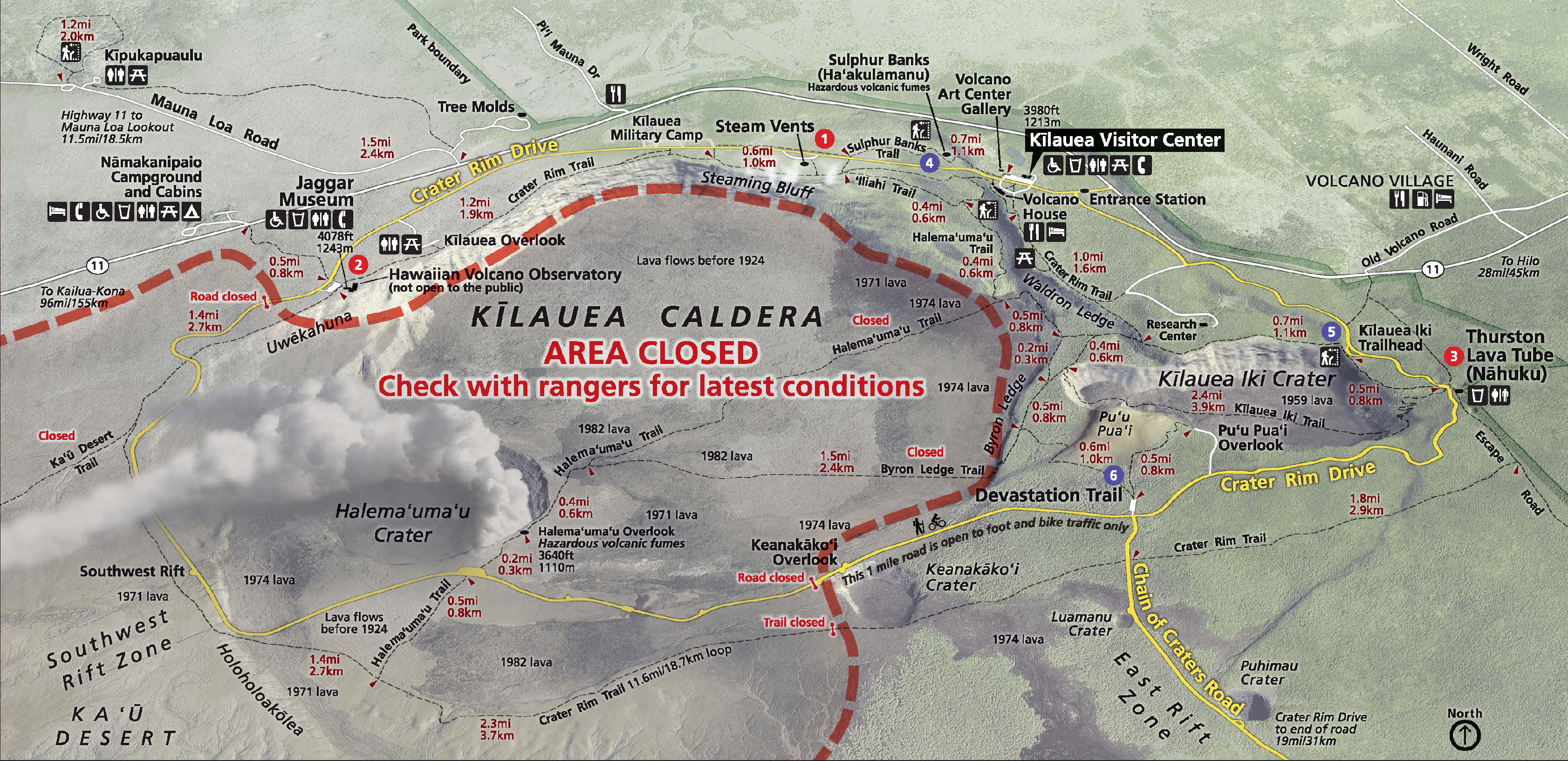
To orient you on the crater-within-a-crater-within-a-crater (Park Map):
Kilauea Caldera is the megacrater, 2×3 miles across, on whose cliff walls are perched the Hawaiian Volcano Observatory, Kilauea Visitor Center and Volcano House.
Halema’uma’u is a crater on the floor of Kilauea Caldera, about 2500 x 2900 feet. It held a lava lake in the 1800s, but drained and exploded in 1924, after which it was quiet for most of the 20th century.
The Overlook Vent was a crater on the floor of Halema’uma’u containing a lava lake from 2008 until May 2018. It drained and has been exploding with steam and ash since the beginning of May. Rockfalls from its sides have enlarged it:
changes at kilauea’s summit, May 2018
May 5-29, USGS animation using radar data from Italian Space Agency’s Cosmo-SkyMed satellite:
May 23-31, new radar imagery shows more recent changes. The USGS caption notes that not only has the overlook vent widened, but also Halema’uma’u Crater:
USGS Animation of recent changes at Kilauea’s summit, radar images taken by Italian Space Agency’s Cosmo-Skymed satellite.
Below, a compilation of video footage of Halema’umau and its lava lake in August 2016. Go to timestamp 2:10 for a good view of Halema’uma’u Crater with the Overlook Vent’s lava lake inside. Compare that with the May 31 video above. The black area is lava that overflowed onto the floor of Halema’uma’u when the lake’s level was high.
Note: the “Overlook Vent” was named after the old Halema’uma’u Overlook, because that’s the side where the lava lake vent opened in 2008. There used to be a parking lot and viewing area on Halema’uma’u’s crater rim where visitors could look down into it. In 2008, the Overlook area was closed to visitors, because whenever there was a rockfall into the lake it tended to do THIS: