Full unabridged audio here. Abridged version in video:
transcript/paraphrase of full conference call (my notes):
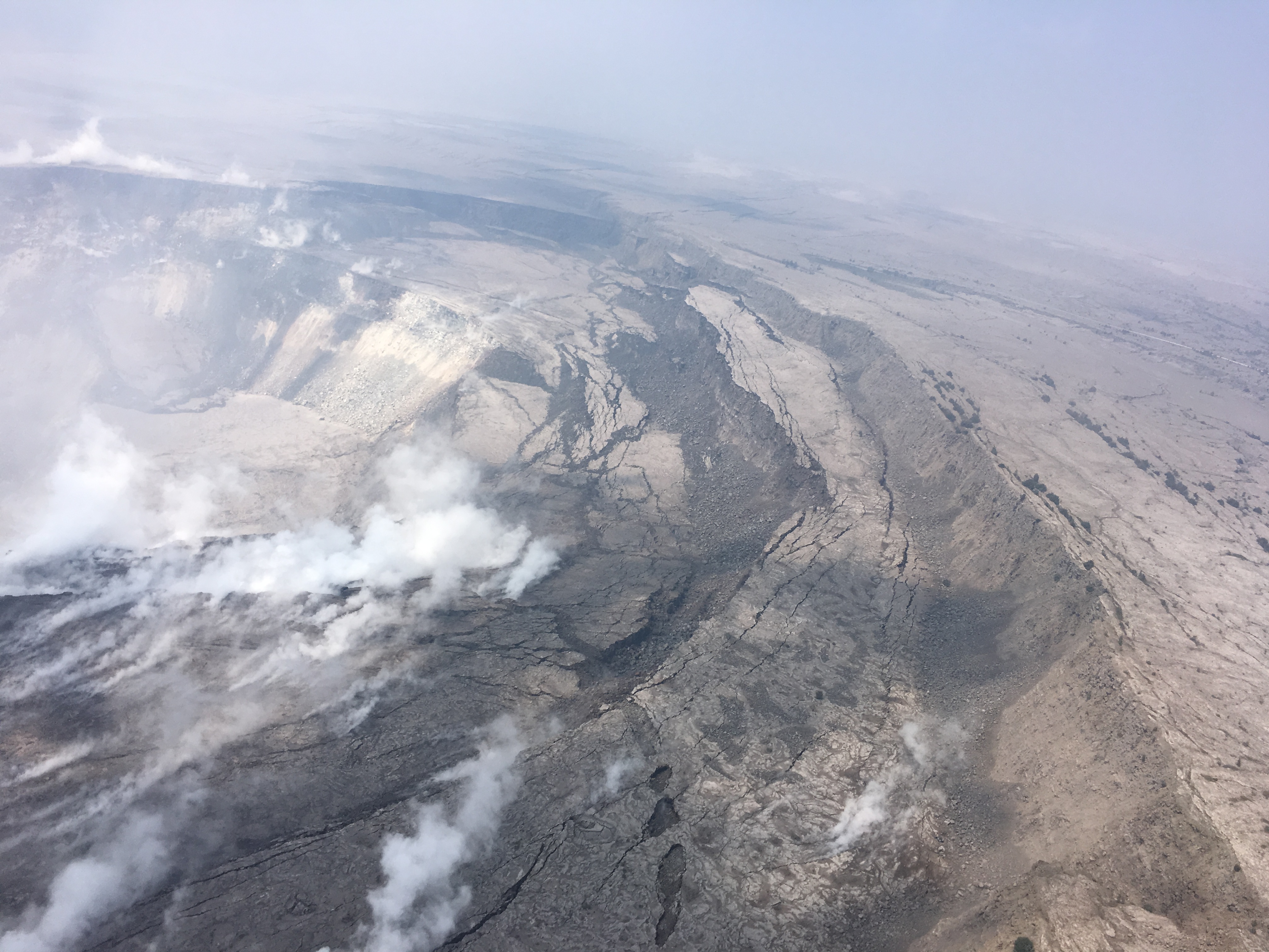
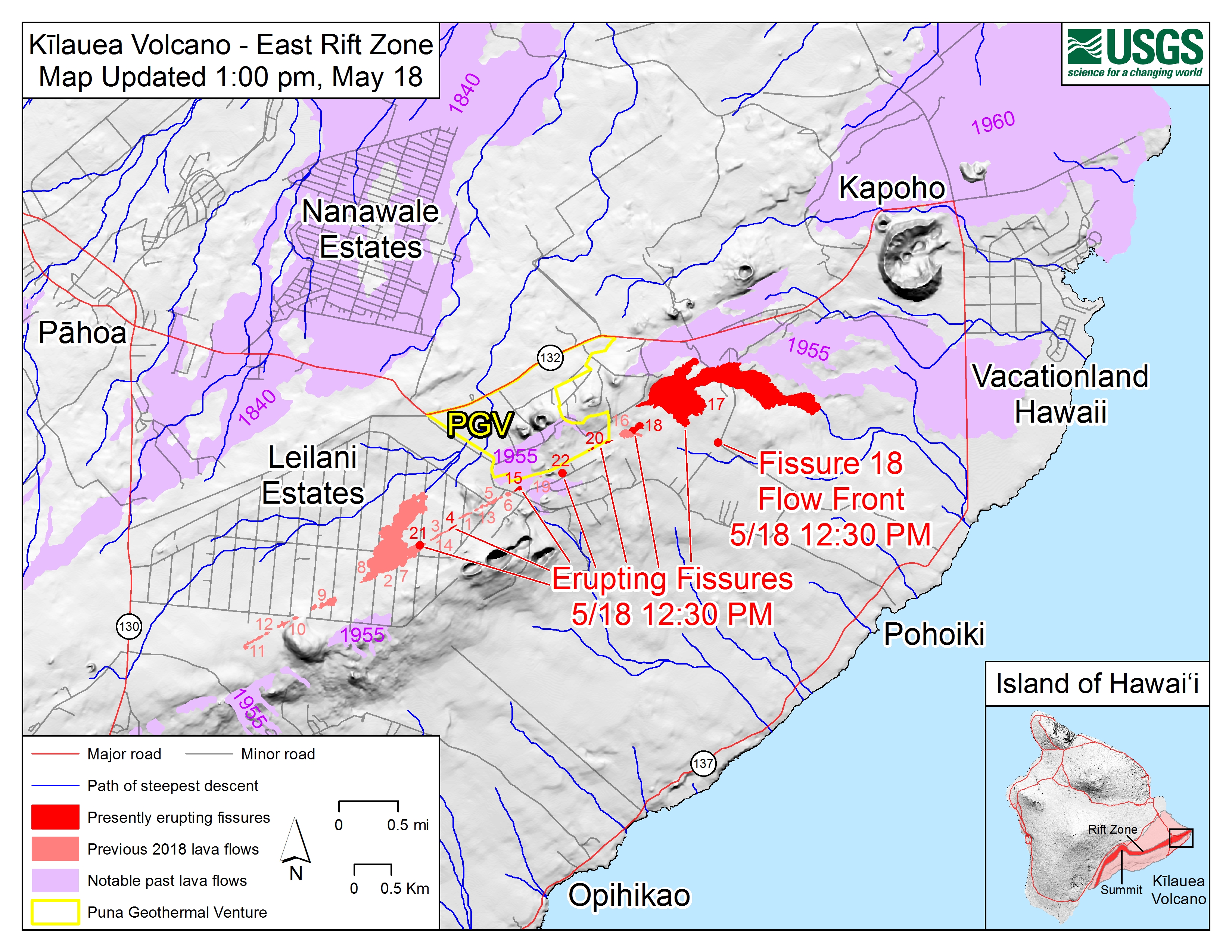
ERUPTION SUMMARY by Steve Brantley, Deputy Scientist-in-Charge HVO [timestamp 02:30]: LERZ eruption continues with same vigor as it has in past 1-2 weeks. Lava upwelling from Fissure 8, forming a lava fountain, and flowing through a channel all the way to the ocean. Ocean entry flow front almost a mile wide. Lava entering ocean at multiple spots. Haven’t detected any change in vigor of eruption.
Summit: Explosive event occurred at 2:44am. Followed 12-24 hrs increased seismic activity. Similar to pattern of explosive seismic events of past 1-2 weeks. Accompanied by additional subsidence (10 ft) of crater floor right next to Halema’uma’u crater rim. Common for these events. “Downdropping as well as slumping towards Halema’uma’u.”
[4:40] Jessica Ferracane Hawaii Volcanoes NP. About same. Yesterday park rangers spotted more cracked roads.
[5:30] Matt Foster, NWS.
Question & Answer session.
Q: Do you see irregularities, anything happening at Mauna Loa causing concern? [Question inspired by conspiracy theory/hoax all over web.]
[09:00] Steve: Mauna Loa activity declined in vigor over past year. New activity at Kilauea had no effect on Mauna Loa whatsoever. Some small earthquakes at Kilauea, but ground deformation, change in shape of volcano has decreased considerably for past several months to a year.
[Q on amount of new land created; Steve doesn’t have current figures available.]

Q How far can subsidence at Halema’uma’u keep going— how far down? [11:00]
USGS Geophysicist Ingrid Johanson: The large amount of subsidence seen at that GPS station [10 foot drop mentioned earlier] mainly related to slumping of blocks into Halema’uma’u Crater. We’ve seen other blocks drop tens of meters as they’re falling in. So essentially, that was landsliding rather than deflation of summit reservoir.
Q: [12:20] Update on broken radar… are there other ways to detect overnight ash plumes?
A: Matt of NWS: We’re waiting for a part, don’t have eta on installation yet. Without radar, rely on help on USGS/HVO (how power earthquake is, what infrasonic signal is, which can help suggest ash explosion.) IR satellites can’t detect signal unless it’s large.
Q: [longwinded convoluted question] someone told him this is the most destructive earthquake since 1980 eruption of Mt St Helens. Is there any other earthquake, going back in history, that’s more destructive? Katmai, for example?]
A (Steve): To clarify, those are/were eruptions. It’s true that this eruption has covered more homes than 1990-1991 Kalapana, and more than 1955, 1960 Puna/Kapoho eruptions.
[Same guy: I guess there wasn’t a lot of property losses at 1984 eruption of Mauna Loa?]
Brantley: No homes lost in that eruption. In 1950 lava flows from Mauna Loa went to west coast of island, did bury some communities.
[Same guy: You don’t know the extent of damage from that, do you?]
Brantley: Not off top of my head; check historical section of HVO website.

Q on whether new fissures could open [19:30]. Steve says yes, eruption is still quite strong. Although for past couple of weeks activity focused at Fissure 8. But old fissures could reactivate, new segments/fissures could become eruption site. We’re not predicting it; we’re trying to keep track of overall Rift Zone and where it’s becoming pressurized. For past few weeks, overall Rift Zone relatively stable, not widening, not pressuring anywhere. Just “nice steady stream” of magma going through rift zone.
Q: What date was last new fissure? A: Don’t have off top of my head, check HVO status updates on website. Added postscript about how USGS is monitoring cracks (extension, widening, temperature, steam) to watch for signs of new fissure eruptions. No change lately.