Today’s Eruption Summary
One gets the sense that crisis mode is giving way to some sort of new normal, as it did during the decades of the Pu’u O’o eruption. Not that one can ever call this normal:
Still, public meetings are no longer dominated by talk about lava, fissures, and SO2 so much as how to collect on insurance and find housing. The USGS has dropped weekend video briefings to give its staff a much-needed break (alerts/info are still posted on the HVO website). Hawaiian news outlets are reverting to a more typical news cycle, with only 1-2 new Kilauea updates a day.
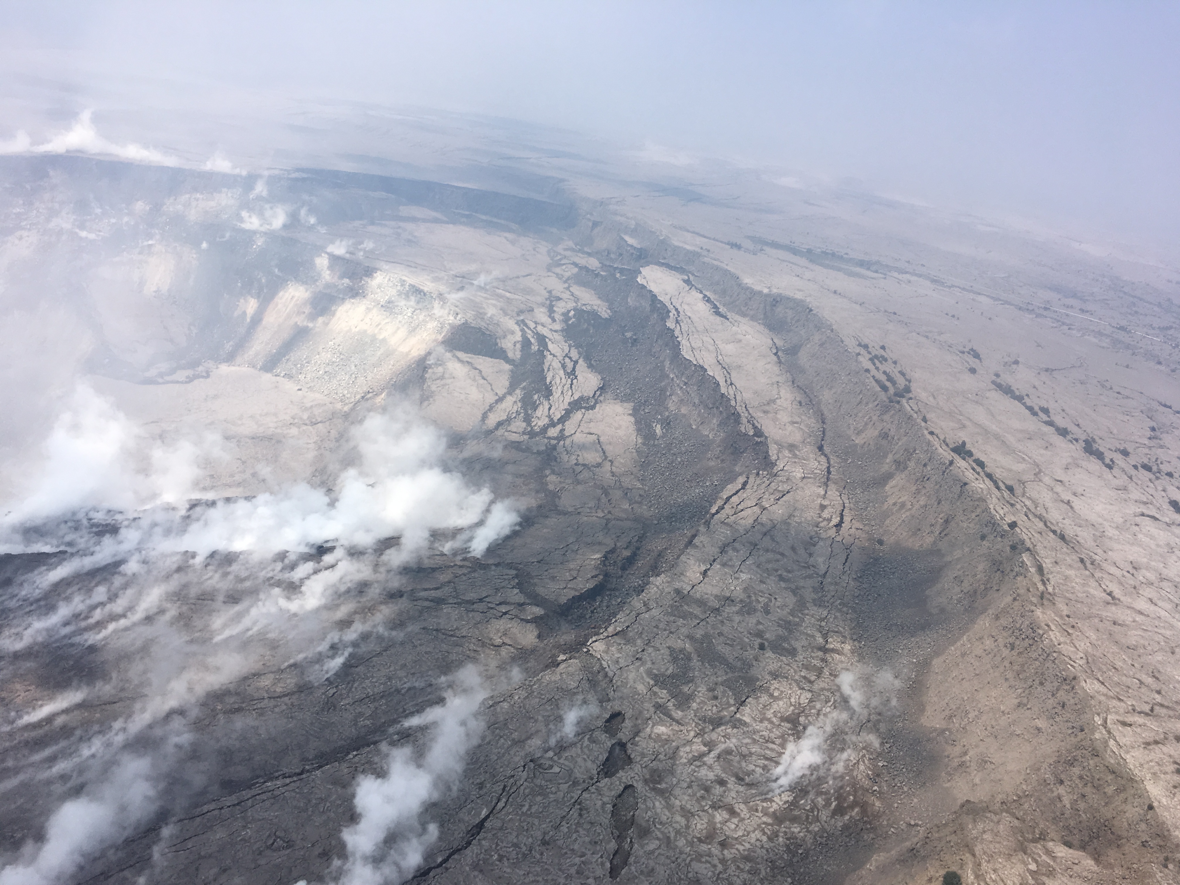
At the summit, steam/ash explosions continue their recent pattern. Today’s explosion registered as M5.2 at 4:48am, shaking the village of Volcano; it was felt as far away as Hilo. (Local radar is still out, but the ash cloud was small, less than 10,000 feet, since satellites can spot bigger ones).
Halema’uma’u is looking very ragged around the edges:
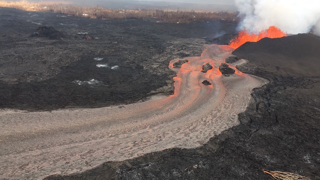
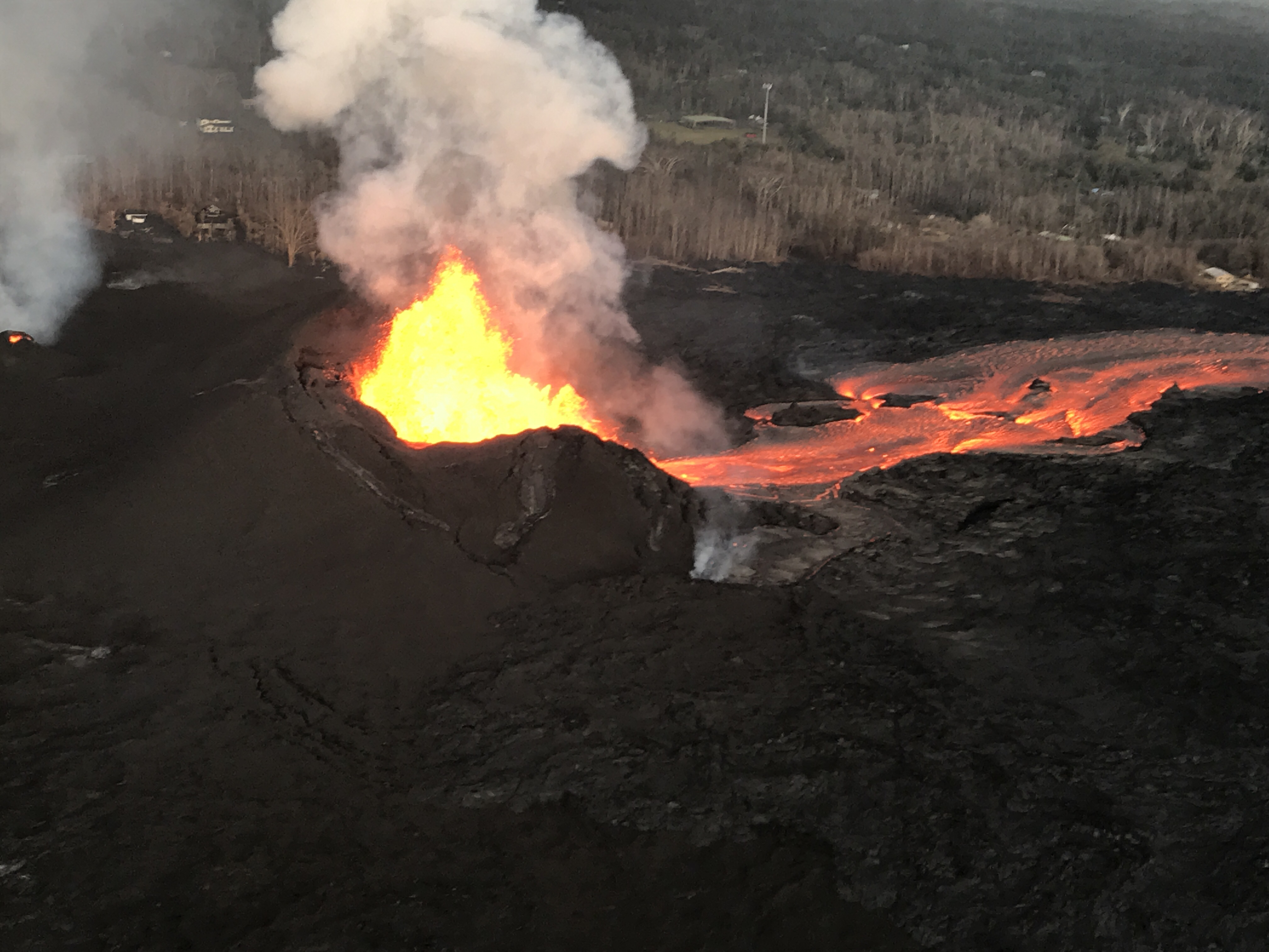
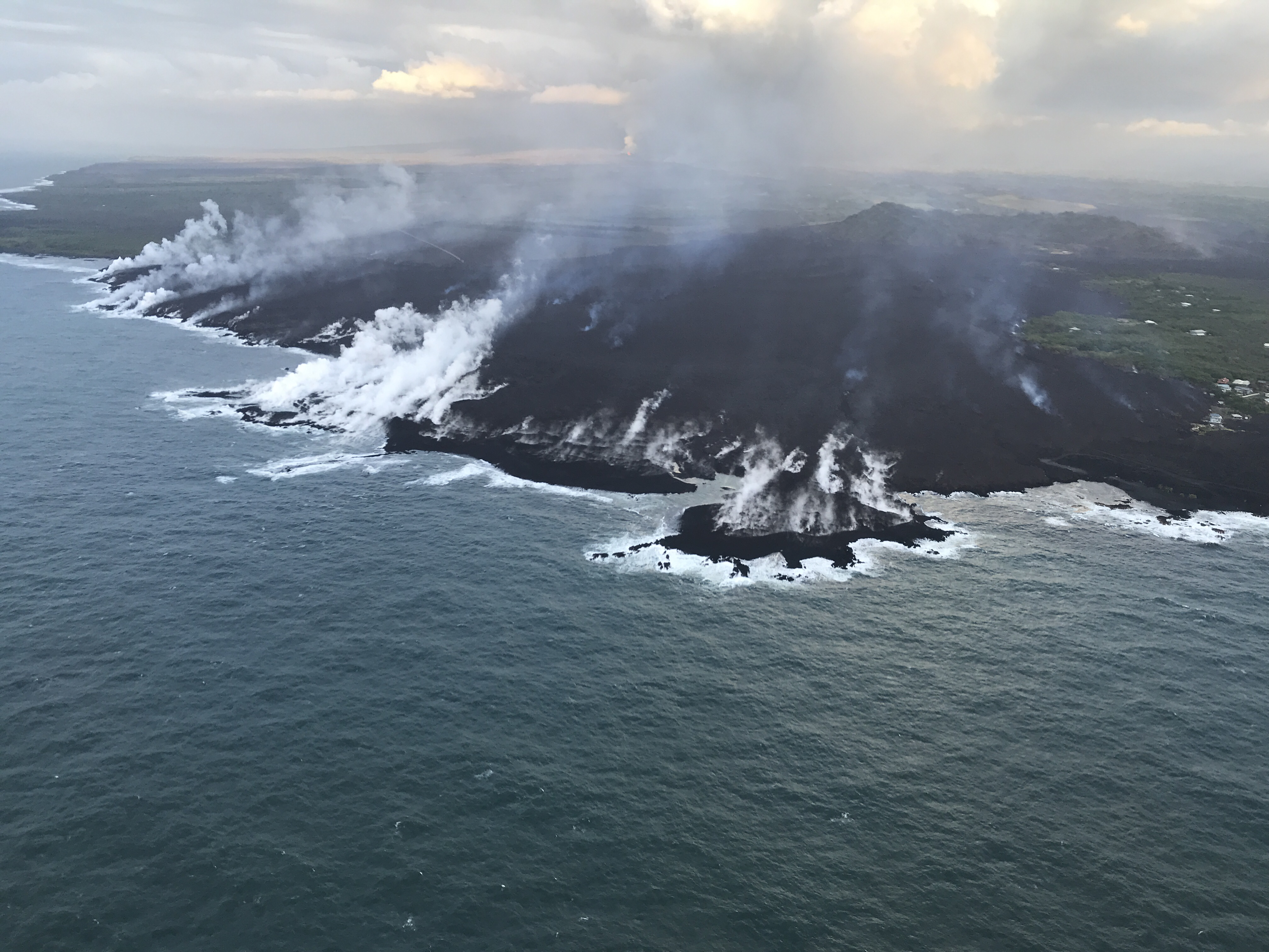
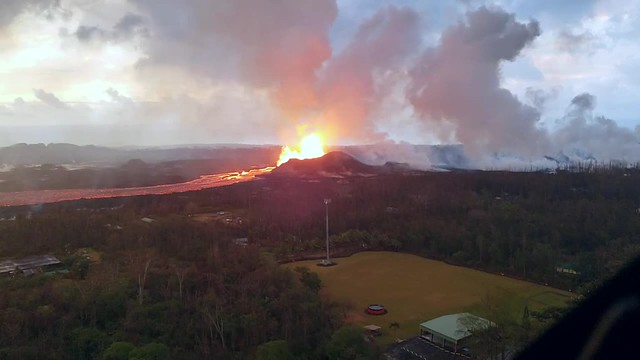
In the Lower East Rift Zone, Fissure 8’s fountain has tapered off slightly, down to 130-160ft with occasional bursts up to 200ft, but its lava river is still going strong. As of 6:30am, the new lava delta at Kapoho had grown to 200 acres. An elevated section of the flow near Lava Tree State Park caused some concern this afternoon when it started overflowing its levee, but it settled back into the main channel without a major breakout.
[another amazing Fissure 8 overflight video from Mick; here’s his notes, including rough estimate from USGS: 6-9 million cubic yards per day!]
The Pu’u O’o webcam has even more scunge on it today than yesterday, when there was a few rockfalls and a brief plume of “rock dust.” There were more rockfalls this morning. Earthquake activity under Pu’u O’o is still negligible, however.
I’m running late tonight, so here’s a somewhat abbreviated weekend edition of USGS info, eruption news, images and videos, including timelapses of the summit and fissure 8 for the past week:
USGS PHOTOS for June 9
Remember to look for houses in these pictures; it’s easy to lose track of just how enormous Fissure 8 is. Even on a subdued day, its fountain is half the height of the Statue of Liberty:
USGS video clips of Fissure 8 fountaining from last night:
While lava deltas are usually unstable and tend to wash away, I’m wondering if the shallow waters of Kapoho Bay, the thickness of this flow, and (sadly) the reefs it covered will anchor it better than most.
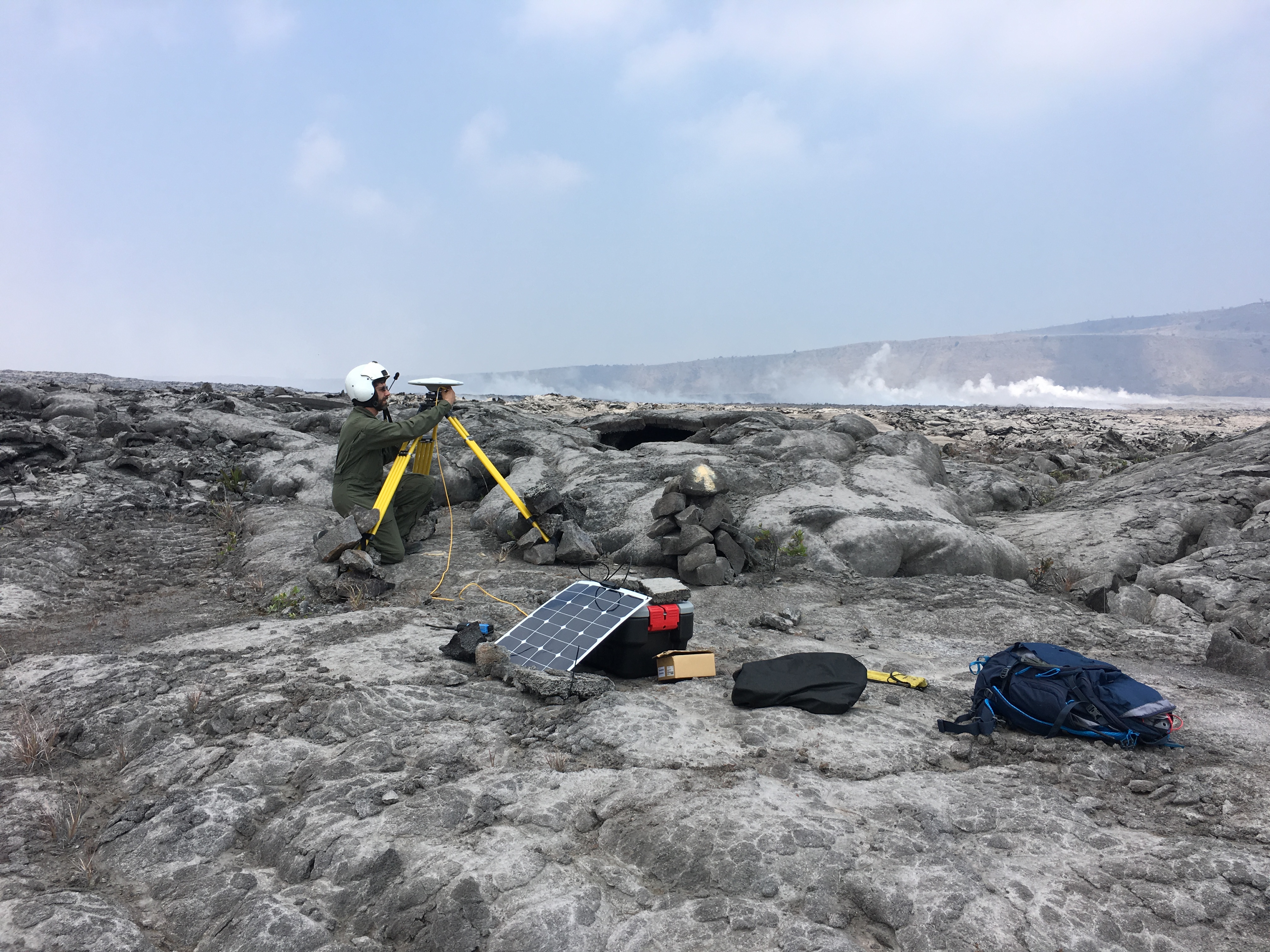
Below: how’s this for a risky job? “Let’s find unstable places around Halema’uma’u’s rim, and stay there long enough to set up our complicated equipment!”
Webcam Timelapses last Week
Hawaii247 takes screengrabs from all of HVO’s webcams, then compiles them into weekly timelapse movies on YouTube. These are from June 1-7.
Notice the intermittently steaming cracks on the ground to the left of Halema’uma’u’s rim.
And here’s the LERZ:
There’s timelapses of four other views of Halema’uma’u posted on their channel, if you’re curious. (I think one is a non-USGS cam, perhaps set up in the town of Volcano?)
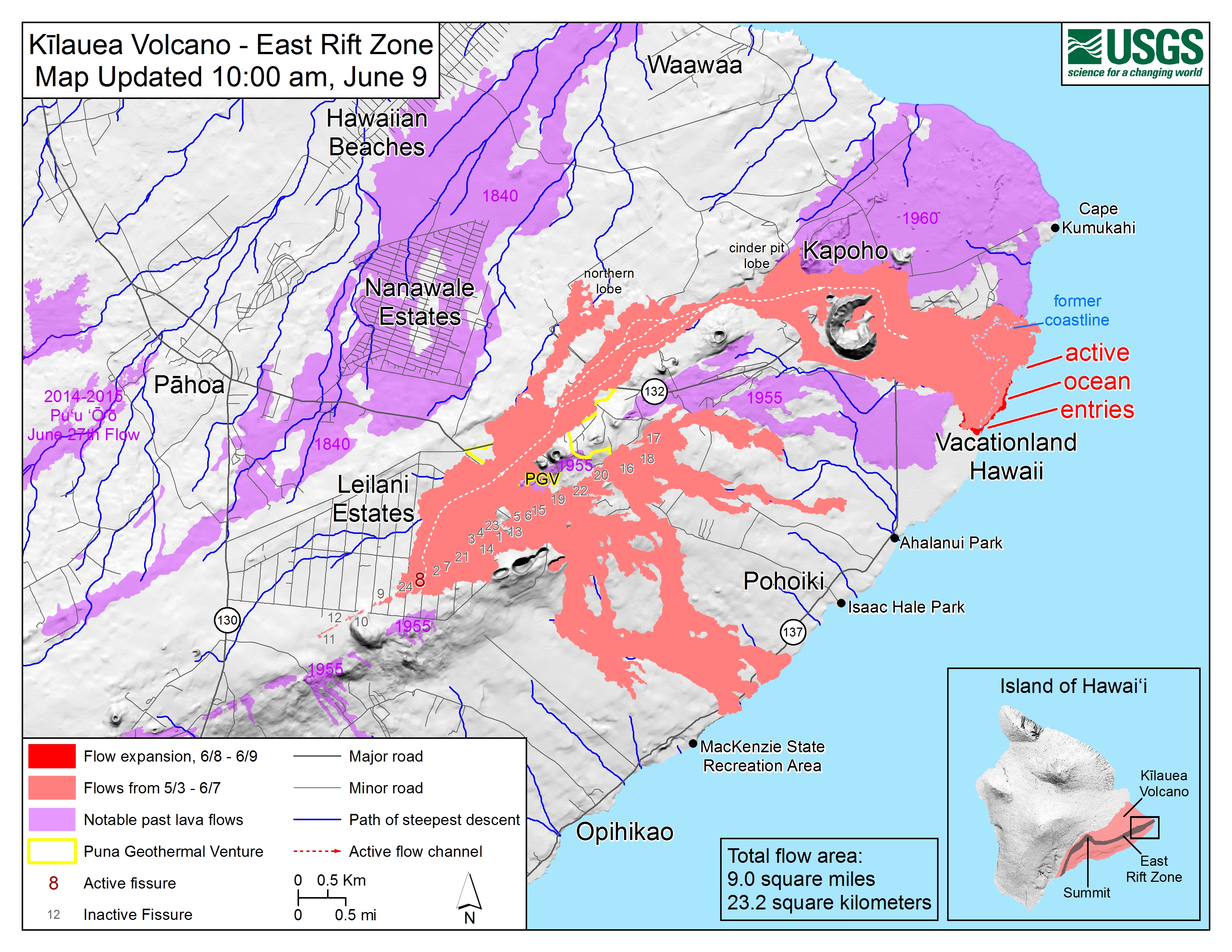
JUne 9 usgs lava flow map
Last HVO Status Update for today
Kīlauea Status Report: 10:37 PM HST, June 9, 2018https://t.co/7sDZqcx8dU
No major changes at Fissure 8, channelized flow, or ocean entry. Summit seismicity building, and a small explosion is expected during the day on June 10. pic.twitter.com/H3ZMIlcqV5
— USGS Volcanoes🌋 (@USGSVolcanoes) June 10, 2018
HVO on Social Media
USGS may have cut back on weekend video briefings and conference calls, but their social media team is still putting in long hours to answer questions.
We won't be able to inspect the delta at all until flows stop going into that area. Though, based upon past ocean entry and bay filling in Kalpana, this one may turn out to be much like Kaimū beach.
— USGS Volcanoes🌋 (@USGSVolcanoes) June 10, 2018
That is the cone that has been forming around fissure 8. It is well on its way to becoming a new cinder cone. #Kilaeua #KilaueaErupts #LeilaniEstates
— USGS Volcanoes🌋 (@USGSVolcanoes) June 9, 2018
That answers my question about whether to call it s a cinder cone or spatter cone. It’s not a new volcano, by the way. It’s just a new vent on Kilauea volcano like Pu’u O’o, Mauna Ulu and Kilauea Iki, all of which were supplied by magma from Kilauea’s plumbing.
The length of this flow is pretty amazing.
Our geospatial team measures about 13 km or 8 miles from fissure 8 source to the ocean entry. That's a long river of lava!
— USGS Volcanoes🌋 (@USGSVolcanoes) June 10, 2018
I wonder how wide it is? It varies, obviously, but it looks enormous in overflights.
Different view. The KIcam has a wider angle view than the lifestream. But, yes…part of the northern rim slumped a bit today. #Halemaumau is still growing!
— USGS Volcanoes🌋 (@USGSVolcanoes) June 10, 2018
It’s odd how, when Kilauea lets loose with an unusually big and spectacular eruption, some non-geologists start claiming that something much, much bigger is about to happen, almost as if they’re not satisfied with the drama so far:
While #Halemaumau Crater is collapsing, the entire #Kilauea Caldera is NOT collapsing – it is subsiding (lowering). There is a big difference between that and a catastrophic collapse. #Kilauea does not have Pinatubo-style caldera collapse eruptions. #KilaueaErupts
— USGS Volcanoes🌋 (@USGSVolcanoes) June 9, 2018
Anthony Quintano can sympathize: the moment you put up a livestream, people start asking you to adjust the camera.
Unfortunately we don't have a vantage point that can show the entire crater now – it's gotten that big.
— USGS Volcanoes🌋 (@USGSVolcanoes) June 10, 2018
The daily conspiracy theory whack-a-mole:
Hydrofracturing did not cause the eruption. #Kilauea is an active volcano and has had many cycles of fissuring and explosive activity, (https://t.co/lfmS4Xz4Bs), none of which were caused by humans.
— USGS Volcanoes🌋 (@USGSVolcanoes) June 9, 2018
[rant]A moment’s thought would debunk this hoax, since there are old lava flows, spatter cones, not to mention films and pictures of similar eruptions in Puna decades before the plant was built. Pu’u O’o erupted for 35 years before lava output shifted downrift to Leilani Estates. Even then, no fissures opened near the wells; the lava that covered them came from outside PGV property.
Most of all, I wish people would stop misusing the word “fracking” for any sort of hole in the ground. It’s a new word coined to describe a new process for oil extraction, which deliberately cracks and weakens rock in a wide area. Wells don’t work like that. If they did, there would’ve been no need to invent fracking![/rant]
And no, it wasn’t our imaginations…
Yes, there was an earthquake yesterday that caused a series of rockfalls into #PuuOo. The red/pink plume is from oxidized (rusted) rock in the walls of the crater.
— USGS Volcanoes🌋 (@USGSVolcanoes) June 9, 2018
June 7 overflight speeded up
This is from the Hawaii County Fire Dept a few days ago. Sped up, one really has a sense of the entire flow from source to sea:
From Other Geologists (or at least scientists)
- George Dvorsky, Gizmodo: “Which Volcanoes Are Most Overdue for Eruption?”
Hawaii Civil Defense Alerts
This afternoon, the built-up lava channel started overflowing near the intersection of Highway 132 & Pohoiki, triggering warnings for residents in that area and Lava Tree State Park, but it settled back into the main channel without a major outbreak.
5AM (ash eruption) | 6AM | 12PM | 3PM (“perched flow” warning) | 4PM (outbreak contained) | 6PM
Local News Outlets Stories
- Lower East Rift Zone Eruption:
HTH: “With only one active fissure, county eases into ‘recovery phase'”
HSA: “Lava crawls along ocean floor as vog changes direction”
HNN: “Lava produces 200 acres of new land in ongoing eruption.” - Human (and nonhuman) Impact:
HTH: “Residents displaced by lava seek answers on insurance”
KITV: “Hundreds of animals are scattered around Hawaii Island following volcanic eruption”
HNN: “‘We’re gonna get it done today’: Volunteers put finishing touches on emergency shelters for evacuees”
HSA: “Prolongued papaya shortage expected in wake of volcanic activity”
BIVN posted a video of Mayor Harry Kim addressing County Council June 6, “Needs Are Greater Than We’ve Ever Seen.” - Miscellaneous:
HPR: “How Kilauea Strengthened Kamehameha’s Rise”
HNN: “USGS addresses rumors: ‘Mauna Loa is not erupting'”
Social Media Roundup
What a wild 6 weeks its been. And an unknown number ahead for #KilaueaEruption on #Hawaii: pic.twitter.com/kiXE3X1tt0
— the Weatherboy (@theWeatherboy) June 10, 2018
Animated GIF showing latest lava flow in relation to the same location on Google Earth. I created the GIF from images sourced from the USGS and Google Earth.#kilauea #kilaueavolcano #volcano #kapoho #kapohobay #lava pic.twitter.com/0WOXFoXGOT
— Michael Goss (@mikenimbus) June 9, 2018
Andrew Richard Hara posted another handful of good photos from a helicopter overflight. Here’s the first of the batch:
- Another gorgeous photo of the Milky Way and lava glow in the distance by Traylor Photography (“All Rights Reserved,” and embedding doesn’t show caption/photographer name, so I’m just linking.)
Nice stuff! 🙂 Interestingly, it's not really clear how long it'd take for a magma reservoir to go from a state of quiescence to primed to erupt. That cited paper suggests a year/few months (for one particular chamber), but another says 10k years minimum. So 🤷♂️basically!
— Dr Robin G. Andrews (@SquigglyVolcano) June 9, 2018
Picture shared by @USGSVolcanoes of inside closed @Volcanoes_NPS on right looks a little like shot of Mars surface from @NASA's Pathfinder, left. #Mars#KilaueaEruption #rockExplosion#ash pic.twitter.com/CeGuWmGHzU
— the Weatherboy (@theWeatherboy) June 10, 2018
Interesting to see some freshly-covered-by-lava lots come online in realty listings on #Hawaii's Big Island, most with disclaimer, "Buyer & Agent to investigate all pertinent & material facts and not solely rely on information supplied by the Listing Agent and of Listing Office." pic.twitter.com/oo7S0l7rTW
— the Weatherboy (@theWeatherboy) June 9, 2018
Apparently a lot of us have noticed and are thinking it:
Imagine the explosion when that big chunk on the left falls in.
— lavapix.com (@lavapixcom) June 9, 2018
And we’re all hoping it happens during daylight so the livestream cam can catch it, right?
New blog post with 2 new videos. Photos will come later. https://t.co/oSRUyc6yda #Blog #WordPress #SaturdayMotivation #halemaumau #Hawaii #hvnp #hppa #volcano #Kilauea #lava #NEWSで妄想 #KilaueaVolcano #LeilaniEstates #BigIsland #eruption #Greenlake pic.twitter.com/txEmgKfvek
— lavapix.com (@lavapixcom) June 9, 2018
Finally…
A reminder to thank and/or appreciate the USGS team for hard work and over a month of sleepless nights:
@USGSVolcanoes Y'all continue to do an amazing job with social media (and everything else). Please pass on deepest gratitude to all of the USGS/HVO scientists and staff and all of their families. Mahalo nui loa.
— CJ Moose ⚒🌋 (@cjmoose) June 10, 2018