Today’s Eruption Summary
Fissure 8’s eight-mile lava river and the summit’s daily explosion have followed their usual pattern of the past two weeks. However, volcanic gas emissions at the Lower East Rift Zone doubled on Saturday compared to the past week, while SO2 emissions from Halema’uma’u are about half what they were before this current eruption started.
Are those two facts linked? I dunno. I’ll be interested to hear if/when lava samples collected from the Fissure 8 flow start to show signs they came down from the summit instead of Pu’u O’o.
Before-and-After Halema’uma’u 2017 vs 2018
I found a July 2017 screencap from HVO’s panorama webcam, so here’s an animation fading from it to today’s view. Check out the full-sized animation; you can really see how much Halema’uma’u has enlarged.

Below: slow news day, lots of photos.
Be warned, there’s some sad news, especially in the social media section at the end. This is a natural disaster, and it’s hard, even if it provides some amazing visuals and fascinating science as compensation. But they can’t make up for what’s lost.
USGS PHOTOS For June 10
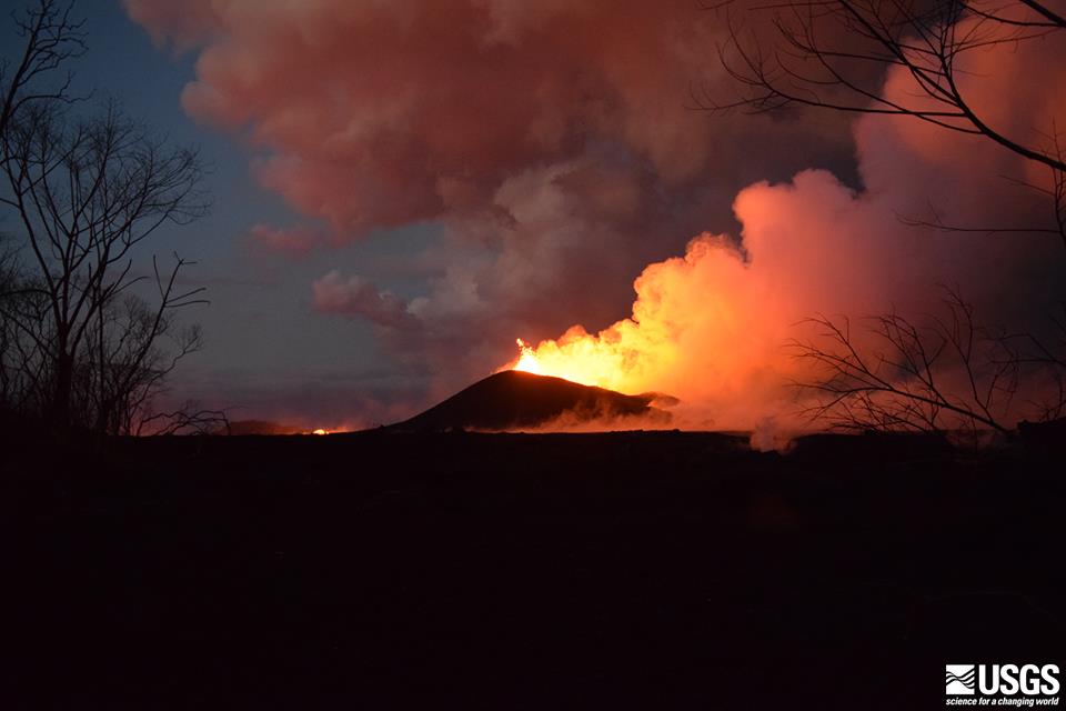
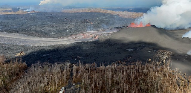
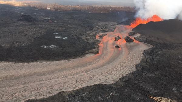
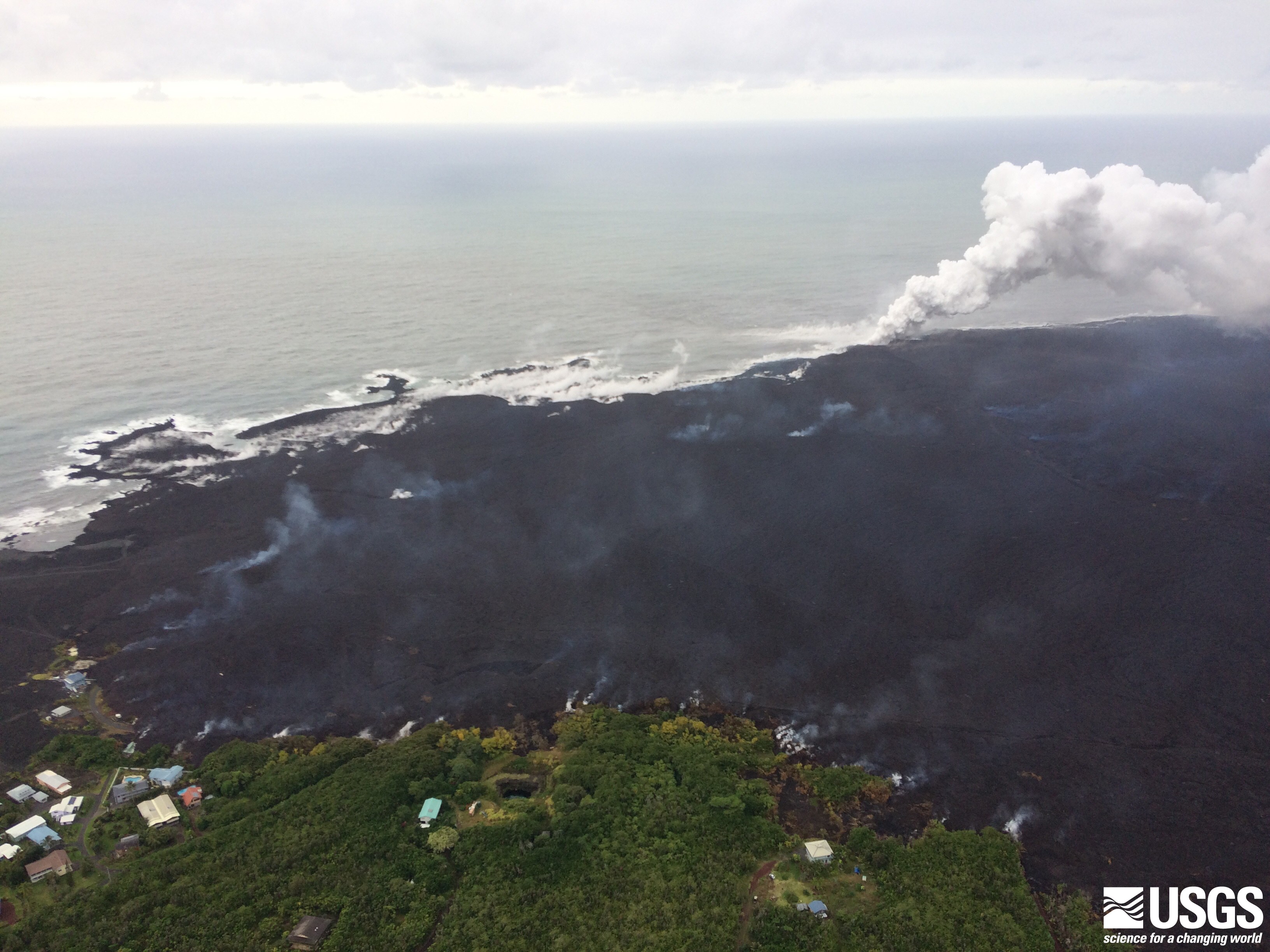
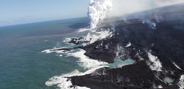
Fissure 8 during 7AM overflight, looking much as it did yesterday:
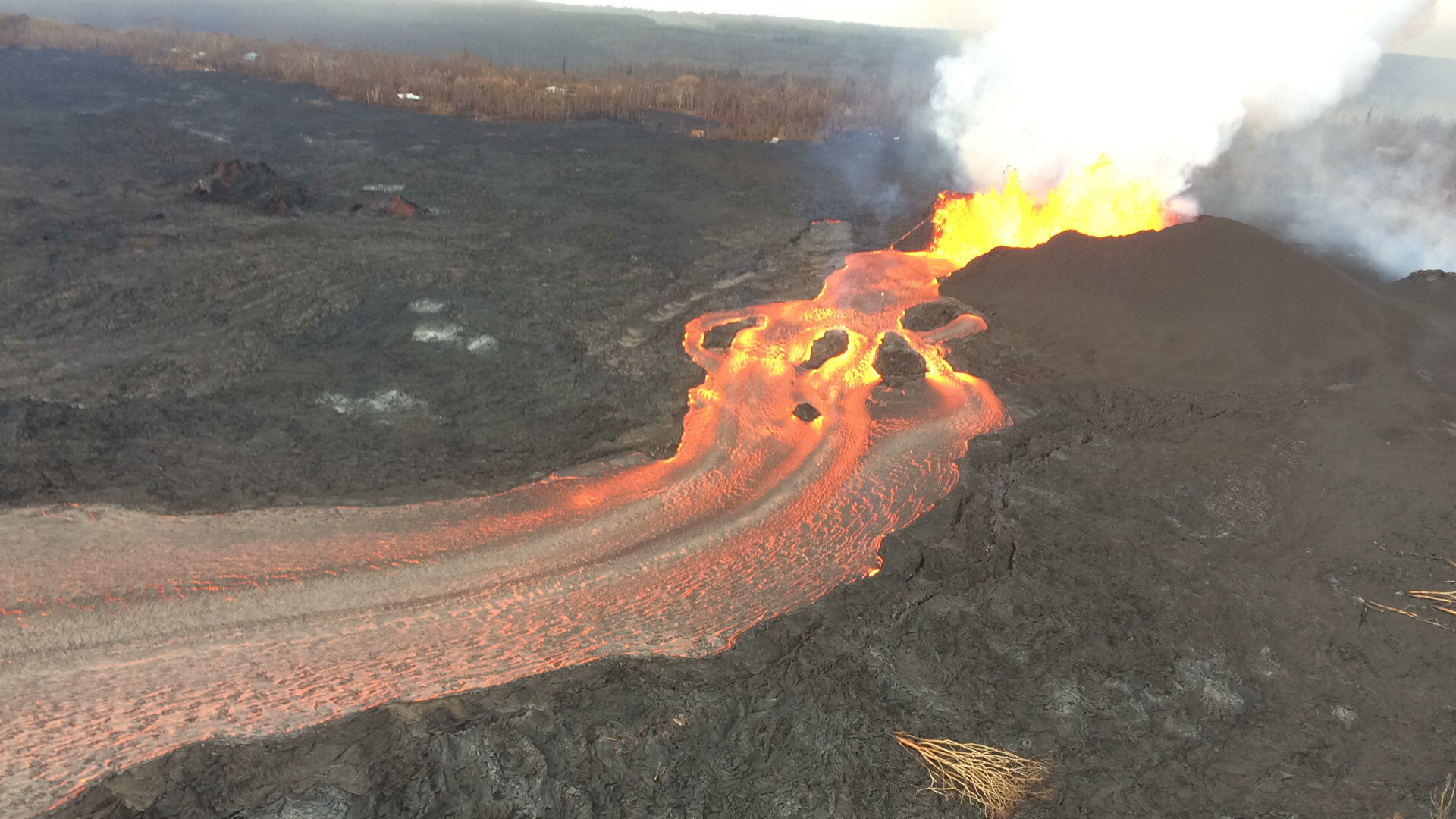
100-300 meters wide: my boldface, because I’ve been wondering how wide that channel is. Up to three football fields, yo.
I’ve been hearing about breakouts encroaching on a “cinder pit” for a while. Here’s where that was. That “cinder pit” must be from a previous eruption much like this one.

Here’s the breakouts near (or on top of? not sure) the corner of Pohoki Rd and Highway 132 that have been causing concern for the past two days.

So far, these little overflows are just solidifying on the channel’s banks, building the levees higher. But they have to be watched closely, because if they ever gain momentum (aided by the “perched flow” and gravity), they could start a new, fast-moving lava flow, or even divert the existing channel into a new one.
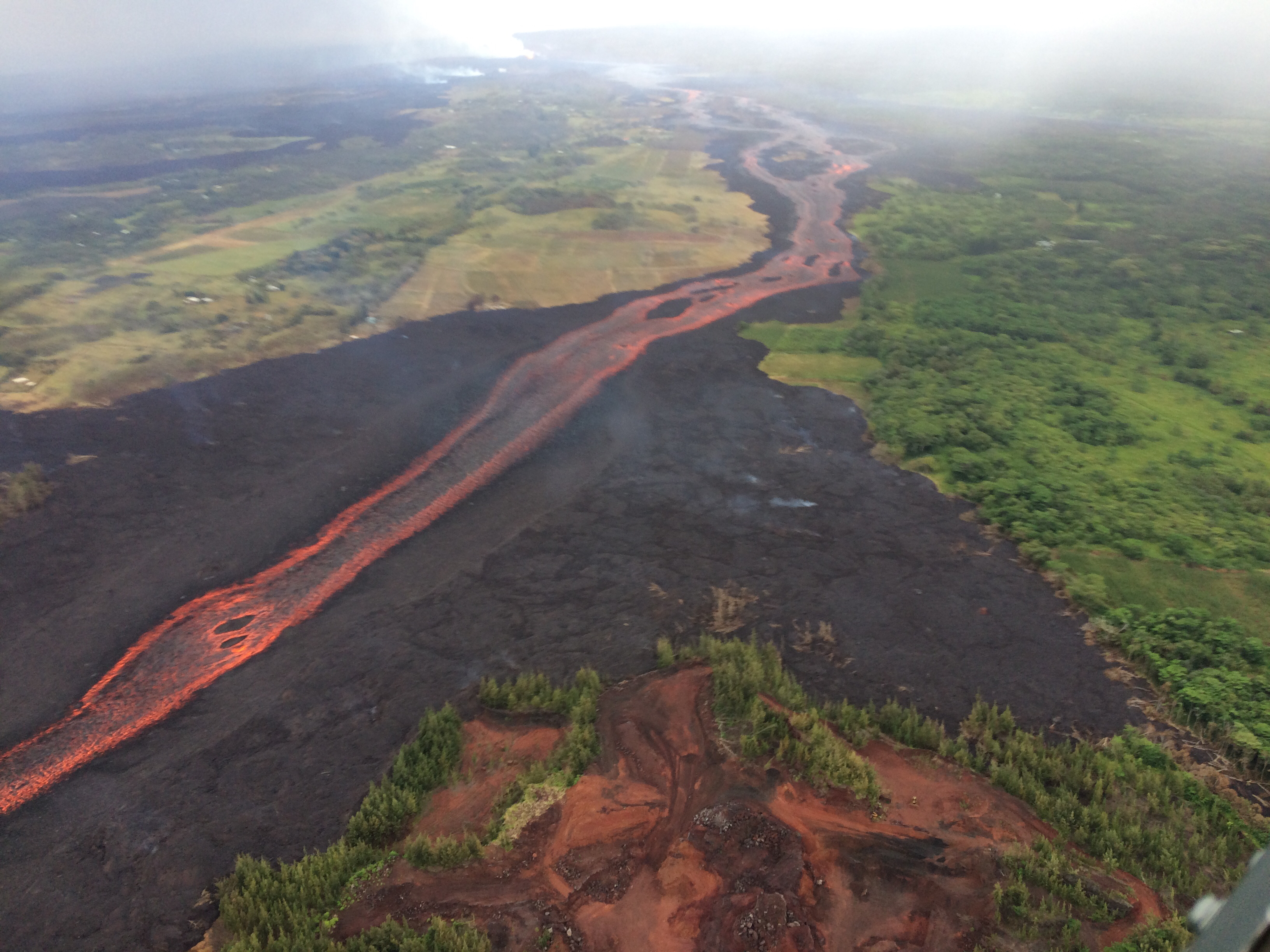
Once again, houses give a sense of scale. That is a thick lava flow, as well as an expansive one.
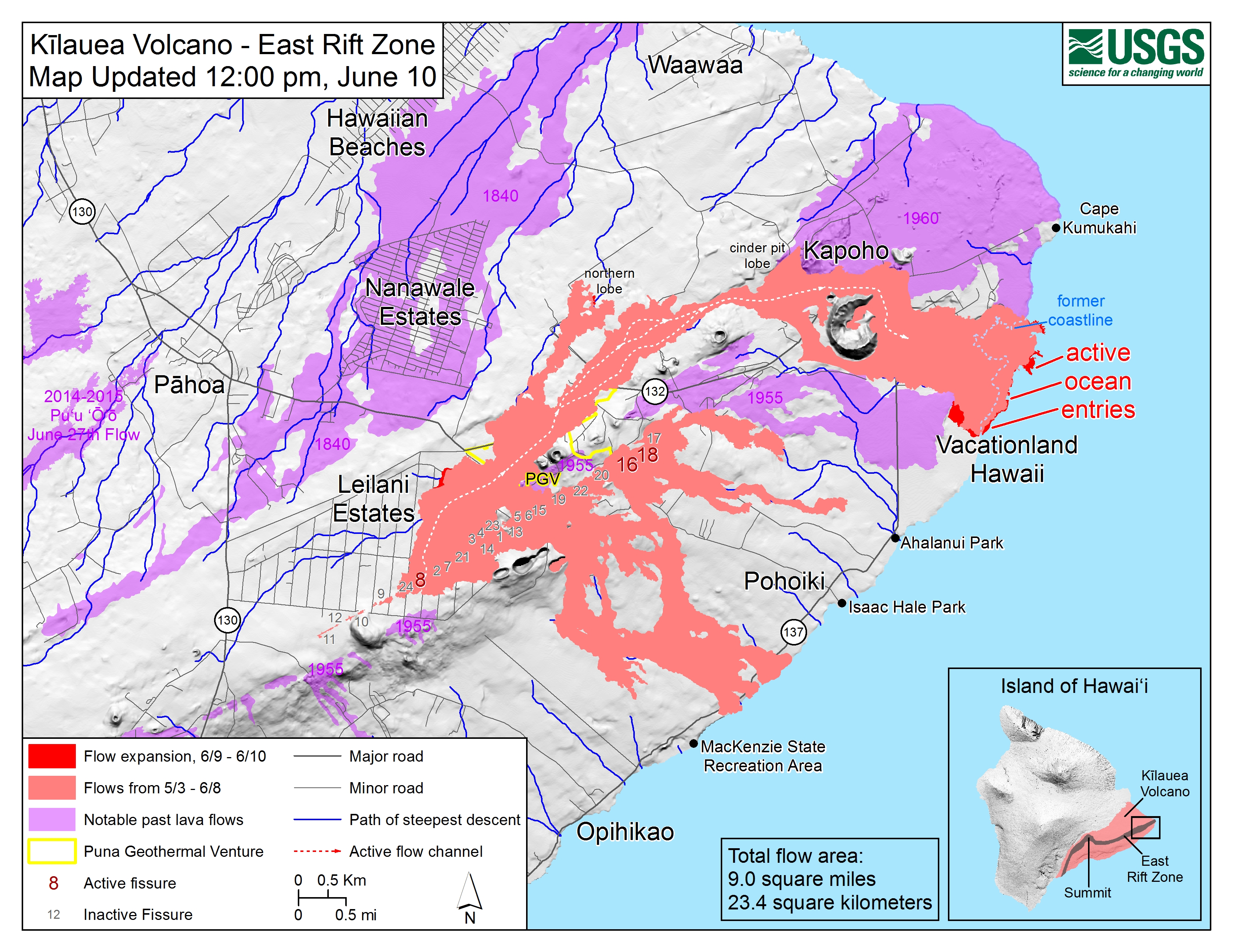
Lava Flow Map: Noon June 10, 2018
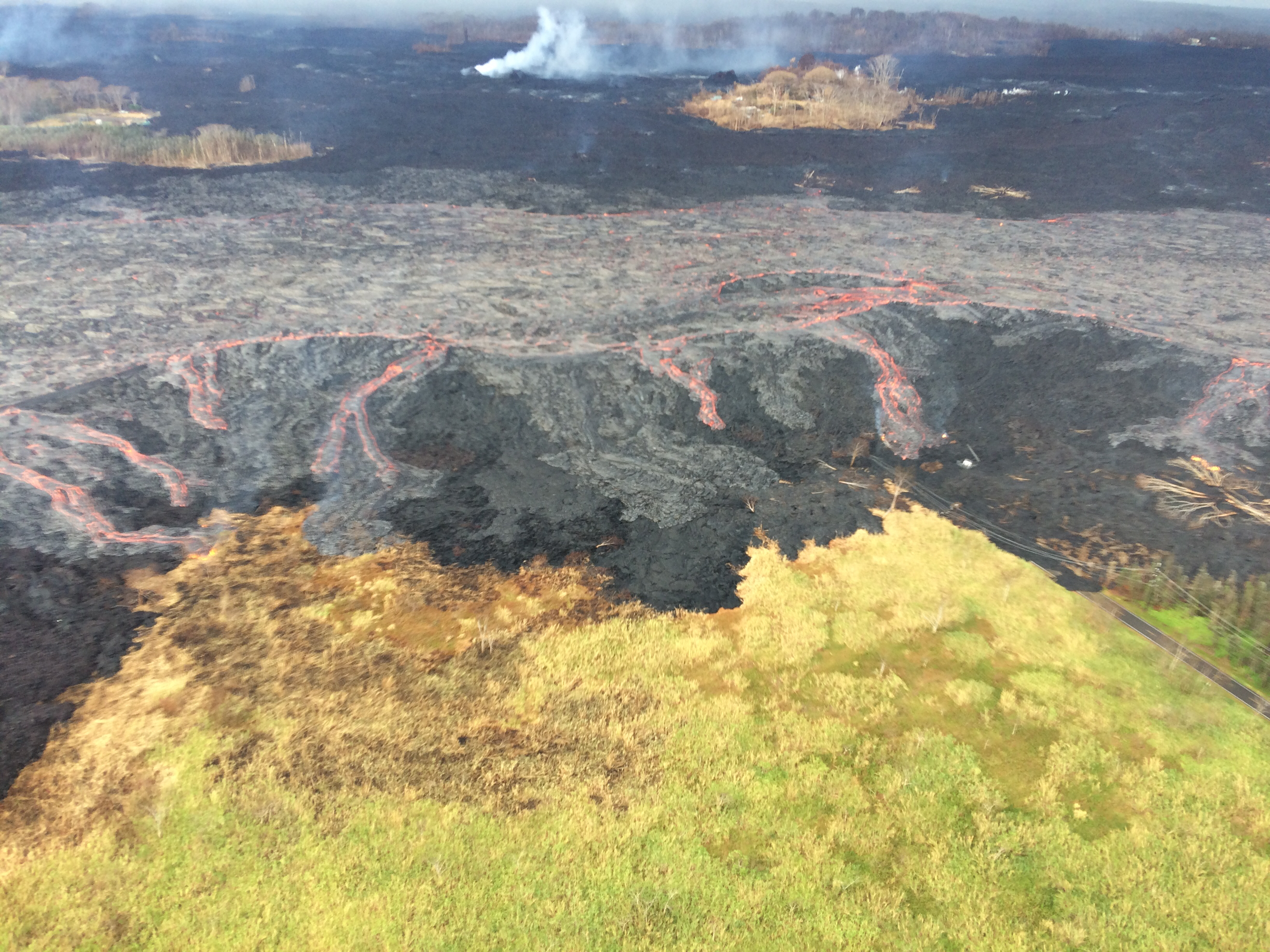
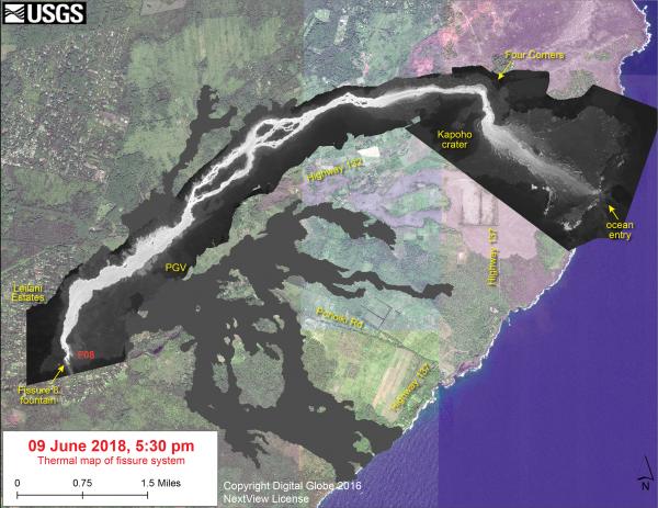
Thermal Map from 5pm yesterday:
My mother remarked how astonishing it is that it’s still white-hot— or at least the temperature’s at the top of the thermal map’s scale— all the way past Kapoho Crater. That’s miles and miles.
Yesterday’s 5pm overflight uploaded this morning
From June 9 late afternoon.
HVO Kilauea 4pm Status update for June 10
No video briefing or conference call today, but HVO’s 4pm status report brings us up to speed. I’m going to quote today’s update in full for a change.
The parts in italics are the parts that change from one status update to the next, and that’s what I’ve been summarizing in my daily posts. I have not been covering the non-italic sections, which tend to remain the same for days or weeks at a time.
Kīlauea Volcano Lower East Rift Zone
Vigorous eruption of lava continues from the lower East Rift Zone (LERZ) fissure system in the area of Leilani Estates.
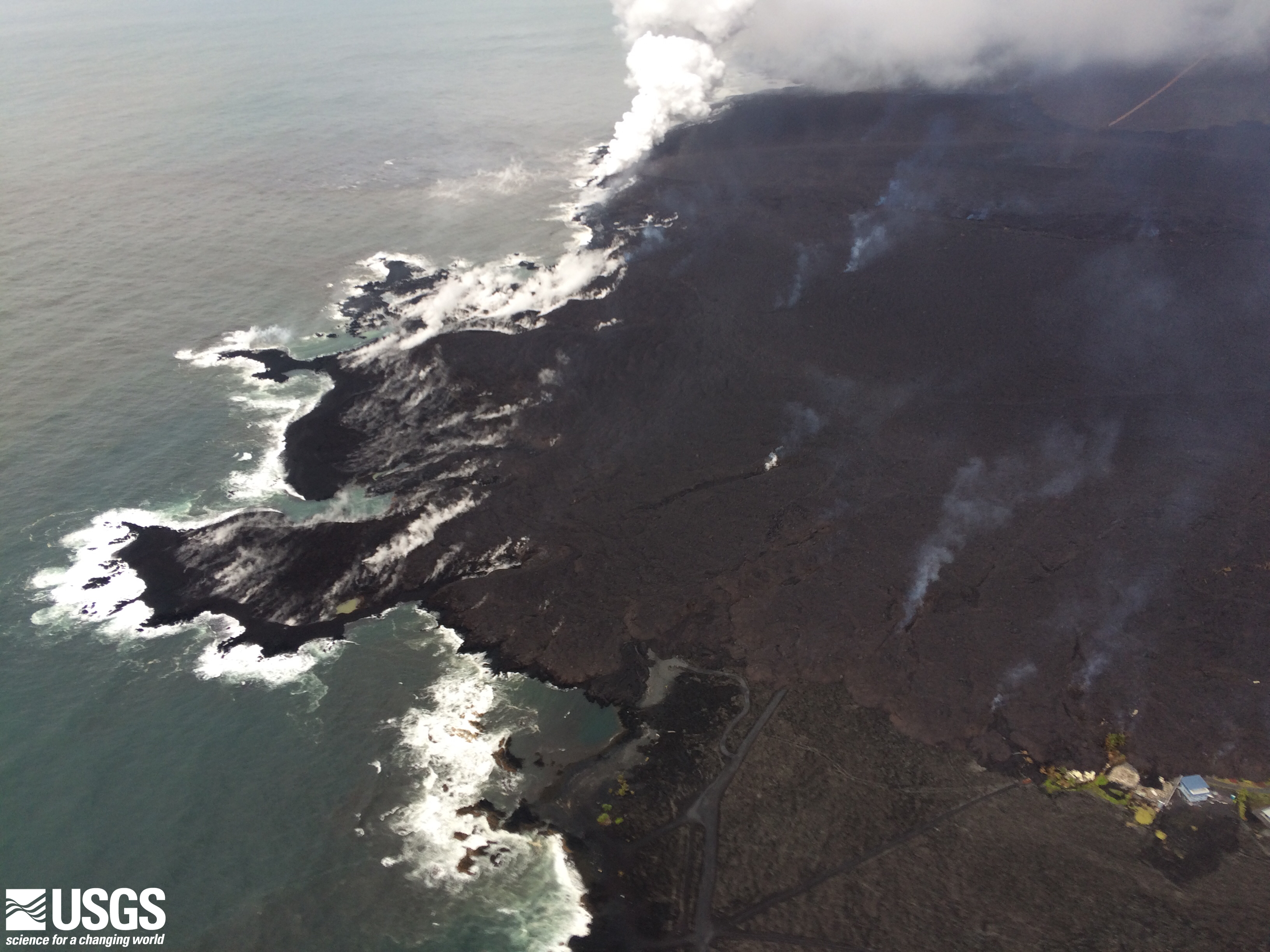
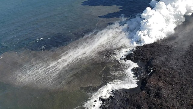
Overnight, lava fountains from Fissure 8 reached heights of 130-180 feet, feeding a strong channel to the northeast and then east that experienced minor small levee overflows. Near the Four Corners region the channel was incandescent and flowing. Yesterday’s measurements show that gas emissions have nearly doubled, possibly indicating an increase in eruption rate from Fissure 8. The morning overflight revealed that the fountains and channels continue to erupt and transport lava to the ocean entry which was one large plume. Offshore of this ocean entry, there is an upwelling of ocean water heated by lava flowing on the ocean floor. Minor lava activity at Fissures 16/18 continued.
Pele’s hair and other lightweight volcanic glass from fountaining of Fissure 8 are falling downwind of the fissure and accumulating on the ground within Leilani Estates. High winds may waft lighter particles to greater distances. Residents are urged to minimize exposure to these volcanic particles, which can cause skin and eye irritation similar to volcanic ash.
The most recent map of lava flows can be found at https://volcanoes.usgs.gov/volcanoes/kilauea/multimedia_maps.html
HVO field crews are on site tracking the fountains, lava flows, and spattering from Fissure 8 as conditions allow and are reporting information to Hawaii County Civil Defense. Observations are also collected on a daily basis from cracks in the area of Highway 130; no changes in temperature, crack width, or gas emissions have been noted for several days.
Volcanic gas emissions remain very high from Fissure 8 eruptions. Yesterday, gas emissions were measured to be nearly twice the value measured during the past two weeks. Trade wind conditions are expected to bring vog to the south and west sides of the Island of Hawaii.
The ocean entry is a hazardous area. Venturing too close to an ocean entry on land or the ocean exposes you to flying debris from sudden explosive interaction between lava and water. Also, the lava delta is unstable because it is built on unconsolidated lava fragments and sand. This loose material can easily be eroded away by surf, causing the new land to become unsupported and slide into the sea. Additionally, the interaction of lava with the ocean creates “laze”, a corrosive seawater plume laden with hydrochloric acid and fine volcanic particles that can irritate the skin, eyes, and lungs.
Magma continues to be supplied to the lower East Rift Zone. Seismicity remains relatively low in the area with numerous small magnitude earthquakes and low amplitude background tremor. Higher amplitude tremor is occasionally being recorded on seismic stations close to the ocean entry.
Additional ground cracking and outbreaks of lava in the area of the active fissures are possible. Residents downslope of the region of fissures should heed all Hawaii County Civil Defense messages and warnings.
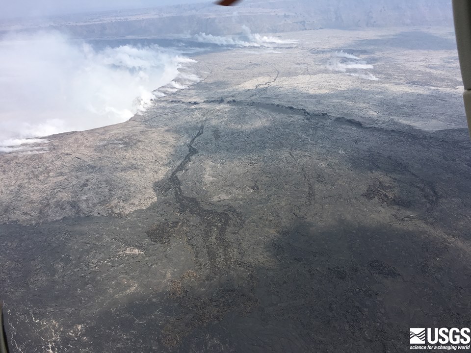
Kīlauea Volcano Summit
A small explosion occurred at Kilauea’s summit at 12:51 AM HST — about 20 hours since the previous event. Seismicity dropped immediately after the explosion and remains low at this time, but based on past trends we expect earthquake rates to increase over the course of the day. Inward slumping of the rim and walls of Halema`uma`u continues in response to ongoing subsidence at the summit.
Sulfur dioxide emissions from the volcano’s summit have dropped to levels that are about half those measured prior to the onset of the current episode of eruptive activity. This gas and minor amounts of ash are being transported downwind, with small bursts of ash and gas accompanying intermittent explosive activity.
For forecasts of where ash would fall under forecast wind conditions, please consult the Ash3D model output here: https://volcanoes.usgs.gov/observatories/hvo/activity_2018.html
Latest Kilauea Status Updates June 10
#HVO #Kilauea update (4:01PM HST June 10): Fissure 8 has 3 closely-spaced fountains. Minor spillovers from channel levees stalled before traveling far. Gas emissions remain very high. No summit ash emissions since dawn, but wind is remobilizing ash. https://t.co/7sDZqcx8dU pic.twitter.com/Om90WKtgtB
— USGS Volcanoes🌋 (@USGSVolcanoes) June 11, 2018
Kīlauea Status Update: 10:26 PM HST June 10, 2018https://t.co/7sDZqcx8dU
No major changes to Fissure 8 flow, Summit seismicity is building and a small explosive event there is expected within hours.
— USGS Volcanoes🌋 (@USGSVolcanoes) June 11, 2018
Civil Defense Updates
The usual. Morning ash warnings for Ka’u following predawn summit explosion, trade winds coming to the rescue for the rest of the Big Island. 6AM | 1PM | 6PM
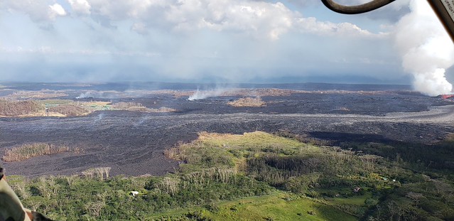
Hawaii County Fire Dpt Photos June 10
Great album of 71 (!!!) detailed Kapoho/Fissure 8 overflight photos and videos posted on the Hawaii Civil Defense Flickr today.
I think that may be PGV on the left in the background:
This video ends by examining that “perched flow” area they’ve been worried about (at least, I assume that’s it):

It’s hard to tell where the edges of the molten areas are during the daytime, since it’s not glowing much.
It’s also hard to tell far out the lava is extending underwater.
Here’s that album’s link again.
HVO/USGS Answering Questions on Social Media
No. Volcano is still Kilauea – fissure 8 is just the active vent on a very active volcano.
— USGS Volcanoes🌋 (@USGSVolcanoes) June 11, 2018
Picture linked to by Dane is a graph of the recent earthquake cycle/pattern at the summit:
The tilt reflects the cycle of explosive eruptions we've been seeing at #Halemaumau: earthquake activity ramping up to an explosion that registers as a M5, with an uptick in tilt as the crater floor lifts, followed by a slow ramping up to the next explosion 24-36 hours later.
— USGS Volcanoes🌋 (@USGSVolcanoes) June 10, 2018
A reminder that the current summit explosions are steam — and maybe gas — explosions whose vibrations register like earthquakes in the same way that shockwaves from a bomb or even ocean waves from a strong storm have a seismic signature without being true earthquakes:
Explosions from the summit release pressure waves that are recorded as earthquakes. The pressure release is equivalent to a M 5.3 earthquake, but it's not a traditional, fault-rupturing earthquake. Still can be felt by people nearby though…just not people far away.
— USGS Volcanoes🌋 (@USGSVolcanoes) June 11, 2018
I’ve been wondering exactly what is exploding up there. In 1924, scientists guessed they were steam explosions, but it wasn’t until now, with modern instruments available, that the USGS can begin to measure and analyze Kilauea summit explosions.
We are definitely in discussion about summit eruption mechanisms. There is a lot more science to be done. A primary need is to analyze details of ash samples. We *do* see gases derived from magma, in addition to water vapor, at the summit. So, yes…questions yet to be answered.
— USGS Volcanoes🌋 (@USGSVolcanoes) June 11, 2018
But I imagine they’re having to priorities fieldwork in the Lower East Rift Zone over the summit, since it’s closer to more people. Although they’re also having problems getting samples— no wonder, since the main lava channel has huge barely-solidified banks they dare not climb:
We don't know, but it probably isn't a lot. We have seen geochemical signatures of #PuuOo lava already, and possibly some of the summit lava, but it has been difficult to collect samples lately. We just collected one this morning, so we should have a better idea soon.
— USGS Volcanoes🌋 (@USGSVolcanoes) June 10, 2018
We don't, which is what makes volume estimates difficult. We can make a guess based on where the ground surface used to be, but only that!
— USGS Volcanoes🌋 (@USGSVolcanoes) June 10, 2018
Also, I got an answer to a question about Pu’u O’o I’ve been wondering about since May 2!
At #PuuOo, the walls have had collapses, but for the most part rock that was being oxidized by the activity before the draining event is still sitting there. At #Halemaumau, the enlargement of the crater means that new, unoxidized rock is falling and being erupted in the plume.
— USGS Volcanoes🌋 (@USGSVolcanoes) June 10, 2018
From Other Scientists
- Weatherboy Meteorology Blog: “Flash Flood of Lava Possible“
- Dr. Michael Poland, GSA Today, “The 2014-2015 Pahoa lava flow crisis at Kilauea Volcano, Hawai’i: Disaster avoided and lessons learned”
- Nice profile of Dr. Michael Poland (USGS): “The Scientist Calming Us Down During Volcanic Eruptions”
- ImageGeo blog, Discover: “Nearly two decades of revealing satellite images now available at your fingertips” Here’s May 7, 2018 focused on Hawaii: is that a plume over Halema’uma’u? And here it is in 2010.
Mick Kalber Daily Overflight
Here’s his notes for today.
From Local News Outlets
- Recommended read:
HSA: “Kilauea eruption will fuel volcano research for years to come” – good quotes and tidbits from the USGS scientists we’ve been getting to know - Lower East Rift Zone Eruption:
HSA: “Fissure 8 dominates eruption with lava fountains, flows” - Human impact:
BIVN: (5-minute video): “University of Hawaii Contributes To Eruption Response”
KITV: “Lava evacuees cited for lack of camping permits”
HTH: “National park’s closure, drop in visitors hurt Volcano businesses”
HSA: “Photos and words fall short in describing volcano”
Featured Photographer:
G. Brad Lewis, volcanoman.com
. Thanks to @Cheaptarts for pointing me to BradLewis Instagram. I’ve seen Mileka Lincoln post his great photos, but I prefer to embed from the original photographer’s social media so he retains control of the source file.
See more on GBradLewis’ Instagram.
More Social Media
Amazing colors.
Hardened lava on section of Highway 132, about 1.5 miles away from the fountaining Fissure 8 at Kilauea’s Lower East Rift Zone @StarAdvertiser pic.twitter.com/q4koZbASgG
— Rosemarie Bernardo (@RoseBernardo) June 10, 2018
From the nerd side of Twitter, trying to suss out these summit explosions:
Kilauea summit seismicity graph: updated & with more info! Red circles for "volcanic eruption"/explosion events, summit quakes shown both in blue & in grey background histogram: after each explosion, faults in caldera area are less stressed &, therefore, produce fewer quakes pic.twitter.com/6SAQiIxPOK
— Jascha Polet (@CPPGeophysics) June 10, 2018
(I’ve seen the above graph used by the “Mauna Loa’s about to erupt!” hoaxsters, with the “Kilauea Summit Events” caption erased. Sigh.)
Yeah, look at the time between earthquakes. Interesting. pic.twitter.com/iy9IIz2HGK
— Wesley Snyder (@365DaysOfDisney) June 10, 2018
Find some hot rocks to lay on & the summit will give you a great massage. #halemaumau #Hawaii #hvnp #hppa #volcano #Kilauea #lava #NEWSで妄想 #KilaueaVolcano #LeilaniEstates #BigIsland #eruption #Kapoho #Sundaynight pic.twitter.com/f1CcmvXpbL
— lavapix.com (@lavapixcom) June 11, 2018
And now, several tweets memorializing Kapoho Bay.
360 degree interactive video from the shore off Alapai Point as lava initially reached the ocean in Kapoho Bay. Huge laze plume. #Kapohobay #Kilauea (Look in different directions on a mobile, drag and drop on PC)https://t.co/7rd1HX2FDA
— Dane duPont (@GeoGolfHawaii) June 11, 2018
Someday, there will be new tidepools, but it will take a long time in human years.
#KAPOHO Here's beauty that sat in front of those few homes that were remaining as of yesterday (remain still?), an oceanside nature walk bordering the lava beach. I will miss these walks! #Kapoho #puna #Punastrong #Hawaii #Kilauea #lava #Pele #GoddessPele #CannotOwnEarth pic.twitter.com/8NSTOdPMMo
— Kat Caric (@KatCaric) June 10, 2018
I added a video to a @YouTube playlist https://t.co/3oyOl6j0UK Mavic 4K #08 Hawaii: KAPOHO – The Tide Pool
— Kimberly Denise M-M (@berlydmm_kim) June 11, 2018
So sad. This beautiful home, its tide pools, even the sea tortoises were destroyed and covered with lava. Kapoho Bay Oceanfront Hawaiian Sanctuary – MLS 603282 https://t.co/jUlvVaoEDI via @YouTube
— Gort (@DrugstorCowboy) June 11, 2018
Spending Time at the Kapoho Tide Pools: https://t.co/kkrS8usO1F
— Odywan@sbcglobal.net (@Odywansbcglobal) June 11, 2018
Sadly, while people can get out of the way and rebuild, many animals were left behind. Volunteers (including the indefatigable Ikaika Marzo) are mobilizing to rescue animals cut off by flows south of Kapoho Bay, where there’s still ocean access. But this is particularly sad:
Animal rescue volunteers reporting a large # of abandoned dogs & other pets trapped here on Green Mountain, surrounded by lava flows. Many were forced to abruptly evacuate #Kapoho & didn't have enough time to round up their animals. Looks like pets came here when lava arrived. pic.twitter.com/LNUikbOpKh
— the Weatherboy (@theWeatherboy) June 10, 2018
Heartbreaking. But it sounds like there’s some very determined people trying to save them:
6/10/18 WE ALL NEED TO PUT PRESSURE ON COUNTY AND CIVIL DEFENSE RE:ANIMAL RESCUES. This is beyond URGENT!!! Axel Kratel…
Posted by Liz Gilbert on Sunday, June 10, 2018
I really, really hope this happens.
(I don’t know this group, nor have they landed on GoFundMe’s verified page so far. But from what I’ve seen, they appear to be compassionate locals speaking in good faith.)
In the meantime, to avoid even more animals being left behind if the lava heads in a new direction (these areas are not yet threatened, but they’re close enough to the Fissure 8 flow they could be, if there’s a major breakout):
Those in #NanawaleEstates & #LeilaniEstates should use the "luxury" of time & advance warning to properly prepare for potential #KilaueaEruption evacuation. Also have a plan for your pets! Prepare now so you don't scramble later. Stay safe!
— the Weatherboy (@theWeatherboy) June 11, 2018
More beautiful images, sober pictures, and glimmers of hope from the Puna community coming together to help one another:
6/10/18 From the wonderful Monica Berger " Yesterdayʻs fly over. There are not enough adjectives to describe these…
Posted by Liz Gilbert on Sunday, June 10, 2018
I can’t end this post on such a grim note.
This is a local account of the last Kapoho to be buried by lava, but it also tells of regrowth/rebirth after the lava cools:
Gladys Flanders, published in “Honolulu” magazine, 1985:
“Our Volcanic History — in 1959” an account of the last Kapoho community to have to face this kind of loss and rebuild:
Today, 25 years after the eruption, many of the townspeople, including Joseph Pestrella, Koichi Soga and Masakichi Higashi, are dead. Others, like Shizuka Inada, live in Hilo. But most followed their original plan to settle in the Pahoa area. Here they raise papayas or grow anthuriums beneath lush tree ferns. Since 1961, the Lymans’ Kapoho Land and Development Company has been reclaiming Kapoho’s cinder-covered wasteland, and more than 55 acres are covered with flourishing papaya and ornamental shrubbery, grown on an experimental basis.
White lichen, known as “Hawaiian snow”, has begun to creep across the clinkery lava bounding the hiking trail that starts near the site of Kapoho, at the foot of the cinder cone Pu’u Laimanu. There is an easy, but slippery, walk to the cone’s rim. Toward the ocean, in the direction the lava took, is the junction of routes 132 and 137. On the left is a small cemetery, one of the few spots spared by the lava. The lighthouse at the end of the trail is now automated.
Eerie silence pervades the vast area of twisted lava. In the mist one senses the presence of Alice Campbell’s visionary Pele, moving on soundless feet, her long black hair flowing in the wind.