Video Clips: Pāhoehoe vs A’a (What’s the Difference?)

If you’ve followed this blog at all, you’ve come across the terms “pāhoehoe” and “a’a.” They’re Hawaiian words borrowed by volcanologists as technical terms for different types of lava. How can you tell which is which?

When I visited in 1986, the joke was that “a’a” is the noise you make when you walk on it, because it’s prickly, and “pāhoehoe” is the smooth stuff. But that’s oversimplified, and it confused me. Some of the old pāhoehoe flows we hiked on near Mauna Ulu seemed pretty bumpy to me.

Pāhoehoe lava is runny, faster-moving, and often described as “ropey.” It’s pretty obvious when it’s spilling into a crater or running swiftly in a river. Sometimes it has ripple marks. At other times, the leading edge slows down and turns blobby. Here’s an excellent USGS video of a pahoehoe front in night and day, May 24-25:

Pāhoehoe moves forward by inflating lobes of lava with fresh new lava from within.

Then there’s a’a lava: a crumbly, chunky mass of what looks like a heap of rocks and gravel and dirt, except it’s red-hot under the outer skin. It moves like a horizontal landslide in slow motion, bulldozing everything in its path:

It advances mostly by chunks tumbling forward off the front.

A’a is usually quite slow. You can outwalk it. In fact, you’d usually have time to pack a small suitcase if it showed up at the end of your street. Whereas when pāhoehoe flows downhill or becomes “channelized,” making itself a smooth chute, you can’t outrun it:

Both kind of lava make crinkly noises, but I think of a’a as “clinkity clankity” lava, whereas pāhoehoe tends to slither.

So now you’ll know how to explain it the next time someone asks, “What’s the difference between pāhoehoe and a’a?”

May 26: Lava Turns Towards PGV

Puna residents watch with a sinking feeling of “I told you so” as a ponderous a’a flow crossed Pahoa Pohoiki Road slightly north of the geothermal plant, inching towards it. Officials think they’ve got the wells quenched  (I notice they quietly dropped the idea of plugging them), and that they’re safe.

Hawaii County photo looking south across Pohoiki Road, geothermal plant bottom left. Photo not timestamped but probably around noon. “Fissures 7 and 21 are feeding an ‘a’ā flow that has advanced to the northeast and this afternoon crossed Pahoa Pohoiki Road onto PGV property, USGS reported.”

Meanwhile, Fissure 7 is causing trouble in all directions; its lava pond has sent another flow “cascading into Pawaii crater” (6:15pm).  Looking at the map, I’m betting that crater is an old vent from a previous fissure eruption just like this one. In addition to fluid/runny pahoehoe flows, some of the longer flows are a’a.

The summit has also been busy today, with three ash explosions reaching the ~10,000 foot height between midnight and dawn, and some reaching “as high as 12-13K‘ [above sea level]” this morning. Reminder: Kilauea is 4009 feet above sea level (asl).

Moving on. I’ve gotten in the habit of checking the Lower East Rift Zone webcam last thing before I post:

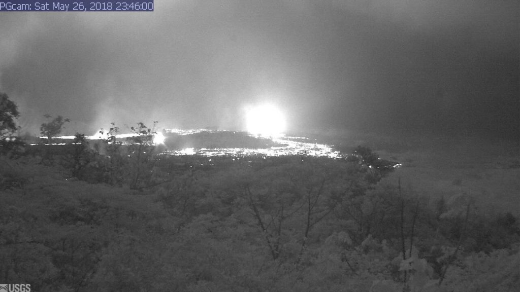
USGS webcam of LERZ. Grabbed just before midnight, May 26. Is that a lava flow coming towards the camera?

Next image on the LERZ webcam.

I do believe it is. Has that lava pond broken loose?

Lava tally as of Saturday morning: 41 houses, 82 structures total. A further 37 homes isolated by lava crossing roads. Lava has covered 3.7 square miles/2372 acres so far.

Here’s the usual roundup of the day’s eruption news, astonishing views, and geeky info by geologists:

Continue reading May 26: Lava Turns Towards PGV

May 26: Good Morning, Hawai’i

Strange that something so disruptive can be so beautiful.

Hawaii Volcano Observatory Alert: Saturday at 5AM, the summit crater let off a series of explosions at 5AM sending up an ash cloud 11,000 feet that lingered for 25 minutes. Lighter winds may keep ashfall from today’s explosions mostly within the park, giving downwind communities a respite. [Edit: No such luck. Taller ash explosions today had more range.]

HVO webcam caught a nice glimpse of plume by moonlight (“exit” sign of observatory reflected in lens):

(Camera is picking up a few lights from observatory; note “Exit” sign.)

Sadly, it was not so tranquil-looking down in Leilani Estates, 25 miles away:

May 25: End of the Road for Leilani Estates?

It looks like the coup de grace for Leilani Estates, or at least its eastern part.

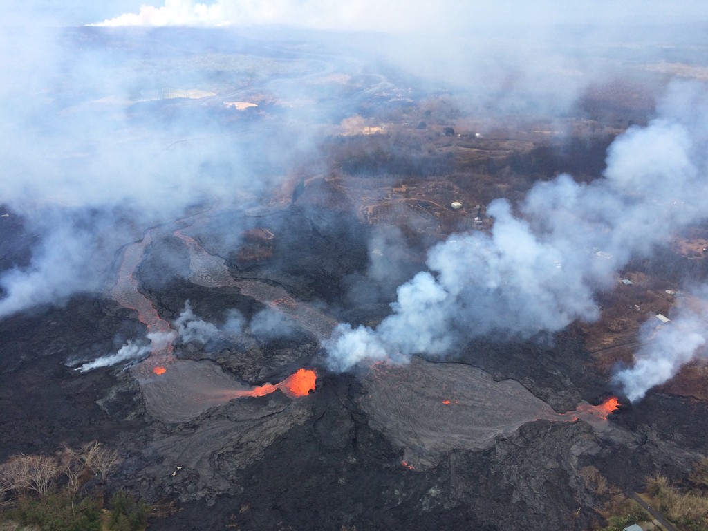
USG Photo, May 25, noon overflight. Fissures 6 (left) and 13 (right) send lava flows south that join and flow down to ocean (white laze plume in distance). Note metal roof(?) embedded in lava at lower left. [Full-sized]
Three weeks ago Leilani’s streets were lacerated by fissures, battered by lava spattering from cracks, and blocked off by ponderous flows that seldom traveled far from their source. But that was a slow-motion disaster. Most fissures were active only a few hours. While a few unlucky residents lost homes in the first wave, most were able to return and collect vital possessions, or even risked dangerous fumes to stay.

Last week, the main lava activity shifted east, downrift, overrunning smaller Lanipuna Gardens, threatening the PGV geothermal plant, and inundating fields and woods where homes were more scattered.  “Hotter, fresher” magma arrived last Thursday with a roar, spurting in several-hundred foot fountains and flooding forests with rivers of fast-moving pahoehoe lava. On Saturday night, these channels reached the ocean.

It was only a reprieve. A few days ago, the fissures that had given Leilani grief began reactivating. The group of fountains monitored by HCB’s livestream began to subside as uprift vents pilfered their magma supply.  Leilani’s reinvigorated vents poured out so much lava they created a pond, as well as sending new flows down to the sea. And through people’s houses:

Today, more streets were buried. Firefighters went door-to-door urging the last holdouts to flee before lava reaches them. Even parts of lower Puna not yet menaced by lava were ordered to leave before their remaining escape routes are cut off. Just in case, authorities have sent in the Marines.

82 structures lost. A two mile stretch of fissures in a residential area is pouring out an astonishing 40-60 cubit feet per second. And yet only 3.4 square miles have been covered by lava in this eruption, on an island of over 4000 square miles. But that doesn’t make it any easier for those affected.

Below, a roundup of Friday’s images, videos, USGS news, and reports from local news stations.

Continue reading May 25: End of the Road for Leilani Estates?

May 24: USGS Acquires Drones, Leilani Estates Acquires Lava Lake

Before this, the main thing USGS was using drones for was LIDAR, but today’s Photo & Multimedia entry on HVO’s website provides drone footage for both the summit steam/ash plume and Leilani/Puna lava flows.

SUMMIT ERUPTION:

This video was filmed on May 21, 2018, with a UAV (unmanned aerial vehicle). Limited UAV flights above the hazardous Kīlauea summit area, which is currently too dangerous for geologists to enter for ground observations, are conducted with permission from the National Park Service. […] At Kīlauea Volcano’s summit, a nearly continuous plume of gas and steam billows out of the Overlook vent and drifts with the wind. Explosions are occurring about two times a day, producing ash that rises to a height of between 8,000 to 10,000 feet above sea level. Small ash emissions occur more frequently. The larger explosions produce ash that is blown downwind, and trace amounts have fallen in nearby communities.

Addendum: there was a 6PM 10,000 foot ash explosion & plume this evening (Civil Defense photo, USGS video), sending ash southwest.

PUNA LAVA ERUPTION:

This footage is from an Unmanned Aircraft System (UAS) hovering near fissure 22 during the overnight hours of May 22, 2018, and looking down on the fountaining fissure complex. The view rotates upward (to the south) to track channelized lava as it flows toward the Pacific Ocean, about 3 mi (5 km) away. The ocean entry is in the distance, recognizable by a small plume. The USGS National Unmanned Aircraft Systems Project Office is assisting with remote data collection and mapping of lava flows and hazards…

HVO’s Photo & Multimedia blog also posted impressive Hilo Civil Air Patrol aerial photos of the lava rivers from yesterday, as well as an image of Fissure 22 taking a nap (it’s still going but lower today on Civil Beat’s Livestream) while the fissures west of it (and uprift) that activated yesterday inundated Leilani Estates.

As an aside: people keep posting ridiculous rumors, so the USGS had to reassure everybody that Mauna Loa is NOT erupting.

Latest video this evening from HNN reporter Mileka Lincoln:

Earlier in the day… welcome to the Leilani Estates Lava lake. (warning: noisy)

The residents are being absolute champs in coping with this. Here’s another video clip of the lava lake with the homeowner whose home is just outside of it. They’re very philosophical, realizing they took a gamble, which is more mature than some of the people criticizing them for taking a chance on a place that hasn’t had an eruption in about 60 years. And they’re helping one another.

Oh, my mistake. It’s a lava pond.

Mick Kalber’s helicopter overflight video today does a great job of showing the “pond,” the fissures headed from there past the geothermal plant, and the lava rivers flowing south from those fissures towards the ocea.

USGS Updates, News Roundup, And More Vivid Videos:

Continue reading May 24: USGS Acquires Drones, Leilani Estates Acquires Lava Lake

Pele’s Path: Eyewitness to History

HawaiiNewsNow has had the most in-depth and on-the-ground local coverage. Wednesday night they aired a half-hour documentary, Pele’s Path: Eyewitness to History.

Hawaii News Now – KGMB and KHNL

It’s a day by day look at how this has unfolded for the shaken residents of Puna, for the state officials scrambling to address this fast-moving crisis, and for those who are front-row witnesses to the power of nature at its most destructive… and yet beautiful.

May 23: Blue Flames? Now You’re Just Showing Off

Kilauea’s chief resident has found another way to amaze and/or injure people reckless enough to get too close to her redecorating:

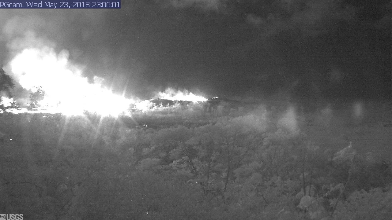
I had a hunch the Lower East Rift Zone webcam would be interesting tonight. I wasn’t disappointed:

I see what they mean about the Leilani fissures further west (uprift, towards the camera) reactivating today.

Edited to add: Yikes.

It’s 11:06 PM in Hawaii; second screengrab an hour or so later.

I was about to hit post, when I saw erstwhile reporter Mileka Lincoln and her crew posted this. Wow.

(recorded just an hour ago at time of this post.)

Now, let’s have the evening roundup of poignant news, amazing views, and interesting science…

Continue reading May 23: Blue Flames? Now You’re Just Showing Off

May 23: USGS Presentation on Puna Lava Eruption So Far

Tuesday evening, USGS Volcanologist Steve Brantley gave a  presentation in Pahoa High School. A lot of it is fairly simple, recapping the eruption for residents of Puna. I’ve covered most of what he does in previous posts. But there are a few new tidbits.

His takeaway is worth seeing if you don’t read/watch the rest:

…until that balance is reached, or something else changes, we expect magma to continue moving from the summit reservoir into the rift zone and further down into the Lower East Rift Zone. So that suggests that we’re in it for the long haul. We don’t know how long this eruption’s going to last, but for now, it looks like it’s just going to continue.

Full transcript below the cut.

Continue reading May 23: USGS Presentation on Puna Lava Eruption So Far

May 23 – Beware of Falling Rock

I’m still wondering, and there’s absolutely no way to know: will this follow the pattern of the 1955 Kapoho eruption in whose footsteps it’s following? (Same general area, and in fact for the first two weeks that slow-moving lava coming out was mostly 1955’s leftovers.)

“The [Kapoho] eruption lasted for 88 days and opened at least 24 separate vents that stretched nine miles from Kapoho to west of the Pāhoa-Kalapana road. Numerous lava flows cut all access to lower Puna covering over six miles of public roads. The eruption required the evacuation of most coastline residents from Kapoho to Kalapana for an extended period.”—USGS

A few months is a major disruption to daily life, but that’s really not too long before residents can start picking up the pieces.

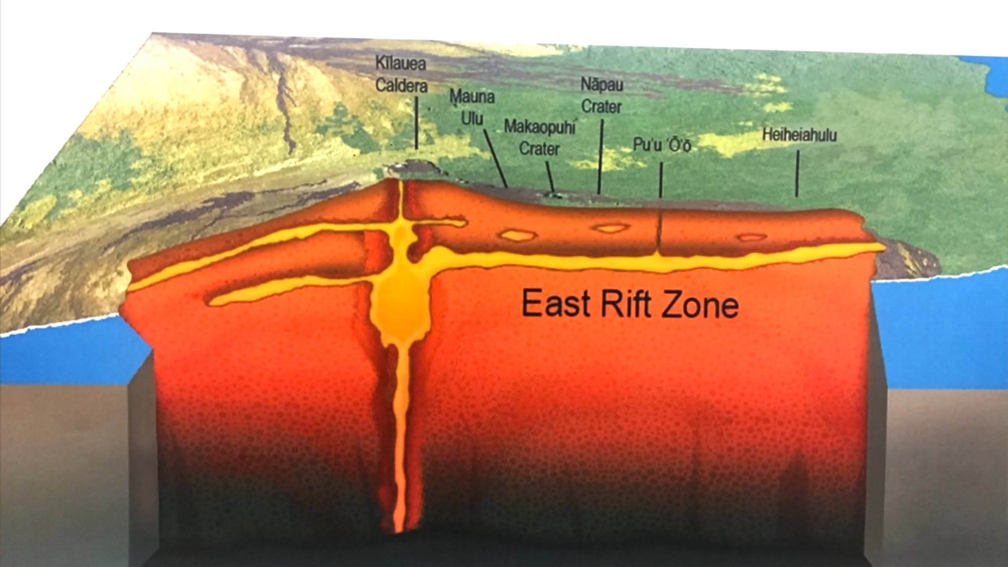
Here’s the thing. This lava came down the East Rift Zone after the bottom of Pu’u O’o Crater collapsed and all its lava drained away. And that unusually long-lasting eruption had been going since 1983. If this is the same magma from the same source, just emerging from a different location, it could go for years.

P.S.. from the HVO website: “Kilauea – 2018-05-23 04:37:34
Another small summit explosion at 10:18 UTC / 00:18 HST 23 May.” Every night, another poof or two. I feel for the people downwind; while ash isn’t as destructive as lava, it’s still disruptive, bad for plants and machinery, and especially hard on people with respiratory issues.

May 22: Late Night News Roundup – More PGV Worries


First of all, Honolulu Civil Beat posted a video of Fissure 22 while his livestream cam  showcases the Fissure 20 complex.

Not that it really matters which is which, but I like to know what I’m looking at. 22 is sending lava down to the ocean (and the geothermal plant.)

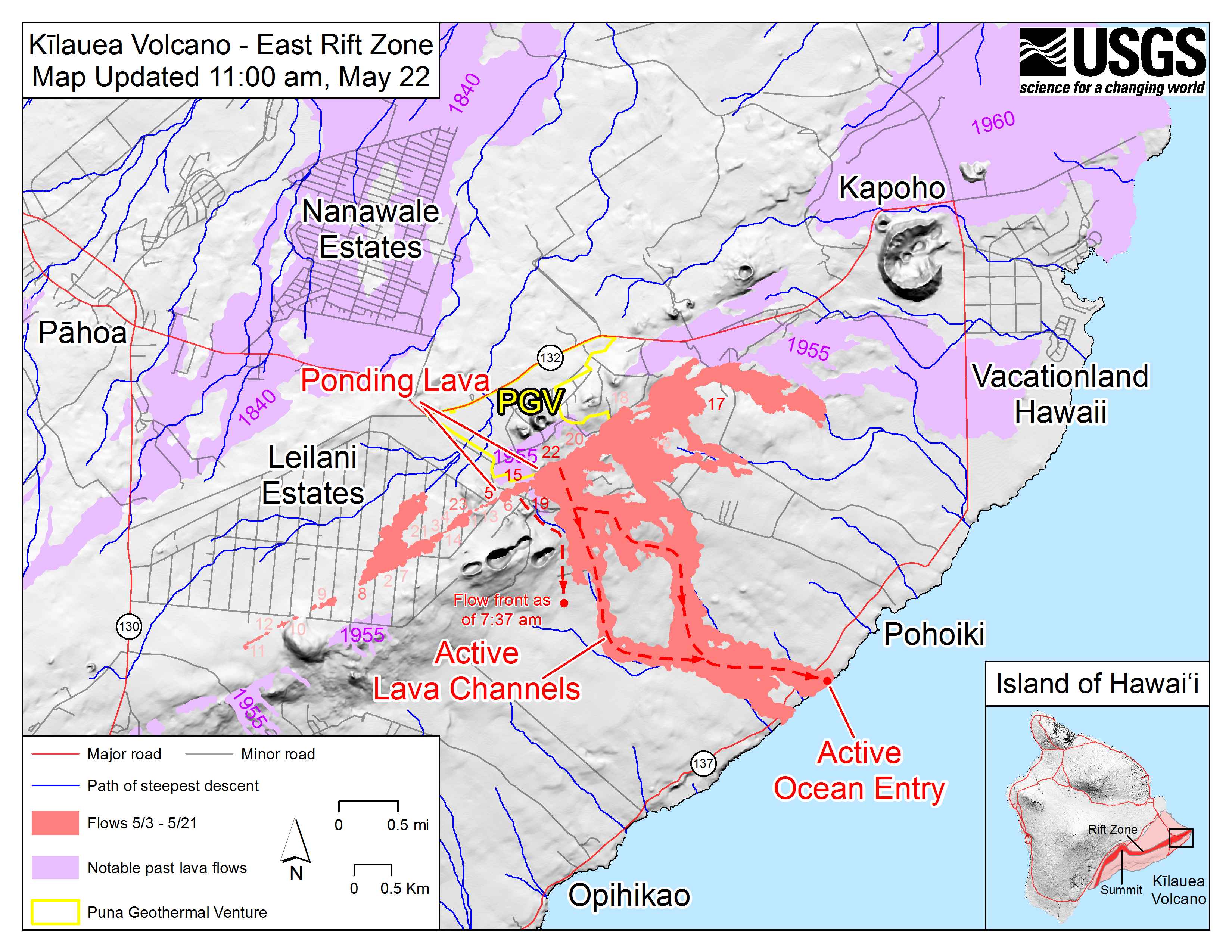
May 22 East Rift Zone Fissure Map by USGS

I think the livestream house is on that raised bump to the right of “PGV,” with the camera pointed SE. I guess this map was devised when 20 was having a low spell earlier today.

Mick Kalber’s usual stunning flyover vid including rivers of lava and lava flows meeting the sea:

Okay, now that we know where we are, what’s happening? Good images, clips and news tidbits after the cut. The main story today was concerns about lava encroaching on the PGV geothermal plant, and the hazards it poses. But first…

Continue reading May 22: Late Night News Roundup – More PGV Worries