Quick Summary of 2018 Kīlauea Eruption

In May 2018, Kilauea Volcano sprung a leak.

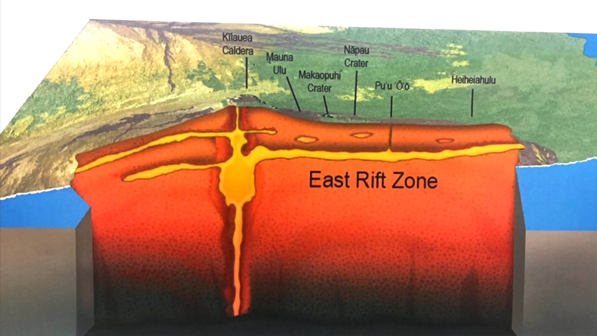
For a decade before that, there had been an active lava lake at its summit, nestled inside Halemaʻumaʻu Crater inside a larger caldera. There was also a side vent on the volcano’s shoulder, Puʻu ʻŌʻō, erupting lava for 35 years.

On April 30, the pipes burst under Puʻu ʻŌʻō. All the lava from it and the summit lava lake drained down a “rift zone” (faults and cracks) to a residential area 25 miles away, on the southeast tip of the island. Lava started erupting in the Lower East Rift Zone (LERZ) on May 3, and continued through early August.

With all that magma (lava when it’s underground) draining away from the summit of the volcano, Halemaʻumaʻu Crater fell in, and the larger caldera around it sank hundreds of feet as well, revealing sulfur banks and other features not seen since Mark Twain visited in the 1800s. These changes didn’t happen all at once, but in stages. During July there were almost daily collapses with shaking equivalent to an M5.3 earthquake (see my video archive).

For a video summary of this eruption and those that preceded it, see this excellent 10-minute history of Kilauea’s eruptions.

This blog is a record of the 2018 Kīlauea eruption, with photos, videos, and info from scientists who study it. I posted daily for the first three months of the eruption, and switched to weekly after the lava in the LERZ stopped gushing and the summit stopped collapsing in on itself.

There’s still a little activity— this volcano almost never goes completely quiet— but for now, residents are holding their breath to see if this eruption is really and truly over.

Pu’u O’o 1983 versus Puna Eruption 2018

I came across this interesting paper on the last lava flow to threaten Lower Puna, just 3-4 years ago. It brings home just how remarkable the current eruption is.

Michael Poland, USGS: “The 2014–2015 Pāhoa lava flow crisis at Kīlauea Volcano, Hawai‘i: Disaster avoided and lessons learned” (Feb 2016)

[Video: Pu’u O’o lava flow 2014-2015]

Poland’s paper says that the Pu’u O’o lava flow (Episode 61e) that started June 27, 2014 was the longest at Kilauea in the past 500 years.* It eventually reached a length of ~20 km (12.43 miles), but it took until March 2015 to get there. Its average rate of speed was 0-500 meters a day.

By contrast, Fissure 8’s current flow started on May 26, 2018, and covered 13 km (8 miles) to the ocean by the evening of June 3 (eight days). At times it exceeded 500 meters per hour. 

This explains a lot.

I wondered why some residents of the Kapoho area said their evacuation orders came with “no warning,” or they didn’t bother to evacuate their belongings, or they didn’t think the lava would reach their house, even though the eruption had started a month before, and lava had been moving their way for a week.

But they’re used to the Pu’u O’o eruption of the past 35 years, which took years and years to reach and cover the community of Kalapana. The current eruption is covering as much ground in a week as Pu’u O’o took months to cover. And Pu’u O’o was traveling farther than any eruption in 500 years.

No wonder people were caught flat-footed!

Below: I created an animation of 3 HVO/USGS maps to show Pu’u O’o vs current Lower East Rift Zone lava flows.

Maps used to create this animation:

  1. USGS April 30 map of Pu’u O’o active lava flow (pink, Episode 61g, May 24, 2016-Apr 30, 2018) and older Pu’u O’o flows (gray, Jan 3, 1983-Apr 30, 2018)
  2. USGS May 2 map showing  magma was moving into Lower East Rift Zone (inferred by earthquakes); Pu’u O’o lava flows of past 35 years shown in pale pink, episode 61g in dark pink. The 2014-2015 (episode 61e) flow is the light Y-shaped area extending to the northeast. (Sorry, I don’t have acreage numbers for episode 61g, or for that matter final totals for the Pu’u O’o lava flows.)
  3. USGS June 10 map of active lava flows in Puna (Lower East Rift Zone) since May 3, 2018, with current flows in pink and historical flows (including the 2014 Pu’u O’o mentioned in that paper) in purple.

In short, the current 2018 eruption is hotter, faster, and covering so much ground that it’s surprising even to geologists, let alone residents. This is not the kind of volcanic eruption they’re used to.

*(Pu’u O’o’s 35-year eruption was exceeded by the 60-year Ailā‘au eruption that created the Thurston Lava Tube in the 1400s. After which, Kilauea caldera collapsed, and there were 300 years of explosive eruptions before Kilauea reverted to effusive (lava) eruptions. But don’t panic: we’re nowhere near 60 years of continuous lava flows even now. Also, two weeks ago the USGS said that only about 2% of the volume of magma in Kilauea’s magma chamber has erupted since May 3, and it’s still being resupplied from below.)


Video Clips: Pāhoehoe vs A’a (What’s the Difference?)

If you’ve followed this blog at all, you’ve come across the terms “pāhoehoe” and “a’a.” They’re Hawaiian words borrowed by volcanologists as technical terms for different types of lava. How can you tell which is which?

When I visited in 1986, the joke was that “a’a” is the noise you make when you walk on it, because it’s prickly, and “pāhoehoe” is the smooth stuff. But that’s oversimplified, and it confused me. Some of the old pāhoehoe flows we hiked on near Mauna Ulu seemed pretty bumpy to me.

Pāhoehoe lava is runny, faster-moving, and often described as “ropey.” It’s pretty obvious when it’s spilling into a crater or running swiftly in a river. Sometimes it has ripple marks. At other times, the leading edge slows down and turns blobby. Here’s an excellent USGS video of a pahoehoe front in night and day, May 24-25:

Pāhoehoe moves forward by inflating lobes of lava with fresh new lava from within.

Then there’s a’a lava: a crumbly, chunky mass of what looks like a heap of rocks and gravel and dirt, except it’s red-hot under the outer skin. It moves like a horizontal landslide in slow motion, bulldozing everything in its path:

It advances mostly by chunks tumbling forward off the front.

A’a is usually quite slow. You can outwalk it. In fact, you’d usually have time to pack a small suitcase if it showed up at the end of your street. Whereas when pāhoehoe flows downhill or becomes “channelized,” making itself a smooth chute, you can’t outrun it:

Both kind of lava make crinkly noises, but I think of a’a as “clinkity clankity” lava, whereas pāhoehoe tends to slither.

So now you’ll know how to explain it the next time someone asks, “What’s the difference between pāhoehoe and a’a?”

May 23: USGS Presentation on Puna Lava Eruption So Far

Tuesday evening, USGS Volcanologist Steve Brantley gave a  presentation in Pahoa High School. A lot of it is fairly simple, recapping the eruption for residents of Puna. I’ve covered most of what he does in previous posts. But there are a few new tidbits.

His takeaway is worth seeing if you don’t read/watch the rest:

…until that balance is reached, or something else changes, we expect magma to continue moving from the summit reservoir into the rift zone and further down into the Lower East Rift Zone. So that suggests that we’re in it for the long haul. We don’t know how long this eruption’s going to last, but for now, it looks like it’s just going to continue.

Full transcript below the cut.

Continue reading May 23: USGS Presentation on Puna Lava Eruption So Far

May 20: Changeover to “Fresher, Hotter Lava”

Monday night, Meteorologist Malika Dudley explains to the BBC how and why the lava erupting in Puna has changed, summarizing USGS findings:

May 19 USGS Press Conference on Kilauea’s Explosive Side

BigIslandVideoNews just put up an edited video of Saturday’s USGS press conference. My hero Don Swanson is there. It’s INCREDIBLY informative on what they think is happening at the summit and why they think it’s a repeat of the “much smaller eruptions” of 1924 and not larger ones.

Transcription:

Continue reading May 19 USGS Press Conference on Kilauea’s Explosive Side

Hazards in Hawaii: Most of the State Is Just Fine, Thanks

I wasn’t going to do this, because hazard information is best left to emergency officials and experts.

But I don’t want the videos and images I’m sharing to mislead people into thinking this event is larger-scale than it is. It’s overwhelming to those who have lost homes or had to evacuate. I don’t want to downplay what they’re going through. At the same time, major hazards are confined to a very limited area, yet news media are whipping this up to apocalyptic proportions and tossing out headlines with “fears” and “anxieties” and “major” to scare people. I don’t want to add to their hype. A volcanic eruption one can watch from a few miles away without dying is moderate, not major.

So let me try to give a rundown of Kilauea hazards, and why I think it’s not greedy nor crazy for officials to be urging tourists not to cancel their visits.

Hazards from the Current Kilauea Eruption

Continue reading Hazards in Hawaii: Most of the State Is Just Fine, Thanks

May 16: HVO Raises Aviation Color Code to Red

Media freaked out overnight when Hawaii Volcanoes Observatory issued a code red alert following a 12,000 foot tall ash explosion at the summit. The next morning they clarified:

USGS Volcanologist Michelle Coombs (EXCERPT):

So we’ve had some questions about what code red means. It sounds a little bit alarming, It’s really just to say that we see significant amounts of ash from this ongoing activity, and to warn aviators about that ash. It doesn’t mean that a really big eruption is imminent. it’s really just characterizing the aviation situation.