Tuesday evening, USGS Volcanologist Steve Brantley gave a presentation in Pahoa High School. A lot of it is fairly simple, recapping the eruption for residents of Puna. I’ve covered most of what he does in previous posts. But there are a few new tidbits.
His takeaway is worth seeing if you don’t read/watch the rest:
…until that balance is reached, or something else changes, we expect magma to continue moving from the summit reservoir into the rift zone and further down into the Lower East Rift Zone. So that suggests that we’re in it for the long haul. We don’t know how long this eruption’s going to last, but for now, it looks like it’s just going to continue.
Full transcript below the cut.
Steve Brantley, USGS:
The past few days, we’ve seen a lot of activity. it’s very difficult to account for each little change. I’m sure you’re all aware of the different locations of vents that keep popping up.
I’ll just give a little quick update and show you an interesting map, I think. The update here, this view is looking towards the south-southeast, across the fissure system, and the geothermal plant here off to the lower right. This is the fissure complex. And the flows—

—I should say that the fissure activity picked up a couple of days ago. That’s pretty obvious to everybody here because of the additional lava that’s on the surface. With that much more lava on the surface, it’s able to pour across the ground, and it has reached the ocean. And depending on which vent is active and producing most of the flow, the lava flows will create a new path. They spread apart, they merge, and then they spread apart again.
Yesterday [Monday May 21] there were two ocean entries. Later in the day there was only one. All day today there was only one ocean entry, marked by the steam plume in the background.
It’s a little hard— I’ve stopped trying to track all of the numbered vents. So, if you find yourself a little confused by them all, I certainly do as well. I have to kind of put my own labels on the photographs.
So these are the numbered vents you’ve heard people talking about. The most productive vent so far is #22. It is the one right here. It is generating most of the lava. And that’s created this lava flow that winds its way down here, and over there, and back down to the ocean. Earlier this morning there was some additional activity over here at fissure #6 and 15. They’re very tightly close together. So there was an additional little lava flow that started ahead towards the south from there.
Fissure 17 here marks the lowermost fissure of this entire system. And that fissure is just producing a little bit of spatter now and then. It did represent probably the down-rift-most part of the intrusion of magma that’s below ground. We have no evidence that the magma has moved further downrift than that in terms of the earthquake locations, for the past several days to a week. And all of the deformation patterns around that part of the rift zone are pretty stable. They’re not indicating that the magma’s moved itself further downrift and forced the rift apart.
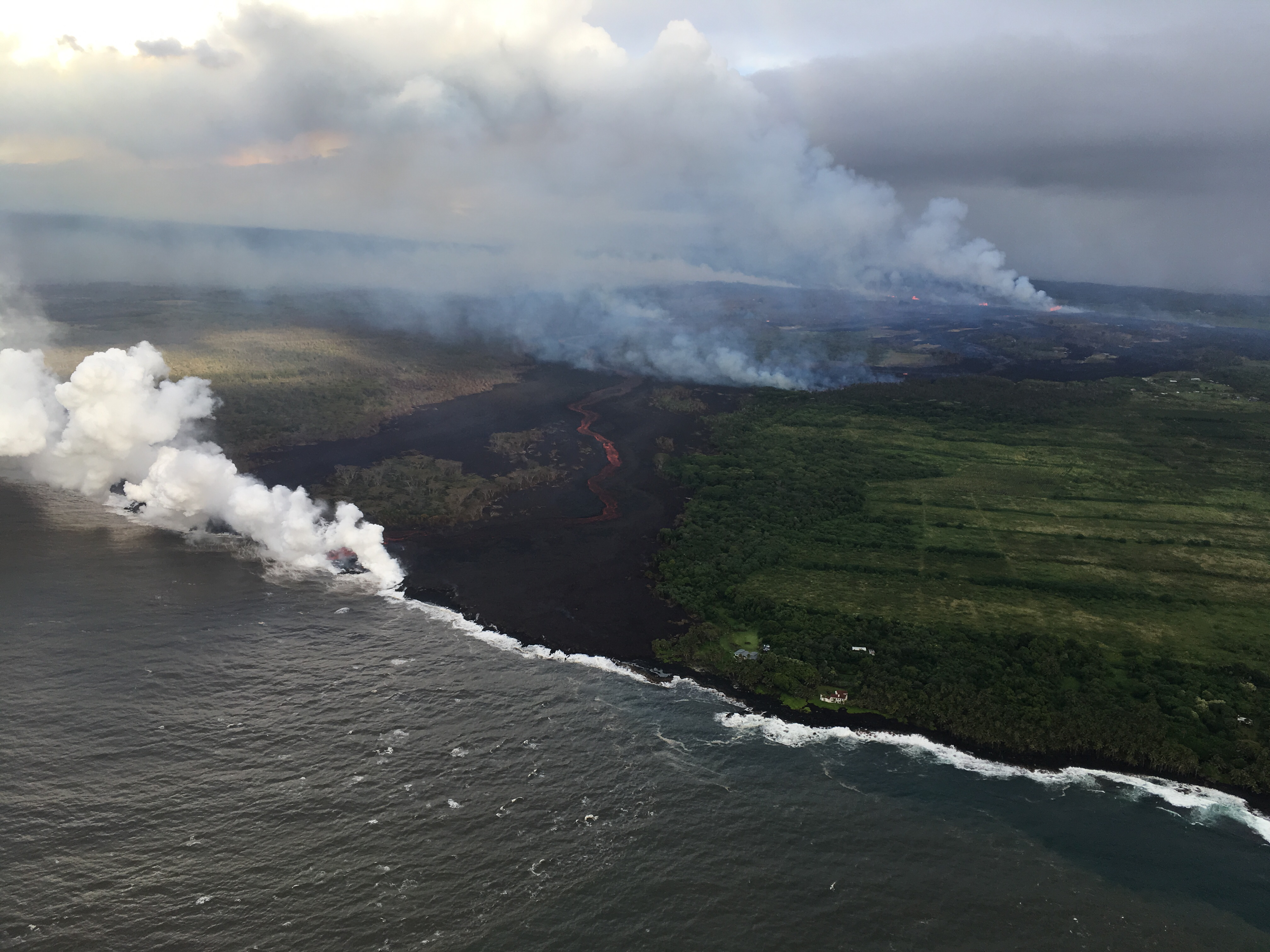
This is just a view from over the ocean looking at the ocean entry this morning. There’s only one lava channel that makes its way down to the ocean. And when the lava enters the ocean, it boils seawater. What you’re left with is hydrochloric acid plume with lots of little particles in it. It’s very corrosive, it’s kind of like the vicinity of lemon juice or weak battery acid. It’s not very good to be underneath that plume.
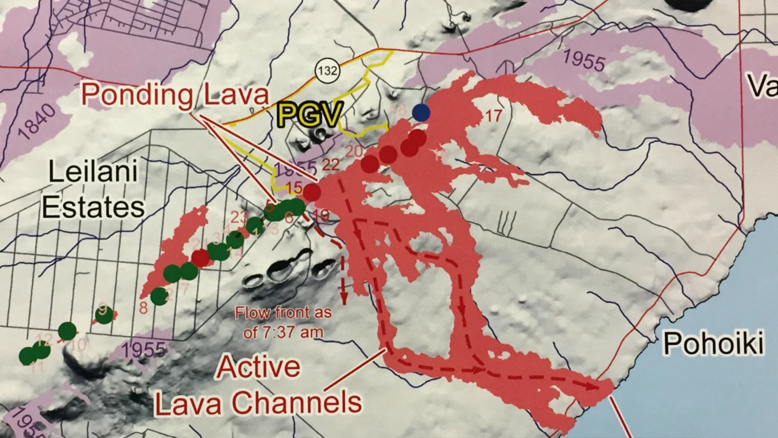
So this is a map — it’s a little hard to read, it’s a little washed out, I realize— but I wanted to point out something that you’ve heard about on the news, and we’ve tried to talk about, and that is the changing chemistry of the lava that’s being erupted from the East Rift Zone.
And this map I’ll explain just a little bit here. So here’s Kapoho Crater, Green Mountain. Here’s the lava flow path from 22. Down here you can see where it splits and comes back together, and it enters the ocean. I mentioned activity around fissure 5 and 16 that generated a small lava flow today. As of this morning it had spread to this distance. [He uses laser pointer to indicate that S-shaped, dashed red line capped with an arrow that ends near the word “as”.]
. Later in the afternoon some fissures became active again in the middle of Leilani Estates. So like I said, it’s very hard to track all of these different fissures that become active. One thing that’s clear is that more magma is coming to the surface now than earlier in the eruption sequence.
Ok, so these things I wanted to point out are these different green colors: the green colors, the red colors, and this little blue one. So each of those dots represent one of the fissures.
And the green color represents the type of lava that we think was stored in the Rift Zone for decades, before it came out and erupted at the surface. That lava presumably was forced up to the surface as magma moved down the East Rift Zone, pushed its way into the Lower East Rift Zone, and forced that magma to the surface.
Then, starting at around … Fissure 16, I think it is, the lavas here shown in the red began showing a definite mixture of lava stored in the rift zone for decades, and the lava or magma that originated in the upper part of the East Rift Zone beneath Pu’u O’o, and perhaps even the summit.
So what we’re observing now is a more voluminous activity, the more fluid lava flows, as the arrival of the hotter, less viscous, more fluid lavas that originated further up into the Rift Zone. So now we’re seeing the fresh stuff come up to the surface. And so as we suggested before when that happened we could see additional fissures form, more voluminous lava flows, and where they flow depends on where the vent’s actually located.
So far, essentially, most of the lavas have flowed away from PGV, away from Highway 132,to the south, and into the ocean.
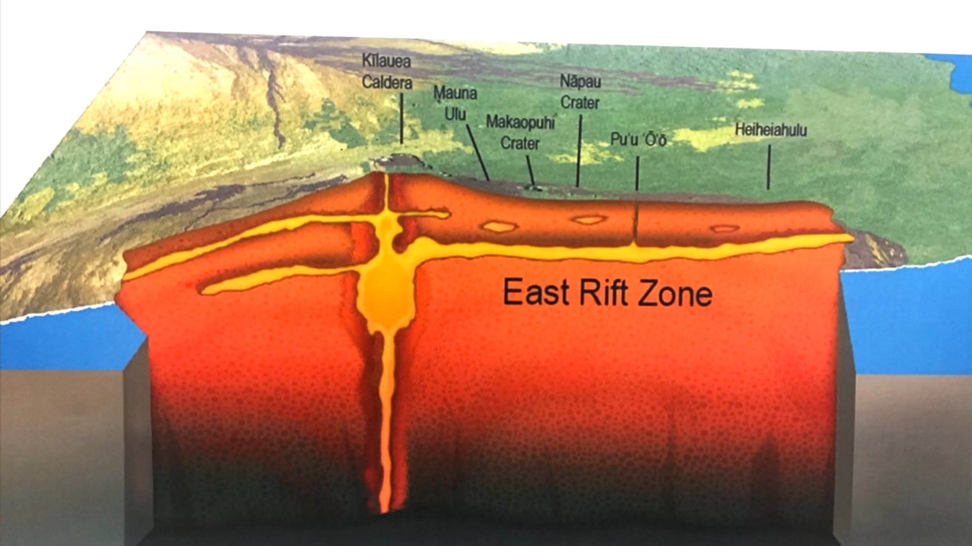
And my final slide— I showed this a week or so ago— this is a giant cutaway of the volcano, just to help visualize what I just described.
So this is the summit of the volcano, where Halema’unma’u is and is the source of the explosive eruptions that you’ve read about and heard about. And this is a cutaway right through the East Rift Zone, Here, say, the location of Pu’u O’o. And this orange [yellow] pipe is meant to locate the conduit that existed from the summit to Pu’u O’o. But then on April 30, began moving down the rift zone and brought magma down into the Lower East Rift Zone.
So initially the magma originated from here [points to area under Pu’u O’o], it continued to move down into this location here [points to green area to the right of the cutaway] And then on about May 1 the summit of the volcano began subsiding, as a reflection of magma now moving out of the summit reservoir into the rift zone and further down into the Lower East Rift Zone. So in a sense, there’s an open conduit from the summit to the Lower East Rift Zone.
And my final comment is that for the 35 years or so that Pu’u O’o was active, there was a kind of balance between the summit reservoir and the location or elevation where Pu’u O’o erupted. There was sort of a symbiotic relationship with the summit and Pu’u O’o. Well now, that vent, the new vent system is located almost at sea level. So the whole system has to adjust to some sort of new balance [makes seesaw gesture with hands] And until that balance is reached, or something else changes, we expect magma to continue moving from the summit reservoir into the rift zone and further down into the Lower East Rift Zone.
So that suggests that we’re in it for the long haul.We don’t know how long this eruption’s going to last, but for now, it looks like it’s just going to continue, and we take it day by day.