Before this, the main thing USGS was using drones for was LIDAR, but today’s Photo & Multimedia entry on HVO’s website provides drone footage for both the summit steam/ash plume and Leilani/Puna lava flows.
SUMMIT ERUPTION:
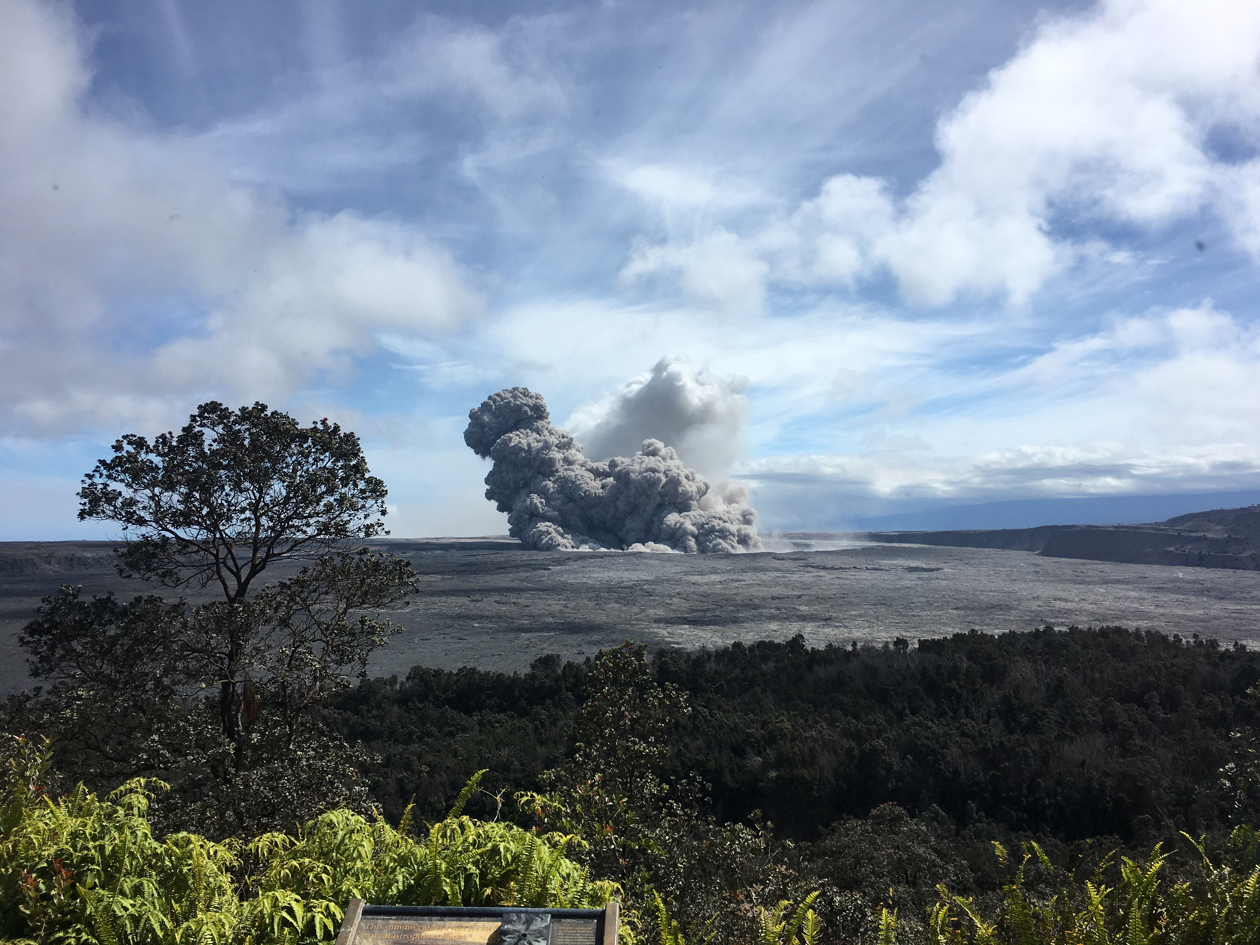
This video was filmed on May 21, 2018, with a UAV (unmanned aerial vehicle). Limited UAV flights above the hazardous Kīlauea summit area, which is currently too dangerous for geologists to enter for ground observations, are conducted with permission from the National Park Service. […] At Kīlauea Volcano’s summit, a nearly continuous plume of gas and steam billows out of the Overlook vent and drifts with the wind. Explosions are occurring about two times a day, producing ash that rises to a height of between 8,000 to 10,000 feet above sea level. Small ash emissions occur more frequently. The larger explosions produce ash that is blown downwind, and trace amounts have fallen in nearby communities.
Addendum: there was a 6PM 10,000 foot ash explosion & plume this evening (Civil Defense photo, USGS video), sending ash southwest.
PUNA LAVA ERUPTION:
This footage is from an Unmanned Aircraft System (UAS) hovering near fissure 22 during the overnight hours of May 22, 2018, and looking down on the fountaining fissure complex. The view rotates upward (to the south) to track channelized lava as it flows toward the Pacific Ocean, about 3 mi (5 km) away. The ocean entry is in the distance, recognizable by a small plume. The USGS National Unmanned Aircraft Systems Project Office is assisting with remote data collection and mapping of lava flows and hazards…
HVO’s Photo & Multimedia blog also posted impressive Hilo Civil Air Patrol aerial photos of the lava rivers from yesterday, as well as an image of Fissure 22 taking a nap (it’s still going but lower today on Civil Beat’s Livestream) while the fissures west of it (and uprift) that activated yesterday inundated Leilani Estates.
As an aside: people keep posting ridiculous rumors, so the USGS had to reassure everybody that Mauna Loa is NOT erupting.
Latest video this evening from HNN reporter Mileka Lincoln:
#LeilaniEstatesEruption #KilaueaVolcano LATEST: Darkness falls on #LeilaniEstates this evening & the sky lights up with the intensity of 3 fountaining fissures where the road ends at Leilani Ave & Luana St https://t.co/9MZRnVNAGF @HawaiiNewsNow #HINews (Video: Leomana Turalde) pic.twitter.com/uooI4BUb9E
— Mileka Lincoln (@MilekaLincoln) May 25, 2018
Earlier in the day… welcome to the Leilani Estates Lava lake. (warning: noisy)
The residents are being absolute champs in coping with this. Here’s another video clip of the lava lake with the homeowner whose home is just outside of it. They’re very philosophical, realizing they took a gamble, which is more mature than some of the people criticizing them for taking a chance on a place that hasn’t had an eruption in about 60 years. And they’re helping one another.
…
Oh, my mistake. It’s a lava pond.
Kilauea message: Fissure 22 lava output has increased a bit over the past several hours and its lava channel to the ocean entry is consequently a little more incandescent. Low-level spatter at fissures 15 and 16. Fissure 13 has a low fountain through its lava pond.
— USGS Volcanoes🌋 (@USGSVolcanoes) May 25, 2018
Mick Kalber’s helicopter overflight video today does a great job of showing the “pond,” the fissures headed from there past the geothermal plant, and the lava rivers flowing south from those fissures towards the ocea.
USGS Updates, News Roundup, And More Vivid Videos:
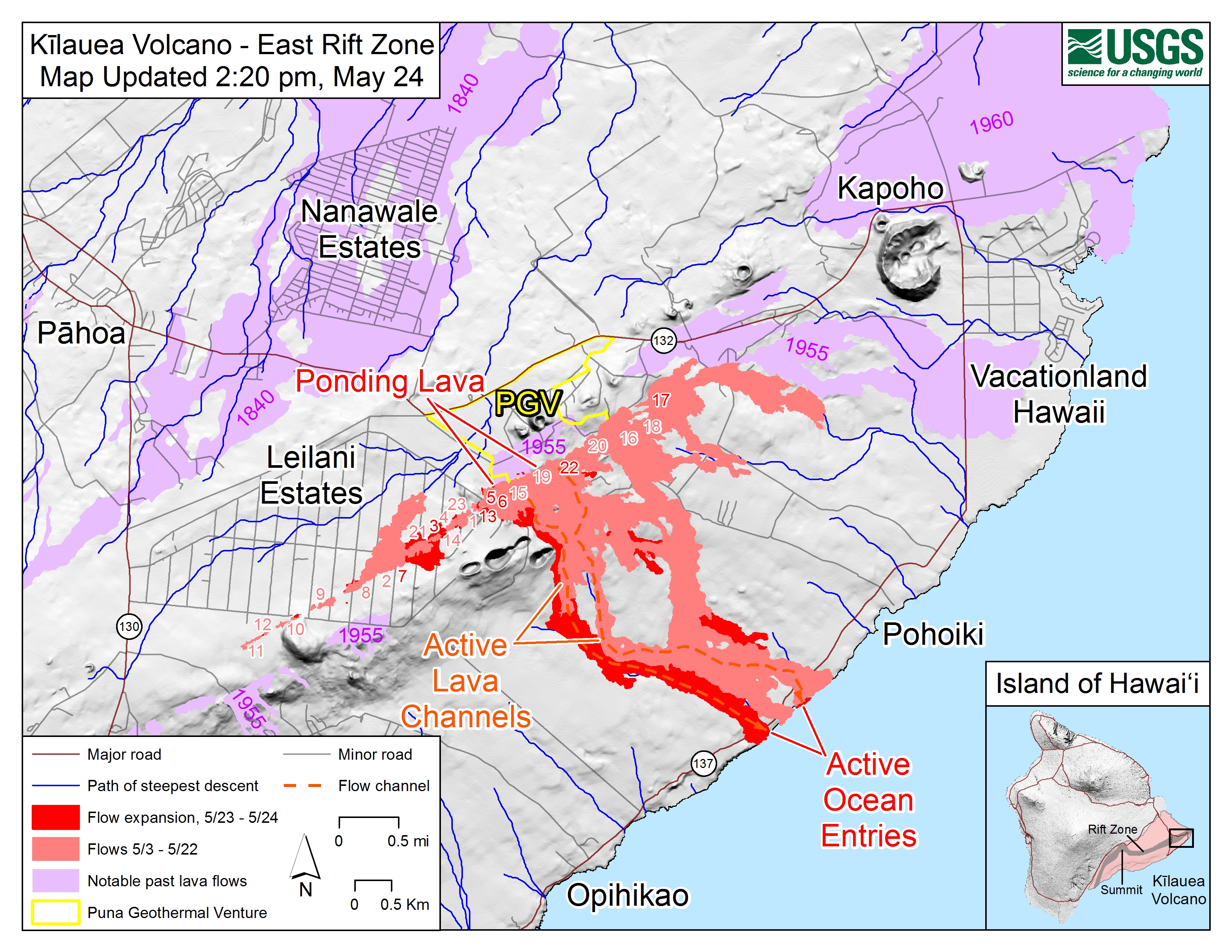
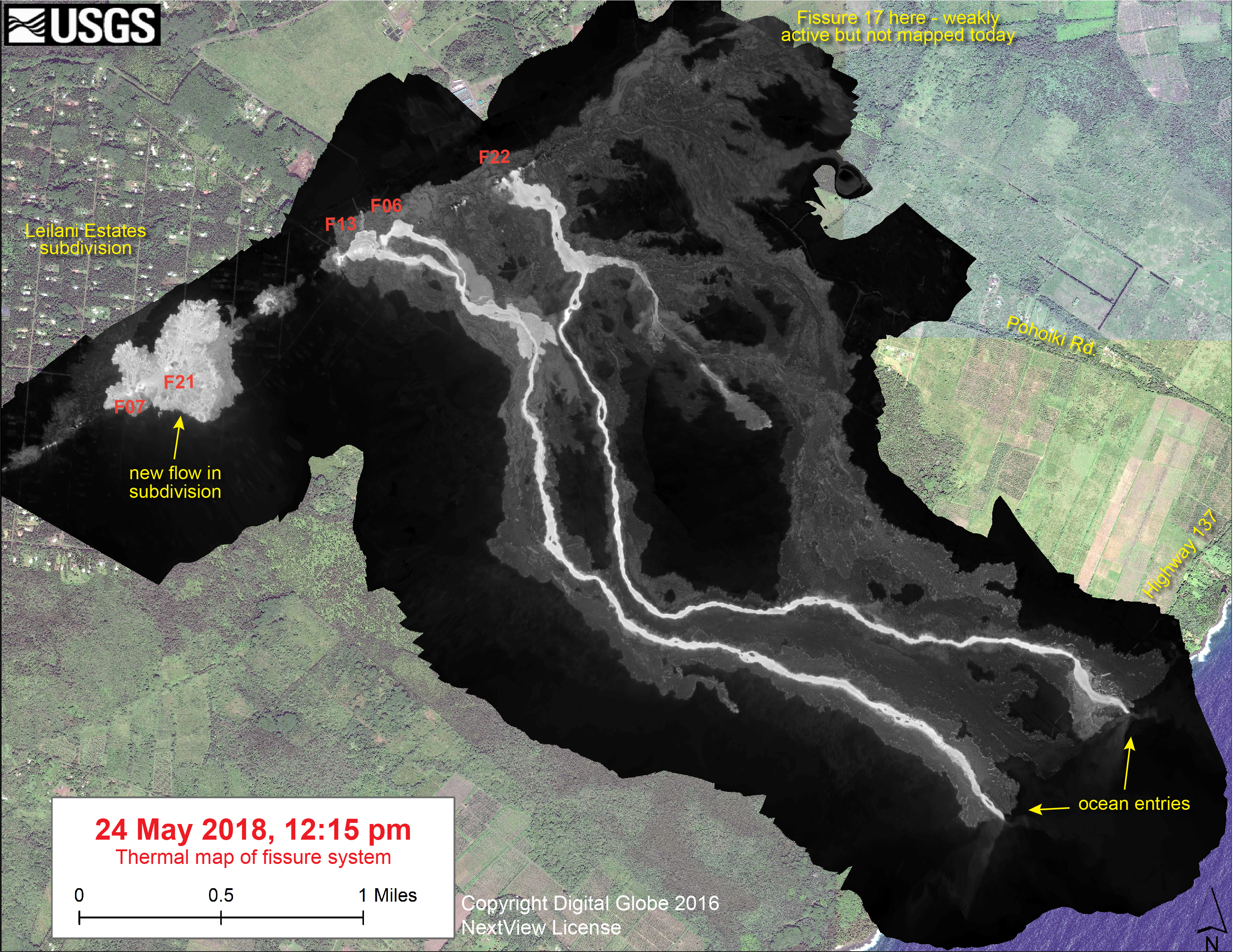
May 24 #HVO #Kilauea video update (Wendy Stovall): Fountaining & lava flows b/t fissures 8 & 22 (2 mi dist). 2 lava channels flowing to coast, easternmost split to make 3rd ocean entry. Small explosive eruptions & shallow M3.9 EQ @ summit. https://t.co/tAW6CXpRze#KilaueaErupts
— USGS Volcanoes🌋 (@USGSVolcanoes) May 24, 2018
USGS Wendy Stovall: Good morning everyone we have the update for Kīlauea Volcano today. There’s still activity at the summit and in the lower east rift zone. The extent of fountaining and lava flows is about two miles and that’s going from fissure eight all the way up to fissure twenty two.
There’s two main channels of lava that are issuing from those vents going down to the coast and one of the channels the furthest channel to the east is bifurcating, so it’s splitting into two, and now we have three ocean entries at the coast. Fissure seven is producing the most volume of lava right now, it kind of opened up very recently and there are lava flows that are going to the east from that vent and they’re reaching about 1,300 feet away from the source and the eastern most extent right now is at Kaupili and Leilani streets in Leilani Estates.
Up at the summit there’s been some more small explosive eruptions the largest one occurred yesterday at 6:44 pm and that produced an ash plume that went up to about 7,000 feet. You’re still going to experience ash downwind if you’re in that summit area and there was a 3.9 magnitude earthquake right at the summit just below the Hawaiian Volcano Observatory building that preceded that explosion. That’s the update of today. Thanks.
New FAQ on #Kilauea summit activity: Ashfall hazards, what we might see as far as explosive eruptions, and what's happened in the past: https://t.co/J5aUa8fvJb. See https://t.co/8lsCP4dHhm & https://t.co/rENzxxMfzO for the history of explosive summit activity #KilaueaErupts
— USGS Volcanoes🌋 (@USGSVolcanoes) May 24, 2018
Video captures rising plume from explosion at Kīlauea Volcano’s summit ~6:00 PM HST, May 24, 2018. https://t.co/nnql3zwdGA pic.twitter.com/tVeCuXx29b
— USGS Volcanoes🌋 (@USGSVolcanoes) May 25, 2018
Audio from USGS (May 24) Conference Call:
Paraphrase/excerpts: USGS Wendy Stovall: Eruption activity in Leilani Estates continuing to migrate west back along the fissure line. ~2 mile long line of activity: low fountaining, feeding massive channelized lava flows going down to coast. 2 primary channels at the moment. Easternmost has split in 2, making 3 ocean entries total. Some lava moving north from the fissures but mostly south. Summit: cloudy/foggy so hard to see much,but Mauna Kea cams have shown a plume rising 6000 feet asl, Meteorologist update (probably NWS): stronger ne winds today may blow ash farther. Note: ash plume has to rise about 15,000 feet to reach westerlies which could blow it over other parts of island.
More science-y stuff
Erik Klemetti’s Rocky Planet Blog: Kīlauea’s Fissures Pour Out Lava While Merapi Continues to Cause Concern
Crisis Communication of Volcanic Proportions – podcast interviewing Dr. Janine Krippner, who’s been trying to shoot down wild rumors and inform public on social media
Local News Reports Roundup
HawaiiNewsNow:
[May 24] At least six separate fissures are erupting in lower Puna, pumping out an incredible 40 to 60 cubic feet of lava per second, spewing fountains of lava into the air and creating flows that are cascading into the sea some three miles downslope.
Since the first outbreak opened three weeks ago, lava has claimed at least 50 structures and covered more than 1,700 acres in lower Puna, though authorities say those figures are conservative. Ash plumes have also been a common sight from Kilauea’s summit/
- How to help: volunteering and charity groups actively helping evacuees; where to donate. (warning: autoplay video above article, true of most HNN)
- Coast Guard is enforcing a 300m exclusion zone around the lava ocean entry points.
- It may be only the second time scientists have been able to study those blue methane flames (good HNN video report, I think from yesterday. Also has good footage of Leilani Estates, cracks, and interviews with residents.)
- Besides Fissure 17 and others reactivating and putting a lava lake on the northeast side Leilani Estates, Nohea Street’s 3-foot cracks have widened to 10 or more today. Cracks that haven’t yet erupted are widening. USGS Steve Brantley says “The rift zone is being forced apart,” showing more activity on the way. (HNN News)
#LeilaniEstatesEruption #KilaueaVolcano LATEST: 3 weeks after the first fissure broke out on Mohala St in #LeilaniEstates, USGS HVO officials say there is no indication that this eruption will be coming to an end as activity picks up https://t.co/Ut0G4PxBCC @HawaiiNewsNow #HINews pic.twitter.com/gkE6riniks
— Mileka Lincoln (@MilekaLincoln) May 25, 2018
BigIslandNews:
- “Lava Fissures Reactivated Overnight” – BigIslandNews rundown of today’s events notes at 8AM 3 lava flows were entering ocean “between Pohoiki Bay and MacKenzie State Park”, although I think two of them merged later in the day. Also: “Fissure 7 reactivated this morning and is actively fountaining lava. The flow is moving towards the east into Leilani Estates. It has covered Kaupili and Mohala Streets, between Leilani Avenue and the fissure line.” I’m guessing that’s the “lava lake”.
Last night’s lava eruptions and another glimpse of the “lava lake”:
Star-Advertiser:
- Hawaii Civil Defense has laid out a plan for a 4-hour air evacuation of approximately 1,000 residents who haven’t yet left some Puna communities that will be cut off if Highway 130 is cut. (I would just tell them time to leave; those pahoehoe rivers move far too fast if they pile up behind a berm of lava and it gives way.)
- Photo/Video Gallery of Leilani Estates with new 20-foot bed of lava coming up, interview of resident.
- Constantly-updated eruption page has good photo of 6PM ash plume at summit.
- Partial reopening of some parts of Hawaii Volcanoes National Park far from the summit explosions.
PHOTO GALLERY FROM CIVIL DEFENSE:
Interested in viewing photos and videos of the #KilaueaEruption? Check out out our Flickr page updated regularly with footage of the East Rift Zone eruptions, courtesy of the Hawaii County Fire Department. Visit https://t.co/Q0zszfWZJo pic.twitter.com/GYIXD6w2lT
— COH Civil Defense (@CivilDefenseHI) May 24, 2018
MISCELLANEOUS
- What It’s Like Spending Three Days Watching a Volcano – May 16 interview and video with Anthony Quintano, the photographer behind the lava livestream. Also a spiffy 360 degree moving video (?) of him working out in the field next to some lava.
- Among the details of 6AM Civil Defense report, “work continues to seal the wells” [of PGV plant]. I’d seen one report that they were already “plugged,” but Tuesday they were just finishing up quenching the wells, so I suspect someone mixed up one with the other.
- National Guard escorted a media pool into Leilani Estates today so they can experience eruption firsthand. Sounds like they were pretty gobsmacked by what they saw. (BigIslandNow article with photos.)
Lower Leilani Estates tonight – a mass of churning lava & exploding spatter, it resembles a fiery river estuary. Individual fissures hard to distinguish amongst the maelstrom. Resembles a scene from another planet, never seen anything like this before #Kilauea #Hawaii #volcano pic.twitter.com/npAs7DOF0O
— James Reynolds (@EarthUncutTV) May 25, 2018
Isaac Krakaur on Facebook live posted this around 9PM, showing Kaupili Street being overrun:
Posted by Isaac Krakauer on Thursday, May 24, 2018
More of Mileka lincoln & Crew’s LAVA footage:
#LeilaniEstatesEruption #KilaueaVolcano MAHALO: Just taking a moment to mahalo all those who have graciously hosted us, escorted us, and watched over us as we have worked to cover history unfolding here on Hawaiʻi Island 👉🏽 https://t.co/vAVWCzDPLi @HawaiiNewsNow #HINews pic.twitter.com/bzok1sKdNh
— Mileka Lincoln (@MilekaLincoln) May 24, 2018
#LeilaniEstatesEruption #KilaueaVolcano LATEST: Unbelievable new video of the incredibly dynamic lava fountains and lava lake inside #LeilaniEstates; Fountains erupted from Fissures 5, 6, 13, and 19 & are feeding a flow to the south https://t.co/LAsP8e1C3b @HawaiiNewsNow #HINews pic.twitter.com/O9iBOJ758c
— Mileka Lincoln (@MilekaLincoln) May 24, 2018
#LeilaniEstatesEruption #KilaueaVolcano LATEST:My photographer @CaseyLundHNN captured incredible closeups of pāhoehoe lava fountains shooting into the air & the cone slowly building as powerful ʻaʻa lava kicks up & stacks upon itself https://t.co/Hdmbz5VGLE @HawaiiNewsNow #HINews pic.twitter.com/IkGxQAkofj
— Mileka Lincoln (@MilekaLincoln) May 24, 2018
#LeilaniEstatesEruption #KilaueaVolcano LATEST: New video provides an upclose look inside #LeilaniEstates where several fissures are fountaining; USGS confirms this is the most active area of the Kīlauea’s lower East Rift Zone https://t.co/41FPKK7HtU @HawaiiNewsNow #HINews pic.twitter.com/yhplY96uzo
— Mileka Lincoln (@MilekaLincoln) May 23, 2018
#LeilaniEstatesEruption #KilaueaVolcano #HappeningNow: Residents capture what’s left after intensified activity in #LeilaniEstates as USGS clarifies eruption isn’t a new fissure but coming from fissures 17 & 7 going east https://t.co/1Lcfm9euZz @HawaiiNewsNow (Video: Brad Lewis) pic.twitter.com/XB3na1CGC9
— Mileka Lincoln (@MilekaLincoln) May 24, 2018
#LeilaniEstatesEruption #KilaueaVolcano UPDATE: An incredible volume of lava — an estimated 40-60 cubic feet per second — is spewing from active fissures in #LeilaniEstates; USGS confirms activity is “migrating west” across 2 miles https://t.co/SY10CZ3RjE @HawaiiNewsNow #HINews pic.twitter.com/h3BuINwUTC
— Mileka Lincoln (@MilekaLincoln) May 24, 2018
#LeilaniEstatesEruption #KilaueaVolcano LATEST: Residents assess extensive damage across #LeilaniEstates after increase in fissure activity overnight. Even houses that were spared may never be inhabitable again https://t.co/pOt9dZI9pg @HawaiiNewsNow #HINews (Video: Brad Lewis) pic.twitter.com/KLhzSDF3pC
— Mileka Lincoln (@MilekaLincoln) May 25, 2018
#LeilaniEstatesEruption #KilaueaVolcano UPDATE: Puna Geothermal Venture reports their wells remain stable & lava hasn’t encroached onto the plant site; ongoing monitoring for hydrogen sulfide taking place & none detected at this time https://t.co/796xRRIjEn @HawaiiNewsNow #HINews pic.twitter.com/PdWzpuhbeE
— Mileka Lincoln (@MilekaLincoln) May 25, 2018
#LeilaniEstatesEruption #KilaueaVolcano LATEST: On our way into #LeilaniEstates, we were jolted by this fountaining lava activity at the end of Leilani Avenue and Luana Street; experts warn fissures can reignite without warning https://t.co/X0YAO7ndEh @HawaiiNewsNow #HINews pic.twitter.com/KBa0q4fm4Z
— Mileka Lincoln (@MilekaLincoln) May 25, 2018