May 24: USGS Acquires Drones, Leilani Estates Acquires Lava Lake

Before this, the main thing USGS was using drones for was LIDAR, but today’s Photo & Multimedia entry on HVO’s website provides drone footage for both the summit steam/ash plume and Leilani/Puna lava flows.

SUMMIT ERUPTION:

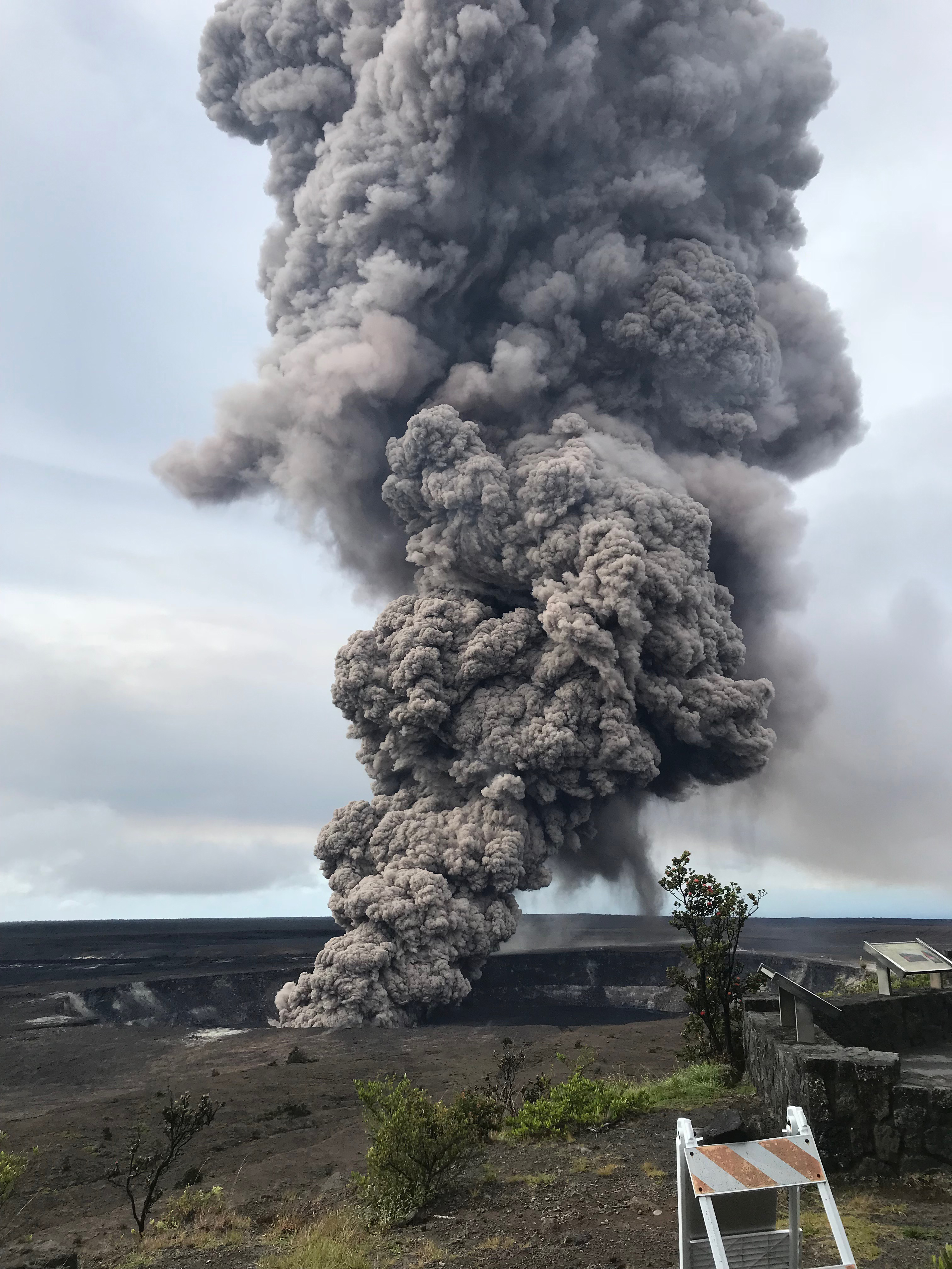
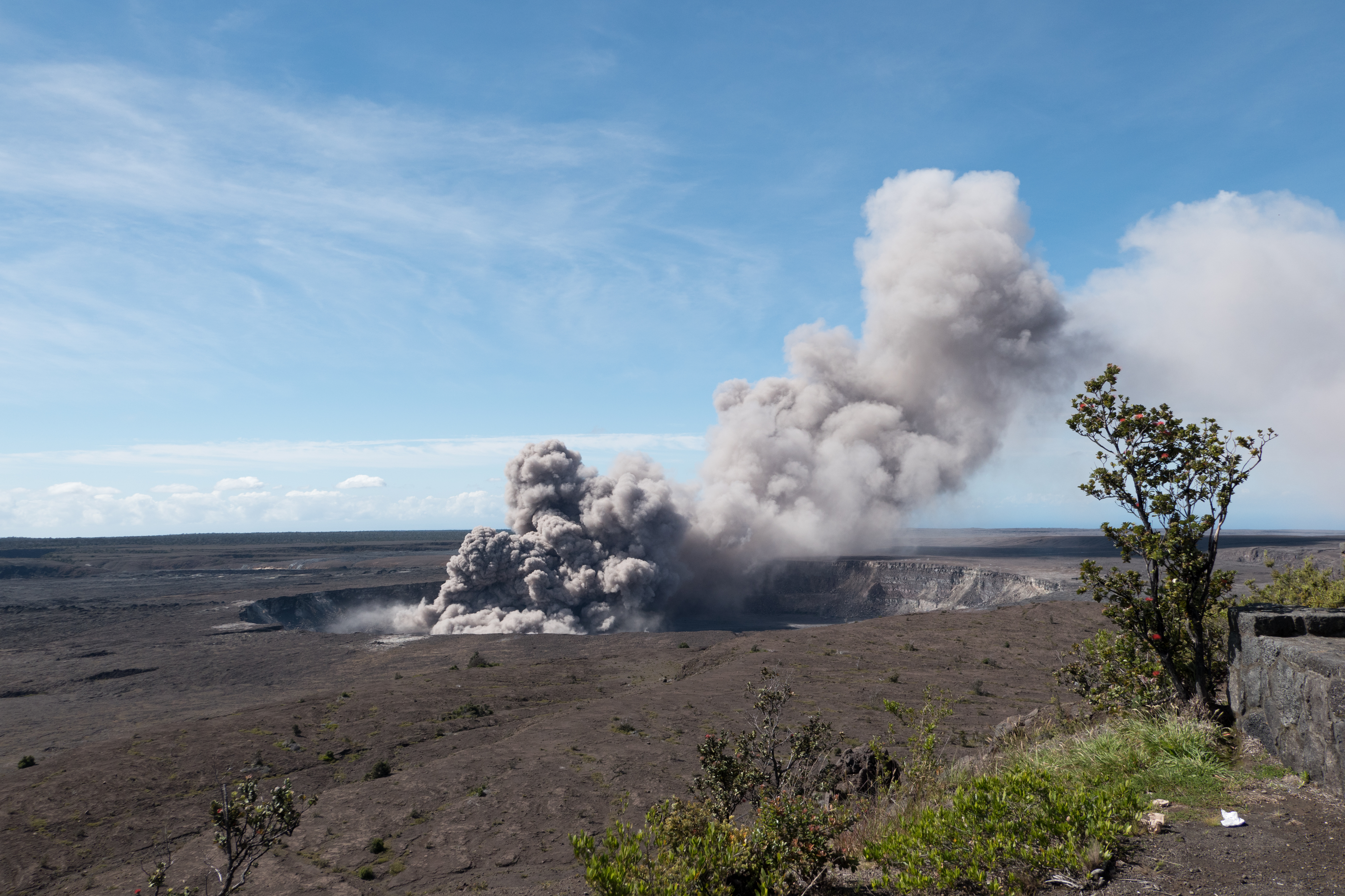
This video was filmed on May 21, 2018, with a UAV (unmanned aerial vehicle). Limited UAV flights above the hazardous Kīlauea summit area, which is currently too dangerous for geologists to enter for ground observations, are conducted with permission from the National Park Service. […] At Kīlauea Volcano’s summit, a nearly continuous plume of gas and steam billows out of the Overlook vent and drifts with the wind. Explosions are occurring about two times a day, producing ash that rises to a height of between 8,000 to 10,000 feet above sea level. Small ash emissions occur more frequently. The larger explosions produce ash that is blown downwind, and trace amounts have fallen in nearby communities.

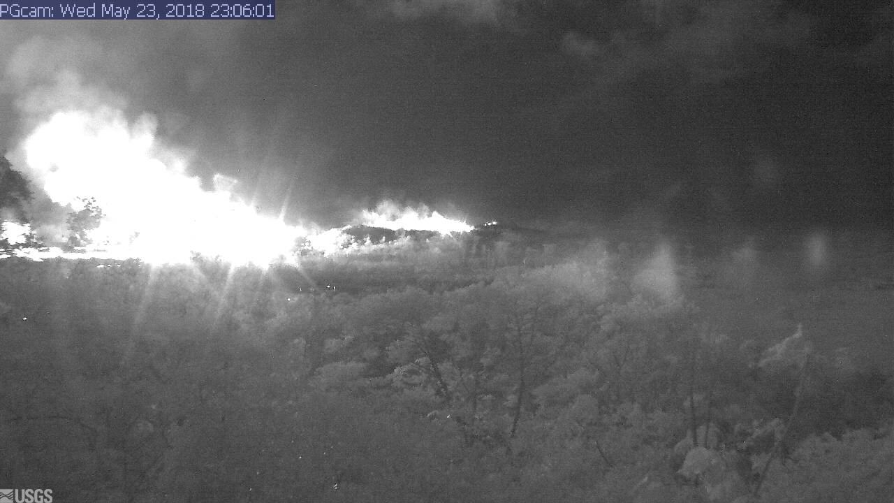
Addendum: there was a 6PM 10,000 foot ash explosion & plume this evening (Civil Defense photo, USGS video), sending ash southwest.

PUNA LAVA ERUPTION:

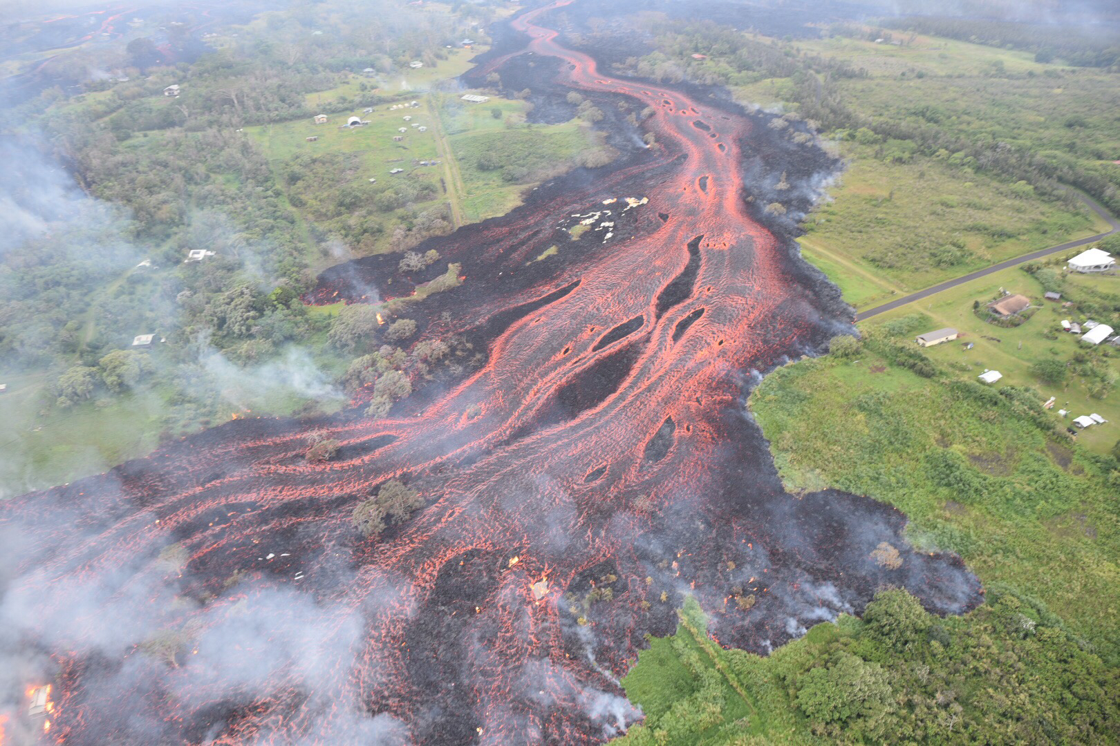
This footage is from an Unmanned Aircraft System (UAS) hovering near fissure 22 during the overnight hours of May 22, 2018, and looking down on the fountaining fissure complex. The view rotates upward (to the south) to track channelized lava as it flows toward the Pacific Ocean, about 3 mi (5 km) away. The ocean entry is in the distance, recognizable by a small plume. The USGS National Unmanned Aircraft Systems Project Office is assisting with remote data collection and mapping of lava flows and hazards…

HVO’s Photo & Multimedia blog also posted impressive Hilo Civil Air Patrol aerial photos of the lava rivers from yesterday, as well as an image of Fissure 22 taking a nap (it’s still going but lower today on Civil Beat’s Livestream) while the fissures west of it (and uprift) that activated yesterday inundated Leilani Estates.

As an aside: people keep posting ridiculous rumors, so the USGS had to reassure everybody that Mauna Loa is NOT erupting.

Latest video this evening from HNN reporter Mileka Lincoln:

Earlier in the day… welcome to the Leilani Estates Lava lake. (warning: noisy)

The residents are being absolute champs in coping with this. Here’s another video clip of the lava lake with the homeowner whose home is just outside of it. They’re very philosophical, realizing they took a gamble, which is more mature than some of the people criticizing them for taking a chance on a place that hasn’t had an eruption in about 60 years. And they’re helping one another.

Oh, my mistake. It’s a lava pond.

Mick Kalber’s helicopter overflight video today does a great job of showing the “pond,” the fissures headed from there past the geothermal plant, and the lava rivers flowing south from those fissures towards the ocea.

USGS Updates, News Roundup, And More Vivid Videos:

Continue reading May 24: USGS Acquires Drones, Leilani Estates Acquires Lava Lake

May 23: Blue Flames? Now You’re Just Showing Off

Kilauea’s chief resident has found another way to amaze and/or injure people reckless enough to get too close to her redecorating:

I had a hunch the Lower East Rift Zone webcam would be interesting tonight. I wasn’t disappointed:

I see what they mean about the Leilani fissures further west (uprift, towards the camera) reactivating today.

Edited to add: Yikes.

It’s 11:06 PM in Hawaii; second screengrab an hour or so later.

I was about to hit post, when I saw erstwhile reporter Mileka Lincoln and her crew posted this. Wow.

(recorded just an hour ago at time of this post.)

Now, let’s have the evening roundup of poignant news, amazing views, and interesting science…

Continue reading May 23: Blue Flames? Now You’re Just Showing Off

May 21: Daily Roundup, Fire & Water Edition

Mick Kalber’s daily helicopter flyover includes some intense views of the rivers of lava heading into the ocean, and the big complex of fountains— 20? 22? we’re starting to lose track— that have dominated the Lava Livestream With Rooster for the last several days.

May 21 Fissure Map (USGS Maps page)

The USGS thermal scan is very informative, too: an infrared satellite detects heat sources (the whiter the image, the hotter it is), and USGS then overlays it on a daylight satellite image of same area. Result, accurate map of where the main flows are, even when they crust over so the lava inside is hidden:

May 21 Heat map of today’s flows (USGS Maps page)

Below the cut: a digest of the day’s eruption news, USGS updates (summarized), and striking social media images and video clips like this:

Continue reading May 21: Daily Roundup, Fire & Water Edition

May 18/19: Good Summary of Eruption to Date

USGS aerial view of lava flow, May 19. (full-sized)

Volcanologist Erik Klemetti pulls everything together for us, reviewing how the Leilani Fissure lava eruptions and the summit ash/steam eruptions have progressed.

Link:

Kilauea Eruption Continues: How Long Could It Last?

The eruption at Kīlauea is still captivating the nation, as it should because this volcano hasn’t behaving like this in almost a century. I thought I’d take a moment to step back and review of the main events so far and what it might all mean for Kīlauea and the people who live around the volcano. These eruptions are separated by a long way if you look at the satellite data and should almost be treated at two different events..


Also, here’s today’s CivilDefense briefing and BigIslandVideonews’ splice of afternoon USGS briefing with geologist Carolyn Parcheta plus recent video footage.

Taking from video  (basically telling us which fissures are doing what):

Continue reading May 18/19: Good Summary of Eruption to Date

May 17, Early Morning: Steam Explosion!

May 17, 4:17 AM, the first honest-to-gosh steam explosion like they’ve been predicting (instead of just a rock and lava explosion) sent an ash cloud up 30,000 feet. Gemini Observatory caught it on timelapse:

According to volcanologist Erik Klemetti, the blast threw some 1000-pound blocks, the only place I’ve seen this. See blog post (more pics).

By morning, things had settled down:

Continue reading May 17, Early Morning: Steam Explosion!

May 9-10: USGS Warns of Possible Steam Explosions

Attention shifted back to the summit on May 9, when a 3.1 earthquake set off a rockfall that agitated the lava lake and sent up a 6000-foot poof of ash (video clip National Parks site):

Rockfall into Halema’uma’u lava lake sends up plume of ash, 8:27 May 9.

Rockfalls caused poofs of ash like this even back when the lava lake was full, but that was more than usual. (See also USGS video from May 7, when lava lake was still visible, showing how falling rocks agitate it).

However, that was just a teaser. The big news was the dropping lava lake…

…prompted HVO to issue its first warning about steam explosions if the lava dropped below the water table.

Hawaii Volcanoes National Park closed Friday May 11 as a precaution, since the lava lake was projected to reach the water table sometime that day. For the next few days it continued to send up a white plume of steam and/or ash clouds when rocks from the sides of the chimney fell in:

[USGS] May 11, 9:12 AM: second ash explosion
On steam (phreatic) explosions:

Continue reading May 9-10: USGS Warns of Possible Steam Explosions