Changes to Halema’uma’u Crater, Kilauea Summit

Before and after: Halema’uma’u in 1992 & 2018

Left:  November 1992, photo by Winston Brundige*
Right: Screengrab of HVO webcam on June 19, 2018


*used with permission. Thanks, Dad.

Before and after: May vs June 2018

Left: USGS photo from Volcano House, May 19, 2018
Right: USGS photo from Volcano House, June 13, 2018

  • Halemaʻumaʻu before this started: 1 km (0.6 mi) across, 85 m (~280 ft) deep.
  • Halema’uma’u Jun 15, 2018: 1 X 1.3 km (0.6 to 0.8 mi) dimensions, 370 m (1,210 ft) deep.
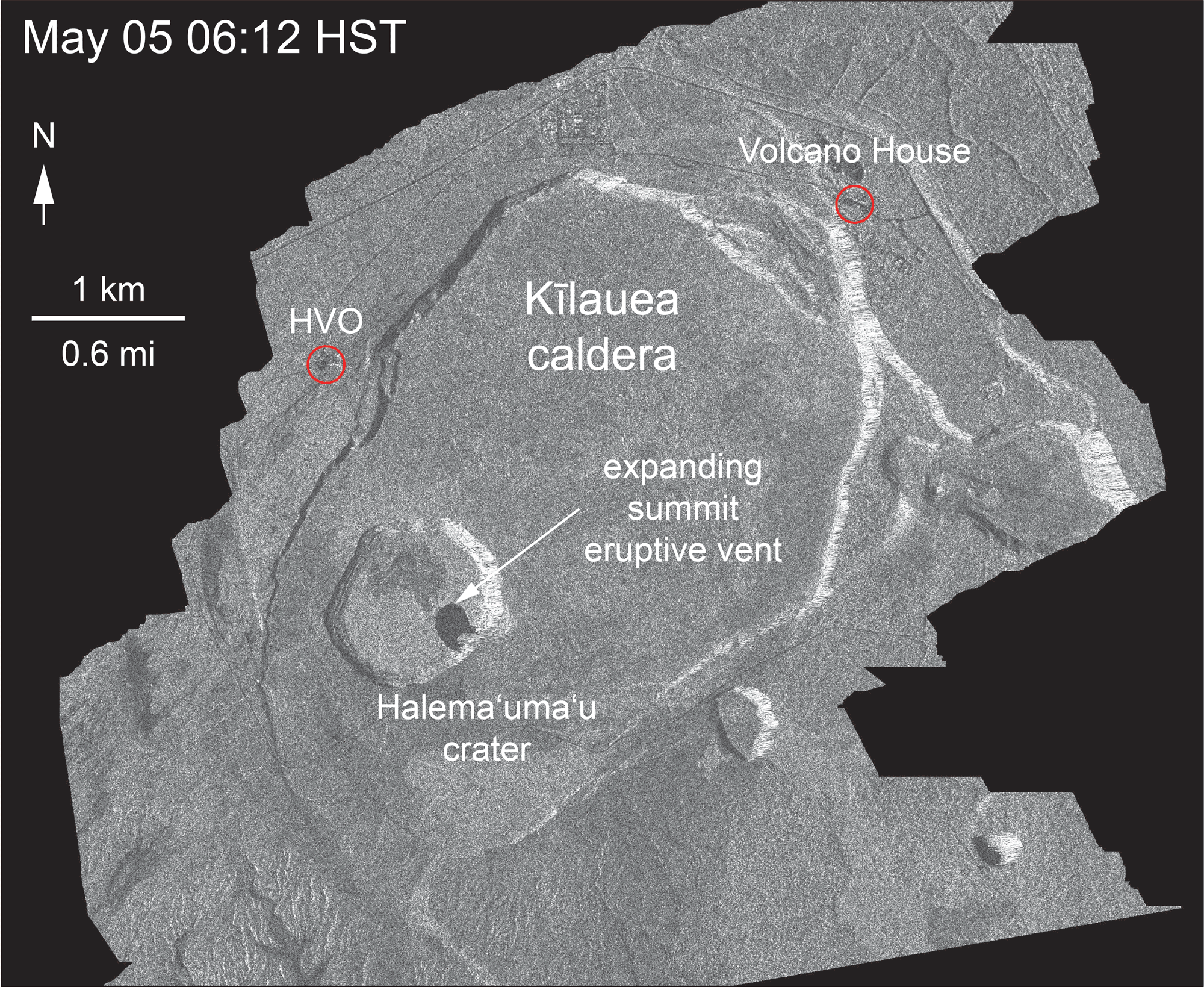
Radar Images, May 5-June 18

Thanks to the Italian Space Agency for taking a radar satellite image of Kilauea about once a week:

USGS: “May 5 and June 18 at about 6:00 a.m.[…]The last five images in the sequence, from May 29-June 18, show the development of several cracks outside Halema‘uma‘u (also seen in recent UAS footage of the crater) and inward slumping of a large portion of the western, southwestern, and northern crater rim. Much of this motion appears to be coincident with the small explosions from the summit that have taken place on a near daily basis over the past 3 weeks.” (Full-sized)
Yes, HVO and the Jaggar Museum have evacuated, and artwork has been moved to safety.

28 Days At kilauea Summit, May-June 2018
Halema’uma’u Crater, May 24-June 22. Animation of screencaps from USGS/HVO Kilauea Summit wide-angle webcam. (Full-sized)
Views of Halema’uma’u Over the Years

Continue reading Changes to Halema’uma’u Crater, Kilauea Summit

May 24: USGS Acquires Drones, Leilani Estates Acquires Lava Lake

Before this, the main thing USGS was using drones for was LIDAR, but today’s Photo & Multimedia entry on HVO’s website provides drone footage for both the summit steam/ash plume and Leilani/Puna lava flows.

SUMMIT ERUPTION:

This video was filmed on May 21, 2018, with a UAV (unmanned aerial vehicle). Limited UAV flights above the hazardous Kīlauea summit area, which is currently too dangerous for geologists to enter for ground observations, are conducted with permission from the National Park Service. […] At Kīlauea Volcano’s summit, a nearly continuous plume of gas and steam billows out of the Overlook vent and drifts with the wind. Explosions are occurring about two times a day, producing ash that rises to a height of between 8,000 to 10,000 feet above sea level. Small ash emissions occur more frequently. The larger explosions produce ash that is blown downwind, and trace amounts have fallen in nearby communities.

Addendum: there was a 6PM 10,000 foot ash explosion & plume this evening (Civil Defense photo, USGS video), sending ash southwest.

PUNA LAVA ERUPTION:

This footage is from an Unmanned Aircraft System (UAS) hovering near fissure 22 during the overnight hours of May 22, 2018, and looking down on the fountaining fissure complex. The view rotates upward (to the south) to track channelized lava as it flows toward the Pacific Ocean, about 3 mi (5 km) away. The ocean entry is in the distance, recognizable by a small plume. The USGS National Unmanned Aircraft Systems Project Office is assisting with remote data collection and mapping of lava flows and hazards…

HVO’s Photo & Multimedia blog also posted impressive Hilo Civil Air Patrol aerial photos of the lava rivers from yesterday, as well as an image of Fissure 22 taking a nap (it’s still going but lower today on Civil Beat’s Livestream) while the fissures west of it (and uprift) that activated yesterday inundated Leilani Estates.

As an aside: people keep posting ridiculous rumors, so the USGS had to reassure everybody that Mauna Loa is NOT erupting.

Latest video this evening from HNN reporter Mileka Lincoln:

Earlier in the day… welcome to the Leilani Estates Lava lake. (warning: noisy)

The residents are being absolute champs in coping with this. Here’s another video clip of the lava lake with the homeowner whose home is just outside of it. They’re very philosophical, realizing they took a gamble, which is more mature than some of the people criticizing them for taking a chance on a place that hasn’t had an eruption in about 60 years. And they’re helping one another.

Oh, my mistake. It’s a lava pond.

Mick Kalber’s helicopter overflight video today does a great job of showing the “pond,” the fissures headed from there past the geothermal plant, and the lava rivers flowing south from those fissures towards the ocea.

USGS Updates, News Roundup, And More Vivid Videos:

Continue reading May 24: USGS Acquires Drones, Leilani Estates Acquires Lava Lake

May 3: First Fissure Eruption Begins

After 2 days of earthquakes and cracks indicating magma was moving down the Lower East Rift Zone, the first fissure opened in Leilani Estates at about 5PM HST, Thursday, May 3, 2018.

Big Island News posted a 10PM video update with video footage accompanying a May 3 civil defense advisory:

Leilani Estates is about 11 miles downrift from Pu’u O’o, in the Puna District.

Maps, Videos (including drone video), INFO…

Continue reading May 3: First Fissure Eruption Begins