May 22: Reactivated Fissures Near Geothermal Plant

News media have finally gotten wind of Civil Beat’s livestream. Some have gotten the homeowner’s permission to film broadcasts on the same porch, so you may hear them if you tune in. At other times, the homeowners or friends they’ve let use the house stop by. It’s surreal yet oddly comforting to hear the homey noises of people, a pet parkeet (?), and wild chickens outside while towering, terrifying yet magnificent lava fountains boom and chuff.

As for the big picture, we’re starting to settle into a routine with Kilauea’s ongoing double eruption:

(1) Lava in Lower East Rift Zone

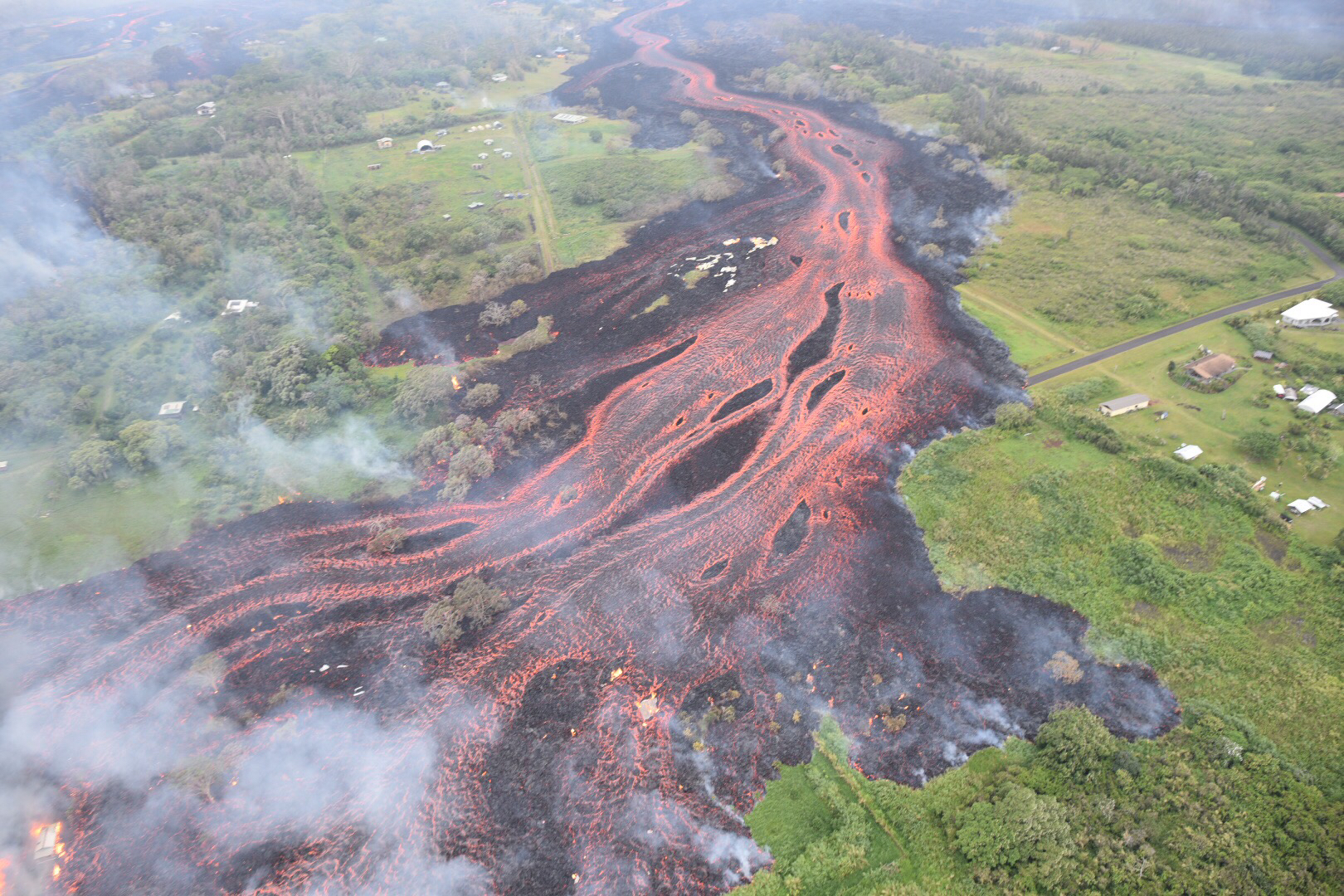
  • Lava fountains/flows in the Lower East Rift Zone continue vigorously, claiming more land and displacing more residents in Lower Puna.
  • Some fissures stop, but others reactivate. See HVO maps for what’s active.
  • Coast guard, police are trying to keep spectators away from lava entry into ocean; toxic “laze” plume from lava/seawater interaction is dangerous.
  • Puna residents are concerned about lava now encroaching on Puna Geothermal Venture site, because PVG’s lack of transparency and tardiness in capping wells has not been reassuring. (see HNN reporter Mileka Lincoln’s brief, damming synopsis). Lava-breached wells might emit toxic hydrogen sulfide.
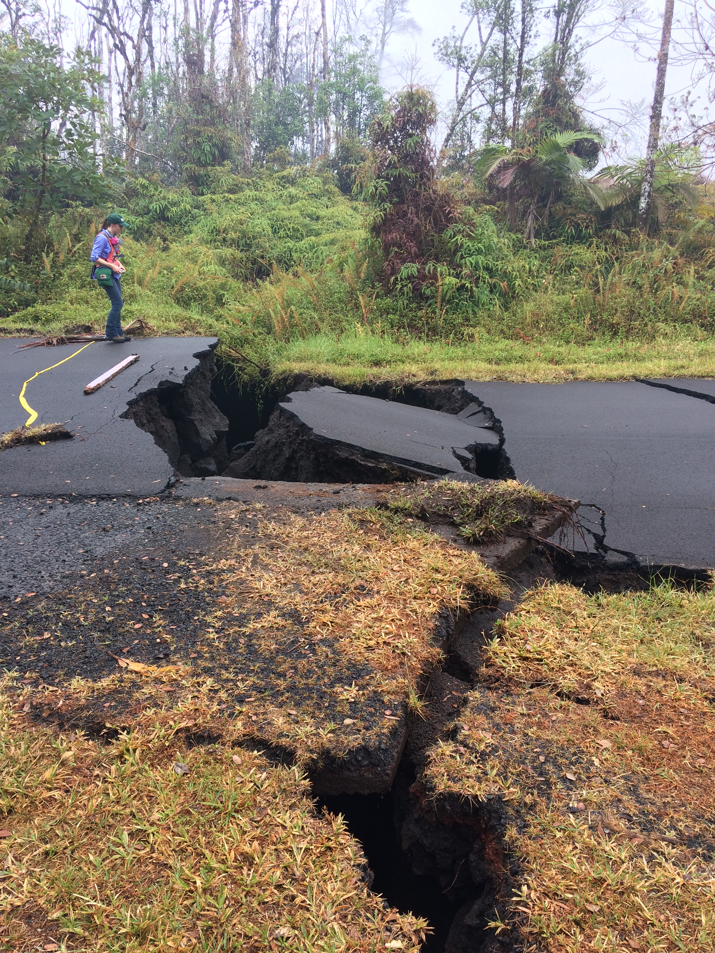
  • Leilani Estates, where fissures started, doesn’t have much erupting now but cracks in some roads are now chasms (photo).
  • Lava is now faster, hotter, more voluminous due to clearing out old lava from 1955 that was pooled under rift zone; now it’s fresh lava from drained Pu’u O’o.

(2) Kilauea Summit Ash Explosions

  • Minor ash explosions continue intermittently at Kilauea’s summit crater, Halemau’ma’u. Between explosions, white plume of steam seen on webcams.
  • This morning, another ash explosion, 10,000 foot cloud, 3:30 AM. Here’s this morning’s Civil Defense ashfall warning with advisory for Kau.
  • See NWSHonolulu on Twitter for ashfall advisories.
  • We don’t know if crater has ejected more “ballistics” (flying rocks) since USGS scientists aren’t risking personnel by entering the possible “flying rocks” zone. Right now they’re working from a temporary base of operations in Hilo.
  • Hawaii Volcanoes National Park remains closed, not only to keep public out of range of flying rocks, but because of earthquake damage to trails and some park structures. These need to be assessed/repaired.
  • Park Rangers have set up in Hilo Bayfront to educate public about this historic eruption.

Oh look, another hazard from lava entering ocean: WATERSPOUTS.

And even when fissures don’t spout lava, they can still be dangerous:


May 21: Daily Roundup, Fire & Water Edition

Mick Kalber’s daily helicopter flyover includes some intense views of the rivers of lava heading into the ocean, and the big complex of fountains— 20? 22? we’re starting to lose track— that have dominated the Lava Livestream With Rooster for the last several days.

May 21 Fissure Map (USGS Maps page)

The USGS thermal scan is very informative, too: an infrared satellite detects heat sources (the whiter the image, the hotter it is), and USGS then overlays it on a daylight satellite image of same area. Result, accurate map of where the main flows are, even when they crust over so the lava inside is hidden:

May 21 Heat map of today’s flows (USGS Maps page)

Below the cut: a digest of the day’s eruption news, USGS updates (summarized), and striking social media images and video clips like this:

Continue reading May 21: Daily Roundup, Fire & Water Edition

May 20: Changeover to “Fresher, Hotter Lava”

Monday night, Meteorologist Malika Dudley explains to the BBC how and why the lava erupting in Puna has changed, summarizing USGS findings:

May 20: Sunday Eve News/Images Roundup

Today’s big activities were: (1) massive lava fountains/flows in the Lower East Rift Zone/Lower Puna, entering the ocean at two points (2 modest ash explosions from Halema’uma’u crater (they looked to me like the 10,000 foot range). I’m going to stop worrying about whether they’re triggered by steam explosions or rockfalls.

Late afternoon HNN update includes footage of lava entry into ocean:

Oh good, Mick’s posted the day’s flyover. Noisy helicopter, incredible views:

Also, the lava livestream continues. Someone posted a screencap with USGS scientists working below Fissure 20, giving a sense of scale:

KITV archived HVO’s afternoon alert:

Continue reading May 20: Sunday Eve News/Images Roundup

May 19 USGS Press Conference on Kilauea’s Explosive Side

BigIslandVideoNews just put up an edited video of Saturday’s USGS press conference. My hero Don Swanson is there. It’s INCREDIBLY informative on what they think is happening at the summit and why they think it’s a repeat of the “much smaller eruptions” of 1924 and not larger ones.

Transcription:

Continue reading May 19 USGS Press Conference on Kilauea’s Explosive Side

May 20: Lava Reaches The Ocean

There’s two lava livestreams on Youtube this morning, same location, Honolulu CivilBeat mostly focusing on Fissure 20,  ~1000 yards away. WXchasing moving camera more often [ETA: WX stream now archived]. HCB said Fissure 17 (3/5 a mile away) has built up a cinder cone 300 feet tall.

Last night, Fissure 20’s lava flow crossed Highway 137 and reached the ocean at 11PM, leaving some Puna residents with one escape route. Filed under “things I didn’t know,” Civil Defense warns of “Laze,” a spray of hot steam, hydrochloric acid, and “fine glass particles” when lava hits seawater.

Also filed under “things I didn’t know”: “Methane gas, produced as lava buries vegetation, can migrate in subsurface voids and explode when heated.” (USGS)

May 18/19: Good Summary of Eruption to Date

USGS aerial view of lava flow, May 19. (full-sized)

Volcanologist Erik Klemetti pulls everything together for us, reviewing how the Leilani Fissure lava eruptions and the summit ash/steam eruptions have progressed.

Link:

Kilauea Eruption Continues: How Long Could It Last?

The eruption at Kīlauea is still captivating the nation, as it should because this volcano hasn’t behaving like this in almost a century. I thought I’d take a moment to step back and review of the main events so far and what it might all mean for Kīlauea and the people who live around the volcano. These eruptions are separated by a long way if you look at the satellite data and should almost be treated at two different events..


Also, here’s today’s CivilDefense briefing and BigIslandVideonews’ splice of afternoon USGS briefing with geologist Carolyn Parcheta plus recent video footage.

Taking from video  (basically telling us which fissures are doing what):

Continue reading May 18/19: Good Summary of Eruption to Date

May 19: Lava, Lava Everywhere

This… is just incredible.

The first two weeks of sputtering fissures, slow-moving flows were prelude. Thursday night, the rivers and fountains of runny pahoehoe lava arrived. Today, Saturday afternoon, the overflight videos are historic.

From USGS (loud helicopter):

Fissures 16-20 joined up this Saturday and are marching towards the ocean, expected to cross Highway 137 tonight. Civil defense warns to keep away from ocean entry, if/when the lava reaches the shore, to avoid “laze.”

From Mick Kalber:

I have no words.

Well, okay, I do. I hope everyone down there is safely away. It’s been a hard day for a bunch of people who can’t go home now.

May 19: Rivers of Lava, Fissure 20 Races for Ocean

HNN posted a brief video recap of some of the incredible lava river/fountains last night, identifying it as Lanipuna Gardens (I wasn’t sure.)

Today, Honolulu Civil Beat just left the camera on, and the lava just keeps coming.

Yep, Rusty the Rooster is still trying to tell us it’s morning.

However, despite using a still from dawn Friday morning showing Fissure 17 at its most glorious, its cinder cone is now much higher than it is.

Late Saturday, HCB Livestream screencap. Fissure 17 dwarfed by its cinder cone now.

Friday night it was incredibly spectacular, but by Saturday the group of combined fountains at Fissure 20 had taken the spotlight, sending vast amounts of Pahoehoe down to the ocean. That said, 17 continued be loud; it’s the one that sounds like a thundering detonation or jet engine in short, loud bursts.

Hazards in Hawaii: Most of the State Is Just Fine, Thanks

I wasn’t going to do this, because hazard information is best left to emergency officials and experts.

But I don’t want the videos and images I’m sharing to mislead people into thinking this event is larger-scale than it is. It’s overwhelming to those who have lost homes or had to evacuate. I don’t want to downplay what they’re going through. At the same time, major hazards are confined to a very limited area, yet news media are whipping this up to apocalyptic proportions and tossing out headlines with “fears” and “anxieties” and “major” to scare people. I don’t want to add to their hype. A volcanic eruption one can watch from a few miles away without dying is moderate, not major.

So let me try to give a rundown of Kilauea hazards, and why I think it’s not greedy nor crazy for officials to be urging tourists not to cancel their visits.

Hazards from the Current Kilauea Eruption

Continue reading Hazards in Hawaii: Most of the State Is Just Fine, Thanks