
Today’s Eruption Summary
Status quo. No significant overflows today from Fissure 8’s lava river. USGS morning overflight put the southern margin of the coastal flow field at 500 m from boat ramp at Isaac Hale Park. In other words, not much movement in that direction.
Summit collapse occurred while I was writing up this post, as expected: 8:54 pm HST, back to an energy equivalent of M5.3 on reviewing readings, they upped this one to 5.5! Let’s see whether that results in an early-morning Fissure 8 surge tomorrow, er, today, Monday.
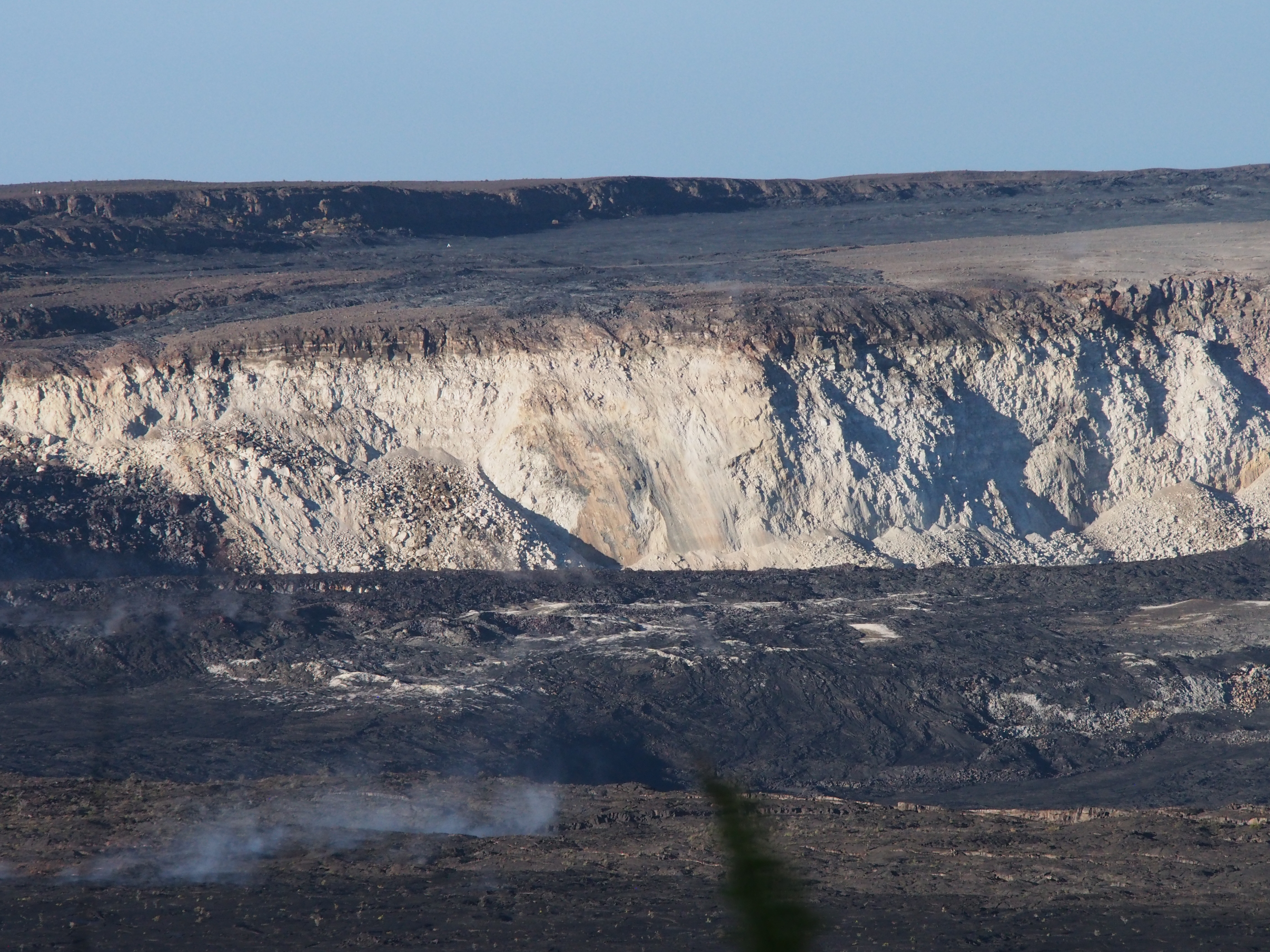
When the National Park opens again, they’re going to have a new— or rather, very old— landmark that I confess I’m rather excited about, although it’s not quite as photogenic as a lava lake. Mark Twain would’ve seen this during his visit in 1866:
As we approach the 3-month mark, the USGS is beginning to supplement its daily reports on the eruption itself with recognition of scientists and support crew who have been working 24/7 to monitor, collect scientific data and inform civil defense and the public since this eruption began. The drone crew worked overtime last night after being grounded by weather then night before:
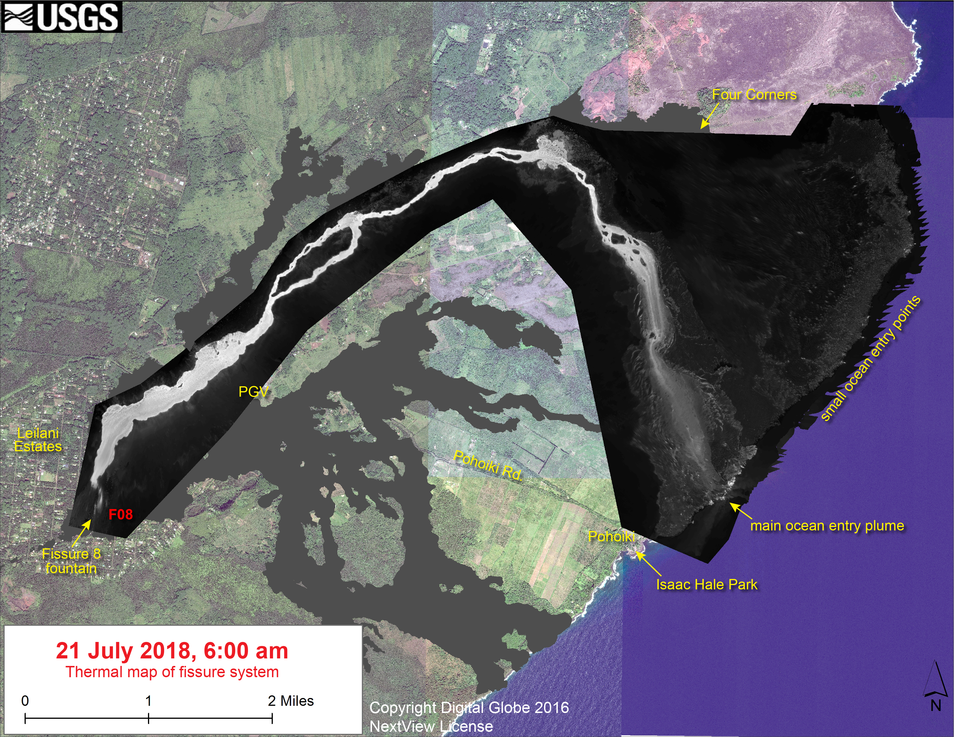
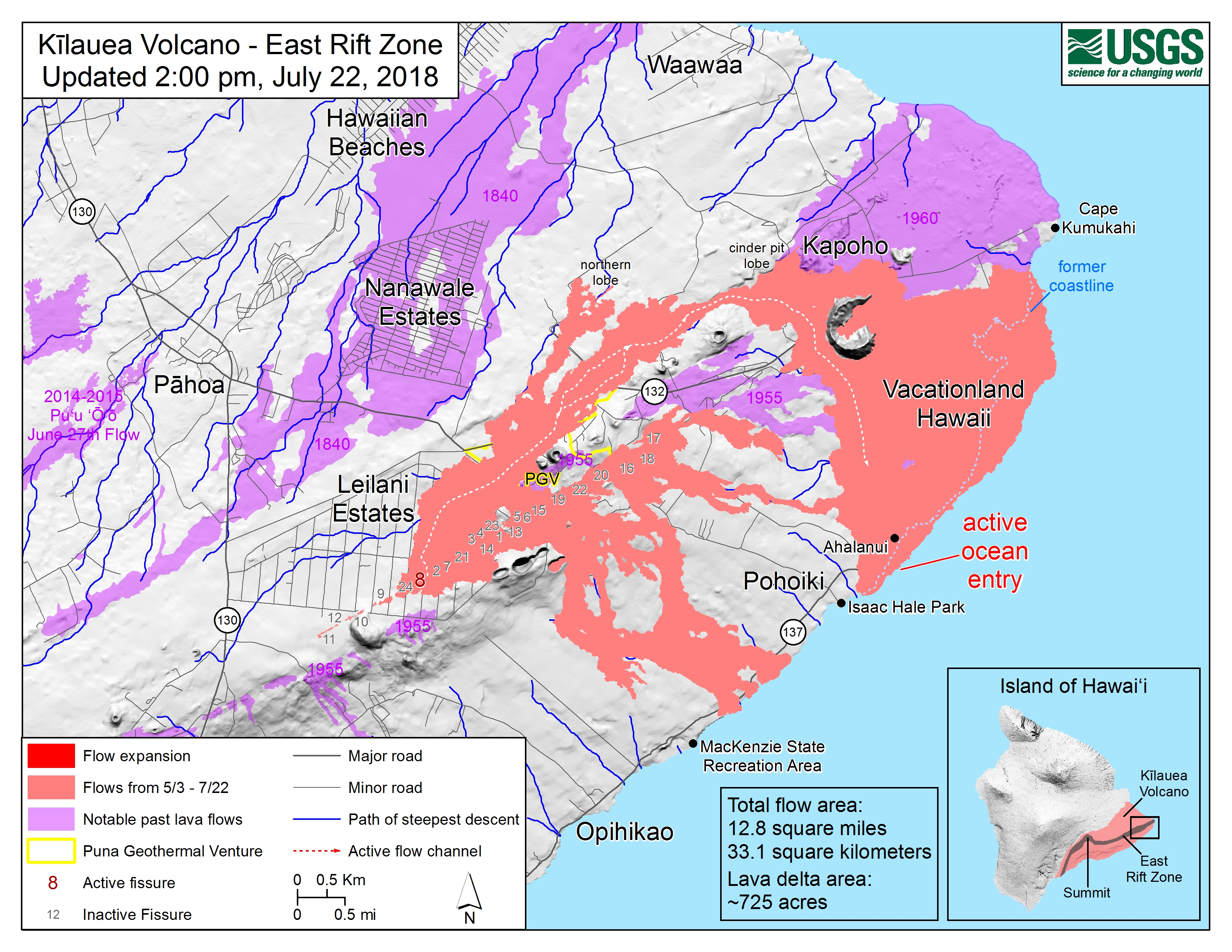
Two maps today, one assembled from yesterday morning’s overflights and one from 2 o’clock this afternoon:

Additional info about thermal map above posted on Facebook:
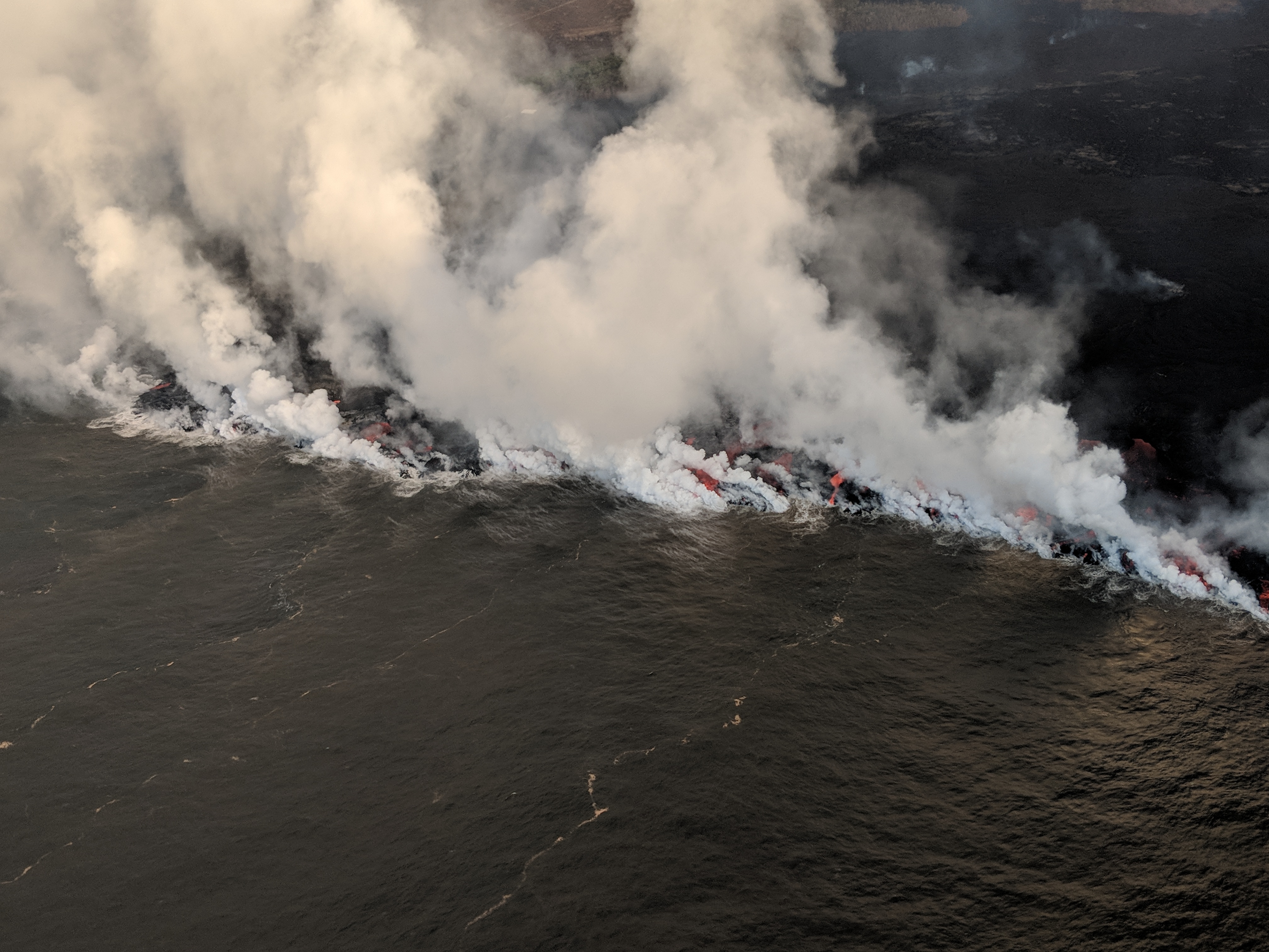
“As shown on the map, fissure 8 is the only active fissure in the lower East Rift Zone. Lava from fissure 8 flows into the established channel that heads northeastward and then turns south near Kapoho Crater. About a mile from the ocean entry, the flow broadens as the underlying topography flattens. The dominant ocean entry is the new lobe that reached the sea near Ahalanui last week. The main channel also feeds small distributary channels (many crusted over) that enter the ocean upstream and downstream of the main channel. A few tiny pāhoehoe toes were observed this morning, entering the ocean from the Kapoho Bay lobe to the north.”
From Local News Media
- WTH: “A perilous beauty” – followup article on lava tour boats
- HSA: “Lava-affected voters to share polling place“
- HNN: “Red Cross shelters still home to dozens of lava evacuees over 2 months later“
- HSA: “State cancels purchase of land engulfed by lava“
- BIVN: (Video and article) “Second Insurance Forum Held in Pahoa“
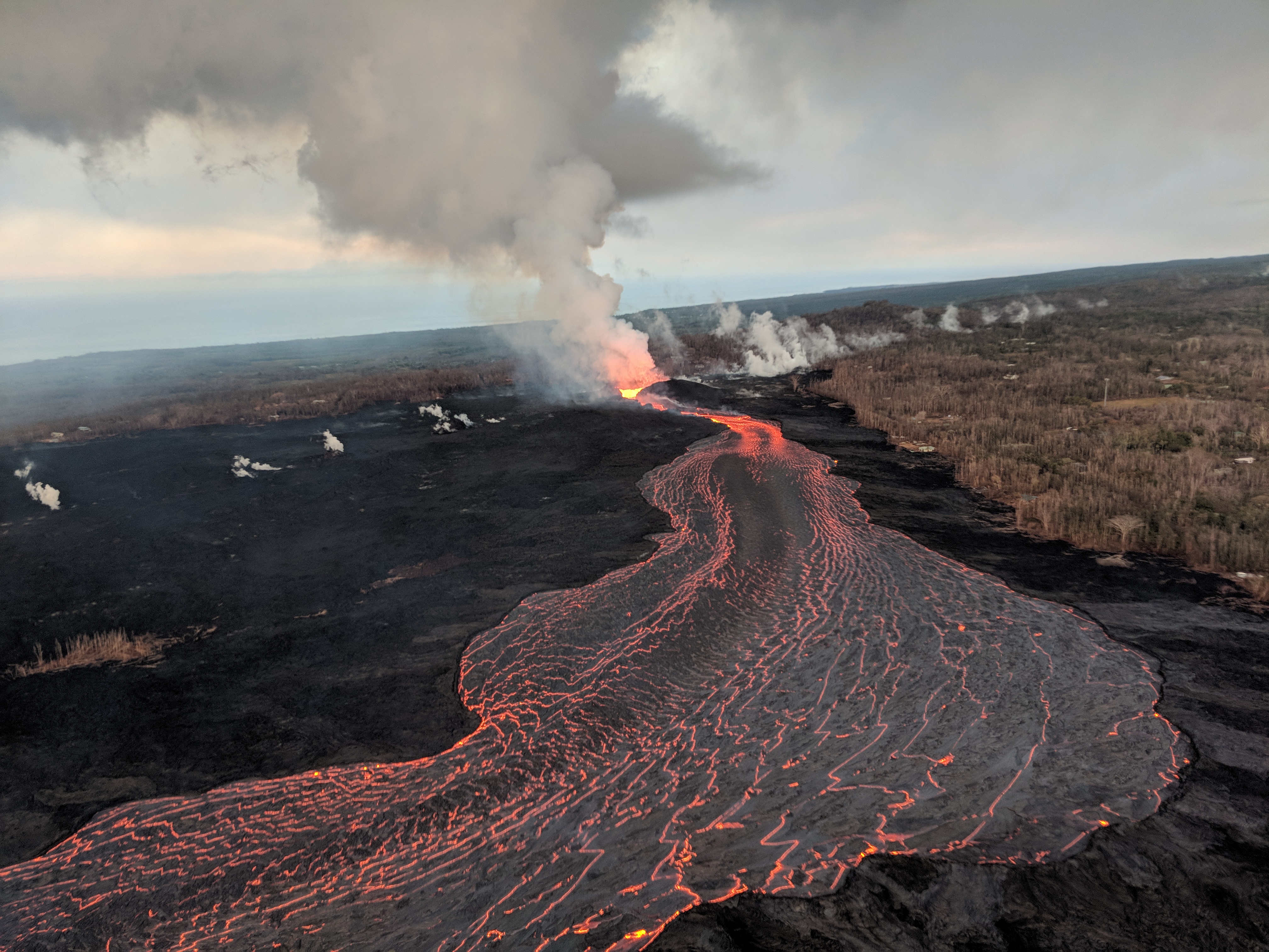
- And Bruce Omori posted morning overflight observations on Facebook (sigh) including a few details USGS didn’t mention. A few of the 18 photos attached to this post:
Sunday, July 22, 2018, 6:00 am – Kilauea's lower east rift zone overflight: A column of rising steam spun wildly,…
Posted by Extreme Exposure Fine Art Gallery on Monday, July 23, 2018
Sunday, July 22, 2018, 6:00 am – Kilauea's lower east rift zone overflight: Kapoho Crater and the channelized ‘a‘a flow bypassing it to the northwest.
Posted by Extreme Exposure Fine Art Gallery on Monday, July 23, 2018
Posted by Extreme Exposure Fine Art Gallery on Monday, July 23, 2018
Posted by Extreme Exposure Fine Art Gallery on Monday, July 23, 2018
Rest of photos here. Looks like there were a few early morning overflows, but none extending past existing flow field.
USGS Q&A on Social Media
That's right! Even though they're not actively erupting, the other fissures are still hot, and in the morning we often see those steam plumes issuing from all of them. They tend to dissipate later in the day.
— USGS Volcanoes🌋 (@USGSVolcanoes) July 23, 2018
Q: [Would you share a little background info on Kapoho Crater?]
USGS: It’s about 400 years old – give or take – and contained a chain of small craters, pyroclastic deposits (ash and broken rock), and an a’a flow. One of those craters used to contain Green Lake. (You can read more on p. 326-327, V1 of “Volcanism in Hawaii”: https://pubs.usgs.gov/pp/1987/1350/ )
Q: [Is there a chance another lake might form there?]
USGS: There is, yes. The recent lavas are pretty porous, so it might take some time, though.
Q: What’s feeding Fissure 8?
USGS: Magma is moving from Kīlauea’s shallow summit reservoir, draining out and through the south caldera reservoir and then out to the rift zone – traveling about 26 miles from the summit to fissure 8 in the lower East Rift Zone.
The reason is that the more viscous (pasty) kind is what was left in the Rift Zone from a previous eruption – maybe even the 1924 intrusion – and was pushed out in advance of the more fluid lava that drained from Pu'u O'o and the summit.
— USGS Volcanoes🌋 (@USGSVolcanoes) July 22, 2018
[Readers to my blog already know all this, but I love that description of “slow thick slug lava.” I wonder if this person is mistaking lava/seawater interactions, li.]
Q: How much of laze is water vapor?
USGS: A pretty large portion. We don’t know actual percentages. In general, a big part of any volcanic plume is made of water vapor.
Q: [Same questioner tries again.]
USGS: At least 80%, but probably even more at the ocean entry.
Q: [Are there downwind impacts of steam at ocean entry?]
USGS: The laze (lava+haze) plume impacts are largely local. There has been a lot of weather (heat-generated cumulonimbus clouds) over the ocean entry and Leilani Estates area, so the eruption is causing rainstorms.
Q: [Complaint that they can’t accurately predict when the volcano will start/stop erupting. (Although HVO did give advance warning an eruption was imminent!)]
USGS: That is the nature of volcanoes. Kilauea has one of the longest monitoring records in the world, but that doesn’t stop it from doing unexpected things. We can make short-term forecasts based on our monitoring data and our knowledge of the past, but those aren’t crystal balls!
[I don’t know why people expect volcano forecasts to be more accurate than weather forecasts. It’s pretty much the subterranean equivalent of weather, except there’s rock in the way, so volcanologists have to guess where the “clouds” and “currents” are that are causing the “rain.”]
Q: [Early afternoon – There seems to be steam condensing over Kilauea summit: is water seeping into conduit?]
USGS: It’s not related to water in the conduit – it’s a result of rising hot air in a humid atmosphere. As hot air rises and cools, the water it contains condenses into clouds. We’ve seen it before in the afternoon at the summit.
From Photographers & Social Media
I have a feeling I’ve posted this famous photo before, but I never get tired of it.
A 1,000-foot lava fountain in the Mauna Ulu vent area of Kilauea, Hawaii, on December 30, 1969. pic.twitter.com/NNAbQBeSnT
— History Photographed (@OldHistoryPics_) July 23, 2018