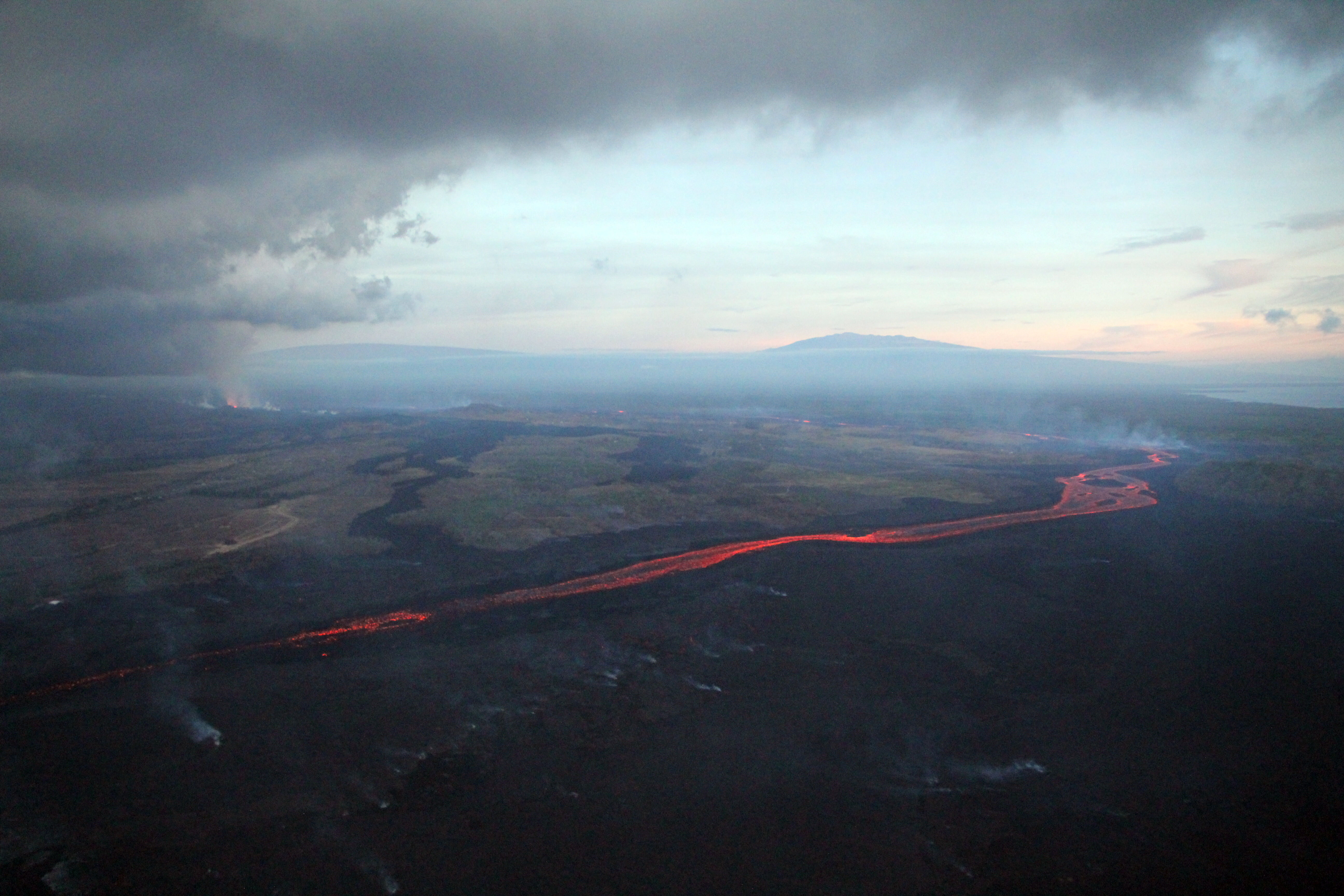
July 20, 2018. USGS: “During their early morning overflight, USGS scientists captured this view showing three of the five volcanoes that comprise the Island of Hawai‘i: Mauna Loa (distant upper left), Mauna Kea (distant right), and Kīlauea (foreground), with the fissure 8 vent and channelized lava flow on the volcano’s lower East Rift Zone.” (Full-sized)
Today’s Eruption Summary
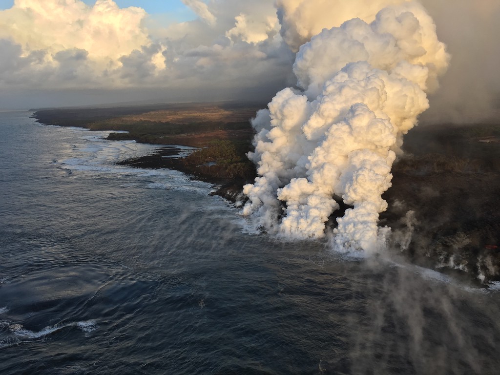
The Lower East Rift Zone eruption continues as per usual. USGS reported during today’s morning overflight that “the channel was incandescent its entire length from vent to ocean entry.” There’s a main ocean entry a few hundred meters NE of the southern flow border with smaller pahoehoe flows on either side. The southern margin doesn’t seem to have advanced much from yesterday.
July 20, 2018. USGS: “An aerial view of the southernmost ocean entry lava lobe. As of 6:30 a.m. HST, the south margin of the lava flow had not changed since yesterday, and was about 500 m (0.3 mi) from the boat ramp at Isaac Hale Park.” (
No other fissures are active, and I already covered yesterday’s 4:33 HST collapse event. I’m betting the next one will be after dark.
State Highways have put a speed limit of 25 on Highway 11 between Mile Marker 28 and 30 due to cracks in the road.
Janet Babb, Kīlauea Update: Good afternoon, everyone.
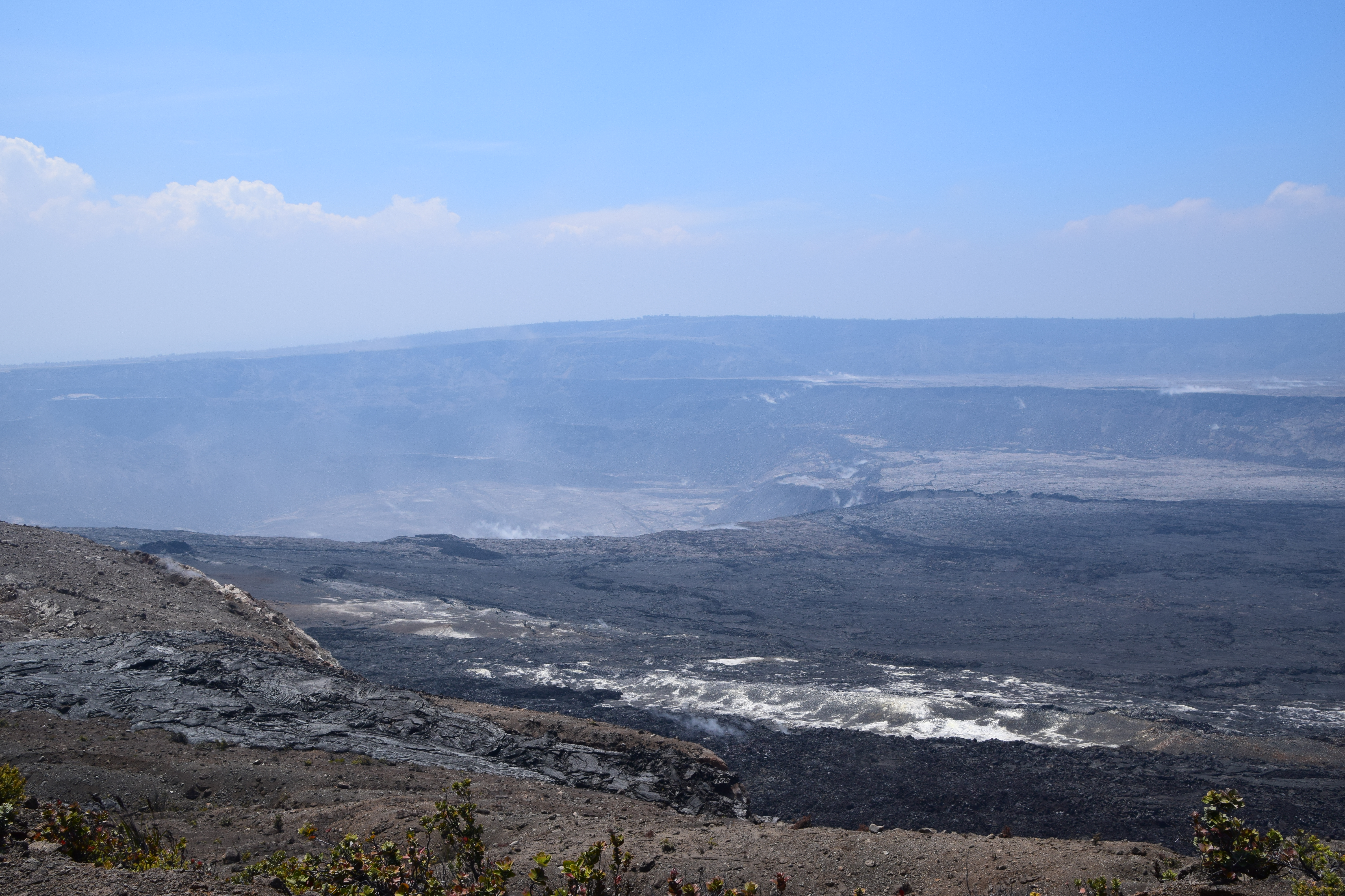
On the Lower East Rift Zone, Fissure 8 is still active. It continues to erupt lava into the perched channel that extends down on the west side of Kapoho Crater and feeds lava into the ocean. This morning, the main ocean entry was a little bit west of Ahalanui, with the flow margin about 500 meters, or 0.3 mile, from the Pohoiki boat ramp. There’s still some weak ocean entry points to the north of this main entry over near the Kapoho Bay lobe of lava where there were some weak, wispy plumes there. The flow front along the ocean, along the coast is still about 6 kilometers wide or 3.7 miles wide. On the Lower East Rift Zone, the sulfur dioxide emissions remain high, and the ocean entry hazards include the laze plume, as well as the possible hydrovolcanic explosions, what we referred to on Monday as “littoral explosions.” Hydrovolcanic is a little more intuitive word to explain the lava-seawater interaction.
Up at the summit, as we speak earthquakes are occurring at a rate of about 25-30 per hour as the volcano builds up to the next collapse event [this phonecall at 1 pm, collapse came at 4:33 pm.] The previous collapse event weas at 1:28 am July 18, so it’s been about 36 hours. We are within that time interval where we typically see these collapses occur. At the summit, the sulfur dioxide emissions are low. We’ll be posting some new photos and a new map shortly after this media call. That’s all.
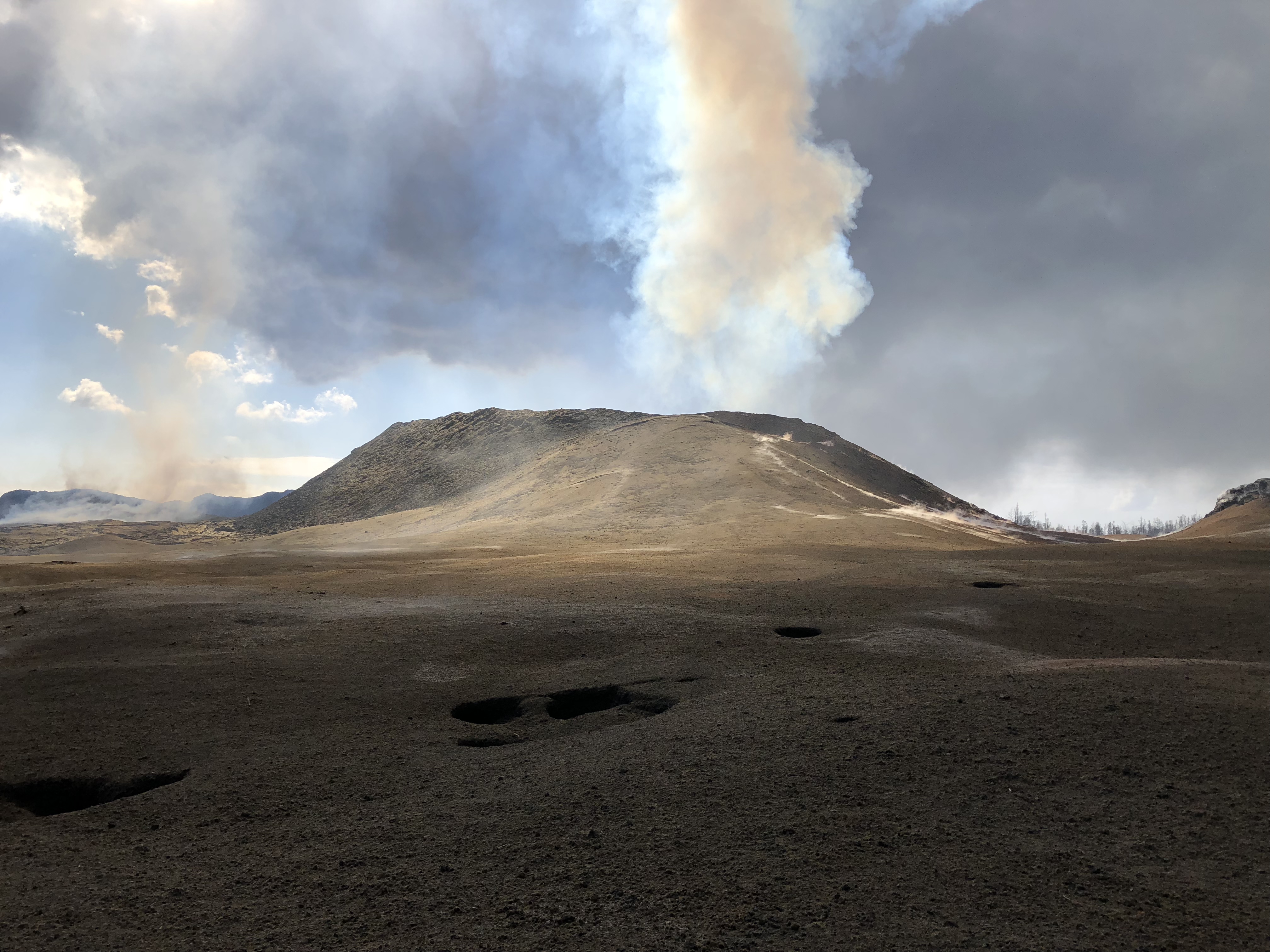
July 19, 2018. USGS: “Volcanic gases rising from the fissure 8 vent and lava channel feed a pyrocumulonimbus cloud above the tephra cone. Small pits in the tephra deposit (foreground) form when the lava fragments collapse into cracks and void spaces below the surface.” (Full-sized)
Today’s Eruption Summary
As per usual. Fissure 8 continues to feed the lava channel down to the ocean, where the southern margin of the flow was 500 m from Isaac Hale Park this morning. Lava levels in the channel this morning were low, with the previous collapse event coming at 1:28 am the day before.
July 19, 2018. USGS: “An aerial view looking south, with the fissure 8 lava channel on the west side of Kapoho Crater, visible at left. As it nears the ocean, the channelized lava transitions to a broad ‘a‘ā flow that spreads laterally and toward the coast. The ocean entry plume is barely visible in the far distance (top).” (Full-sized)
Today’s summit collapse event occurred at 4:33 pm.
July 19, 2018. Collapse event tweeted by USGS: “Hereʻs a photograph from the 4:33PM #TypeA collapse event from #Kilauea summit. Rockfalls occurred from near-vertical cliffs around the #caldera and #Halemaumau.” (Full-sized)
WHT: “Fire sparked during RIMPAC exercises consumes 2,000 acres” – As I suspected. Those fires on the saddle between Mauna Loa and Mauna Kea which prompted the usual “Is Mauna Loa erupting?” questions were started by military training exercises.
Mick Kalber Overflights
Mick posted yesterday’s June 18 overflight (good views, including that lava flow moving over a still-active but slower flow) and notes as well as today’s:
Q: [Is Cape Kumakahi still the easternmost point of the island?] USGS: The area off Kapoho has a paltry supply of lava now – unless significant lava returns, the eastward advancement may cease.
Q: [Has there been any change in temperature of lava, now that it’s crusting over and/or not a fluid channel all the way to the ocean? Any sign eruption is ending?] USGS: No, the temperature remains the same. Other factors are probably responsible for the crusting – blockages, flow velocity, precipitation, etc. Sometimes the channels remain fluid, and sometimes the surface can crust over – but that doesn’t mean there isn’t lava moving beneath the crust… No, no signs that the eruption is ending yet.
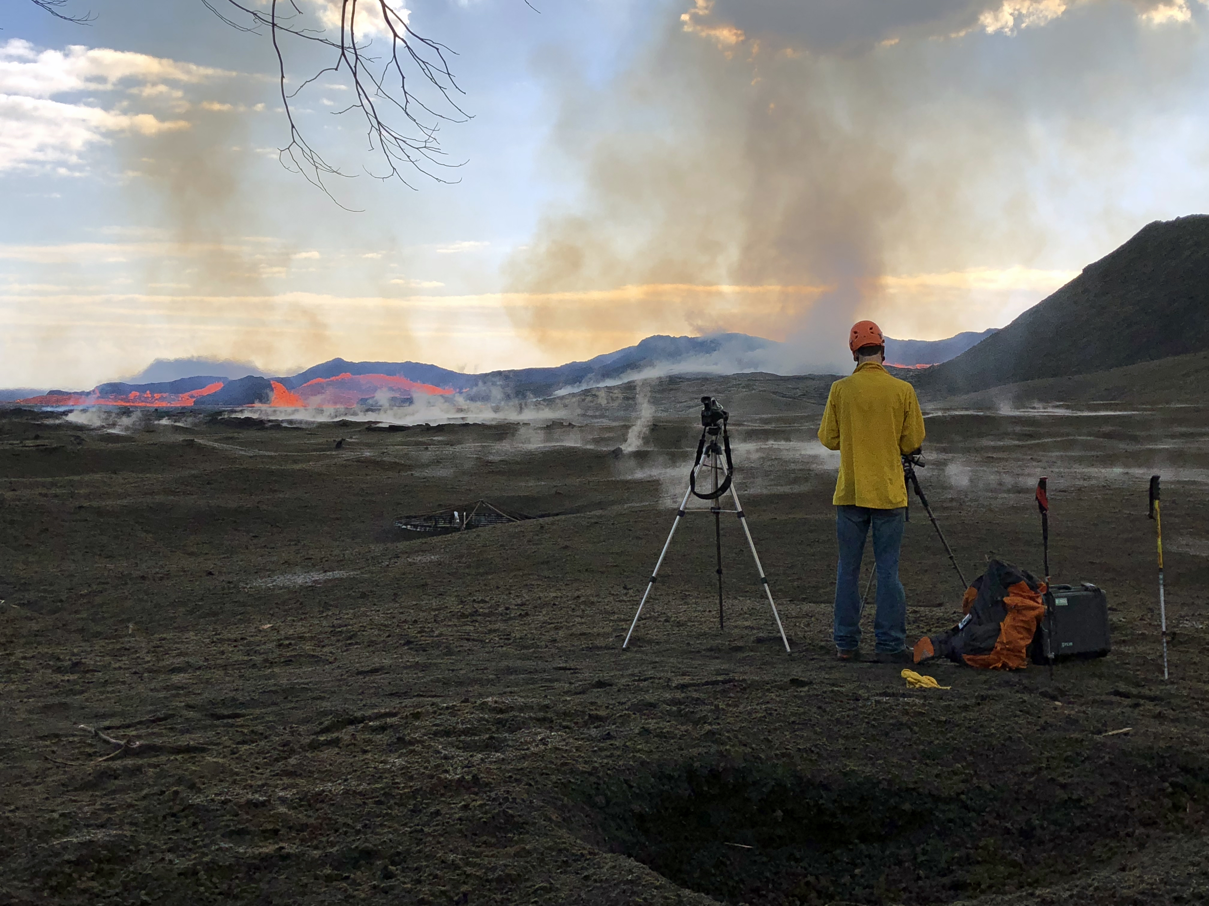
July 19, 2018. USGS: “his HVO geologist is standing on tephra (airborne lava fragments, such as Pele’s hair) that was erupted from and deposited downwind of the fissure 8 vent. He was there to observe the vent activity and to capture both thermal and video imagery of the pulsations occurring in the near-vent channel. The frame of a water catchment tank cover can be seen in the tephra deposit to the left of the geologist’s camera and tripod (center).” (Full-sized)
Q: [Someone asking about webcams and livestreams] USGS: We weren’t able to adjust the bandwidth on the cam from HVO, but we did add the stream from the northeast caldera, which uses a different (and still challenged) connection.
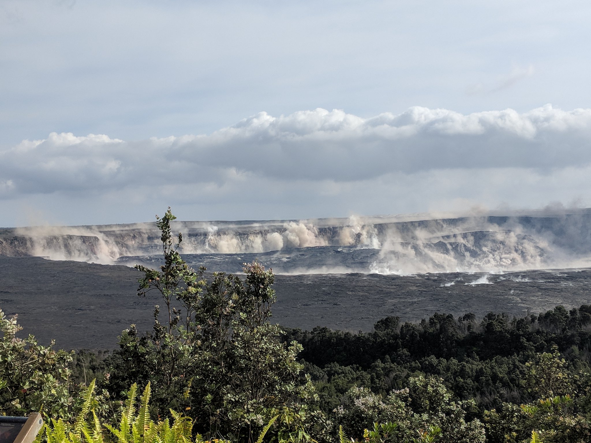
July 19, 2018. USGS: “Numerous rockfalls have occurred within Halema‘uma‘u and along Kīlauea’s summit caldera walls today, stirring up existing ash deposits and rock dust, and creating sounds that, at times, could be heard from the northeast rim of the caldera.” (Full-sized)
Q: [Cinder cone is 120 feet now? Was 180; has it collapsed?] USGS: Some settling has occurred, and some of the more precarious bits have probably fallen in or down the slopes. [Same basic question, different day] USGS: Yes it has succumbed to thermal erosion, collapse, and settling. There have been no sustained fountains depositing material on its outer slopes for several weeks, so there has been no additional accumulation of tephra.
Vladimir Vysotsky on FB: USGS Volcanoes: you keep characterizing this as a “perched channel”. I wonder if that is how lava tubes form – a channel builds the foundation and walls around itself, then crusts over while still flowing inside, and eventually forms a tube when the lava finally drains. Is that a correct assumption?
USGS Volcanoes: That is a very accurate description of lava tube formation! ][…] Hereʻs a video from Hawai’i Volcanoes National Park describing what you d[id] with video footage to accompany for visual reference. https://www.nps.gov/media/video/view.htm...
Q: [Is Fissure 8 how Diamond Head formed?] USGS: – Diamond Head is a tuff cone that erupted through water. It is also considered “rejuvenation stage” volcanism. The eruption that formed it occurred after the Koʻolau Volcano (from where it erupted) had been dormant for about 2 million years! http://volcano.oregonstate.edu/post-erosional-rejuvenation
July 19, 2018. USGS: ” An aerial view looking to the west, near the braided section of the fissure 8 lava channel. During this morning’s overflight, the channelized lava was at a lower level than usual, but was still being fed by vigorous outflow from the vent.” (Full-sized)
Q: [How long will this go? How will it end? Does a lava flow normally start slowing down and then stop?] USGS: This could go on for any number of days, honestly. Typically these things don’t just turn off and stay turned off. We expect that activity in Fissure 8 will wane, then stop and start again (perhaps at other fissures). However, the eruption won’t stop all together until the pressure driving the magma out of the ground has been relieved.
Q: [How deep is lava channel?] USGS: We have tried to calculate depths based upon lava-flow observations within the channel and known depths of dormant channels on other locations in the Hawaiian islands. The channel is meters in depth, but likely not more than 10. Depth varies throughout its length as well.
[In discussion that Fissure 8 is not a volcano— it’s a vent on Kilauea’s flank just like Puʻu ʻŌʻō was, with magma being piped down from Kīlauea’s magma storage system— someone brought up Lō‘ihi, which IS a new volcano (or seamount) off SE coast of Big Island, still underwater.]
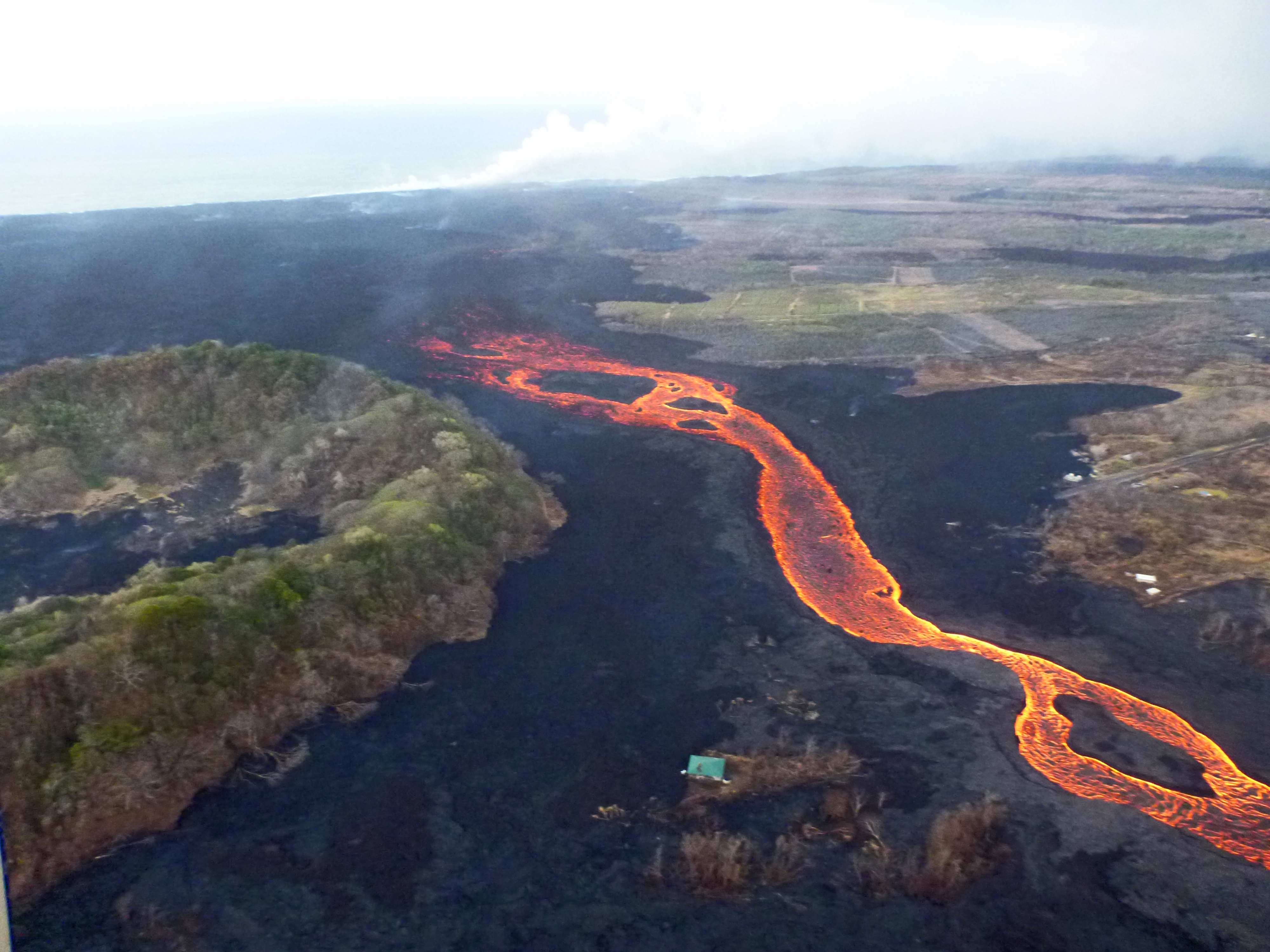
July 19, 2018. USGS: “As of this morning, the southern margin of the fissure 8 ocean entry was about 500 m (0.3 mi) from the boat ramp at Isaac Hale Park.” (Full-sized)
Q: [Is the summit caldera sitting on the magma chamber?] USGS: The subsidence area within the caldera essentially overlies the area of the shallow magma storage region that fed the lava lake in Halemaʻumaʻu. So, yes. Q: [Could the floor collapse into the chamber? What would happen then?] USGS: Technically speaking, the floor, and everything that was between it and the top of the chamber, is collapsing into it. Youʻre seeing the outcome – pressure drops and collapse events that manifest as M5.3 earthquakes.
Things too obscure to bug USGS about: why is it “littoral” when the Latin word for seashore has only one “t”? [Checks etymology: ah, yes, it’s a Medieval Latin spelling.)
Here’s a transcript of this week’s presentation from HVO Deputy-Scientist-in-Charge Steve Brantley at the Tuesday Pahoa Community Meeting.
I’m going to start with a broad overview of the eruption so far. We’re 80 days into the eruption [since the floor dropped on Puʻu ʻŌʻō, I think] about now, so I want to provide a little bit of context, in terms of similar activity or un-similar activity in the past 200 years. And then we’ll do a quick summary of what’s happened in the past week.
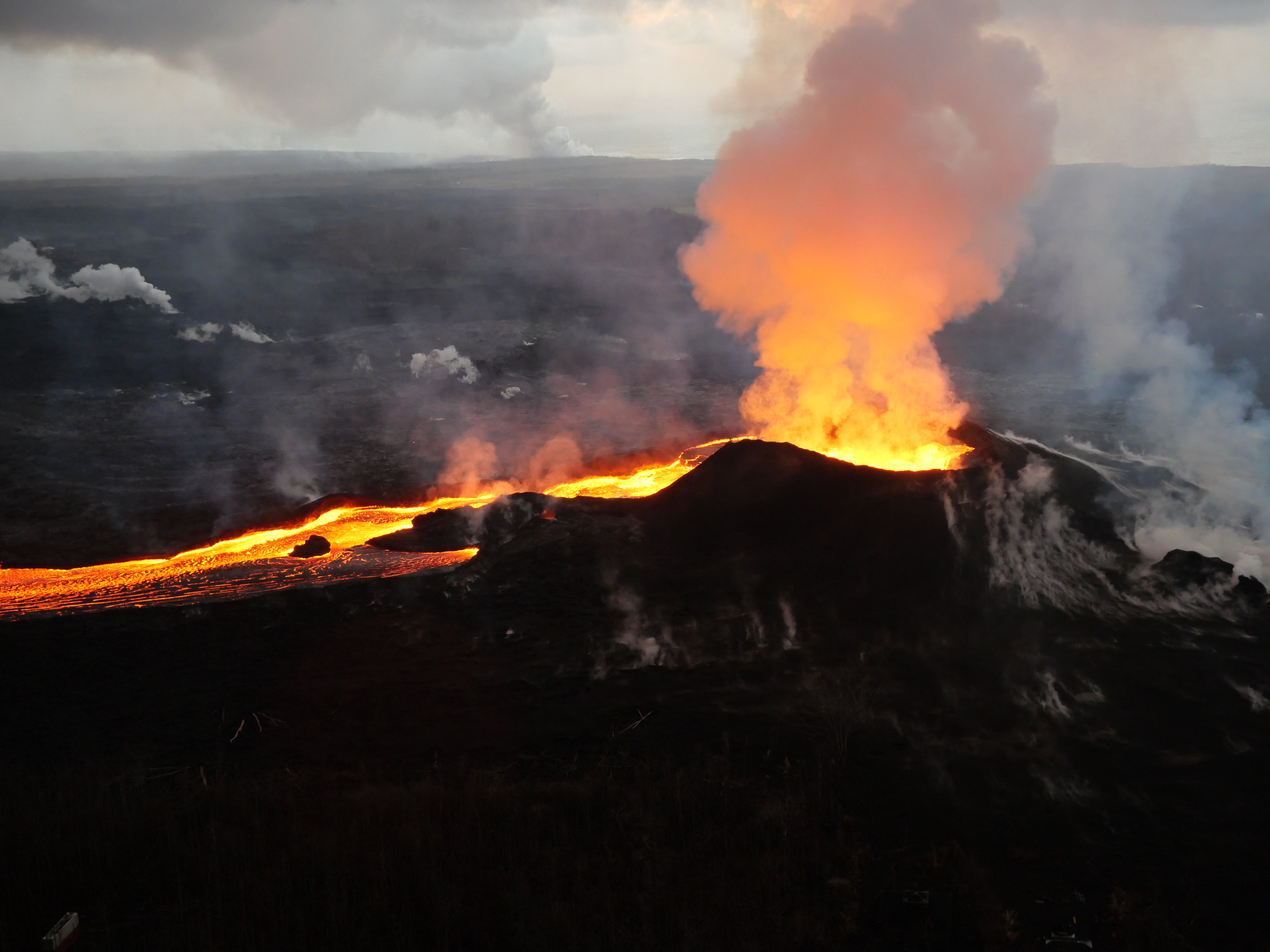
July 18, 2018. USGS: “The fissure 8 cone (right) and proximal lava channel were partially obscured by volcanic gas emissions this morning. In concert with surges in the eruptive activity, lava levels were fluctuating over periods of about five minutes. Deposits of tephra (airborne lava fragments, such as Pele’s hair) blanket the foreground area.” (Full-sized)
Today’s Eruption Summary
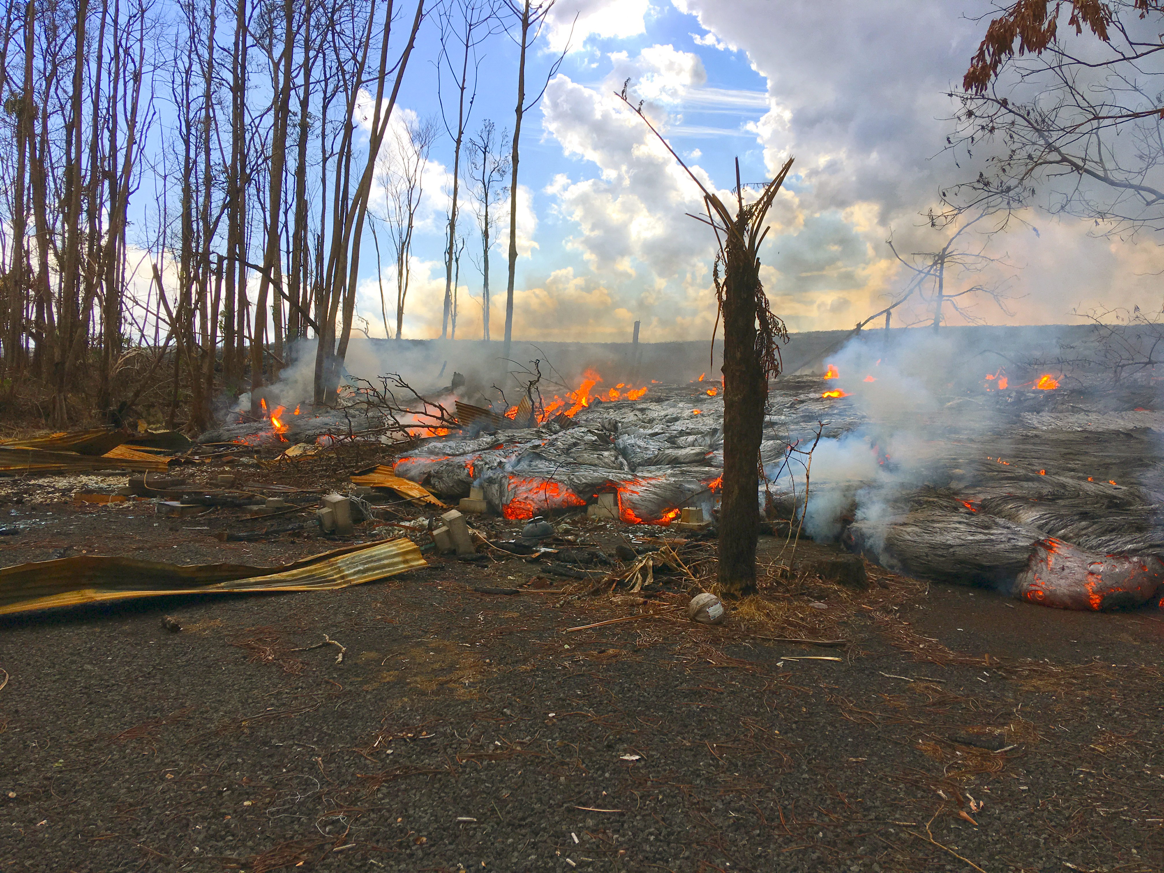
Fissure 8 surged after last night’s summit collapse and sent brief-lived overflows towards Nohea Street and on both sides of the channel further down. Civil Defense reported an unspecified number of structures lost; Janet Snyder of the Mayor’s office said one in the mandatory evacuation zone of Leilani Estates.
Other fissures remain quiet.
July 18, 2018. USGS: “An increase in lava supply overnight produced several lava channel overflows that threatened homes on Nohea street in the Leilani Estates subdivision; farther downstream, lava overflowed both sides of the channel. By mid-morning, the overflows had stalled (flow shown here). For scale, a person’s leg and boot are just visible on the right center edge of this photo.” (Full-sized)
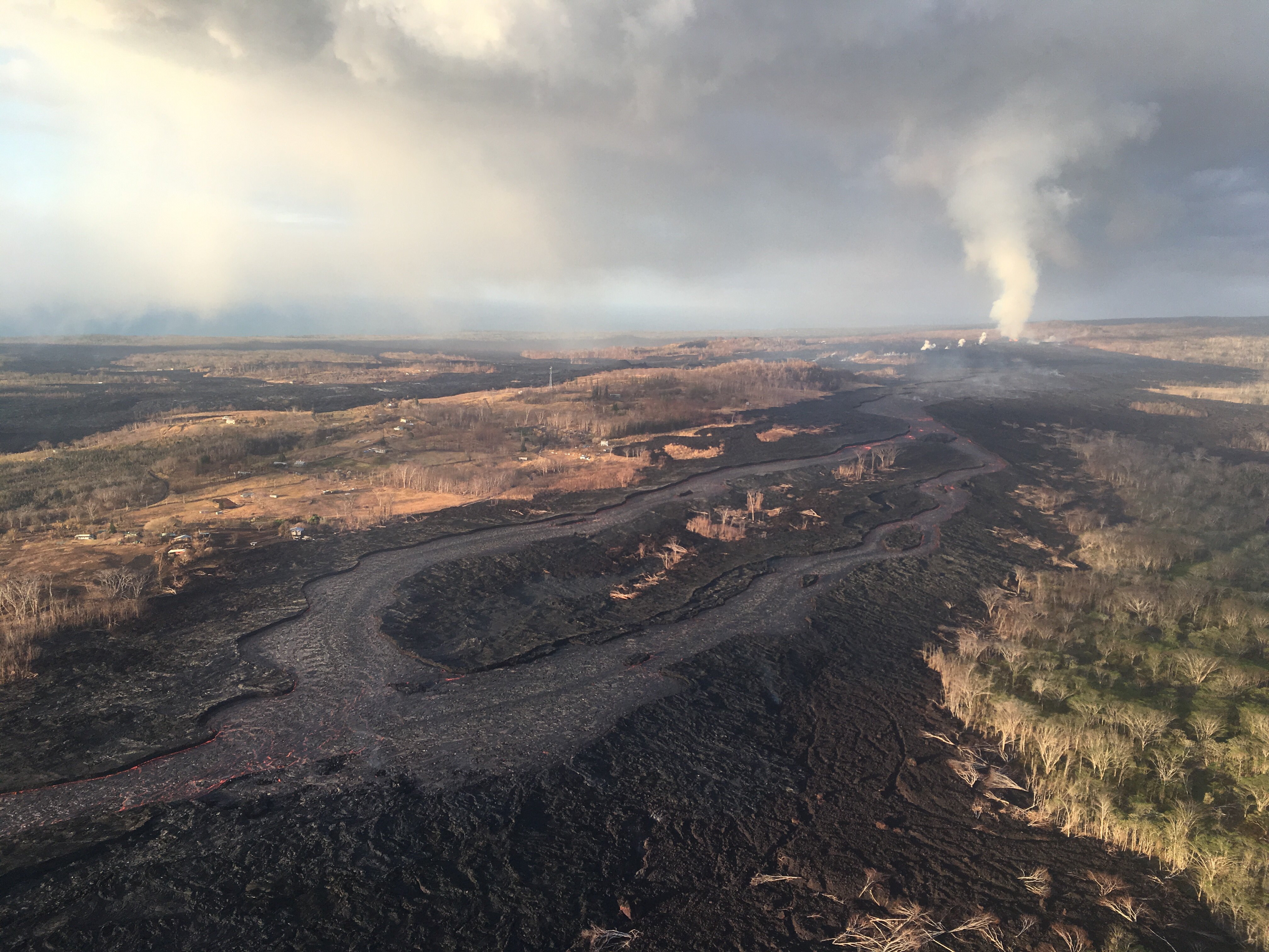
Past Kapoho Crater, a pulse of a’a made its way to the ocean, overriding the existing channelized flow on the south side of the delta. Ooze-outs continue here and there along the edge of the delta.
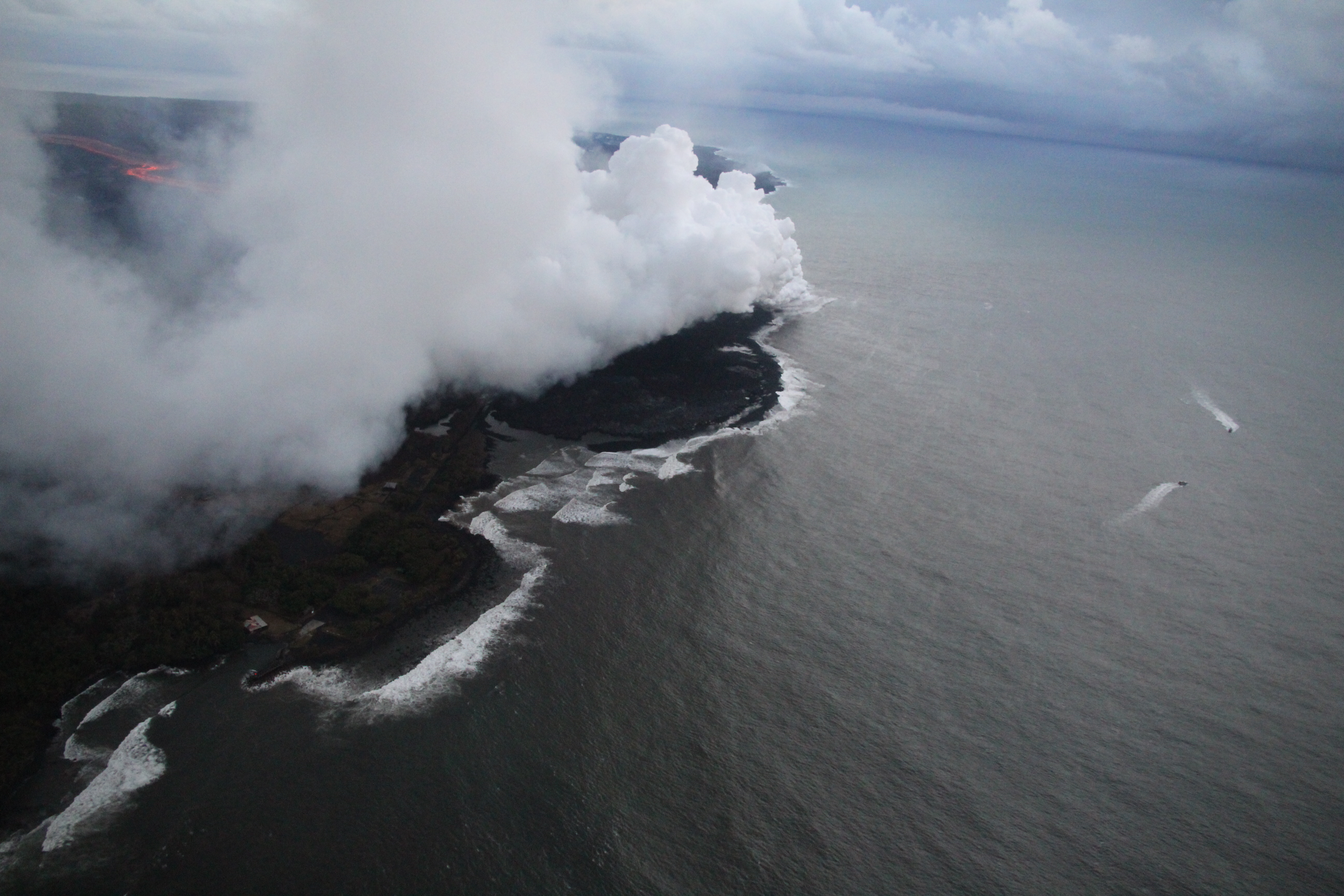
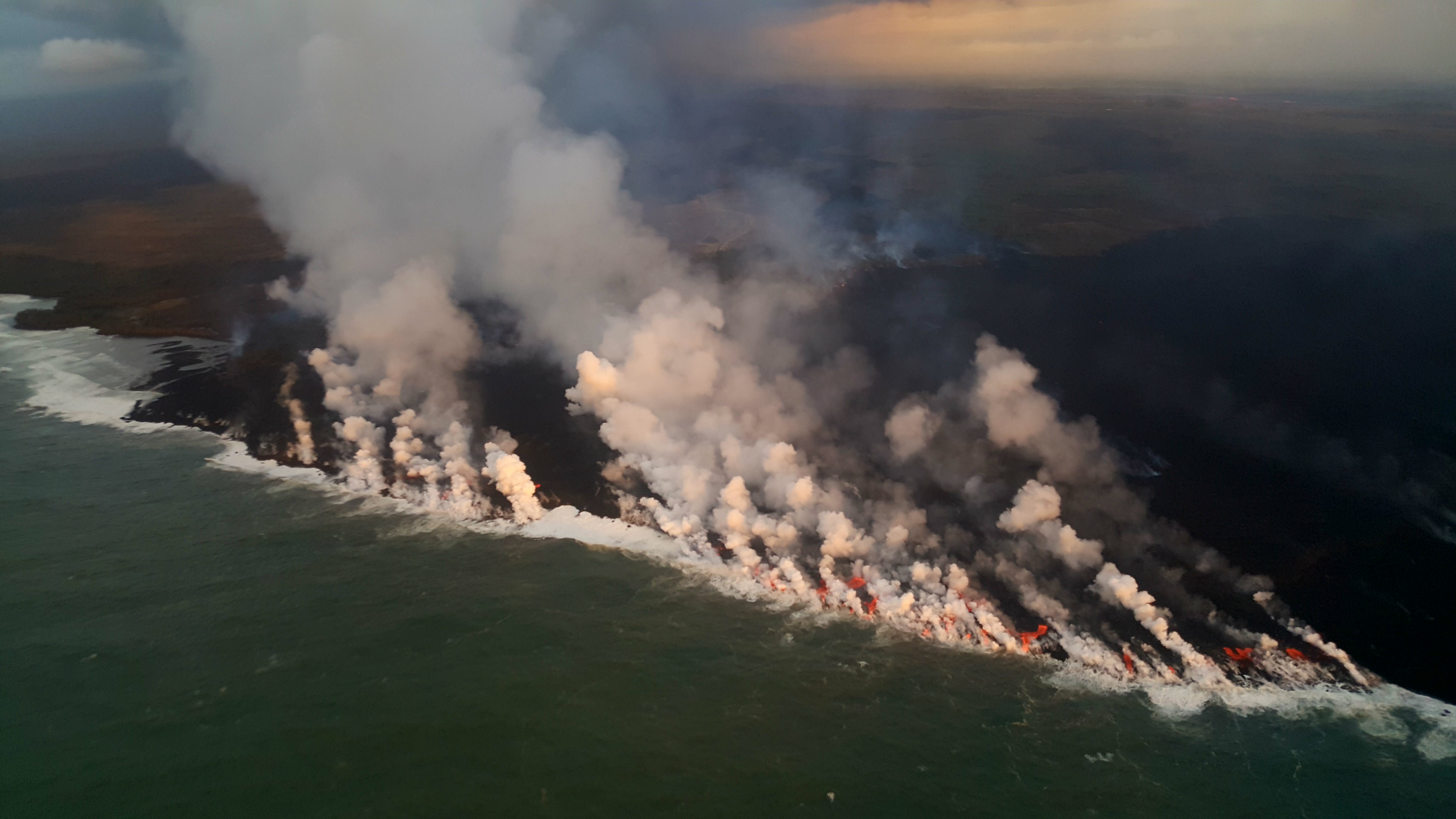
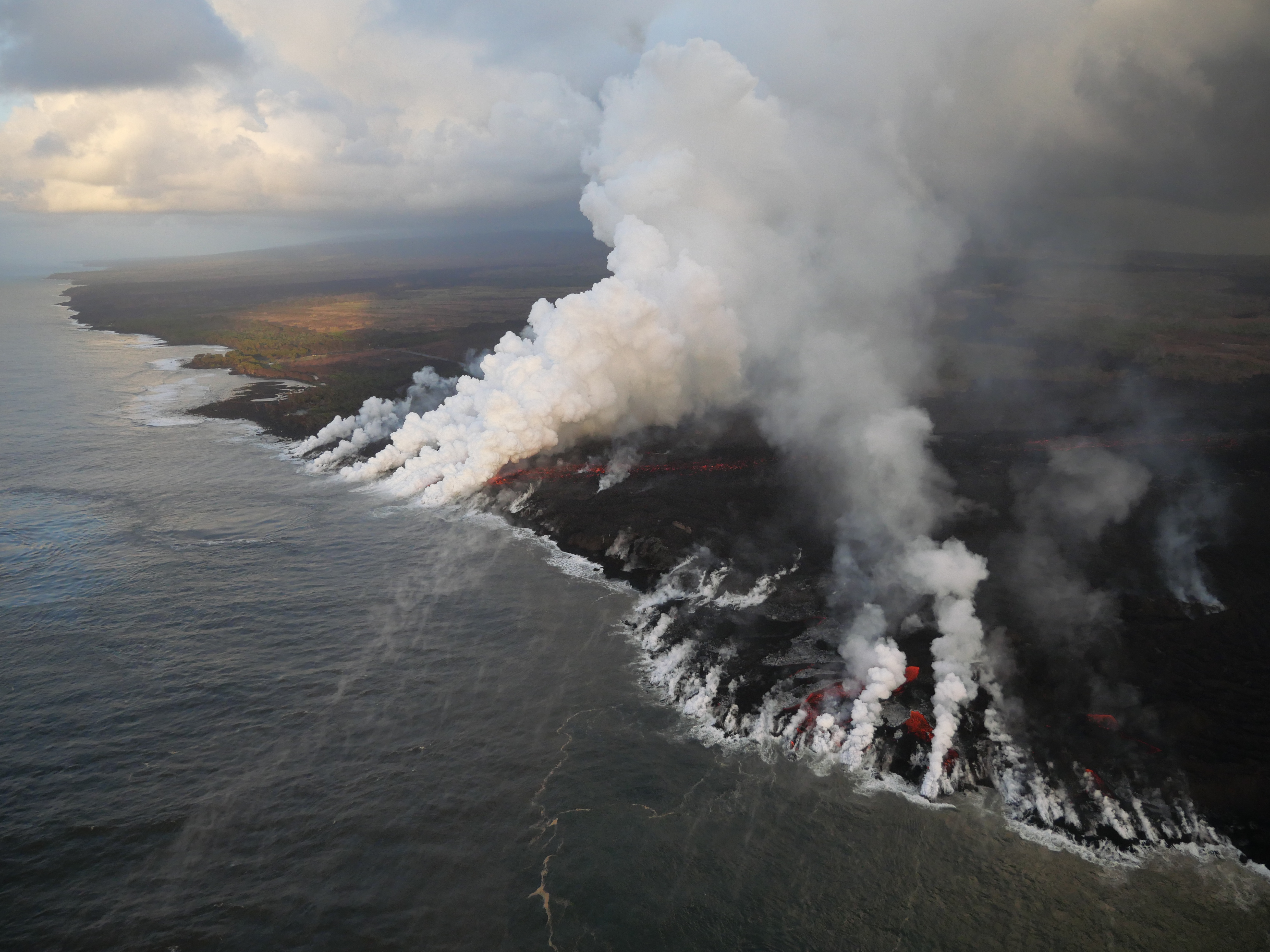
July 18, 2018. USGS: “Several lobes of fissure 8 lava are entering the ocean along a broad front, with the southwestern edge of the entry shown here. The southern margin of the lava flow was about 700 m (0.4 mi) from the Pohoiki boat ramp this morning.” (Full-sized)
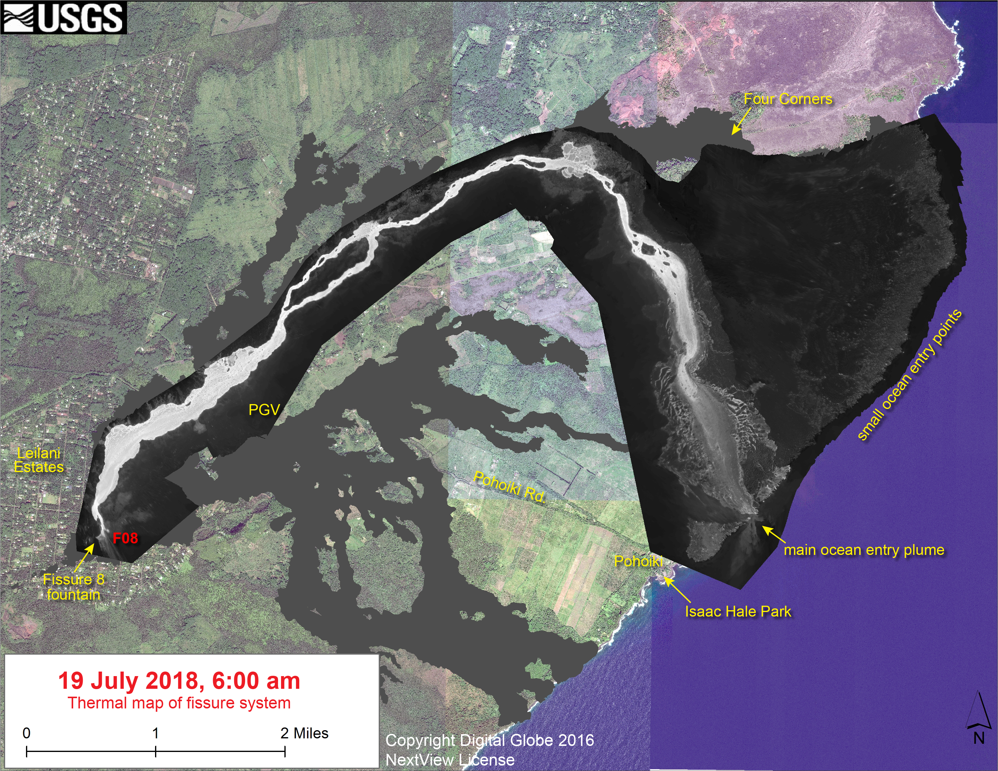
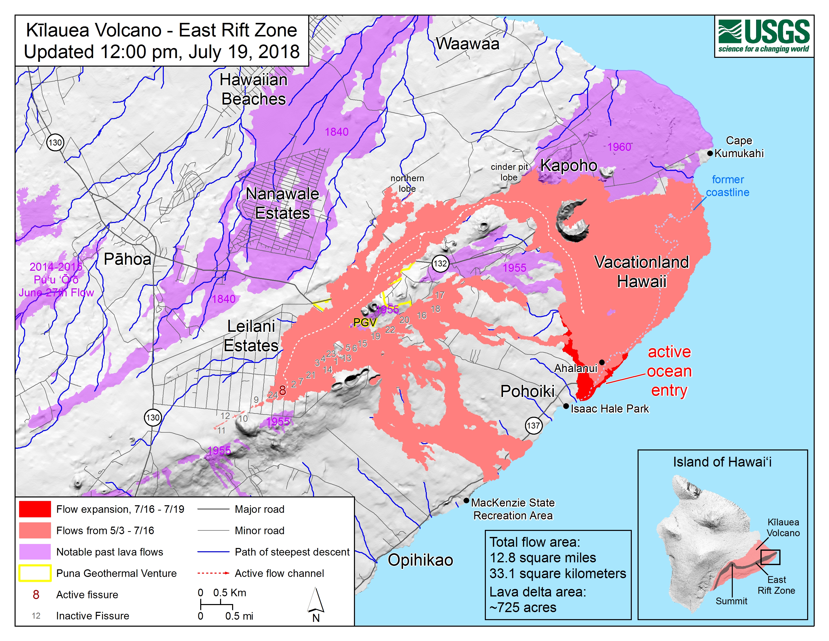
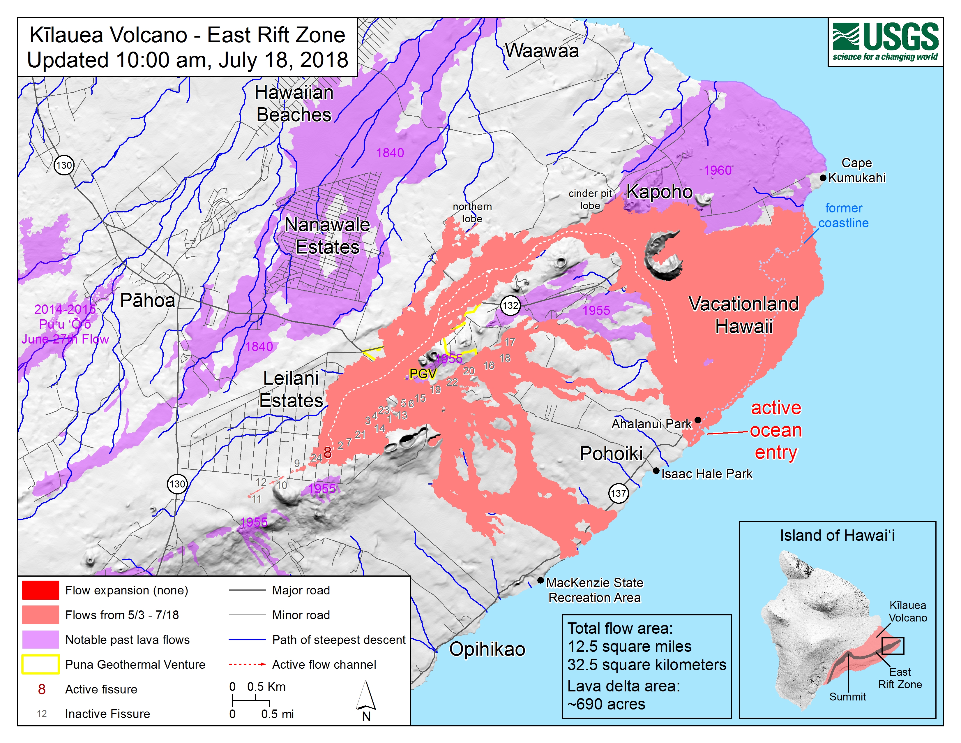
July 18, 2018. USGS: “Map as of 10:00 a.m. HST, July 18, 2018. The south ocean entry area was obscured by laze (acidic steam plume), so the southern boundary of the lava flow is approximate on this map.” (Full-sized)
And the smoke from a fire on the saddle area of Mauna Loa this evening is NOT a volcanic eruption.
July 15, 2018. USGS: ” View of fissure 8 looking uprift toward the west. The open lava channel in upper right leads to the ocean; when the photo was taken this early morning, nearly all of the lava erupting from fissure 8 was in the channel. Some lava was spilling eastward to form a slowly advancing flow (middle foreground) atop earlier lava flows. This flow stalled within hours.” (Full-sized)
Today’s Eruption Summary
Kilauea’s double eruption continues as usual. Fissure 8’s lava river is still sending lava mostly to the southern ocean entry near Ahalanui, following the diverted channel on the west side of Kapoho Crater. The southern margin of the lava flow along the coast has slowed its southward advance, possibly giving Pohoiki/Isaac Hale Park a respite. At 7pm HST, HVO said it was “around half a mile away.”
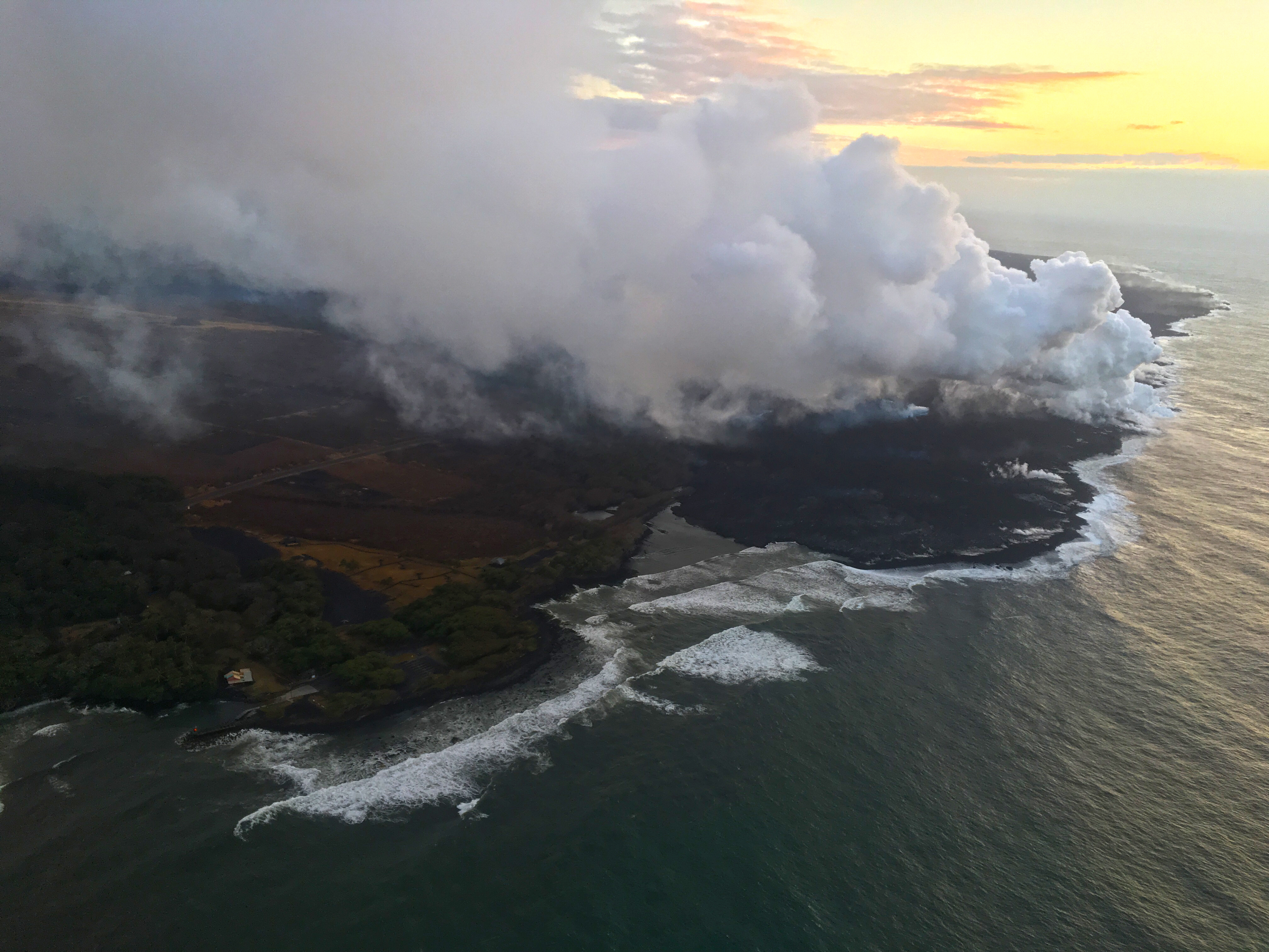
July 15, 2018. USGS: ” Laze plume rises where lava pours into the sea on the south margin of the fissure 8 flow. This southern boundary did not change location appreciably in the past day, remaining about 900 m (0.56 mi) from the boat ramp at Isaac Hale Park.” (Full-sized)
The tiny island that formed Friday is now a tiny peninsula, joined to shore by a neck of lava or possibly just black sand. Lava continues to ooze into the ocean here and there along the broad front of 6 km (3.7mi) lava delta. Recent HVO Kilauea status alerts have warned that this delta has built out 0.5 miles from the former coastline, and is resting on “unconsolidated lava fragments and sand,” which can give way.
Following this morning’s 3:26 am collapse event (M5.2) at Kilauea’s summit, a pulse of lava came down the rift zone to Fissure 8. This caused an early-morning, temporary overflow to the ESE which did not extend beyond the boundaries of earlier flows. (This spillover was very visible during a 6:30am @hotseathawaii livestream overflight). No other vents show any activity.
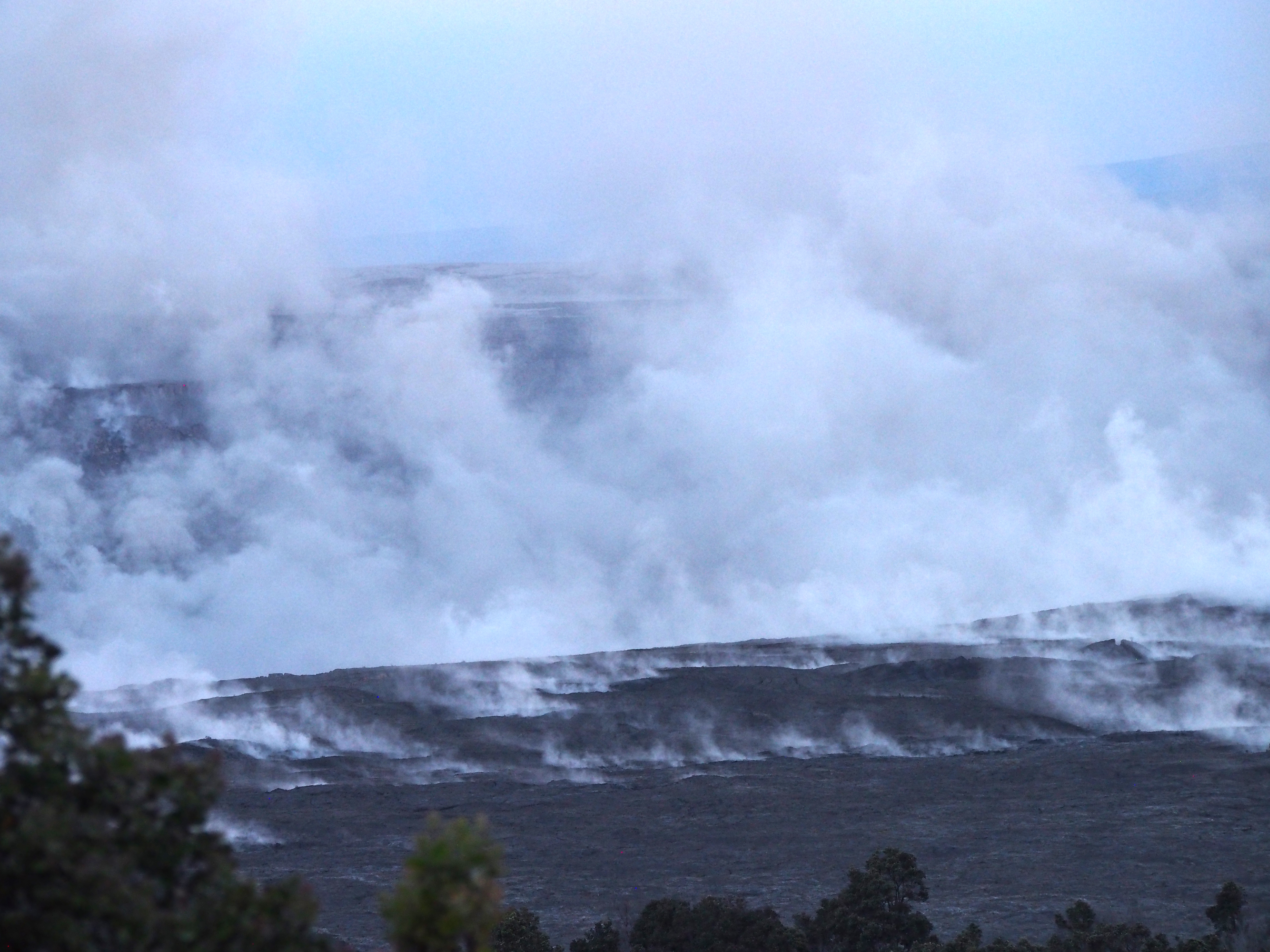
USGS: “View of Halema‘uma‘u taken today (July 15) from the south side of the caldera near the KEANAKEKOI Overlook.” (Full-sized)
July 14, 2018. USGS: ” Early morning view of fissure 8 and lava channel looking toward the east. Laze plume from the ocean entry is visible in distance (left of the fissure 8 plume). Geologists did not observe activity from any of the other fissures during this morning’s overflight.” (Full-sized)
Today’s Eruption Summary
The Lower East Rift Zone eruption has settled back into a routine. Unfortunately, that routine includes the far end of Fissure 8’s lava flow crawling south along the coast, eating landmarks in its path. Isaac Hale Park/Pohoiki boat ramp (see flow map) is next in line. The morning USGS overflight reported that the flow front was about 1km away.
Friday evening, July 13, 2018, 6:00 pm – Kilauea's east rift zone overflight: Lava continues to pour into the sea at…
Fissure 8 continues to erupt into its perched channel, with its volume surging after yesterday’s 7:08pm summit collapse (Mag 5.3) and returning to lower levels by morning. That pulse caused a brief overflow on the east/southeast of the channel a short way downstream from the vent, but it stayed on the apron of previous flows.
The channelized a’a flow west of Kapoho Crater continues to be the main conduit to the ocean and to the active flow expanding southwards along the shore. North of this, lava continues to “ooze out” at various points along the June-early July flow front, whose length now totals 6km (3.7 miles).
July 14, 2018. USGS: “White laze plumes mark locations where lava enters the ocean over a broad area. An open lava channel flows into the ocean at the southern-most plume (middle) near the southern flow margin. The boat ramp at Pohoiki is about 940 m (0.58 mi) farther south of the flow margin. View is toward the west-southwest.” (Full-sized)
While there’s no sign of activity at any fissures besides 8, the tiny island that popped up just offshore of Kapoho yesterday is still there for now.
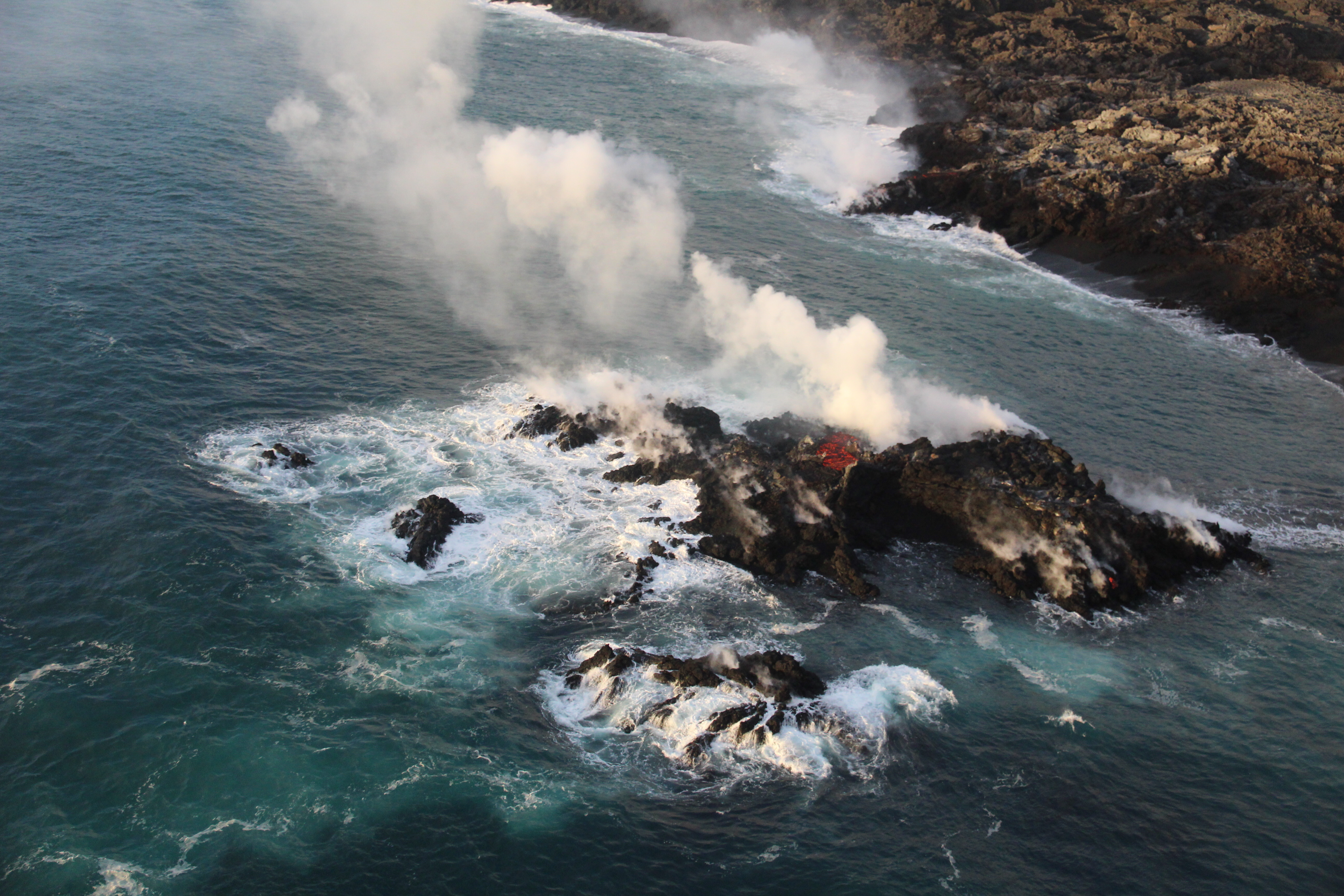
July 13, 2018. USGS: “A tiny new island of lava has formed on the northernmost part of the ocean entry. During this morning’s overflight, HVO’s field crew noticed the island was oozing lava similar to the lava oozing from the broad flow front along the coastline.” (Full-sized)
Today’s Eruption Summary
Fissure 8’s lava flow has settled into its new course, turning right just before Kapoho Cone and proceeding south-southeast to the ocean in a strong channelized a’a flow. Some lava, apparently following the earlier paths (lava tubes, maybe?) to the sea, is still squeezing out of the broad 6km (3.7) mile lava delta to the north of the new ocean entry.
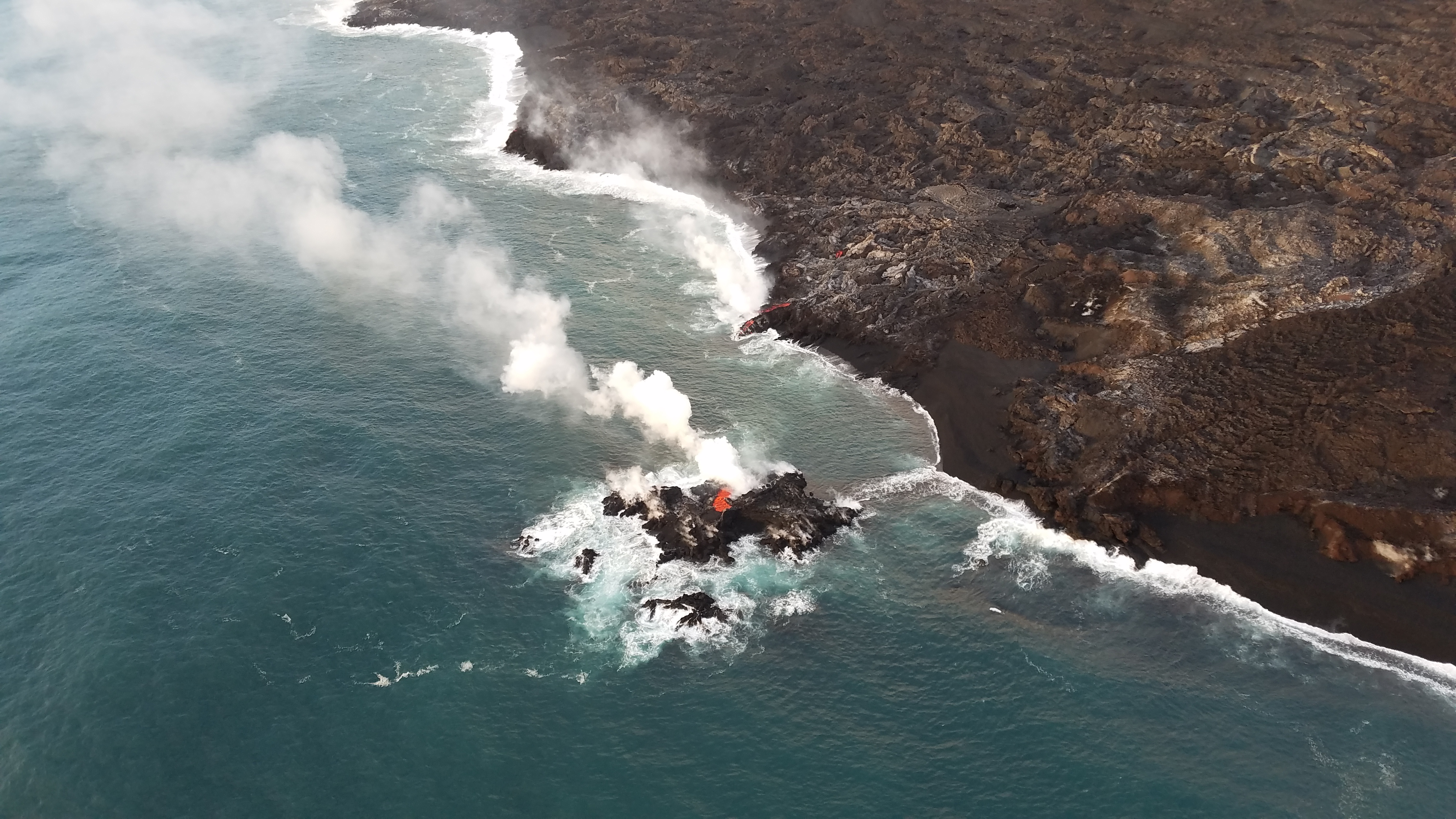
A fascinating footnote: while the northern “ooze-outs” are weakening, a tiny lava island popped up just offshore of them last night, and it is itself oozing lava:
July 13, 2018. USGS: “A closer view of the new “island,” which was estimated to be just a few meters offshore, and perhaps 6-9 meters (20-30 ft) in diameter. It’s most likely part of the fissure 8 flow that’s entering the ocean—and possibly a submarine tumulus that built up underwater and emerged above sea level.” (Full-sized)
Today’s summit collapse occurred at 7:06pm HST, with the energy equivalent of a 5.3 earthquake, as usual. HVO is setting up a new livestream from Volcano House, but it’s not fully operational yet, so we made do with the ailing HVO webcam today (video clip).
July 13, 2018. USGS: “View of Halema‘uma‘u and Kīlauea caldera just before 8:00 a.m. HST today, as seen from HVO’s observation point near Volcano House. Gusty winds were blowing quite a lot of rock-fall dust, visible both within and along the rim of the crater.” (Full-sized)
It’s been fascinating watching geologists collect data, figure things out, and incorporate these discoveries into their daily Kilauea alerts. Just as the HVO team started predicting the summit’s cyclical collapse/explosions, now they’ve started predicting (or at least watching for) Fissure 8’s lava surges and possible spillovers a few hours after each summit collapse. Sure enough:
Kīlauea Message Fri, 13 Jul 2018 21:53:34 HST: Following the 19:08 HST summit collapse explosion today there was an increase in activity from fissure 8 resulting in channel overflows on the south side of the flow near the vent.
Also, we’ve got a new view of ever-expanding Halema’uma’u Crater in Kilauea’s summit caldera this morning:
July 13, 2018. USGS: “USGS scientists captured this stunning aerial photo of Halema‘uma‘u and part of the Kīlauea caldera floor during a helicopter overflight of Kīlauea’s summit this morning. In the lower third of the image, you can see the buildings that housed the USGS Hawaiian Volcano Observatory and Hawai‘i Volcanoes National Park’s Jaggar Museum, the museum parking area, and a section of the Park’s Crater Rim Drive. Although recent summit explosions have produced little ash, the drab gray landscape is a result of multiple thin layers of ash that have blanketed the summit area during the ongoing explosions.” (Full-sized)
I couldn’t find a comparable aerial photo with the observatory and Jaggar in shot, but this 2009 photo of Halema’uma’u is facing in approximately the same direction. (Look for Crater Rim Rd behind the crater on the left, and note the parking lot obscured by the lava lake’s plume in 2009— lava lake, parking lot, and part of that road collapsed into the crater in June.)
July 11, 2018. USGS: “A pāhoehoe flow fed by overflows from the fissure 8 lava channel was active along Nohea Street in the Leilani Estates subdivision this morning.” (Full-sized)
Today’s Eruption Summary
Quite a lot happened today in the LERZ. Fissure 8 started overflowing again about 8:30-9am this morning. Unfortunately, some spillouts on the north side extended past the edges of previous flows, destroying three more homes in Leilani Estates, two on Luana St, one on Nohea.
Another blockage just west of Kapoho Crater last night diverted much of the main lava channel around the west side of the crater’s cone, rejoining the main flow field on the other side. It created a channelized a’a flow which skirted the southern edge of the existing lava field, and was a quarter mile from the coast and Ahalanui Warm Pond by noon. [Update 10pm HST: I’m seeing several unconfirmed reports on social media that it and Kua O Ka La Charter School were taken by lava late Wednesday afternoon or early evening.]
However, some lava is still being supplied to earlier ocean entry areas, either by still-molten lava that’s permeated the lava delta, or by a lesser supply of new lava following the old route around Kapoho Crater. This lava is working on building a point (it’s still not the easternmost point of the island, although the angle of the left-hand photo makes it appear so):
New lava channel on south side of existing channel and wraps around west side of Kapoho cone, lava within 2,000 ft of the coast at Ahalanui Beach Park. Summit collapse event occurred at 5:46 AM HST.https://t.co/7sDZqcOJ5spic.twitter.com/kkt3wI7XAy
Interestingly, today’s tardy summit collapse at 5:46am (M5.3 as usual) seems to have had some effect upon Fissure 8. There’s been speculation that might be occurring, but it wasn’t confirmed until now. According to the HVO update: “The collapse/explosive event this morning was followed by an increase in lava from the fissure 8 vent which has produced small overflows from the upper channel that are threatening a few homes on Nohea and Luana streets.”
July 11, 2018. USGS— in fact this is another Don Swanson photo, according to the FB caption: “A telephoto view of the eastern edge of Halema‘uma‘u taken just two minutes after today’s (July 11) 5:45 a.m. HST collapse explosion event. Steam is intermixed with minor ash that imparts a pinkish-brown color to the plume. The energy released by the event was equivalent to a magnitude-5.3 earthquake.” (Full-sized)
Fissure 22 continues to sputter quietly and intermittently, so the sluggish flow it was emitting a week or so ago has cooled.
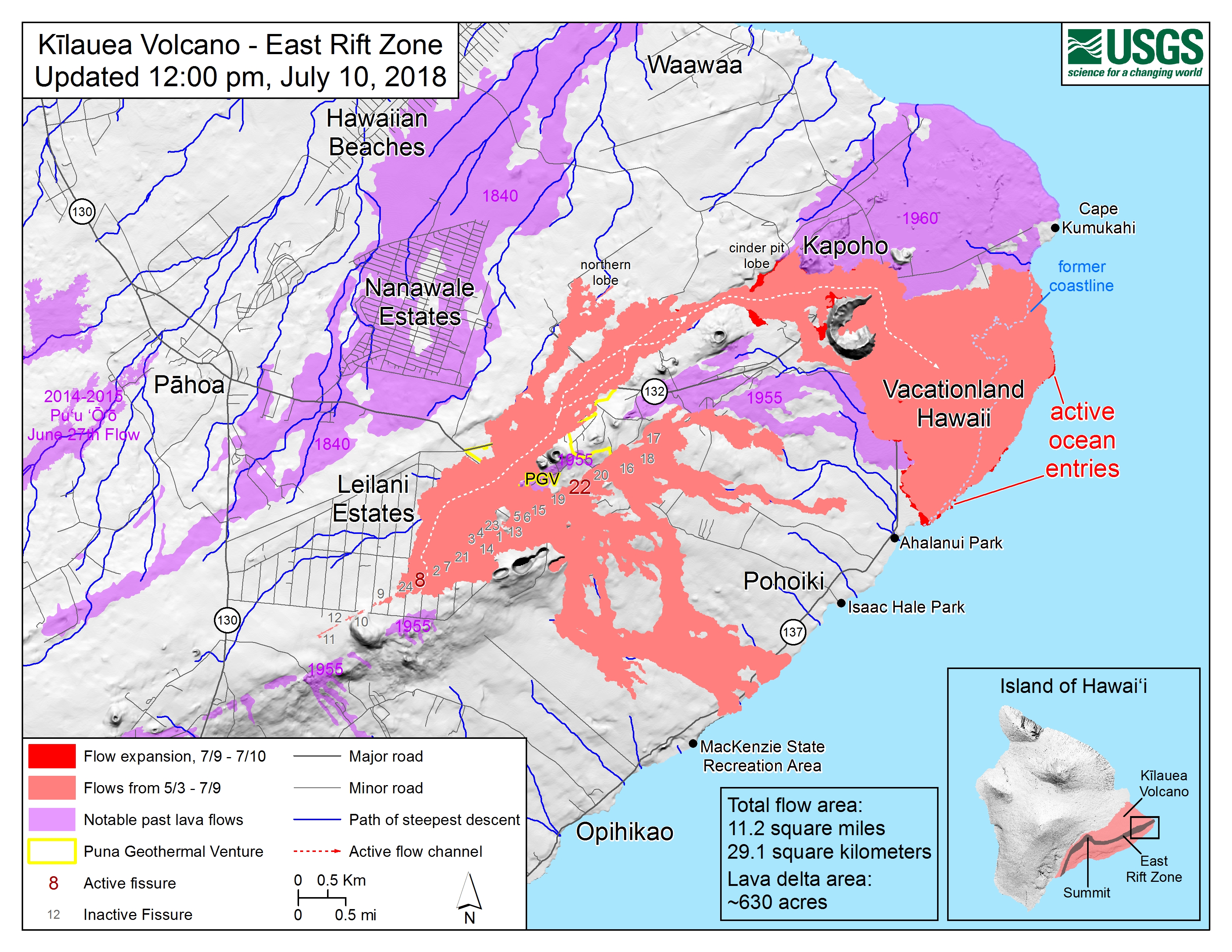
Transcript of Steve Brantley’s Tuesday evening presentation at the weekly community meeting, July 10, 2018.
Steve Brantley (HVO/USGS): Well, good evening. Thank you for turning out. I worked really hard this afternoon to prepare my very best presentation for you tonight, and lo and behold, somehow it didn’t end up on my jump drive. So for that, I apologize. And what I’ll do is basically recount the presentation, but you’ll have to— we can refer to the map up here.
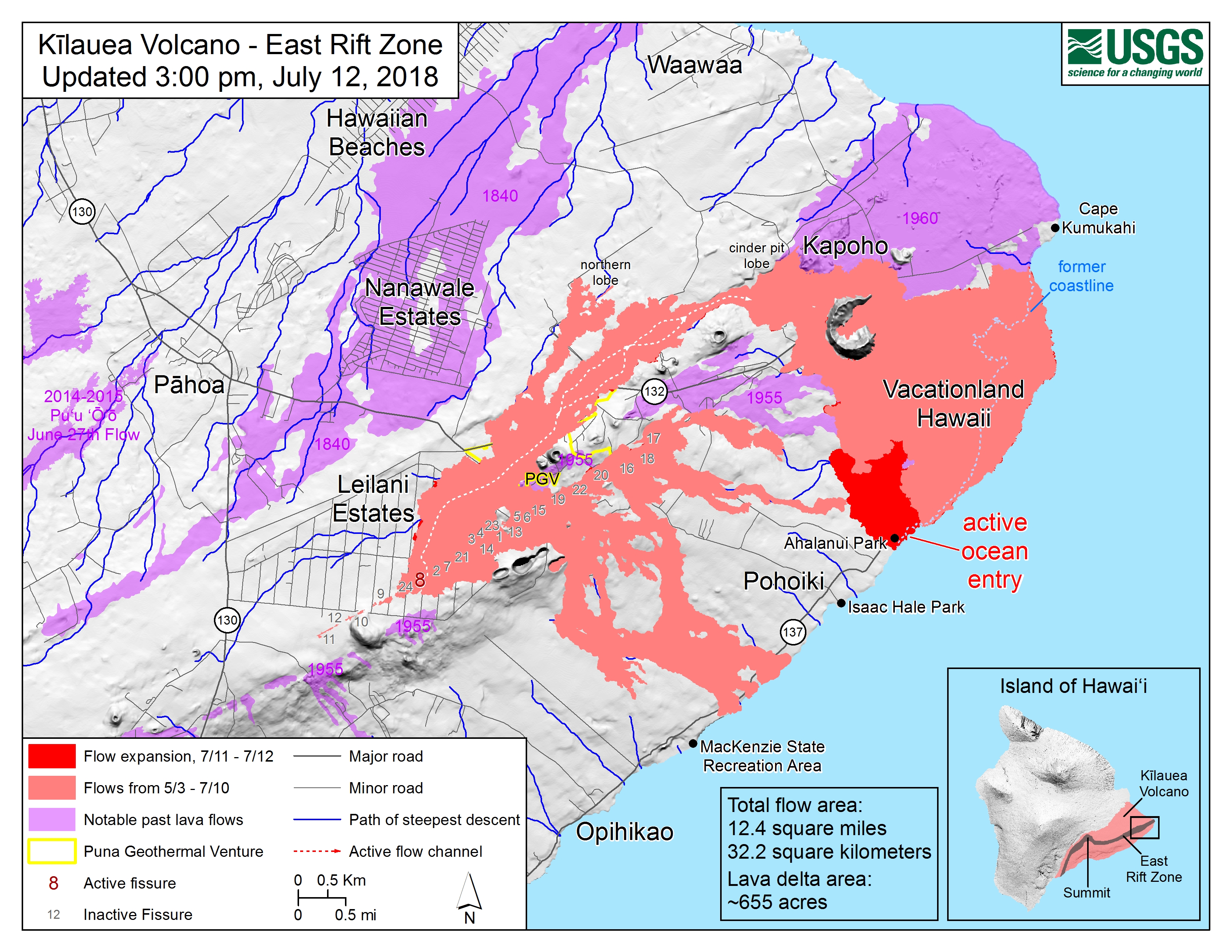
July 10, 2018, noon USGS map of lava flows. (Full-sized)
So the overall picture is that the activity at Fissure 8 has not fundamentally changed. A high rate of lava is still being erupted, and we really haven’t noticed a change in that rate. At the summit, the volcano continues to subside very slowly over time, and periodically— now about once every 30 hours, or almost every day— the ground drops as much as two and a half meters or so in each drop, and results in a ground shaking that’s equivalent to about a magnitude 5 event.


