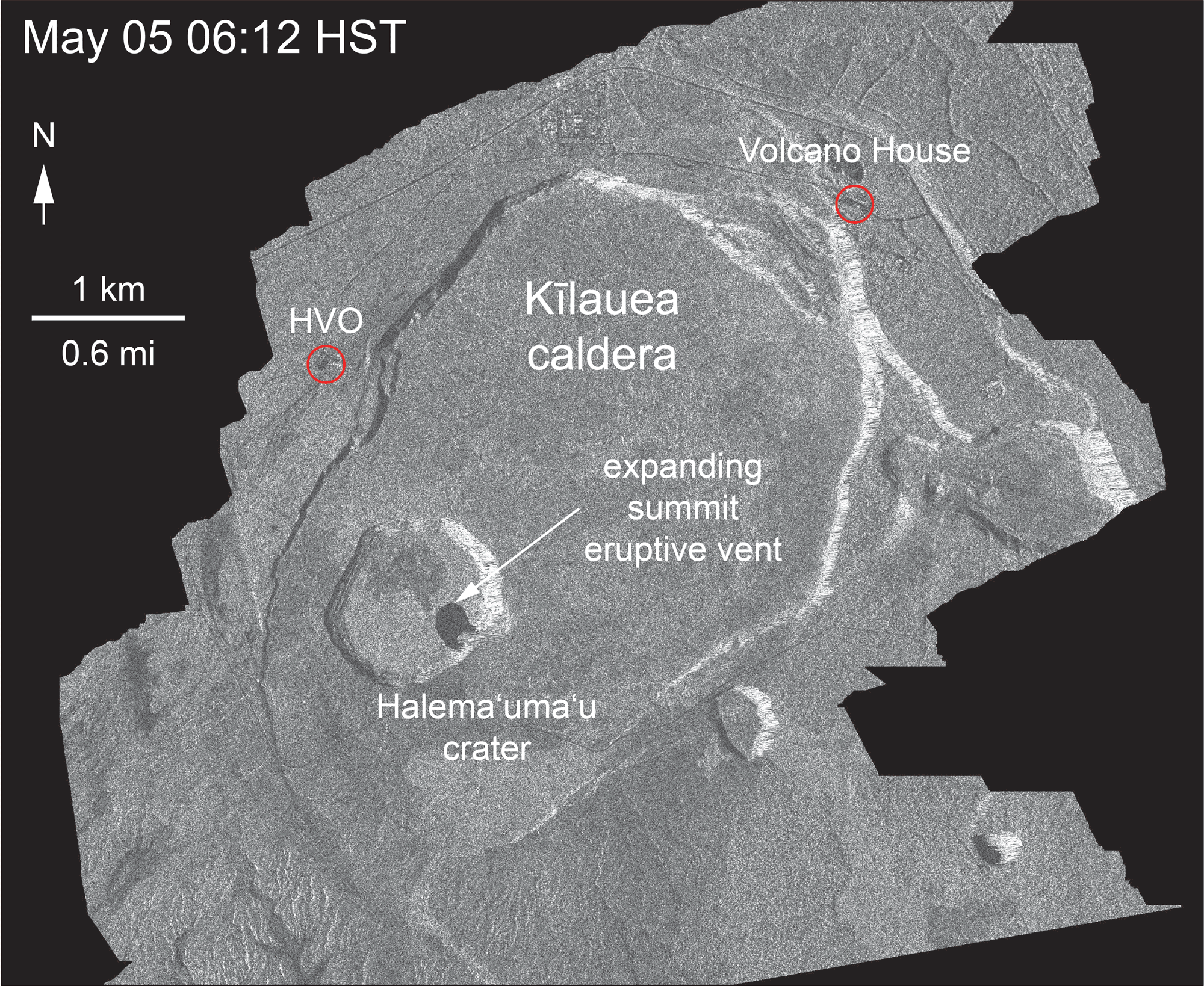
Thanks to the Italian Space Agency for taking a radar satellite image of Kilauea about once a week:
USGS: “May 5 and June 18 at about 6:00 a.m.[…]The last five images in the sequence, from May 29-June 18, show the development of several cracks outside Halema‘uma‘u (also seen in recent UAS footage of the crater) and inward slumping of a large portion of the western, southwestern, and northern crater rim. Much of this motion appears to be coincident with the small explosions from the summit that have taken place on a near daily basis over the past 3 weeks.” (Full-sized)Yes, HVO and the Jaggar Museum have evacuated, and artwork has been moved to safety.
Here’s a map to orient you. HVO is the Hawaii Volcano Observatory, right next to Jaggar Museum.
Kilauea on Google Maps still has the pre-May-eruption data for now. I’ve added “Jaggar Museum” and old Halema’uma’u parking lot in yellow. (Full-sized)
It’s a crater-within-a-crater-within-a-crater: The lava lake that formed in 2008 (steaming in above image), inside Halema’uma’u Crater (almost circular), within the larger, oval-shaped Kilauea Caldera. The draining of the lava lake and the magma beneath caused Halema’uma’u to collapse into the hole it left.
August 1995 (Jeff Kubina)
August 1995: Halema’uma’u Crater before the 2008 lava lake. Taken by Jeff Kubina, Creative Commons. I think this was taken from the old Halema’uma’u Overlook trail just to the right of the parking lot along the crater rim, which has now fallen in. (Link to full-sized)
Overlook vent lava lake 2008-2017 (USGS)
Here’s a good USGS video on the lava lake’s ~10-year history, showing how it started and grew.
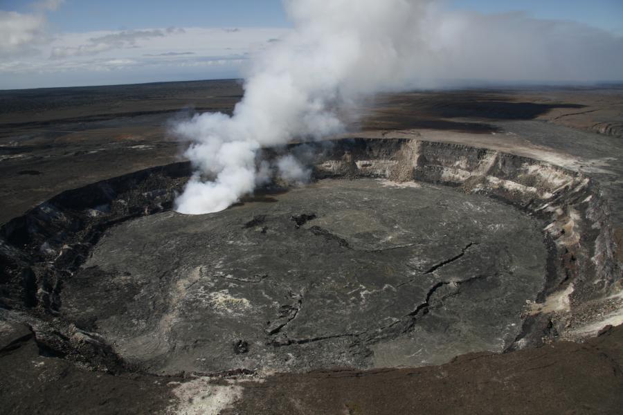
May 14, 2010 (USGS)
USGS: “View of Halema’uma’u Crater to the Overlook vent at the summit of Kilauea Volcano… typical tradewind conditions, which blows the gas plume to the southeast. For scale, the Halema’uma’u Crater is about 1km (0.6 mi) across (left to right); the floor… is about 80m (260 ft) below the crater rim.” (Full-sized)
March 3, 2011 (USGS) – Rockfall, ash plume
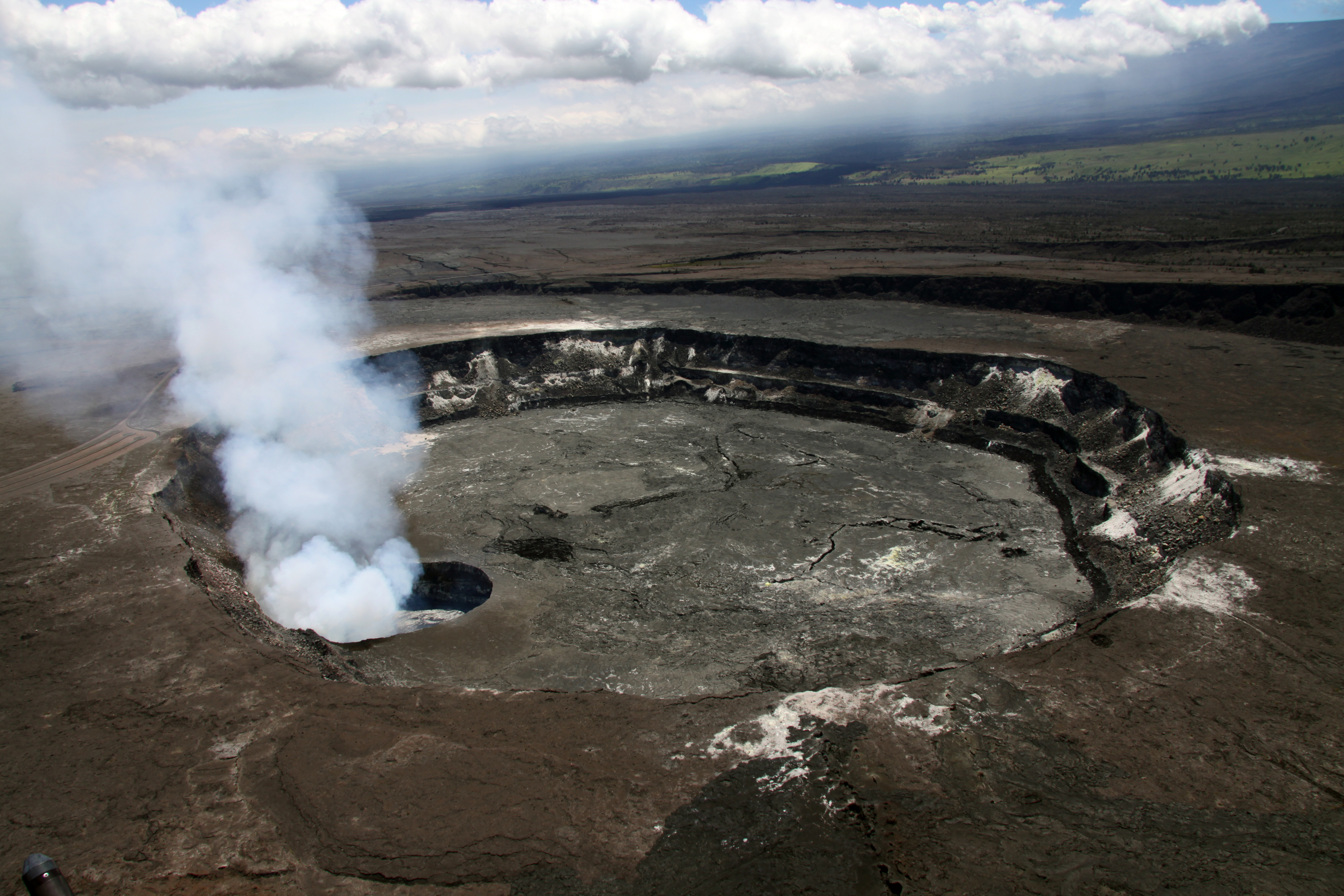
May 5, 2015 (USGS)
May 5, 2015, USGS: “Over the past week, the summit lava lake spilled out onto the floor of Halema‘uma‘u Crater, creating the dark flows in the south part of Halema‘uma‘u (left side of crater from this direction). The overflows, not counting the area of the lake itself, total about 11 hectares (28 acres).” (Full-sized)May 5, 2015, USGS: “A closer look at the lava lake and overflows on the floor of Halema‘uma‘u Crater. The outline of the Overlook crater, and the active lake, is easier to distinguish in this view.” (Full-sized)May 5, 2015, USGS:”From this angle, the extent of the lava lake within the Overlook crater is much easier to distinguish from the surrounding overflows. The closed Halema‘uma‘u parking lot is in the right side of the photograph.” (Full-sized)
June 9, 2015 (USGS)
June 9, 2015. USGS: “One month ago the summit lava lake was at the rim of the Overlook crater (the small crater in the center of the photo), spilling lava onto the floor of Halema‘uma‘u Crater (the larger crater that fills much of the photo), creating the dark flows surrounding the Overlook crater. Since that time the lava lake has dropped, associated with summit deflation, and today the lake level was about 60 meters (200 feet) below the Overlook crater rim. The stack of recent overflows is visible on the wall of the Overlook crater as the layer of dark lava atop the older, light colored lava forming the majority of the Overlook crater wall. The photo is taken from the southeast rim of Halema‘uma‘u Crater. The closed Halema‘uma‘u overlook is in the upper left corner of the photo. Jaggar Museum and HVO can be seen as a small bump on the horizon in the upper right portion of the photograph.” (Full-sized)
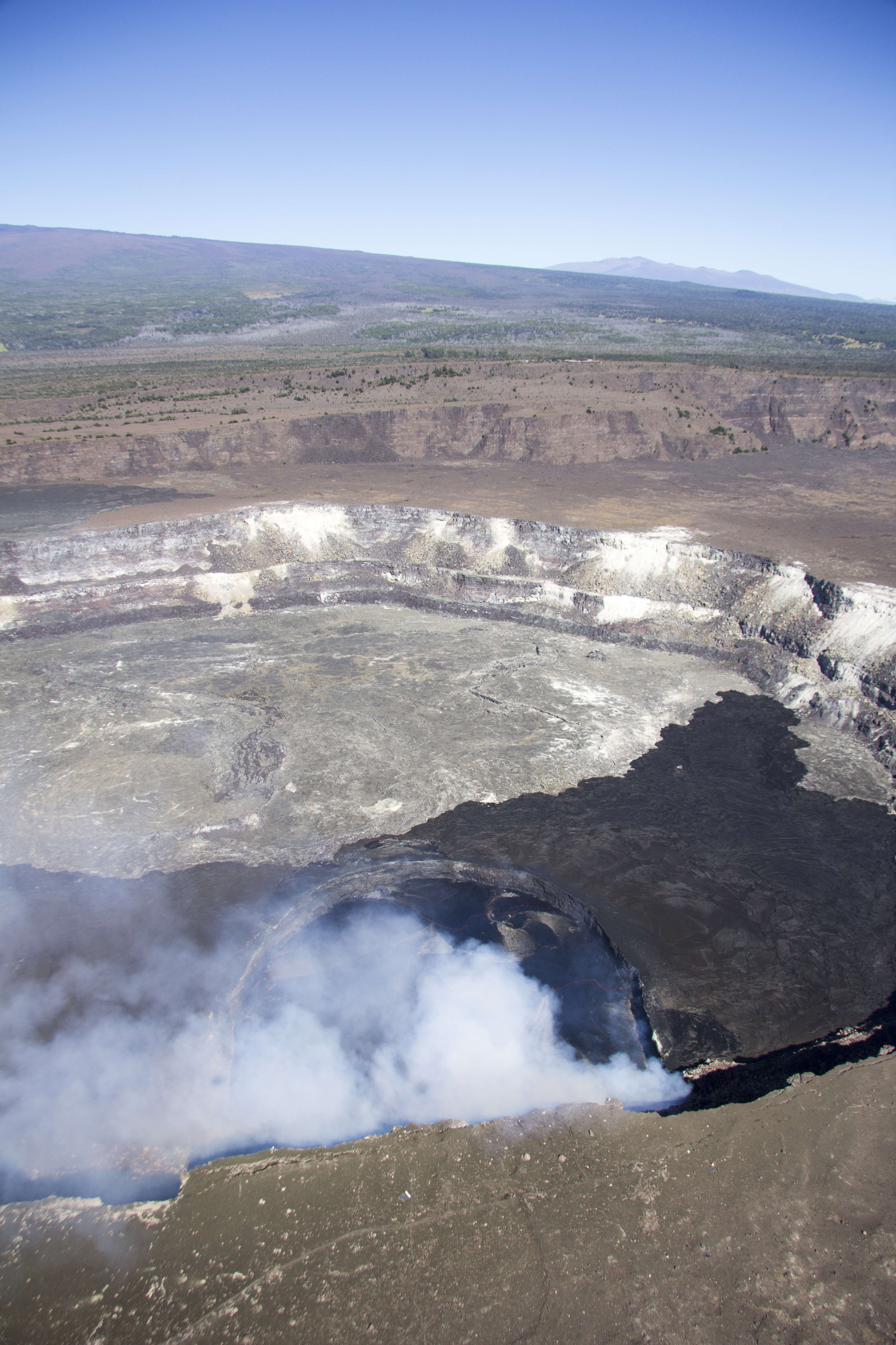
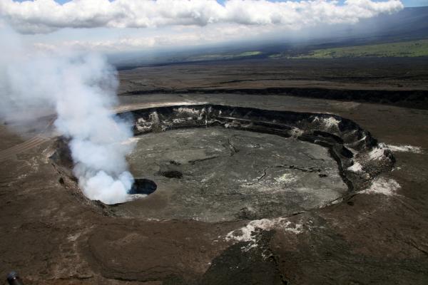
November 3, 2016 (USGS)
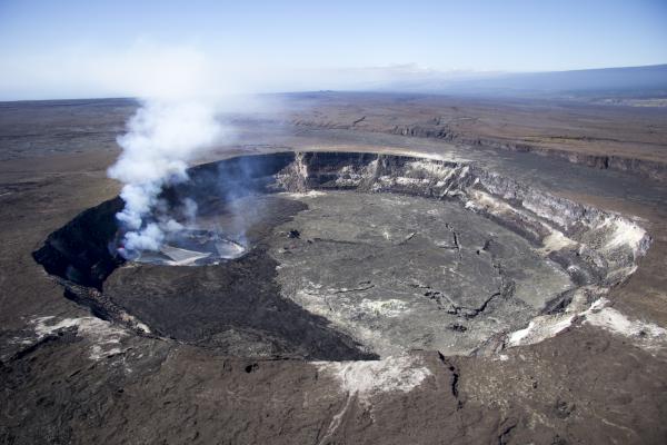
USGS:“Halema‘uma‘u Crater, shown here, is about a kilometer (0.6 miles) across and contains a lava lake in a smaller crater, informally called the Overlook crater, at its southeast edge. The lava lake is about 250 m (~820 ft) long and 180 m (~590 ft) wide and, when this photo was taken, the surface of the lake was about 15 m (~50 ft) below the Overlook crater rim. The view is to the southwest, looking out into the Ka‘ū Desert in the distance. The western slope of Mauna Loa forms the skyline to the right.” (Full-sized)USGS: “This view shows Kīlauea’s summit lava [lake] from the south, with the east slope of Mauna Loa in the background and Mauna Kea in the distance. [HVO and] Jaggar Museum buildings are visible on the rim of Kīlauea’s summit caldera, behind Halema‘uma‘u. The dark lava flow on the floor of Halema‘uma‘u was mostly erupted during April–May 2015.” (Full-sized)
august 8, 2017 (Guy Courtemanche)
August 8, 2017: Halema’uma’u Crater with its lava lake steaming away. Note: I’ve cropped sides. By Guy Courtemanche, Creative Commons. Link to original photo’s page.August 8, 2017: Halema’uma’u at sunset. The lava lake was gorgeous at night. Looks like ash explosion triggered by a rockfall? By Guy Courtemanche, Creative Commons. Link to full-sized
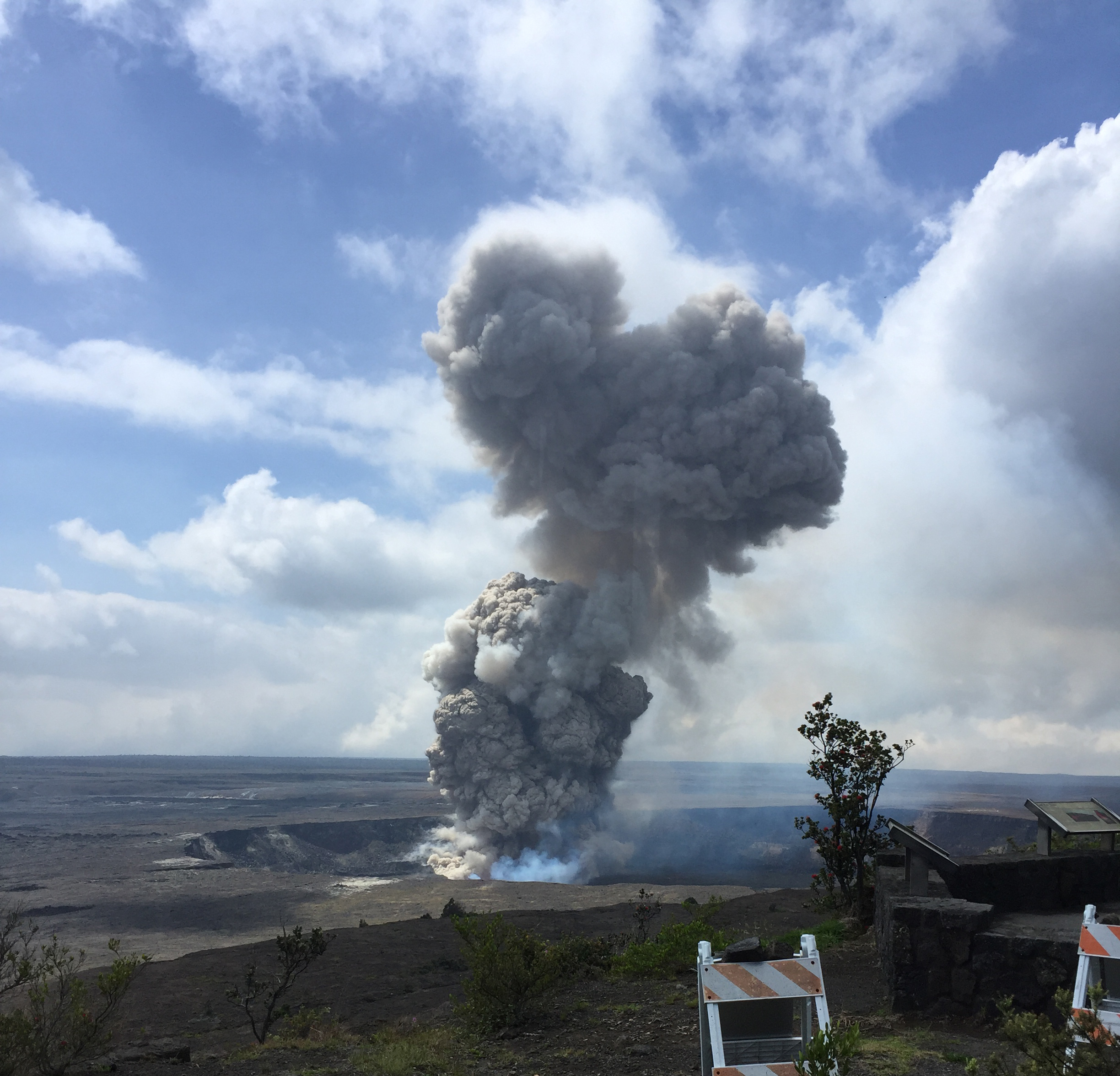
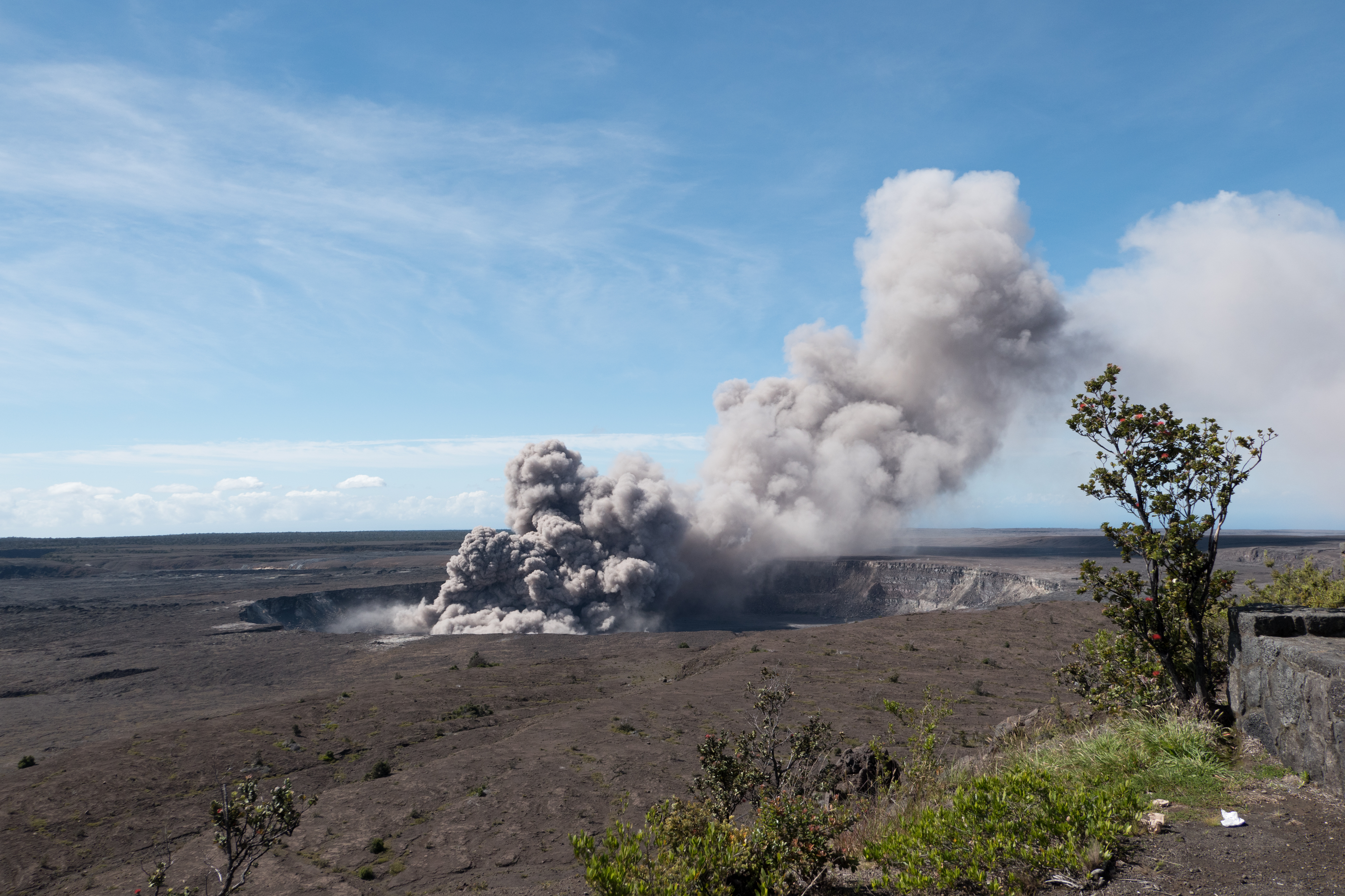
April 6, 2018 (USGS) ash plume
USGS: “Today at 10:28 a.m. HST, a partial collapse of the southern Overlook crater wall triggered an explosive event at Kīlauea Volcano’s summit lava lake. A large plume of gas, ash, and lava fragments was seen rising from the lava lake at the Jaggar overlook. The explosion threw debris onto the Halema‘uma‘u crater rim at the old visitor overlook, which has been closed due to ongoing volcanic hazards such as this explosive event.” (Full-sized)
April 2018 (USGS)
Just before everything changed.
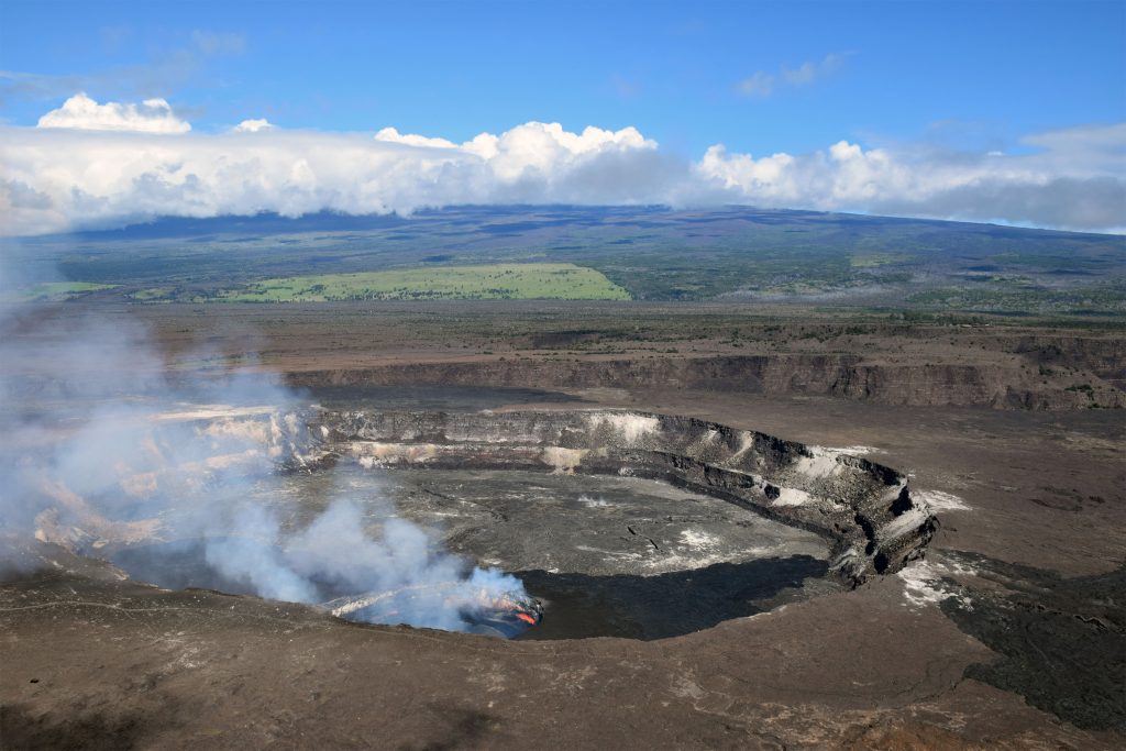
April 13, 2018. USGS Caption: “At the summit of Kīlauea Volcano, the gas plume produced by the Halema‘uma‘u lava lake was blown to the southwest by normal trade wind conditions today. The lake level has been relatively high over the past several weeks and intermittently visible from the Hawai‘i Volcanoes National Park Jaggar Museum Overlook. The museum and HVO are perched on the caldera rim (middle right), with the slopes of Mauna Loa visible in the background.” (Full-sized)April 22, 2018. USGS: “A helicopter overflight this afternoon (April 23) of Kīlauea Volcano’s Halema‘uma‘u crater showed the extent of the largest overflow (silver gray) of the lava lake, which occurred from approximately 6:30 a.m. to 9:30 a.m. this morning. The overflow covered much of the April/May 2015 and October 2016 overflows, but a section of the 2015 overflow is still visible on the south (upper edge) of the Halema‘uma‘u crater floor. [..]Multiple spattering sites were active around the margin of the summit lava lake, and the lake surface had dropped to a few meters (yards) below the vent rim. The lower lake level reflected the switch from inflation to deflation at the summit of Kīlauea.” (Full-sized)
April 25, 2018 (USGS) timelapse
Skip to about 0:30 for daytime view. From Halema’uma’u overlook looking north.
USGS: “At approximately 6:15 a.m. today (April 26) a new overflow began on Halema‘uma‘u crater floor. The lava lake overflow continued until about 10:30 a.m. and covered about 36 hectares (90 acres) of the crater floor with lava (approximately 2/3). This is the largest overflow since the summit eruption began in 2008. This photo is looking south, and the gas plume is being produced by the lava lake in the southeast crater floor (upper left).” (Full-sized)
USGS:“As of this afternoon (May 1), the eruption at the summit of Kīlauea has apparently not been affected by the collapse at Pu‘u ‘Ō‘ō or intrusion of magma along the volcano’s Lower East Rift Zone. Following multiple overflows of the summit lava lake on April 21-27, which spilled lava onto the floor of Halema‘uma‘u, the lava lake level dropped over the weekend (April 28-29). But on the morning of April 30, the lava lake level began to rise in concert with summit inflation. This image of the summit lava lake was taken during HVO’s overflight just before 8:00 a.m. today.” (Full-sized)
The summit began dropping May 2. By May 6, the lava lake had dropped 220 meters from the crater rim, but Halema’uma’u was not yet affected.
May 7, 2018 (USGS)
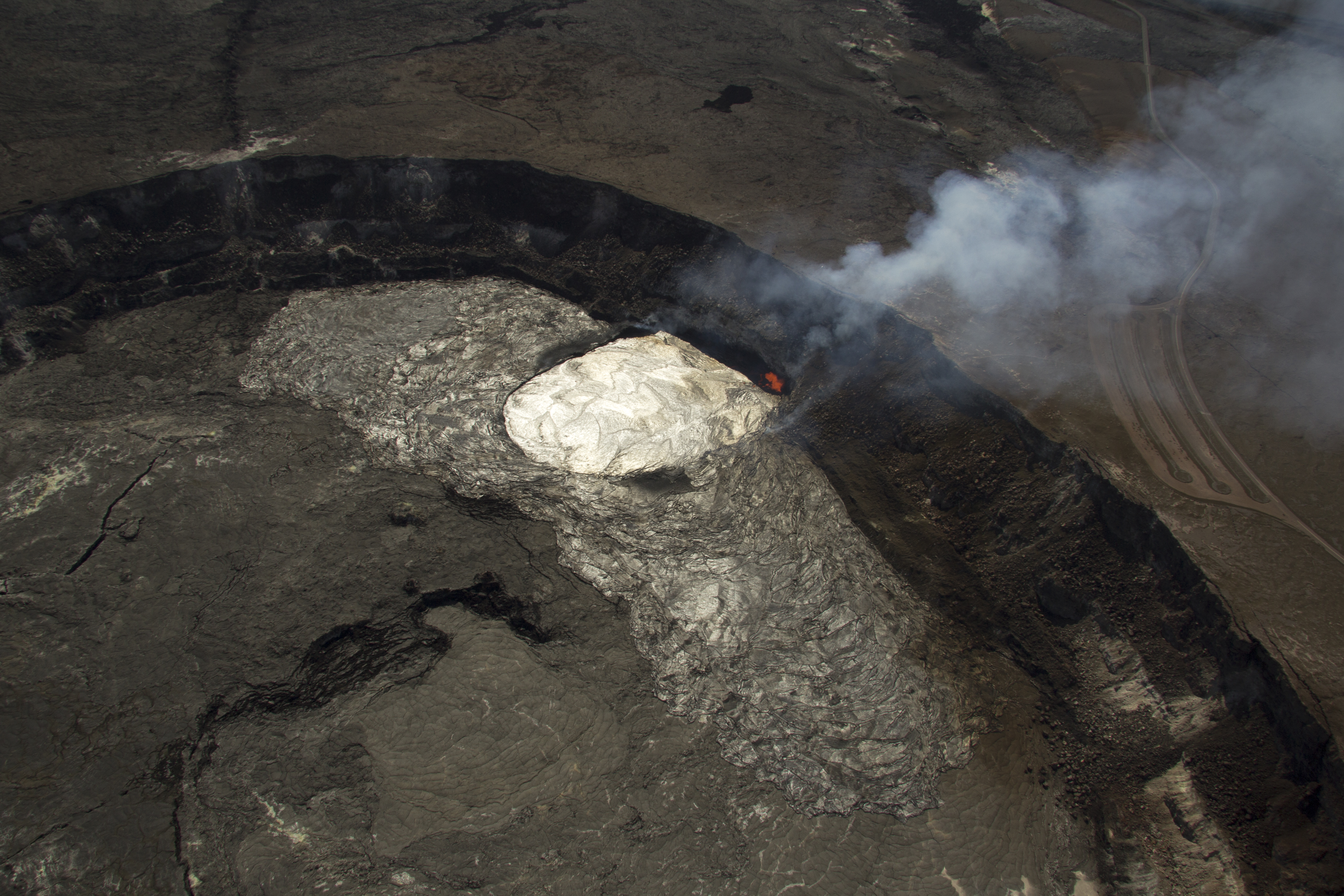
May 9, 2018 (USGS)
By May 8, the lava lake was 970 feet below the floor of Halema’uma’u Crater, but still above the water table. Just. USGS mapped a 3D model of the lava lake on May 8, but it didn’t include all of Halema’uma’u Crater.
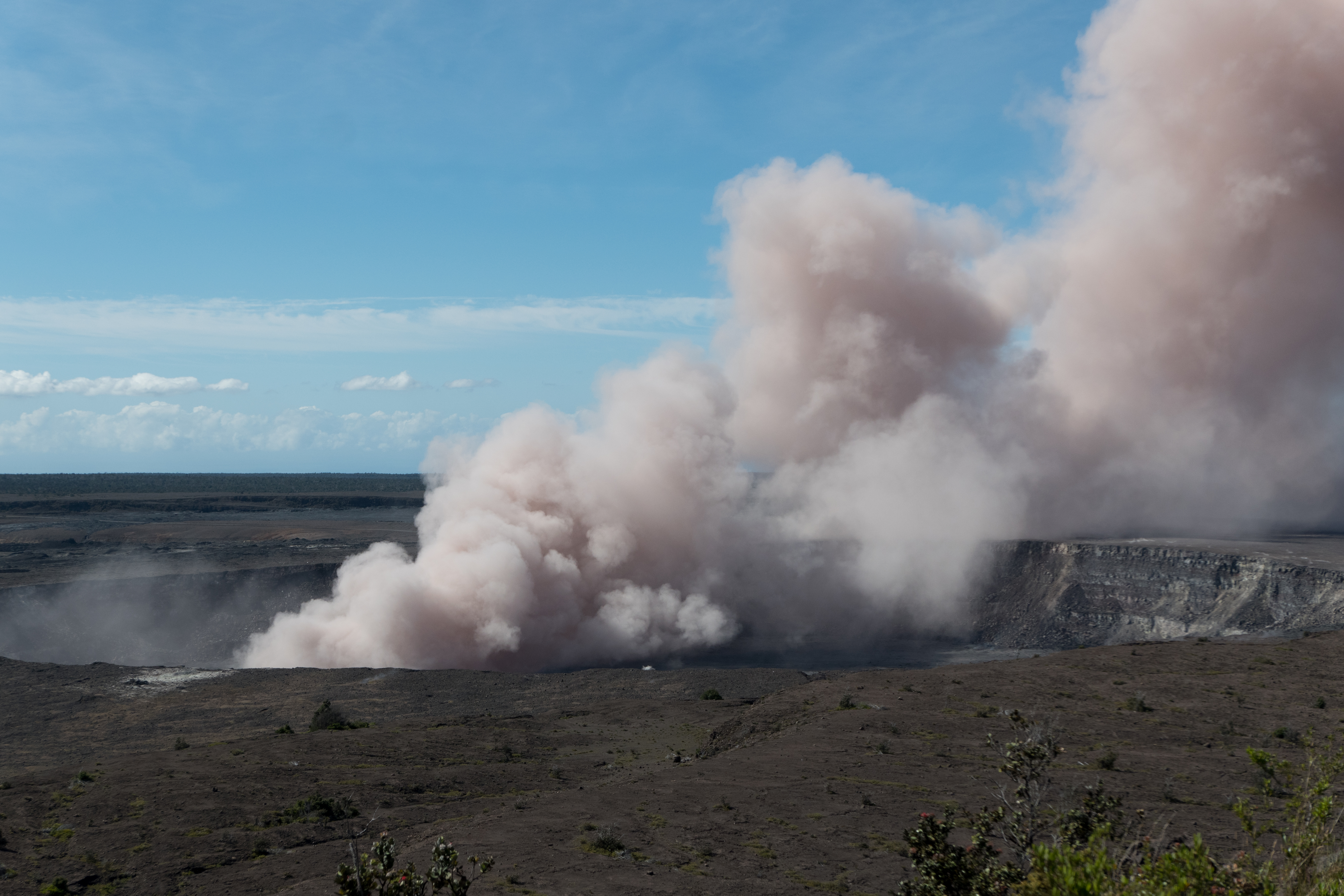
USGS: “Ash column rises from the Overlook crater at the summit of Kīlauea Volcano. HVO’s interpretation is that the explosion was triggered by a rockfall from the steep walls of Overlook crater. The photograph was taken at 8:29 a.m. HST from the Jaggar Museum overlook. The explosion was short-lived. Geologists examining the ash deposits on the rim of Halema‘uma‘u crater found fresh lava fragments hurled from the lava lake. This explosion was not caused by the interaction of the lava lake with the water table. When the ash cleared from the crater about an hour after the explosion, geologists were able to observe the lava lake surface, which is still above the water table.”(Full-sized)
USGS: “At 9:06 a.m. HST, an ash plume rose from the Overlook crater at Kīlauea’s summit. Similar to recent plumes, this event was likely caused by a rockfall from the crater’s steep walls. The plume’s reddish color is most likely from altered rock and ash fragments that fell into the deepening conduit.” Full-sized or wide-angle of 9:17 explosion. Again, from HVO/Jaggar Museum overlook.
May 17 was the 30,000 foot high eruption (the largest).
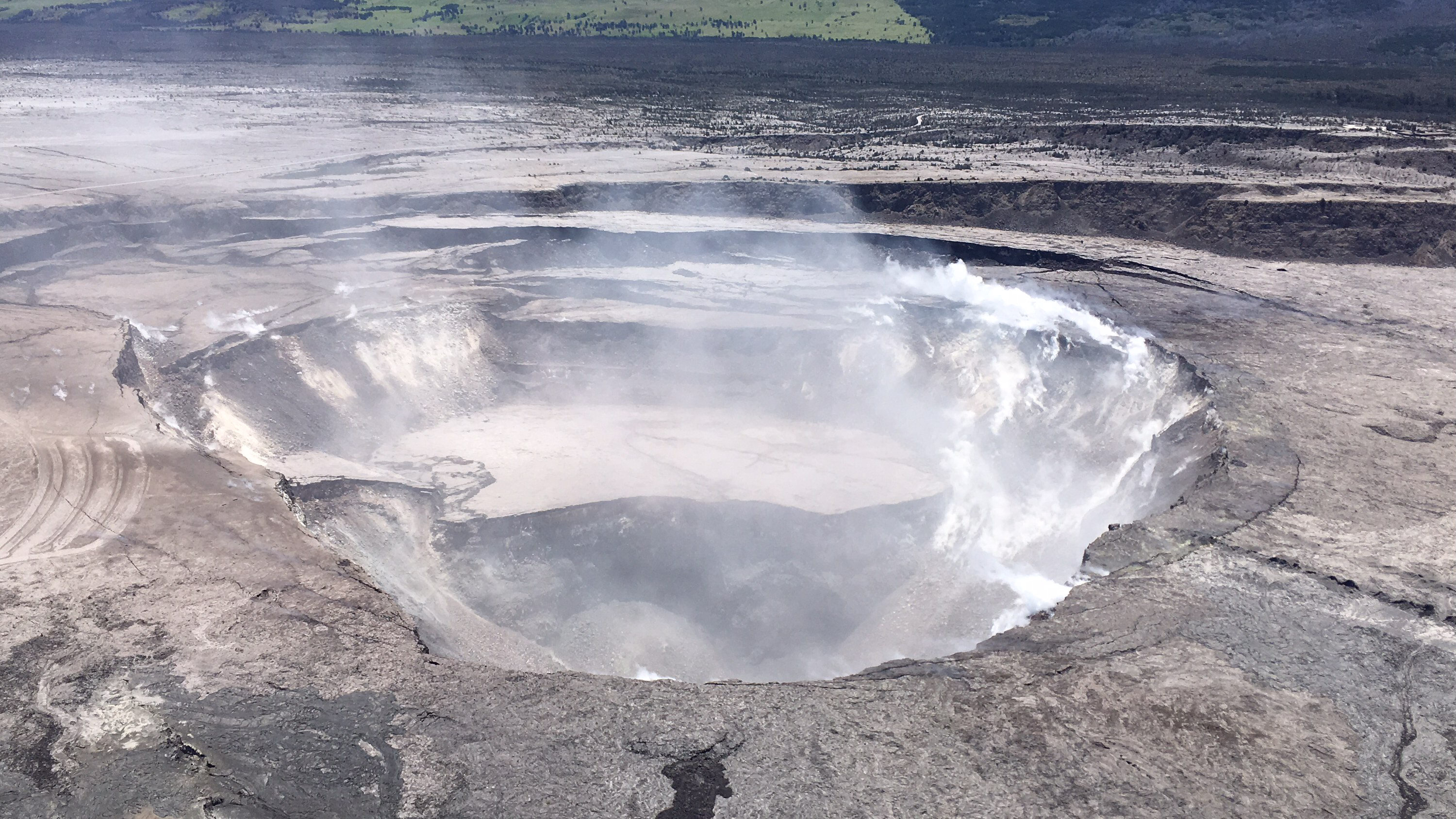
USGS: “A small explosion occurred at 12:55 a.m. HST on May 20 in Halema‘uma‘u, a crater at the summit of Kīlauea Volcano. It produced an ash plume that reached about 7,000 feet above sea level and was carried by the wind to the southwest. […]The photo was taken during a UAV (unmanned aerial vehicle) survey of Halema‘uma‘u on the morning of Sunday, May 20. The crater wall is just visible through the steam plume, showing scars from rockfalls that have been enlarging the crater over the past few days.” (Full-sized)
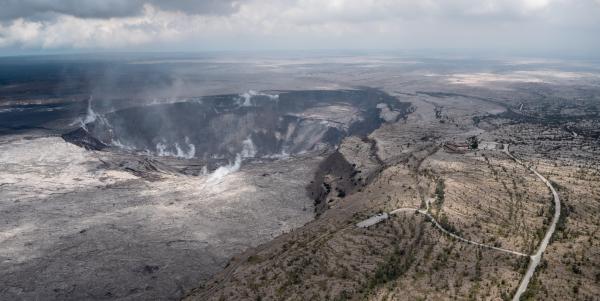
It’s hard to find aerials of Kilauea Caldera (the larger crater that contains Halema’uma’u Crater) – here’s one. Note HVO/Jagger Museum on caldera rim and dark lava flow radiating away from rim of Halema’uma’u across caldera floor. See also April 23 overflight – Small, Large – although that’s closer and turned 90° counterclockwise.
USGS: Aerial view of Kīlauea Volcano’s summit caldera and an ash plume billowing from Halema‘uma‘u, a crater within the caldera. The USGS–Hawaiian Volcano Observatory and Hawai‘i Volcanoes National Park’s Jaggar Museum are visible on the caldera rim (center right); Kīlauea Military Camp can be seen in the lower right. Photo courtesy of the Civil Air Patrol. (Full-sized photo)
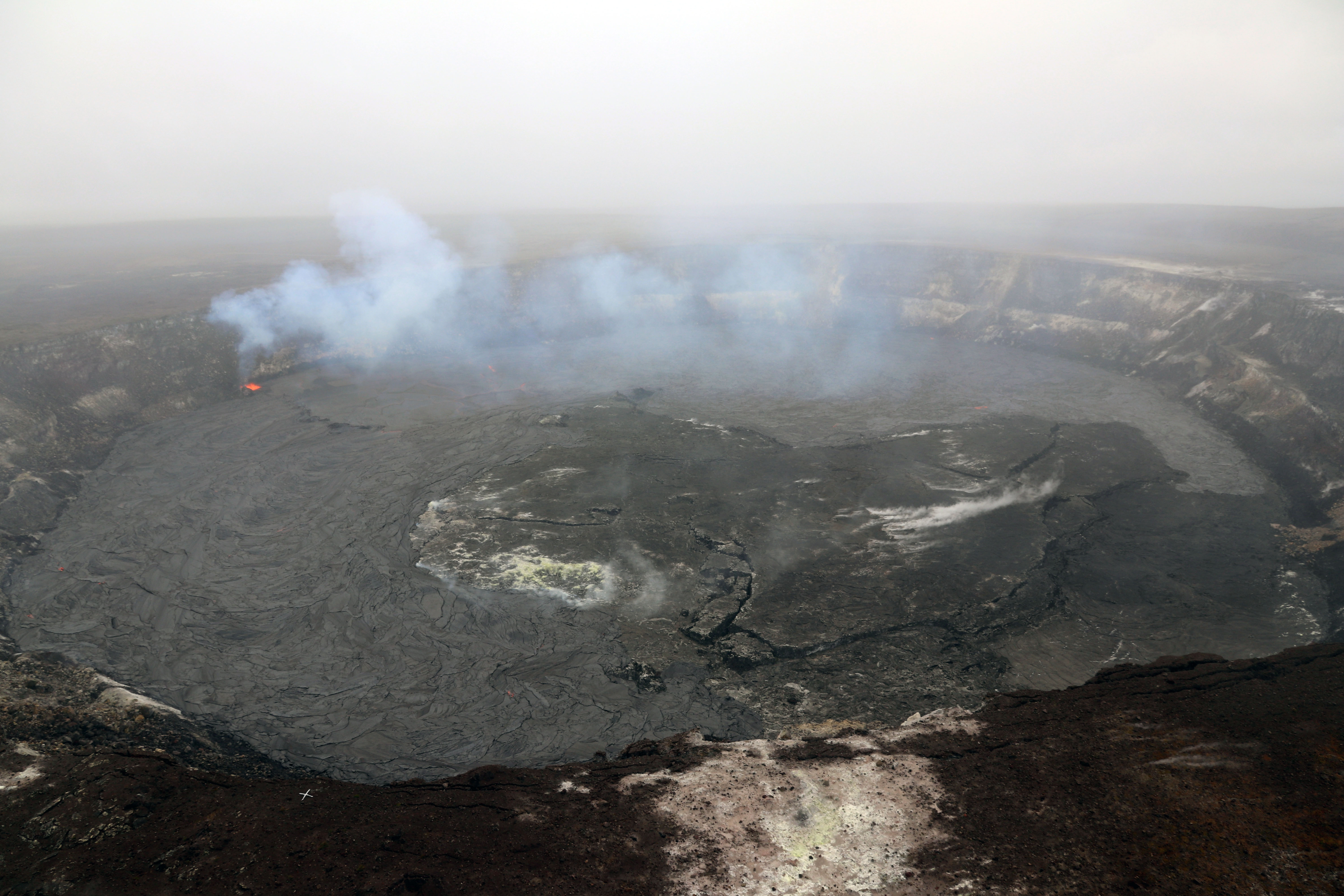
May 26-30 seems to be when Halema’uma’u really began to subside/slump; numerous large ash explosions.
May 31, 2018 (USGS)
That’s about when it settled into the current pattern of earthquakes building up to a 5.3 explosion about once a day.
USGS Caption: “HVO scientists captured this aerial view of a much-changed Halema‘uma‘u during their overflight of the summit this afternoon. Explosions and collapse within Halema‘uma‘u have enlarged the crater (foreground) that previously hosted the summit lava lake, and the far rim of Halema‘uma‘u has dropped with continued summit deflation. The parking area for the former Halema‘uma‘u Overlook (closed since early 2008 due to volcanic hazards) can be seen to the left of the crater.” (Full-sized)
June 13, 2018 Drone Footage (USGS)
Keep in mind the area of deepest collapse was formerly the lava lake.
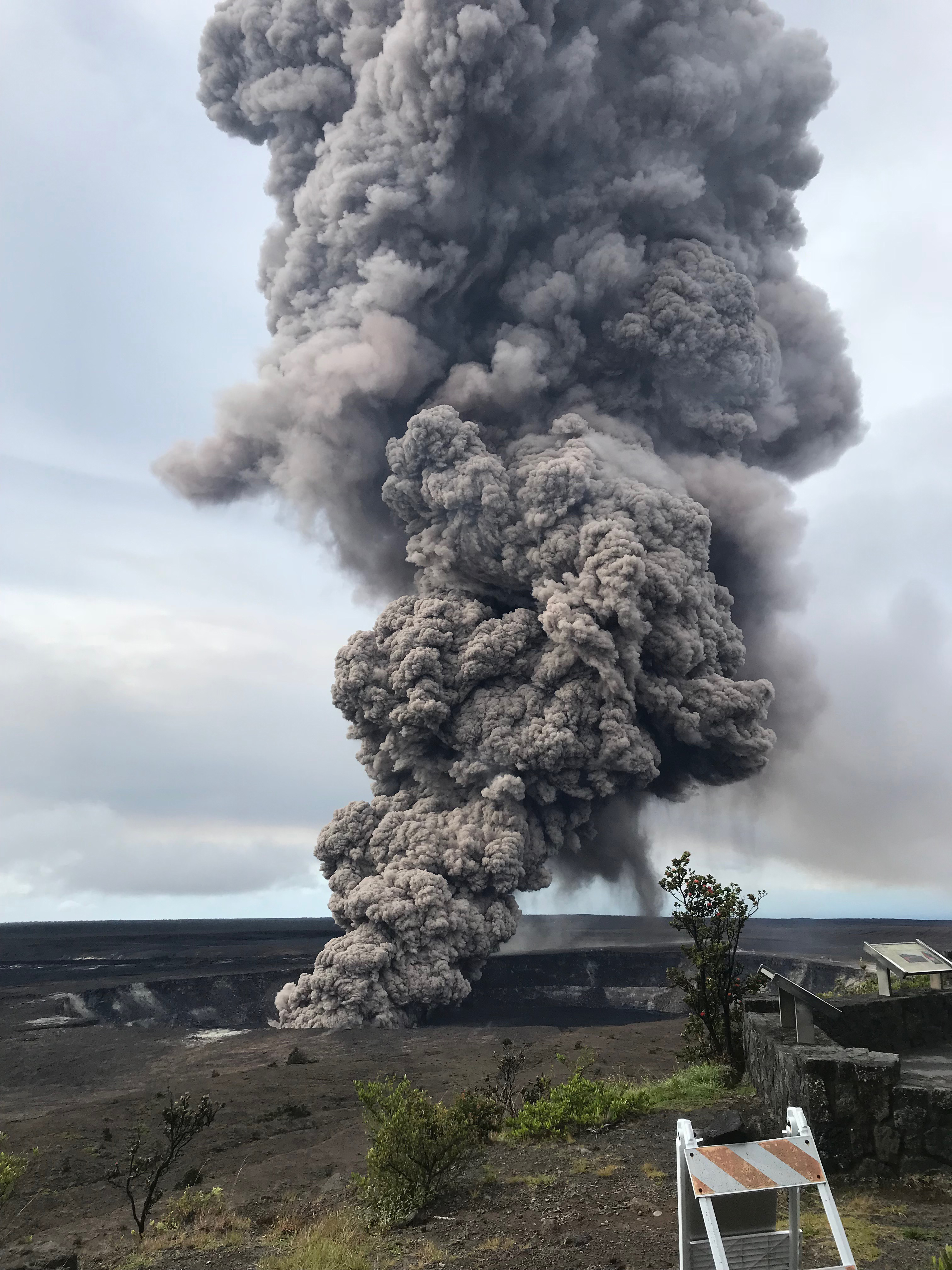
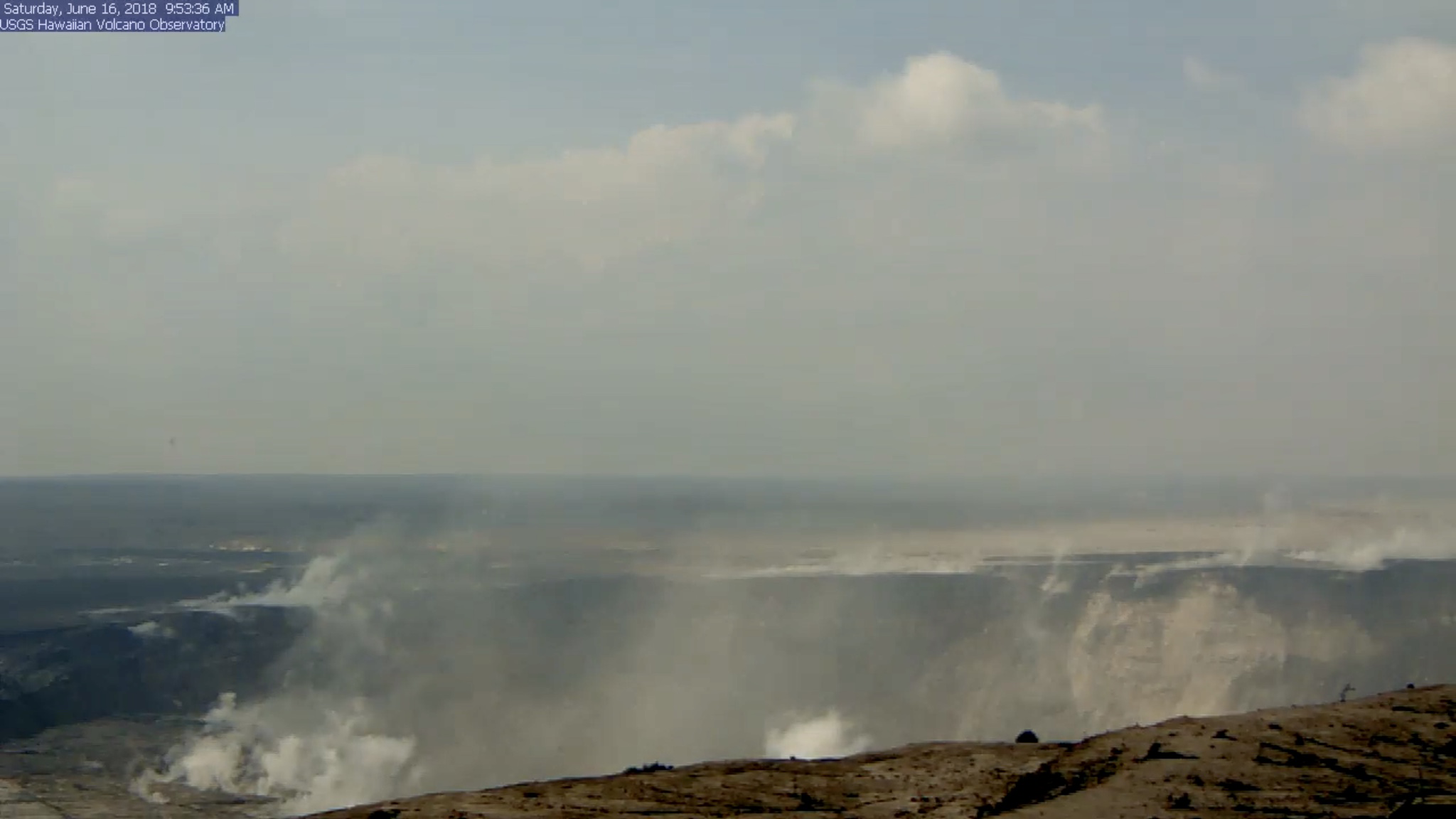
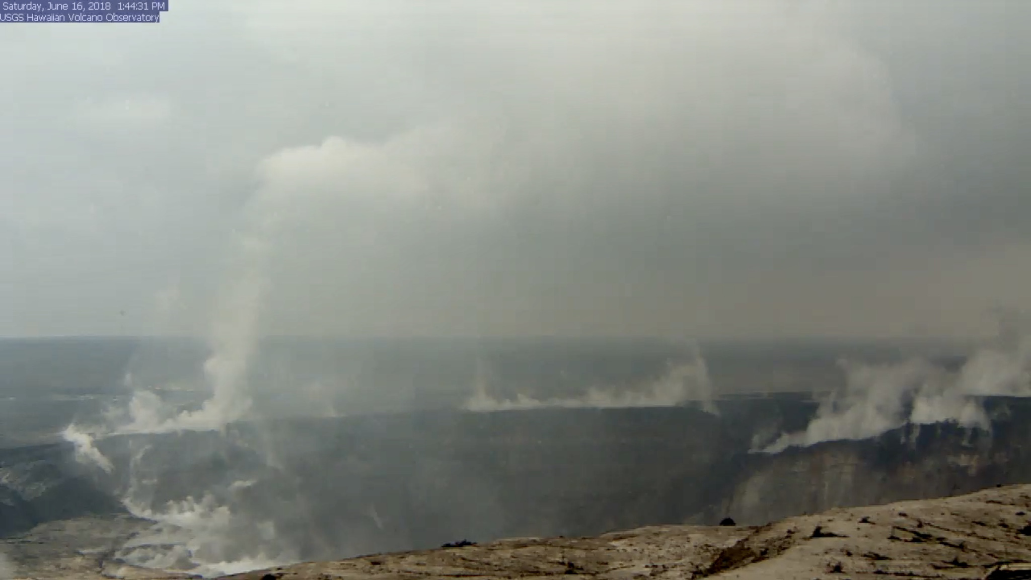
June 16: Change Caught on Livestream
I grabbed this video clip from the USGS/HVO Kilauea Summit Livestream on the morning of Saturday, June 16, 2018. This kind of collapse/subsidence has been happening every day since the end of May.
Here’s screengrabs from before and after that happened (I’ve boosted Brightness): 9:53am1:44pm
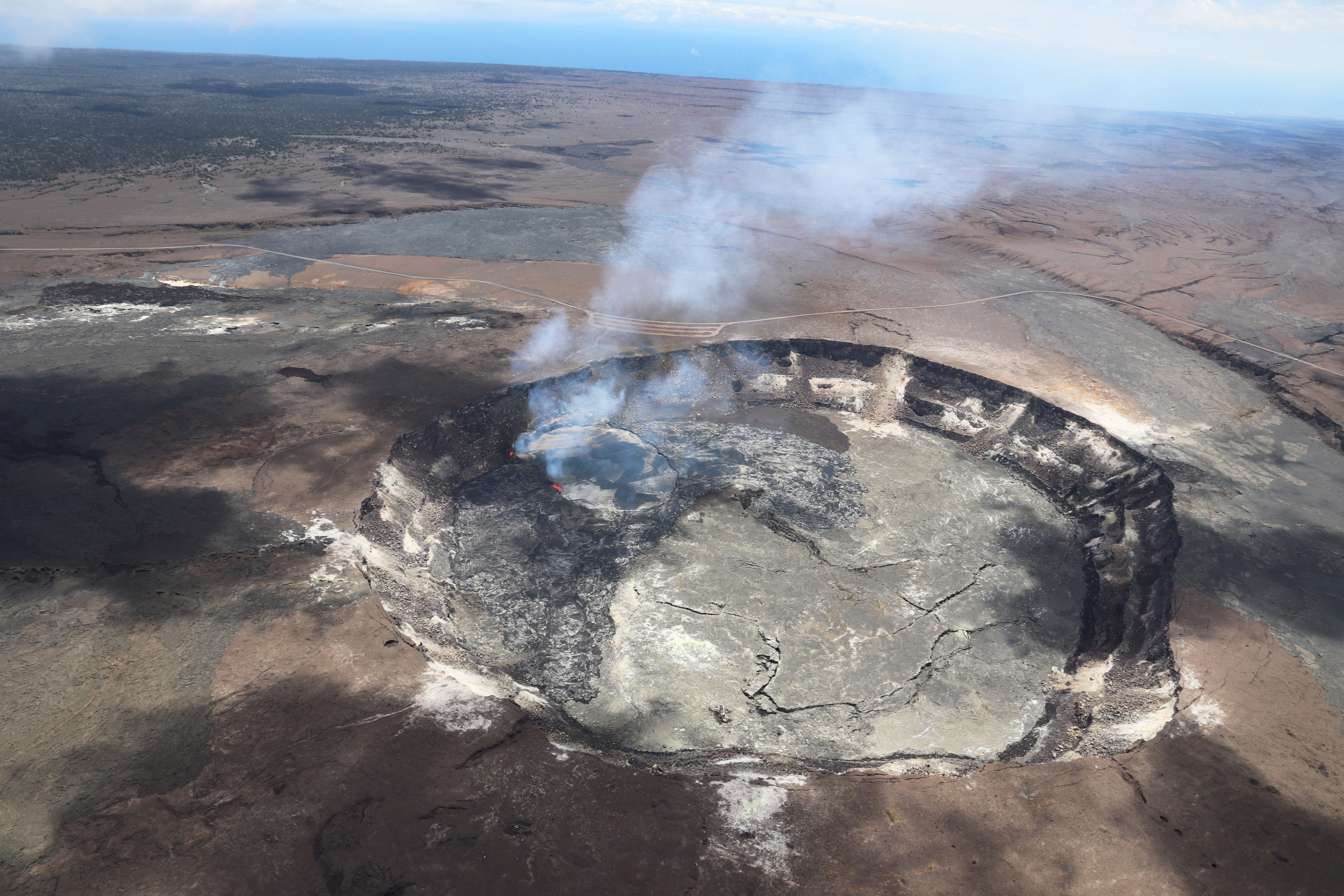
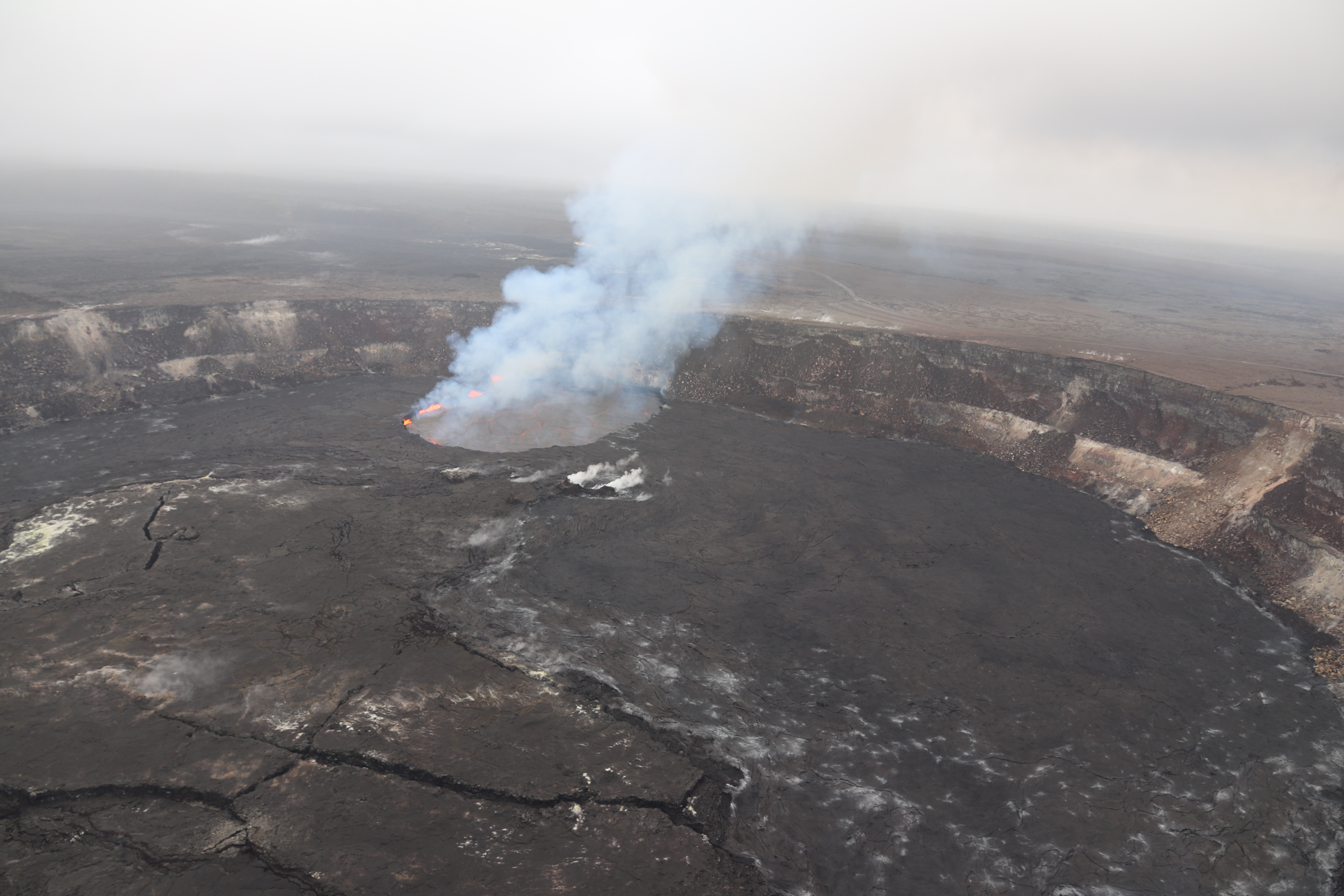
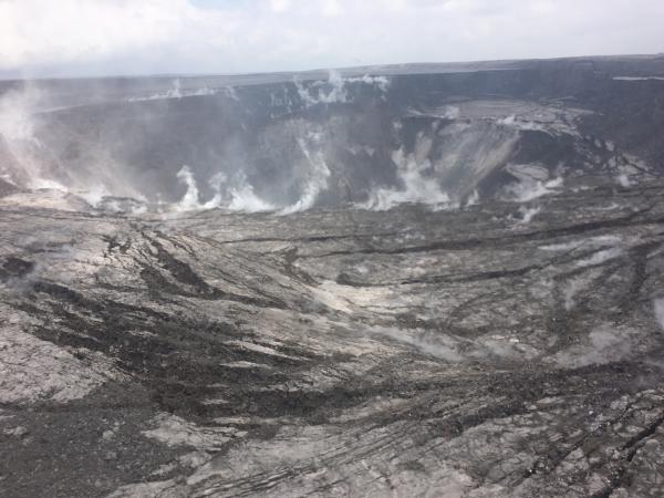
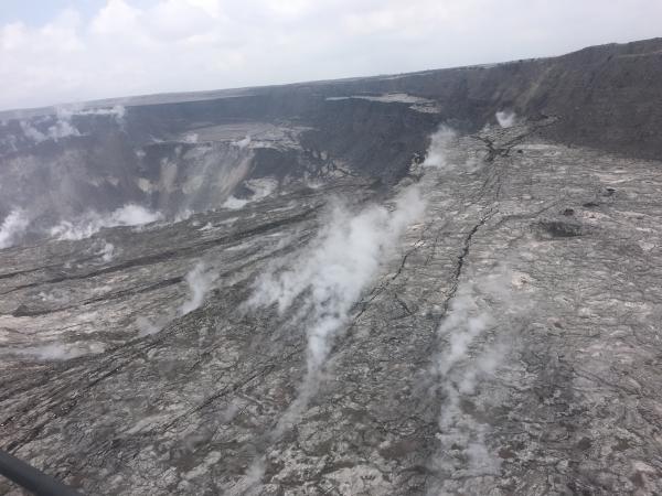
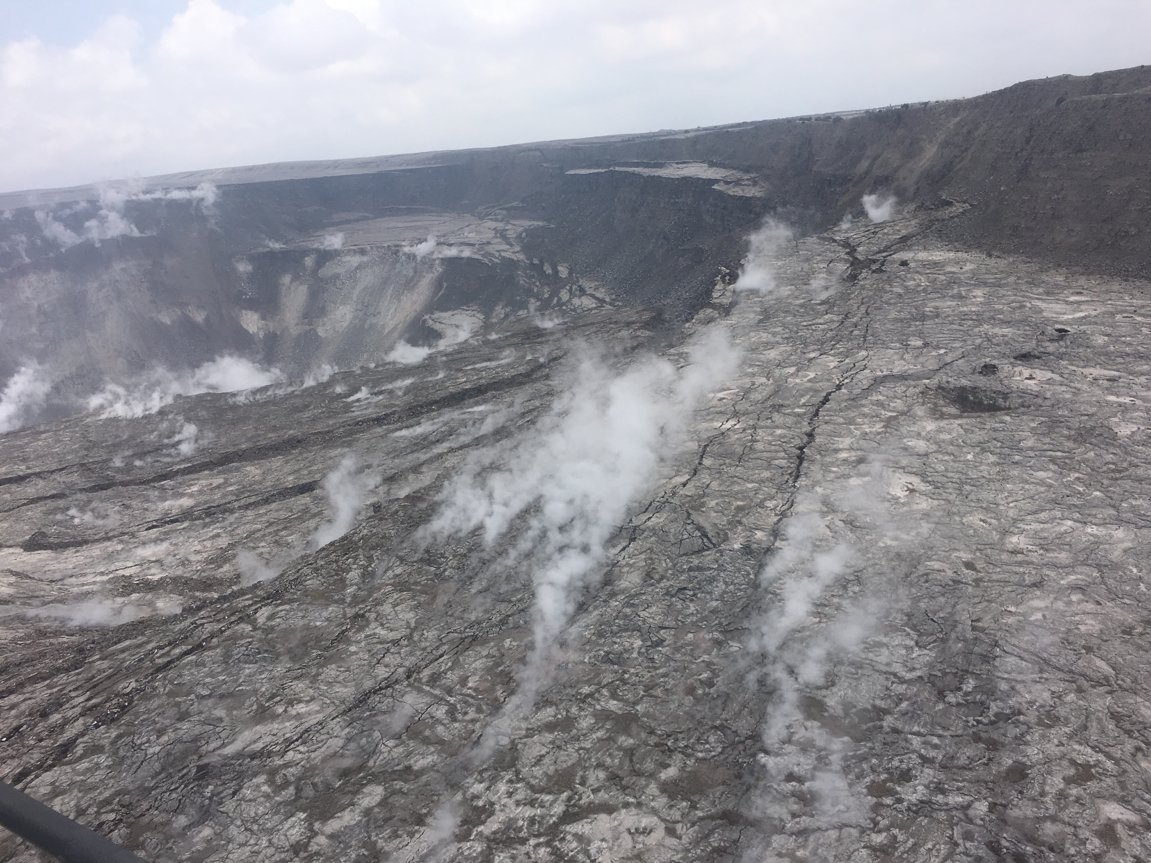
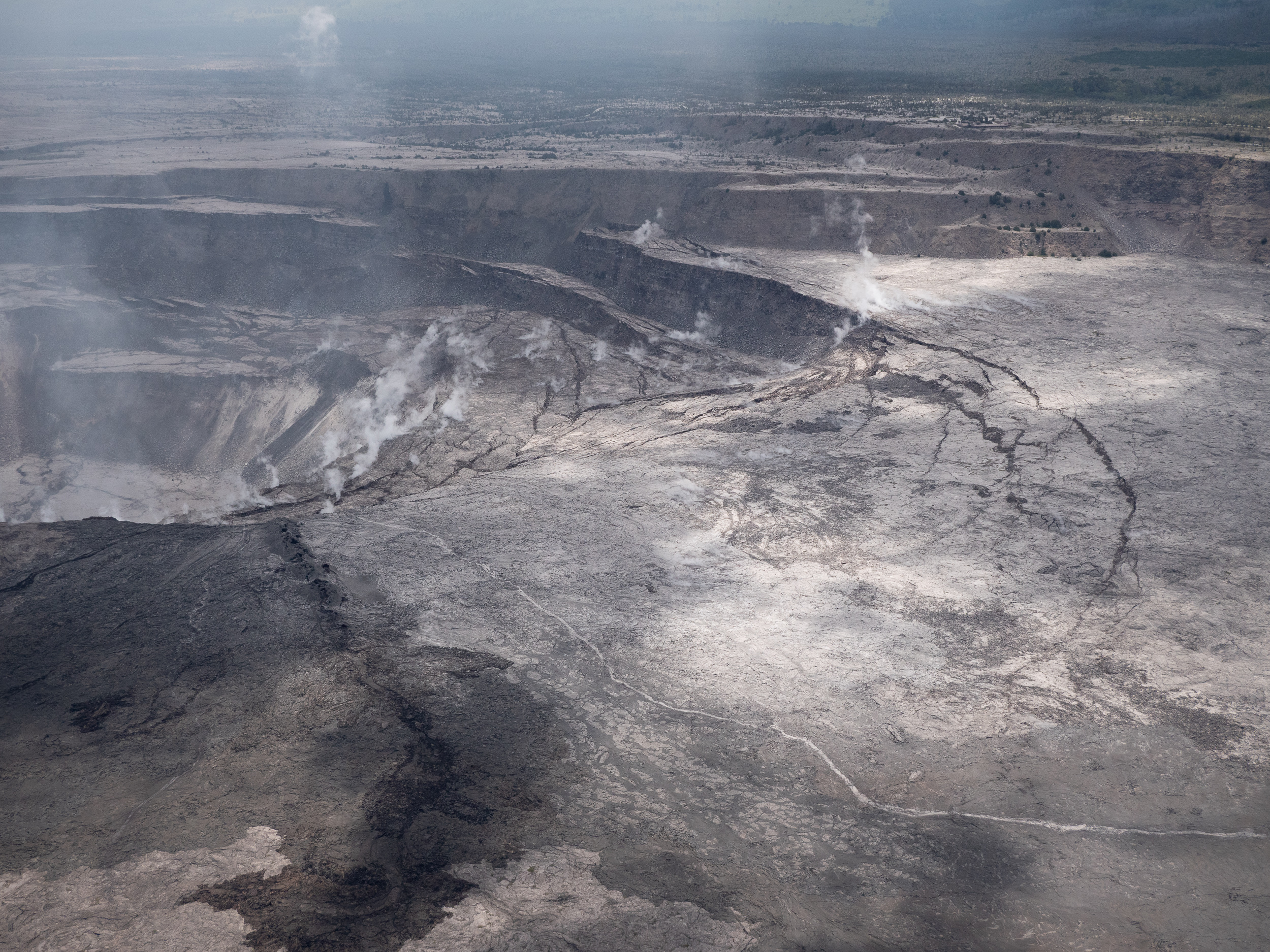
June 18, 2018 (USGS)
USGS: “North side of the growing Halema‘uma‘u crater, marked by large cracks and large blocks that have slumped into the crater.” (Full-sized)USGS: “An overflight of Kīlauea’s summit on June 18 showed the continued dramatic slumping and collapse of the Halema‘uma‘u crater area. This photo shows the area north-northwest of Halema‘uma‘u near a GPS station, North Pit. This station has subsided about 60 m (197 ft) in the past week.” (Full-sized)USGS: During the helicopter overflight on June 18, crews captured this image of the growing Halema‘uma‘u crater viewed to the southeast. With HVO and Jagger Museum sitting on the caldera rim (right side, middle where the road bends to the left) it is easier to comprehend the scale of subsidence at the summit. The estimated total volume loss is about 260 million cubic meters as of June 15th. (Full-sized)USGS: “Halema‘uma‘u viewed toward the west during the June 18 helicopter overflight. HVO and Jaggar Museum can barely be seen on the caldera rim in the upper right of the photograph.”Full-sized)
June 23 Collapse Explosion
June 24, 2018 drone footage (USGS)
Video starts with a photo of Halema’uma’u Crater on April 13, 2018, just before everything changed.
HVO Webcam Timelapses
Still can’t get enough? Hawaii247.com not only archives all the USGS overflight videos on its YouTube Channel, but also posts once-a-week timelapses from HVO webcams.


