May 25: End of the Road for Leilani Estates?

It looks like the coup de grace for Leilani Estates, or at least its eastern part.

USG Photo, May 25, noon overflight. Fissures 6 (left) and 13 (right) send lava flows south that join and flow down to ocean (white laze plume in distance). Note metal roof(?) embedded in lava at lower left. [Full-sized]
Three weeks ago Leilani’s streets were lacerated by fissures, battered by lava spattering from cracks, and blocked off by ponderous flows that seldom traveled far from their source. But that was a slow-motion disaster. Most fissures were active only a few hours. While a few unlucky residents lost homes in the first wave, most were able to return and collect vital possessions, or even risked dangerous fumes to stay.

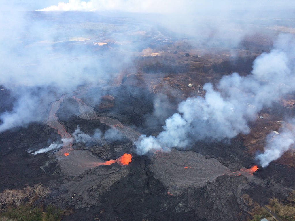
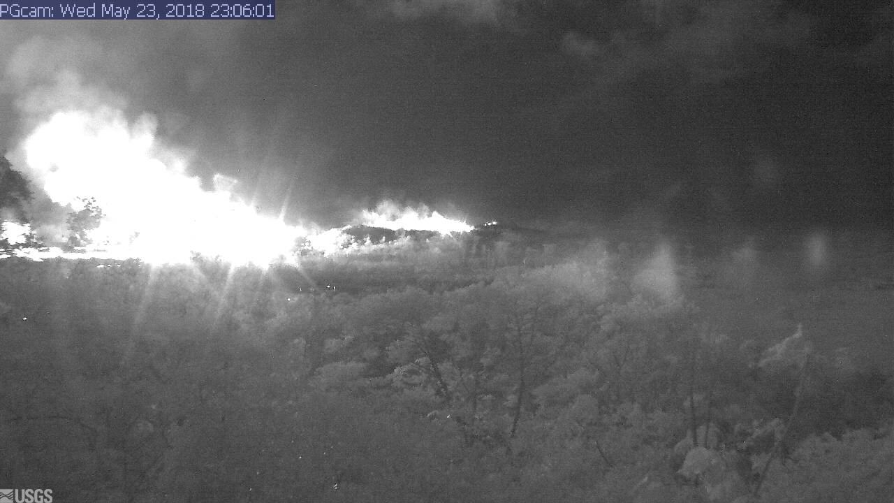
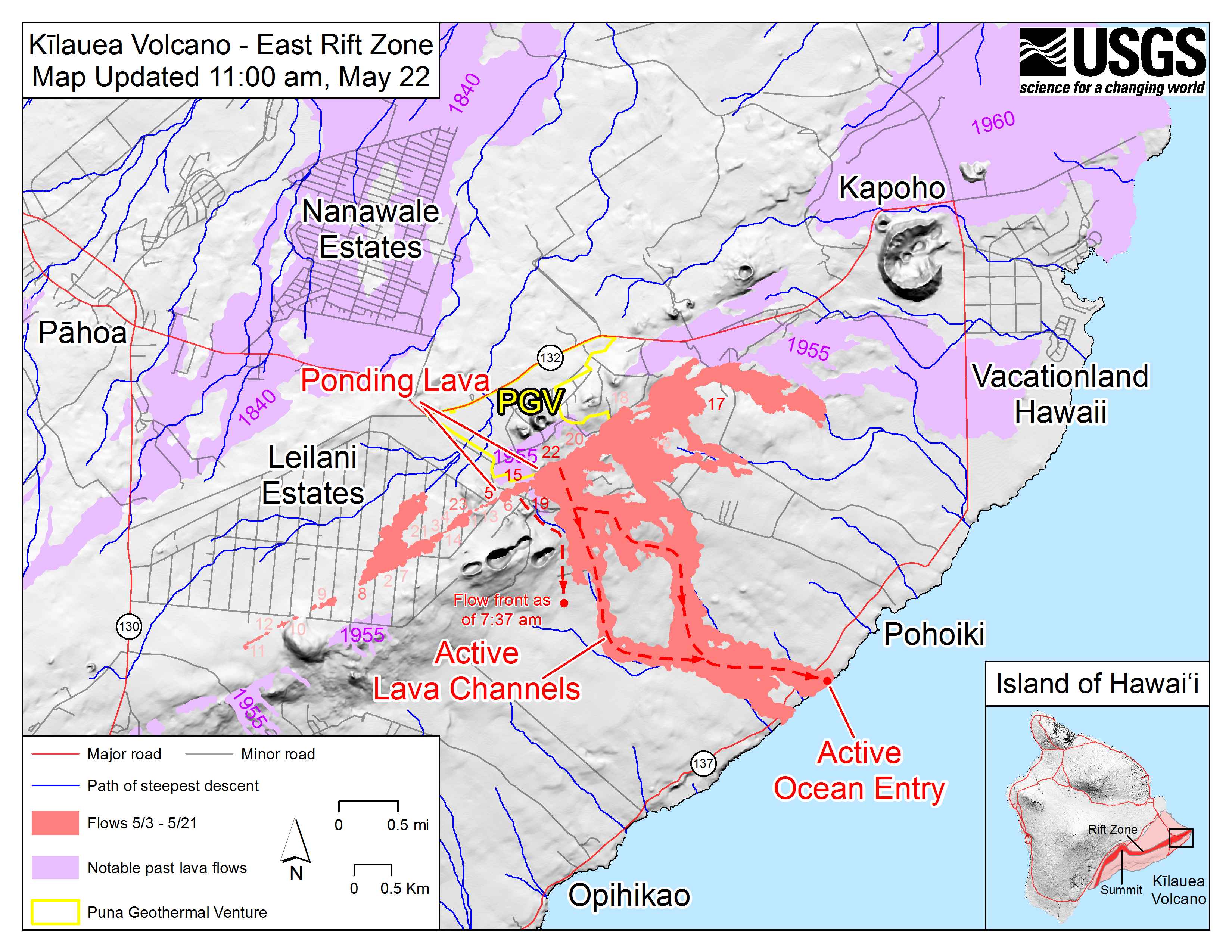
Last week, the main lava activity shifted east, downrift, overrunning smaller Lanipuna Gardens, threatening the PGV geothermal plant, and inundating fields and woods where homes were more scattered.  “Hotter, fresher” magma arrived last Thursday with a roar, spurting in several-hundred foot fountains and flooding forests with rivers of fast-moving pahoehoe lava. On Saturday night, these channels reached the ocean.

It was only a reprieve. A few days ago, the fissures that had given Leilani grief began reactivating. The group of fountains monitored by HCB’s livestream began to subside as uprift vents pilfered their magma supply.  Leilani’s reinvigorated vents poured out so much lava they created a pond, as well as sending new flows down to the sea. And through people’s houses:

Today, more streets were buried. Firefighters went door-to-door urging the last holdouts to flee before lava reaches them. Even parts of lower Puna not yet menaced by lava were ordered to leave before their remaining escape routes are cut off. Just in case, authorities have sent in the Marines.

82 structures lost. A two mile stretch of fissures in a residential area is pouring out an astonishing 40-60 cubit feet per second. And yet only 3.4 square miles have been covered by lava in this eruption, on an island of over 4000 square miles. But that doesn’t make it any easier for those affected.

Below, a roundup of Friday’s images, videos, USGS news, and reports from local news stations.

Continue reading May 25: End of the Road for Leilani Estates?

May 24: USGS Acquires Drones, Leilani Estates Acquires Lava Lake

Before this, the main thing USGS was using drones for was LIDAR, but today’s Photo & Multimedia entry on HVO’s website provides drone footage for both the summit steam/ash plume and Leilani/Puna lava flows.

SUMMIT ERUPTION:

This video was filmed on May 21, 2018, with a UAV (unmanned aerial vehicle). Limited UAV flights above the hazardous Kīlauea summit area, which is currently too dangerous for geologists to enter for ground observations, are conducted with permission from the National Park Service. […] At Kīlauea Volcano’s summit, a nearly continuous plume of gas and steam billows out of the Overlook vent and drifts with the wind. Explosions are occurring about two times a day, producing ash that rises to a height of between 8,000 to 10,000 feet above sea level. Small ash emissions occur more frequently. The larger explosions produce ash that is blown downwind, and trace amounts have fallen in nearby communities.

Addendum: there was a 6PM 10,000 foot ash explosion & plume this evening (Civil Defense photo, USGS video), sending ash southwest.

PUNA LAVA ERUPTION:

This footage is from an Unmanned Aircraft System (UAS) hovering near fissure 22 during the overnight hours of May 22, 2018, and looking down on the fountaining fissure complex. The view rotates upward (to the south) to track channelized lava as it flows toward the Pacific Ocean, about 3 mi (5 km) away. The ocean entry is in the distance, recognizable by a small plume. The USGS National Unmanned Aircraft Systems Project Office is assisting with remote data collection and mapping of lava flows and hazards…

HVO’s Photo & Multimedia blog also posted impressive Hilo Civil Air Patrol aerial photos of the lava rivers from yesterday, as well as an image of Fissure 22 taking a nap (it’s still going but lower today on Civil Beat’s Livestream) while the fissures west of it (and uprift) that activated yesterday inundated Leilani Estates.

As an aside: people keep posting ridiculous rumors, so the USGS had to reassure everybody that Mauna Loa is NOT erupting.

Latest video this evening from HNN reporter Mileka Lincoln:

Earlier in the day… welcome to the Leilani Estates Lava lake. (warning: noisy)

The residents are being absolute champs in coping with this. Here’s another video clip of the lava lake with the homeowner whose home is just outside of it. They’re very philosophical, realizing they took a gamble, which is more mature than some of the people criticizing them for taking a chance on a place that hasn’t had an eruption in about 60 years. And they’re helping one another.

Oh, my mistake. It’s a lava pond.

Mick Kalber’s helicopter overflight video today does a great job of showing the “pond,” the fissures headed from there past the geothermal plant, and the lava rivers flowing south from those fissures towards the ocea.

USGS Updates, News Roundup, And More Vivid Videos:

Continue reading May 24: USGS Acquires Drones, Leilani Estates Acquires Lava Lake

Pele’s Path: Eyewitness to History

HawaiiNewsNow has had the most in-depth and on-the-ground local coverage. Wednesday night they aired a half-hour documentary, Pele’s Path: Eyewitness to History.

Hawaii News Now – KGMB and KHNL

It’s a day by day look at how this has unfolded for the shaken residents of Puna, for the state officials scrambling to address this fast-moving crisis, and for those who are front-row witnesses to the power of nature at its most destructive… and yet beautiful.

May 23: Blue Flames? Now You’re Just Showing Off

Kilauea’s chief resident has found another way to amaze and/or injure people reckless enough to get too close to her redecorating:

I had a hunch the Lower East Rift Zone webcam would be interesting tonight. I wasn’t disappointed:

I see what they mean about the Leilani fissures further west (uprift, towards the camera) reactivating today.

Edited to add: Yikes.

It’s 11:06 PM in Hawaii; second screengrab an hour or so later.

I was about to hit post, when I saw erstwhile reporter Mileka Lincoln and her crew posted this. Wow.

(recorded just an hour ago at time of this post.)

Now, let’s have the evening roundup of poignant news, amazing views, and interesting science…

Continue reading May 23: Blue Flames? Now You’re Just Showing Off

May 22: Late Night News Roundup – More PGV Worries


First of all, Honolulu Civil Beat posted a video of Fissure 22 while his livestream cam  showcases the Fissure 20 complex.

Not that it really matters which is which, but I like to know what I’m looking at. 22 is sending lava down to the ocean (and the geothermal plant.)

May 22 East Rift Zone Fissure Map by USGS

I think the livestream house is on that raised bump to the right of “PGV,” with the camera pointed SE. I guess this map was devised when 20 was having a low spell earlier today.

Mick Kalber’s usual stunning flyover vid including rivers of lava and lava flows meeting the sea:

Okay, now that we know where we are, what’s happening? Good images, clips and news tidbits after the cut. The main story today was concerns about lava encroaching on the PGV geothermal plant, and the hazards it poses. But first…

Continue reading May 22: Late Night News Roundup – More PGV Worries

May 21: Daily Roundup, Fire & Water Edition

Mick Kalber’s daily helicopter flyover includes some intense views of the rivers of lava heading into the ocean, and the big complex of fountains— 20? 22? we’re starting to lose track— that have dominated the Lava Livestream With Rooster for the last several days.

May 21 Fissure Map (USGS Maps page)

The USGS thermal scan is very informative, too: an infrared satellite detects heat sources (the whiter the image, the hotter it is), and USGS then overlays it on a daylight satellite image of same area. Result, accurate map of where the main flows are, even when they crust over so the lava inside is hidden:

May 21 Heat map of today’s flows (USGS Maps page)

Below the cut: a digest of the day’s eruption news, USGS updates (summarized), and striking social media images and video clips like this:

Continue reading May 21: Daily Roundup, Fire & Water Edition

May 20: Sunday Eve News/Images Roundup

Today’s big activities were: (1) massive lava fountains/flows in the Lower East Rift Zone/Lower Puna, entering the ocean at two points (2 modest ash explosions from Halema’uma’u crater (they looked to me like the 10,000 foot range). I’m going to stop worrying about whether they’re triggered by steam explosions or rockfalls.

Late afternoon HNN update includes footage of lava entry into ocean:

Oh good, Mick’s posted the day’s flyover. Noisy helicopter, incredible views:

Also, the lava livestream continues. Someone posted a screencap with USGS scientists working below Fissure 20, giving a sense of scale:

KITV archived HVO’s afternoon alert:

Continue reading May 20: Sunday Eve News/Images Roundup

May 18: “Fresher, Hotter” Magma Arrives, HUGE Fountains Begin

Thursday May 18: Fissure eruptions went into overdrive [Good article from Star-Advertiser] as “fresher, hotter magma” (Janet Babb, USGS geologist) arrived from summit. Fissure 20 released a lava flow down toward coast, crossed Pohoiki Road, and isolated about 40 houses. Four cut-off residents were airlifted out.

Here’s an archived livestream by Honolulu Civil Beat starting before dawn Friday morning:

Check out daylight screencap from late in the broadcast to get sense of scale: note house.

The USGS also posted a brief video clip of Fissure 17 in its Kilauea-Iki-like glory:

May 19, Friday afternoon, a new livestream started from same channel  as before (civilbeat.org). They streamed through most of the night, occasionally shifting view from large fountain behind house (Fissure 17) to lava flow and a group of lava fountains building spatter ramparts (Fissure 20 merged with others) upslope to the right.

Friday, HawaiiNewsNow’s Milika Lincoln filmed same area in late morning from nearby location, near Lanipuni Gardens: fissure 17 fountain was now 500 feet tall. There seems to be a crater (pu’u) forming to the right of 17’s fountain. She also interviewed a resident who saw Fissure 17 form— as they talk, it roars. After dark, her crew’s footage is absolutely spectacular. (She’s calling it 19— either I’m mistaken about which one she’s watching, or she is.)

You can really tell this is hotter, fresher, more voluminous lava that drained from Pu’u O’o, as opposed to the old, stiffer, cooler lava that erupted from fissures in Leilani Estates the first two weeks of this eruption.

“Ground deformation is continuing with increased seismicity” in Lower East Rift Zone, and USGS warn lava inundation below them is possible, and that more fissures could still open uprift or downrift. “All fissures are actively spattering or actively degassing.” 40 structures lost.

May 13: Fissure 17 Starts

I’ve not covered every single fissure: see the HVO Photo/Multimedia blog, the HVO timeline, KITV, and HawaiiNewsNow for fissure-by-fissure coverage, not to mention HNN reporter Milika Lincoln’s Instagram vids and photos, and Mike Kalbers’ wonderful daily flyovers.

Activity ebbed and flowed, some days with more steam, some with more spatter. For the most part, lava flows didn’t go very far, and were largely sticky, clumpy, clanky a’a. But I bookmarked fissure 17 early on for particularly dramatic fountains (those blocks it’s hurling are called “lava bombs”) and incredible booms and roars:

#LeilaniEstatesEruption LATEST (May 15 at 8:30 AM): Incredible new sunrise footage captures the sounds and sight of lava fountains and gas bombs erupting from the 17th fissure — which broke out Saturday off of Halekamahina Loop Road northeast of Lanipuna Gardens on the Kalapana side of Highway 132. According to USGS HVO scientists, fissure 17 has created a narrow lava flow heading makai — or downslope toward the ocean — and has already covered about two miles. Civil Defense officials say based on their last measurement, this flow front is now a little less than a mile from Highway 137. At one point yesterday, it was moving at a rate of about 100 yards an hour, but it has since slowed a bit. The flow has been running roughly parallel to Highway 132 or Pahoa Kapoho Road. Officials say it's heading east in the direction of Kapoho toward Highway 137 — also called Old Government Beach Road, or more commonly referred to by residents as Waa Waa Road. This fissure has already claimed one structure — but officials say there are currently no homes or buildings in its current path. This has been the longest-lasting, most active fissure of the 20 that have opened up since this the first on May 3 along Mohala Street within #LeilaniEstates. Stay tuned to @HawaiiNewsNow for the very latest developments #HInews #HawaiiNews #HNN #HawaiiNewsNow #WeAreYourSource (Video: @bradah.dom / @ikaikamarzo)

A post shared by Mileka Lincoln (@milekalincoln) on

and it was the first one that really seemed to be making a run for the ocean and creating a sustained lava flow.

Here’s May 13 and 14th flyovers from Mick Kalber:

Luckily, it chose a route that doesn’t have many houses downslope. And unlike other fissures, it just kept going and going.

And (since I’m posting this backdated): it’s still going on May 19, after making quite an impressive lava fountain and cinder cone for itself over the past two nights.